Report on Poas (Costa Rica) — May 1989
Scientific Event Alert Network Bulletin, vol. 14, no. 5 (May 1989)
Managing Editor: Lindsay McClelland.
Poas (Costa Rica) Ash emission, then rains produce new lake; gas chemistry
Please cite this report as:
Global Volcanism Program, 1989. Report on Poas (Costa Rica) (McClelland, L., ed.). Scientific Event Alert Network Bulletin, 14:5. Smithsonian Institution. https://doi.org/10.5479/si.GVP.SEAN198905-345040
Poas
Costa Rica
10.2°N, 84.233°W; summit elev. 2697 m
All times are local (unless otherwise noted)
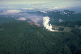
The crater lake, which had been shrinking since early 1987, disappeared by 19 April. After the lake's disappearance, columns of mud rose 10-350 m, building a cone that was 15 m high and contained seven active vents by 26 April. The vigorous 22 April explosive activity deposited lake sediments 600 m to the W. The explosion at dawn on the 28th, directed toward the S, again deposited lake sediments, to 2 km from the rim of the inner crater. Material on the bottom of the crater continued to dry, and emission of lithic ash began during the night of 30 April. Winds carried ash W and SW, where it fell on the towns of Toro Amarillo, Palmira (16.5 km W), Zarcero (18 km W), and Sarchí (18 km SW). Similar eruptions continued through the day on 1 May. A fumarole W of the 1953-55 [dome] had a temperature of 95°C on 26 April. The number of long-period events recorded by Univ Nacional seismic instruments declined in April to a mean of 218/day (through 26 April; figure 17). The events were of low frequency (1-2 Hz) and very shallow. Low-frequency (1.75 Hz) tremor began to appear on seismic records 19 April.
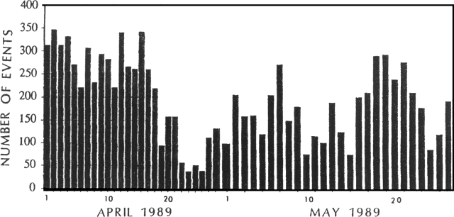 |
Figure 17. Number of local seismic events/day recorded at Poás by the Univ Nacional, 1-26 April and 1-26 May, 1989. |
Similar activity continued into May. Emissions of gas and ash (composed of old lake sediments) from various vents were continuous. The largest gas/ash emissions occurred from the mud cone that had formed in the center of the crater. Winds generally carried ash toward the W and SW [see also 14:06]. With the onset of the rainy season in mid-May, the bottom of the crater was covered with water, forming a new lake. Mud eruptions again dominated the activity, depositing ejecta within the crater. Small ash eruptions continued only from one point on the W side of the crater. On 25 May, a phreatic eruption destroyed the mud cone, depositing debris outside the crater. Through the end of the month, activity was confined to small mud eruptions, reaching about 5 m height, and continuous gas emission affected towns W and SW of Poás. As of 26 May, Univ Nacional seismic instruments had recorded a mean of 175 events/day during the month (figure 17). Amplitudes oscillated between 10 and 30 mm, with frequencies of 1.5-3.0 Hz. Volcanic tremor amplitude was generally 4-5 mm with a frequency of 1-1.5 Hz, but sometimes reached 10 mm amplitude and 2.5 Hz.
Geological Summary. The broad vegetated edifice of Poás, one of the most active volcanoes of Costa Rica, contains three craters along a N-S line. The frequently visited multi-hued summit crater lakes of the basaltic-to-dacitic volcano are easily accessible by vehicle from the nearby capital city of San José. A N-S-trending fissure cutting the complex stratovolcano extends to the lower N flank, where it has produced the Congo stratovolcano and several lake-filled maars. The southernmost of the two summit crater lakes, Botos, last erupted about 7,500 years ago. The more prominent geothermally heated northern lake, Laguna Caliente, is one of the world's most acidic natural lakes, with a pH of near zero. It has been the site of frequent phreatic and phreatomagmatic eruptions since an eruption was reported in 1828. Eruptions often include geyser-like ejections of crater-lake water.
Information Contacts: J. Barquero, E. Fernández, and V. Barboza, OVSICORI.