Report on Krafla (Iceland) — May 1989

Scientific Event Alert Network Bulletin, vol. 14, no. 5 (May 1989)
Managing Editor: Lindsay McClelland.
Krafla (Iceland) Four years of inflation interrupted by deflation
Please cite this report as:
Global Volcanism Program, 1989. Report on Krafla (Iceland) (McClelland, L., ed.). Scientific Event Alert Network Bulletin, 14:5. Smithsonian Institution. https://doi.org/10.5479/si.GVP.SEAN198905-373080
Krafla
Iceland
65.715°N, 16.728°W; summit elev. 800 m
All times are local (unless otherwise noted)
Krafla last erupted in September 1984 (9:8 and 10-11) and slow, intermittent inflation has been recorded since early 1985. Tilt records (figure 12) show three inflationary pulses since January 1988. Each lasted 2-3 months and was accompanied by increased seismicity. The inflation rate was generally 1-2 mm/day at the center of deformation, indicating a magma flow rate of ~1 m3/s into Krafla's shallow magma reservoir. Slow deflation was observed March-May 1989, accelerating 20-30 May to a rate similar to the previous inflation. No unusual seismicity or surface activity was associated with the deflation.
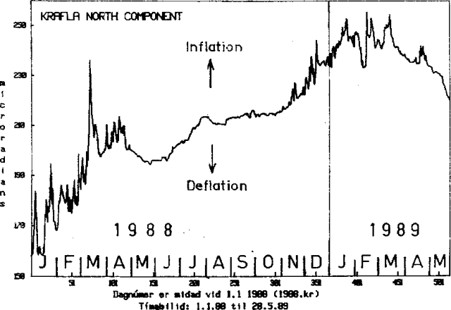 |
Figure 12. North component of tilt recorded January 1988-May 1989 at the Krafla power station, ~1.5 km S of the center of the deformation. Inflation is uplift toward then N. Courtesy of Eysteinn Tryggvason. |
Geological Summary. The Krafla volcanic system in the Northern Volcanic Zone (NVZ) of Iceland is about 100 km long, consisting of a fissure swarm and a central volcano with a 7 x 9 km caldera formed about 110,000 years ago that deposited a rhyolitic welded tuff. It has been moderately active in the Holocene, over three distinct eruptive periods; the current one has lasted about 2,800 years with six volcano-tectonic episodes, each with one or more basaltic fissure eruptions. Lava volumes (DRE) have been in the 0.1-1 km3 range. The Hverfjall and Ludent tuff rings east of Myvatn were erupted along the fissure system. Myvatn lake formed during the eruption of the older Laxarhraun lava flow from the Ketildyngja shield volcano of the Fremrinamur volcanic system about 3,800 years before present (BP); The present Myvatn lake is constrained by the roughly 2,000 years BP younger Laxarhraun lava flow from the Krafla volcanic system. The abundant pseudocraters that form a prominent part of the Myvatn landscape were created when the younger Laxarhraun lava flow entered the lake. The last eruption took place in 1975-1984 CE when nine small basaltic fissure eruptions produced 0.25 km3 of lava.
Information Contacts: E. Tryggvason, NVI.