Report on Redoubt (United States) — December 1989
Scientific Event Alert Network Bulletin, vol. 14, no. 12 (December 1989)
Managing Editor: Lindsay McClelland.
Redoubt (United States) Lava dome destroyed by explosions; major mudflow; smaller explosions followed by renewed lava extrusion
Please cite this report as:
Global Volcanism Program, 1989. Report on Redoubt (United States) (McClelland, L., ed.). Scientific Event Alert Network Bulletin, 14:12. Smithsonian Institution. https://doi.org/10.5479/si.GVP.SEAN198912-313030
Redoubt
United States
60.485°N, 152.742°W; summit elev. 3108 m
All times are local (unless otherwise noted)
A series of explosions 14-19 December was followed by extrusion of lava into the active crater in late December. The lava dome was destroyed by strong explosions 2 January that triggered a major mudflow into the Drift River. Mud flowed against but did not penetrate the inner dikes protecting tanks at the Drift River oil facility. Vigorous explosions occurred again on 8 and 16 January, causing widespread light ashfalls, but associated mudflows were smaller. Lava extrusion had resumed on 18 January and seismic evidence suggested that it was continuing on 21 January.
Aerosols from the explosive activity have not yet been widely reported, but lidar instruments in Germany detected new material near the tropopause and aerosol layers were evident at sunrise over Colorado (see Atmospheric Effects in 14:12).
Petrography of 15 December tephra.Thin sections of a pumiceous juvenile lapillus and a lithic fragment, erupted 15 December, were examined at Michigan Technological Univ 60% of the pumiceous sample was vesicular colorless glass with refractive index
Avalanche and lahar deposits emplaced 14-19 December. Reconnaissance fieldwork on the N flank 26 December revealed thick deposits from a slush avalanche that appeared to have been triggered by pyroclastic flows, perhaps on 15 December. Scouring had occurred across the entire glacier where it was confined by valley walls, but only on the E half of its unconfined 3-km-wide lower portion. Water that apparently originated near the cloud-covered summit was flowing into the Drift River from a narrow channel eroded in the glacier. The avalanche deposit was roughly 10 m thick at a sampling site about 1 km beyond the nose of the glacier, which extends roughly 8 km from the vent. The deposit was very massive, with no grading or vertical sorting evident, although contacts could be seen between individual flow units (3 of which were evident from the helicopter). Breadcrust blocks that reached a maximum of about 1/2 m in diameter (in a very limited sample) were supported by a matrix of sand-sized ash, snow grains, and liquid water. After emplacement, water had drained from the upper portion of the deposit, leaving noticeable air space between ice grains, and saturated the snowpack below the avalanche, which refroze into a zone of horizontally banded ice. A sample from near the base of the avalanche had a bulk density of 1.09 g/cm3, with proportions by volume of 20% rock, 72% ice, and 8% pore space. Bulk densities of 2 samples from the porous upper portion of the deposit were only 0.85 and 0.72 g/cm3; one of the samples had volume proportions of 9% rock, 71% ice, and 20% pore space. Densities of the pyroclastic rock clasts ranged from 1.1 to 1.4. The avalanche had apparently been slushy during emplacement. Measurements of runup onto an older avalanche fan at a site 3.7 km below the nose of the glacier suggested a velocity of roughly 17 m/s.
Subsequent floodwaters eroded the distal portion of the slush avalanche and carried numerous large ice blocks as far as the mouth of the Drift River, forming levees that helped to confine later flows. Some of the stranded ice blocks, which reached many meters in diameter, were clear glacial ice, others were eroded pieces of the slush avalanche. The flood rafted ice blocks to 8 m above the riverbed and 1.3 m up the 4-m L-shaped outer levee at the Drift River oil facility.
Airphotos taken 16 December showed small lahars with lobate snouts that extended several kilometers down the SW side of the volcano. Most of the lahar deposition occurred below a 1/2-km-wide zone of roughly parallel erosional grooves that extended down the upper flank glaciers from the low point of the crater's S rim. However, patchy deposition occurred up to the crater rim, and the grooves were streaked with dark mud.
Summit lava dome. About 21 December, a change in the character of local earthquakes and a slight increase in the number of small shocks suggested to geologists that magma might be approaching the surface. Poor weather continued to obscure the vent area, although a vapor plume that reached 7.5 km altitude and sulfur odor at about 3.5 km altitude were detected from aircraft on 22 December. Seismic activity declined slightly on 24 December, but numerous small earthquakes continued to occur near the summit.
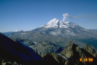
An overflight 26 December revealed a large elongate lava dome that emerged from a vent at the N edge of the 1.5-km-wide U-shaped breached crater, filled much of its N portion, and extended partway down the N flank. Many hot rock avalanches cascaded down the dome's steep N side, generating small billowing ash clouds that rose 300-600 m above the dome. The volcano continued to produce a vigorous vapor plume, primarily from the S side of the dome. Summit glow was visible at night roughly 80 km E of the volcano (on a low-light video camera at Kasilof). A slight increase in small earthquakes and rock avalanches near the summit during the next few days suggested an increased rate of lava extrusion. Ground and aerial surveys on 29 December confirmed significant additional growth of the dome, which was estimated from the air at roughly several hundred meters wide and twice as long. A vigorous gas plume that contained little ash rose 3.5-4.5 km. The dome had grown further by 1 January, and AVO estimated its volume at roughly 20-25 x 106 m3.
Strong explosions and mudflow, 2-3 January. Shallow microearthquakes associated with the lava dome and deeper events centered 7-10 km below the volcano began a rapid increase after a magnitude 1.9 earthquake, the largest of the eruption thus far, at 1934 on 1 January. By the next afternoon, seismic energy release had built to about the same level as immediately before the start of the eruption on 14 December. At 1600 on 2 January, AVO issued a statement noting the potential for partial collapse of the dome's unstable N flank, deposition of hot tephra onto the glacier with resulting flooding in the Drift River valley, and moderate to strong explosive activity. The Drift River facility was promptly evacuated.
Less than 2 hours later, a vigorous explosion at 1748 had the strongest seismic signal of the December-January eruption. Airplane pilots reported that the tephra column reached 13.5 km altitude; they saw apparent lava fountaining in the summit area, and noted incandescent material moving down the N flank into the upper Drift River valley. Residents of the Kenai Peninsula, across Cook Inlet from Redoubt, reported spectacular lightning. Ash moved NE in light wind, and minor ashfalls occurred at Anchorage. Satellite images (figure 3) showed a plume extending NE about 20-30 km at 1800, growing steadily to 430 km long and 620 km wide 6 1/2 hours later. Cloud top temperatures as cold as -53°C were measured from satellite data, yielding altitude estimates of roughly 8-8.5 km. The FAA issued warnings to aircraft, and most airlines cancelled flights to and from Anchorage. Another large explosive episode was recorded at 1927, and tephra was reported to 12 km altitude. Smaller explosive episodes were recorded at about 0130 and 0245 on 3 January.
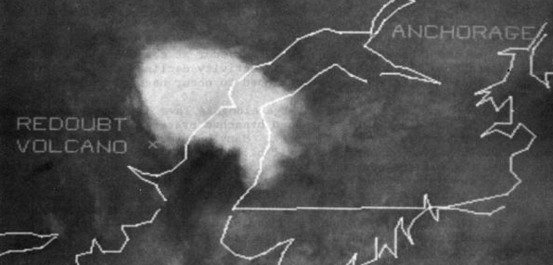 |
Figure 3. Thermal infrared image from a NOAA polar orbiting satellite on 2 January at 1915, about 90 minutes after the onset of the explosive episode. Cloud top temperature suggests the plume is at about 8.5 km altitude. Courtesy of Michael Matson. |
During an AVO overflight between 1230 and 1300 on 3 January, a turbulent steam plume with only minor ash rose through weather clouds to 4-4.5 km. Clouds obscured the summit area on 3 January, but overflights during better weather 2 days later showed that the dome had been removed along with a substantial part of the upper Drift Glacier. Seismic activity had declined to the lowest level since the eruption began and there was no seismic indication of renewed lava extrusion.
Pyroclastic flows during the 2 January activity generated a major mudflow that covered the entire active flood plain of the Drift River to the head of its delta, inundated the delta, and reached Cook Inlet, 32 km from the vent. An area of about 60 km2 was affected. Peak discharge at a site about 18 km from the vent was estimated to be roughly equal to that of Ruiz volcano's November 1985 Río Azufrado lahar. The pyroclastic flows incorporated large amounts of ice and snow, and were transforming into lahars by the time they reached 700 m altitude, near the nose of the glacier. The flow transported high-density, high-temperature dome rocks to the coast and carried ice blocks several meters in diameter that did not rise to the flow surface, indicating that it remained a fully developed debris flow. Boulders, more visible from the air at the lower end of the deposit, reached 4 m in diameter; many were still hot and generating small steam plumes on 3 January. Water pushed aside by the debris flow inundated the area N of the main Drift River delta, forming a large lake. Ice jams formed at the mouths of small streams in that area, temporarily damming them. Heavy deposition in its main channel diverted the Drift River into a stream with considerably less capacity (Rust Slough) S of the oil facility, protected on that side by neither dikes nor topography. Water and debris were then able to flow around the 4-m outer dike, crossed the facility's landing strip, damaged support structures, and shut off electricity, but did not overflow the 2.5-m inner dikes protecting individual oil tanks. The tanks were not damaged and no oil was spilled. Crews returned during daylight on 3 January to begin cleanup. The flooding at the Drift River facility forced the shutdown of 10 of the 12 Cook Inlet oil production platforms.
Explosions and debris flows, 8-16 January. Strong explosive activity resumed 8 January with vigorous episodes at 1012 and 1048 (figure 4). No seismic precursor was noted, although the nearest seismic station, on the N flank, had been damaged in the 2 January eruption. Within 30 minutes, plumes reached 12-13.5 km altitude. The FAA issued an advisory to aircraft, and some flights were cancelled. Ash fell on the flanks and on a broad sector to the E, beginning about noon at Kenai (80 km E of Redoubt). Only a dusting of ash fell on Kenai, but Kasilof, about 25 km to the S, received more than 0.5 cm and was in "total darkness" at 1230. More than 1 cm accumulated at Soldotna, between Kenai and Kasilof. By 1430, satellite images showed that the plume, about 100 km long and 125 km wide, had detached from the volcano and extended nearly to Anchorage. Overflights later that day revealed no major changes to the summit area. A plume that was mainly vapor rose to about 5 km altitude [see also research aircraft data in 15:1].
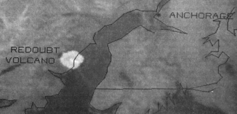 |
Figure 4. Thermal infrared image from the NOAA 10 polar orbiting satellite on 8 January at 1026, about 15 minutes after the explosion began. The eruption cloud is rising to about 12-13.5 km altitude. Courtesy of Michael Matson. |
The 8 January pyroclastic flows triggered a debris flow much smaller than that of 2 January, but with a peak discharge comparable to that of the 18 May 1980 mudflow from Mt. St. Helens in the N fork of the Toutle River. One or perhaps 2 pyroclastic flows continued in a relatively dry state to below 500 m altitude on the glacier. Debris flow material was initially concentrated in a deep gully on the E side of Drift Glacier, then spilled NE across the floor of the Drift River valley (figure 5 from 15:01). The flow bifurcated around a small hill on the valley floor; the S lobe stopped abruptly, but the larger N lobe continued downvalley, transforming into a hyperconcentrated flow within 15 km of the vent. It spilled through a breach in the moraine that enters the valley from the Drift River lobe of Double Glacier, and continued for another 5.5 km. Ultimately the flow became sediment-laden before stopping above the head of the Drift River fan. There was no noticeable impact on the channels downstream. After the 8 January activity, the main debris flow channel was stripped of ice down to about 1250 m altitude, and ice was only intermittently evident for the next couple of hundred meters.
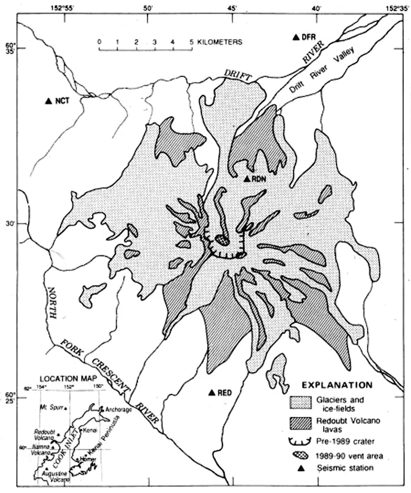 |
Figure 5. Generalized map of Redoubt, showing the 1989-90 vent area and locations of seismic stations monitored by the Alaska Volcano Observatory. Reprinted from Alaska Volcano Observatory Staff, 1990. |
A small explosive episode lasting roughly 15 minutes was recorded seismically on 11 January at 1001. No clear seismic precursor was detected, and poor weather prevented observations of the plume. Another brief eruption was reported at 1342, and a pilot estimated that the steam and ash cloud reached 12-13.5 km altitude. Multi-layered weather clouds made plume identification difficult on satellite images.
A 20-minute explosive episode that began at 2248 on 16 January produced widespread ashfalls. Pilots reported ash to 9 km altitude and satellite data indicated that the plume reached 11.5 km. By 0015, ash was falling in Skwentna, 170 km NE of Redoubt, where more than 1/2 cm accumulated. Ash mixed with snow fell in Cantwell, 370 km NE of Redoubt, and began at Eilson Air Force Base (near Fairbanks, 550 km from the volcano) at 1111. Ash then continued E toward Canada.
Data from debris flow detection devices indicated that a water and debris flow occurred in the upper Drift River within about 20 minutes of the eruption's start. One device, placed on the 8 January debris flow deposit, was triggered but not destroyed, suggesting that the 16 January flow was smaller. Considerable snow had accumulated on the Drift River flood plain since 8 January, and the flow continued to accumulate water as it continued downstream. Although the flow volume was not large in comparison with earlier episodes, it was sufficient to cause some of the water in the Drift River to return to its old channel. Personnel at the Drift River oil facility reported that no flooding occurred there.
Renewed lava extrusion, 18 January. Aerial observations on 18 January between 1330 and 1500 revealed that a small lava dome was again growing in the vent [see also 15:1]. A vigorous steam plume rose to about 5 km altitude. Seismicity the next day suggested that lava continued to be added to the new dome. Small seismic events on 19 January at 0522 and 0655, each lasting 15-20 minutes suggested vigorous venting that may have included some ash emission, but the activity was not witnessed.
Drift River oil facility. Concern about the potential for a major oil spill prompted the removal of most of the more than 900,000 barrels of oil that were stored in the Drift River facility's 7 tanks at the start of the eruption. Oil is transported by pipeline to the Drift River facility from 2 small coastal storage facilities (not accessible to tankers) that serve production platforms in Cook Inlet. Drainage of the Drift River tanks began about 10 January, and was expected to be completed about 20 January with the removal of a third tankerload of oil. To avoid prolonged shutdown of Cook Inlet oil production, officials tentatively planned to leave the Drift River facility empty until a tanker is ready to load, quickly fill the Drift River tanks from the small coastal holding facilities, then immediately pump the oil into the waiting tanker.
Reference. Riehle, J.R., 1985, A reconnaissance of the major Holocene tephra deposits in the Upper Cook Inlet region, Alaska: JVGR, v. 26, p. 37-74.
Geological Summary. Redoubt is a glacier-covered stratovolcano with a breached summit crater in Lake Clark National Park about 170 km SW of Anchorage. Next to Mount Spurr, Redoubt has been the most active Holocene volcano in the upper Cook Inlet. The volcano was constructed beginning about 890,000 years ago over Mesozoic granitic rocks of the Alaska-Aleutian Range batholith. Collapse of the summit 13,000-10,500 years ago produced a major debris avalanche that reached Cook Inlet. Holocene activity has included the emplacement of a large debris avalanche and clay-rich lahars that dammed Lake Crescent on the south side and reached Cook Inlet about 3,500 years ago. Eruptions during the past few centuries have affected only the Drift River drainage on the north. Historical eruptions have originated from a vent at the north end of the 1.8-km-wide breached summit crater. The 1989-90 eruption had severe economic impact on the Cook Inlet region and affected air traffic far beyond the volcano.
Information Contacts: AVO Staff; R. Janda and T. Pierson, USGS CVO; SAB; M. Matson, NOAA/NESDIS; W.I. Rose and J. Vallance, Michigan Technological Univ; C. Newhall, USGS, Reston; N. Krull, FAA; AP; UPI; Reuters.