Report on Home Reef (Tonga) — 20 September-26 September 2006
Smithsonian Institution / US Geological Survey
Weekly Volcanic Activity Report, 20 September-26 September 2006
Managing Editor: Sally Sennert.
Please cite this report as:
Global Volcanism Program, 2006. Report on Home Reef (Tonga) (Sennert, S, ed.). Weekly Volcanic Activity Report, 20 September-26 September 2006. Smithsonian Institution and US Geological Survey.
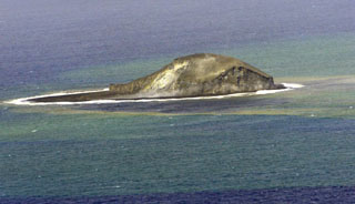
Home Reef
Tonga
18.992°S, 174.775°W; summit elev. -10 m
All times are local (unless otherwise noted)
Reports have been received of large pumice rafts in the Fiji Islands. On 16 September observers aboard the M/V National Geographic Endeavour noted almost continuous rows of pumice that day as they traveled about 90 km east-southeast to Vatoa Island, where the pumice was present on the beaches. Large rafts of pumice were also passing through the northern Lau Group around Naitauba Island on 19 September. The source of the pumice is unknown at this time. [Later determined to be from Home Reef.]
Geological Summary. Home Reef, a submarine volcano midway between Metis Shoal and Late Island in the central Tonga islands, was first reported active in the mid-19th century, when an ephemeral island formed. An eruption in 1984 produced a 12-km-high eruption plume, large amounts of floating pumice, and an ephemeral 500 x 1,500 m island, with cliffs 30-50 m high that enclosed a water-filled crater. In 2006 an island-forming eruption produced widespread dacitic pumice rafts that drifted as far as Australia. Another island was built during a September-October 2022 eruption.
Sources: David Cothran, M/V National Geographic Endeavour, David Forsythe, Naitauba Island, Fiji