Report on Lateiki (Tonga) — 18 October-24 October 2006
Smithsonian Institution / US Geological Survey
Weekly Volcanic Activity Report, 18 October-24 October 2006
Managing Editor: Sally Sennert.
Please cite this report as:
Global Volcanism Program, 2006. Report on Lateiki (Tonga) (Sennert, S, ed.). Weekly Volcanic Activity Report, 18 October-24 October 2006. Smithsonian Institution and US Geological Survey.
Lateiki
Tonga
19.18°S, 174.87°W; summit elev. 43 m
All times are local (unless otherwise noted)
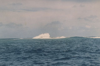
Further information obtained regarding the floating pumice rafts between Tonga and Fiji indicated that the source was Metis Shoal. Mariners in the region were being informed of this activity in early September via "Rag of the Air" radio broadcasts from Fiji. The earliest report found to this point comes from a boat with callsign KB1LSY, noting that "thick pumice" slowed them for 30 minutes during the early morning hours of 28 August as they were approaching the northern islands of the Lau Group in Fiji, about 500 km NW of Metis Shoal. By 15 October yachts sailing between Tonga and Fiji reported no remaining pumice.
Geological Summary. Lateiki, previously known as Metis Shoal, is a submarine volcano midway between the islands of Kao and Late that has produced a series of ephemeral islands since the first confirmed activity in the mid-19th century. An island, perhaps not in eruption, was reported in 1781 and subsequently eroded away. During periods of inactivity following 20th-century eruptions, waves have been observed to break on rocky reefs or sandy banks with depths of 10 m or less. Dacitic tuff cones formed during the eruptions in 1967 and 1979 were soon eroded beneath the ocean surface. An eruption in 1995 produced an island with a diameter of 280 m and a height of 43 m following growth of a lava dome above the surface.
Sources: Bob McDavitt's Pacific Weathergrams, KB1LSY Crew, Encore II Crew