Report on Ritter Island (Papua New Guinea) — 1 November-7 November 2006
Smithsonian Institution / US Geological Survey
Weekly Volcanic Activity Report, 1 November-7 November 2006
Managing Editor: Sally Sennert.
Please cite this report as:
Global Volcanism Program, 2006. Report on Ritter Island (Papua New Guinea) (Sennert, S, ed.). Weekly Volcanic Activity Report, 1 November-7 November 2006. Smithsonian Institution and US Geological Survey.
Ritter Island
Papua New Guinea
5.519°S, 148.115°E; summit elev. 75 m
All times are local (unless otherwise noted)
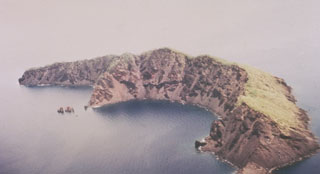
On 17 October, a villager from Kampalap (on the E coast of Siassi Island) reported unusual activity from Ritter Island to the RVO. The activity consisted of small felt earthquakes followed by emissions of white vapor and diffuse ash clouds. Rocks slid down the inner crater wall. Ashfall, which the observer indicated was not from Langila, was reported in Kampalap.
Geological Summary. Prior to 1888, Ritter Island was a steep-sided, nearly circular island about 780 m high between Umboi and Sakar Islands. Several historical explosive eruptions had been recorded prior to 1888, when large-scale slope failure destroyed the summit of the conical basaltic-andesitic volcano, leaving the arcuate 140-m-high island with a steep west-facing scarp. Devastating tsunamis were produced by the collapse and swept the coast of Papua New Guinea and offshore islands. Two minor post-collapse explosive eruptions, during 1972 and 1974, occurred offshore within the largely submarine 3.5 x 4.5 km breached depression formed by the collapse.
Source: Rabaul Volcano Observatory (RVO)