Report on Ritter Island (Papua New Guinea) — 23 May-29 May 2007
Smithsonian Institution / US Geological Survey
Weekly Volcanic Activity Report, 23 May-29 May 2007
Managing Editor: Sally Sennert.
Please cite this report as:
Global Volcanism Program, 2007. Report on Ritter Island (Papua New Guinea) (Sennert, S, ed.). Weekly Volcanic Activity Report, 23 May-29 May 2007. Smithsonian Institution and US Geological Survey.
Ritter Island
Papua New Guinea
5.519°S, 148.115°E; summit elev. 75 m
All times are local (unless otherwise noted)
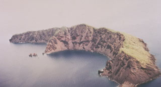
On 30 May, RVO reported observations of Ritter Island following reports of a possible eruption and "sea surges" that destroyed homes on 19 May. On the S part of the island, scorched vegetation was observed and dead marine life (mainly reef fish) was seen around the coast line at heights of 4-6 m a.s.l. There was no evidence of fresh volcanic material, but a new landslide scar extended from the upper most part of the island down to sea level. Several more landslide scars were seen on the W wall. The estimated wave surge height resulting from the 19 May event reached 4-10 m, particularly around the S part of the island. Rockfalls continued to produce plumes that could be seen from a distance.
Geological Summary. Prior to 1888, Ritter Island was a steep-sided, nearly circular island about 780 m high between Umboi and Sakar Islands. Several historical explosive eruptions had been recorded prior to 1888, when large-scale slope failure destroyed the summit of the conical basaltic-andesitic volcano, leaving the arcuate 140-m-high island with a steep west-facing scarp. Devastating tsunamis were produced by the collapse and swept the coast of Papua New Guinea and offshore islands. Two minor post-collapse explosive eruptions, during 1972 and 1974, occurred offshore within the largely submarine 3.5 x 4.5 km breached depression formed by the collapse.
Source: Rabaul Volcano Observatory (RVO)