Report on Dempo (Indonesia) — 18 March-24 March 2009
Smithsonian Institution / US Geological Survey
Weekly Volcanic Activity Report, 18 March-24 March 2009
Managing Editor: Sally Sennert.
Please cite this report as:
Global Volcanism Program, 2009. Report on Dempo (Indonesia) (Sennert, S, ed.). Weekly Volcanic Activity Report, 18 March-24 March 2009. Smithsonian Institution and US Geological Survey.
Dempo
Indonesia
4.016°S, 103.121°E; summit elev. 3142 m
All times are local (unless otherwise noted)
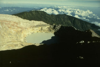
On 23 March, CVGHM lowered the Alert Level for Dempo from 2 to 1 (on a scale of 1-4) based on visual observations of the crater lake during 5-6 January and 2-4 March, and decreased seismicity since a phreatic eruption on 1 January. Visitors and residents were advised not to go within a 1-km radius of the summit.
Geological Summary. Dempo is a stratovolcano that rises above the Pasumah Plain of SE Sumatra. The andesitic complex has two main peaks, Gunung Dempo and Gunung Marapi, constructed near the SE rim of a 3-km-wide amphitheater open to the north. The high point of the older Gunung Dempo crater rim is slightly lower, and lies at the SE end of the summit complex. The taller Marapi cone was constructed within the older crater. Remnants of seven craters are found at or near the summit, with volcanism migrating WNW over time. The active 750 x 1,100 m active crater cuts the NW side of the Marapi cone and contains a 400-m-wide lake at the far NW end. Eruptions recorded since 1817 have been small-to-moderate explosions that produced local ashfall.
Source: Pusat Vulkanologi dan Mitigasi Bencana Geologi (PVMBG, also known as CVGHM)