Report on Tongariro (New Zealand) — 1 August-7 August 2012
Smithsonian Institution / US Geological Survey
Weekly Volcanic Activity Report, 1 August-7 August 2012
Managing Editor: Sally Sennert.
Please cite this report as:
Global Volcanism Program, 2012. Report on Tongariro (New Zealand) (Sennert, S, ed.). Weekly Volcanic Activity Report, 1 August-7 August 2012. Smithsonian Institution and US Geological Survey.
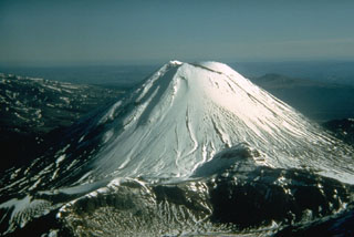
Tongariro
New Zealand
39.157°S, 175.632°E; summit elev. 1978 m
All times are local (unless otherwise noted)
On 6 August GeoNet reported that volcanic earthquakes continued beneath Tongariro but the size and number had decreased; there were fewer than five events each day. At about 2350 a short-lived (~1-2 minutes) phreatic eruption occurred at the Te Mari craters area, followed by a series of discrete small earthquakes over the next few tens of minutes. The Alert Level was raised to 2 (on a scale of 0-5) and the Aviation Colour Code was raised to Orange (second highest on a four-color scale). An ash plume drifted E and ashfall was reported in areas around the volcano. According to a news article, a GNS Science volcanologist noted that there were reports of "red hot rocks being thrown out of the crater", explosions, and lighting. The article also stated that some people in the Tongariro area had self-evacuated following the eruption. The Desert Road section of State Highway 1 (NE) had been closed due to poor visibility from the ash, and about 5 cm of ash had fallen on State Highway 46, to the N. Some flights to and from Gisborne (210 km ENE), Rotorua (120 NNE), Taupo (60 km NE), and Palmerston North (135 km S) were delayed or cancelled due to the eruption, and Hawke's Bay Airport (110 km ESE) had closed. GeoNet observed that no volcanic tremor occurred in the days preceding the eruption. The last eruption occurred in 1897. [Correction: The last eruption from the Te Mari craters area had occurred in 1896.]
On 7 August white steam clouds rose from the Te Mari craters area but poor weather conditions at the time obscured a direct view of the active vent(s). A few small earthquakes had been detected. A news article stated that alpine guides observed three active vents that appeared to be new.
Geological Summary. Tongariro is a large volcanic massif, located immediately NE of Ruapehu volcano, that is composed of more than a dozen composite cones constructed over a period of 275,000 years. Vents along a NE-trending zone extending from Saddle Cone (below Ruapehu) to Te Maari crater (including vents at the present-day location of Ngauruhoe) were active during several hundred years around 10,000 years ago, producing the largest known eruptions at the Tongariro complex during the Holocene. North Crater stratovolcano is truncated by a broad, shallow crater filled by a solidified lava lake that is cut on the NW side by a small explosion crater. The youngest cone, Ngauruhoe, is also the highest peak.