Report on Tongariro (New Zealand) — 26 September-2 October 2012
Smithsonian Institution / US Geological Survey
Weekly Volcanic Activity Report, 26 September-2 October 2012
Managing Editor: Sally Sennert.
Please cite this report as:
Global Volcanism Program, 2012. Report on Tongariro (New Zealand) (Sennert, S, ed.). Weekly Volcanic Activity Report, 26 September-2 October 2012. Smithsonian Institution and US Geological Survey.
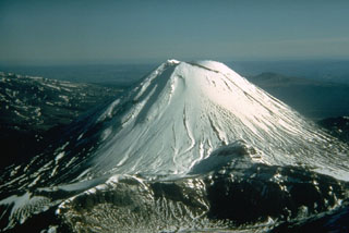
Tongariro
New Zealand
39.157°S, 175.632°E; summit elev. 1978 m
All times are local (unless otherwise noted)
The GeoNet Data Centre reported that researchers visited Tongariro's Upper Te Mari Craters on 30 September to sample several of the fumaroles, conduct a carbon dioxide soil gas survey, collect ejecta from the 6-7 August eruption, and photograph the area. They found that the average carbon dioxide soil gas flux was lower than the 27 July measurements; 24 sites had increased fluxes while 20 had decreased. The estimated soil gas emission has decreased from about 5.8 to 2.5 tonnes per day based on these measurements.
Geological Summary. Tongariro is a large volcanic massif, located immediately NE of Ruapehu volcano, that is composed of more than a dozen composite cones constructed over a period of 275,000 years. Vents along a NE-trending zone extending from Saddle Cone (below Ruapehu) to Te Maari crater (including vents at the present-day location of Ngauruhoe) were active during several hundred years around 10,000 years ago, producing the largest known eruptions at the Tongariro complex during the Holocene. North Crater stratovolcano is truncated by a broad, shallow crater filled by a solidified lava lake that is cut on the NW side by a small explosion crater. The youngest cone, Ngauruhoe, is also the highest peak.
Source: GeoNet