Report on Hekla (Iceland) — 20 March-26 March 2013
Smithsonian Institution / US Geological Survey
Weekly Volcanic Activity Report, 20 March-26 March 2013
Managing Editor: Sally Sennert.
Please cite this report as:
Global Volcanism Program, 2013. Report on Hekla (Iceland) (Sennert, S, ed.). Weekly Volcanic Activity Report, 20 March-26 March 2013. Smithsonian Institution and US Geological Survey.
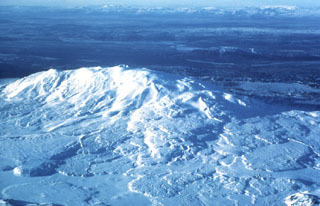
Hekla
Iceland
63.983°N, 19.666°W; summit elev. 1490 m
All times are local (unless otherwise noted)
The Icelandic Meteorological Office noted that since 10 March, at least seven micro-earthquakes at Hekla, ranging in size from M 0.4 to 1, had been detected within a small area about 4.5 km NE of the summit, at depths of 11-12 km. These earthquakes were high-frequency, suggestive of brittle fracturing rather than magma movement. At Hekla, such a clustering of earthquakes is unusual in between eruptions. Continuous measurements of borehole strain and ground-based GPS showed no changes in crustal deformation.
On 26 March the Icelandic Meteorological Office increased the Aviation Colour Code from Green to Yellow, because of the increased seismic activity. Icelandic Civil Defense together with the Police in Hvolsvöllur had also declared a level of uncertainty for Hekla, although there were no observable signs that an eruption of Hekla was imminent.
Geological Summary. One of Iceland's most prominent and active volcanoes, Hekla lies near the southern end of the eastern rift zone. Hekla occupies a rift-transform junction, and has produced basaltic andesites, in contrast to the tholeiitic basalts typical of Icelandic rift zone volcanoes. Vatnafjöll, a 40-km-long, 9-km-wide group of basaltic fissures and crater rows immediately SE of Hekla forms a part of the Hekla-Vatnafjöll volcanic system. A 5.5-km-long fissure, Heklugjá, cuts across the 1491-m-high Hekla volcano and is often active along its full length during major eruptions. Repeated eruptions along this rift, which is oblique to most rifting structures in the eastern volcanic zone, are responsible for Hekla's elongated ENE-WSW profile. Frequent large silicic explosive eruptions during historical time have deposited tephra throughout Iceland, providing valuable time markers used to date eruptions from other Icelandic volcanoes. Hekla tephras are generally rich in fluorine and are consequently very hazardous to grazing animals. Extensive lava flows from historical eruptions, which date back to 1104 CE, cover much of the volcano's flanks.
Sources: Icelandic Meteorological Office (IMO), Icelandic National Broadcasting Service (RUV)