Report on Tungurahua (Ecuador) — 24 April-30 April 2013
Smithsonian Institution / US Geological Survey
Weekly Volcanic Activity Report, 24 April-30 April 2013
Managing Editor: Sally Sennert.
Please cite this report as:
Global Volcanism Program, 2013. Report on Tungurahua (Ecuador) (Sennert, S, ed.). Weekly Volcanic Activity Report, 24 April-30 April 2013. Smithsonian Institution and US Geological Survey.
Tungurahua
Ecuador
1.467°S, 78.442°W; summit elev. 5023 m
All times are local (unless otherwise noted)
IG reported that during 24-26 April activity at Tungurahua was low. On 27 April seismic activity increased; an ash plume rose 2 km above the crater and drifted NW, causing ashfall in Juive (7 km NNW). During the morning on 28 April steam-and-ash plumes rose 1-4 km and drifted at least 100 km SW and W. Later that day several explosions produced ash plumes that rose as high as 3.5 km and drifted W. Ashfall was reported in Baños (8 km N), Chacauco (NW), Bilbao (8 km W), Cusúa (8 km NW), Juive, Pondoa (8 km N), and Pillate (8 km W). At 1830 a steam-and-ash plume rose 5 km, and drifted SW and then W. Another explosion ejected incandescent blocks that fell on the flanks 400 m below the crater. During breaks in cloud cover on 29 April dark gray emissions were observed drifting ESE. Ashfall was reported in El Manzano (8 km SW), Cahuají (8 km SW), Puela (8 km SW), Penipe (15 km SW), and Riobamba (30 km S). An explosion caused structures to vibrate. On 30 April explosions produced ash plumes that rose 1.5-2 km and drifted WSW.
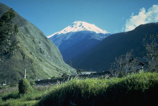
Geological Summary. Tungurahua, a steep-sided andesitic-dacitic stratovolcano that towers more than 3 km above its northern base, is one of Ecuador's most active volcanoes. Three major edifices have been sequentially constructed since the mid-Pleistocene over a basement of metamorphic rocks. Tungurahua II was built within the past 14,000 years following the collapse of the initial edifice. Tungurahua II collapsed about 3,000 years ago and produced a large debris-avalanche deposit to the west. The modern glacier-capped stratovolcano (Tungurahua III) was constructed within the landslide scarp. Historical eruptions have all originated from the summit crater, accompanied by strong explosions and sometimes by pyroclastic flows and lava flows that reached populated areas at the volcano's base. Prior to a long-term eruption beginning in 1999 that caused the temporary evacuation of the city of Baños at the foot of the volcano, the last major eruption had occurred from 1916 to 1918, although minor activity continued until 1925.
Source: Instituto Geofísico-Escuela Politécnica Nacional (IG-EPN)

