Report on Grimsvotn (Iceland) — 30 September-6 October 2015
Smithsonian Institution / US Geological Survey
Weekly Volcanic Activity Report, 30 September-6 October 2015
Managing Editor: Sally Sennert.
Please cite this report as:
Global Volcanism Program, 2015. Report on Grimsvotn (Iceland) (Sennert, S, ed.). Weekly Volcanic Activity Report, 30 September-6 October 2015. Smithsonian Institution and US Geological Survey.
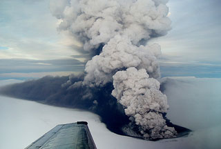
Grimsvotn
Iceland
64.416°N, 17.316°W; summit elev. 1719 m
All times are local (unless otherwise noted)
According to the Icelandic Meteorological Office, the water level of the Skaftá river at Sveinstindur (the closest gauging station at 28 km downstream from the ice margin) and electrical conductivity both rose on 29 September, indicating the beginning of a glacial outburst flood (jökulhlaup), originating from [the Eastern Skaftá ice cauldron, NW of Grímsvötn]. GPS measurements indicated that the ice surface above the lake began to subside late on 27 September; the rate progressively increased reflecting increased discharge from the lake.
At 0330 on 1 October the discharge rate detected at Sveinstindur was higher than 1,300 m³/s, the highest rate recorded since the station was established in 1971. At around 1000, floodwater was also detected in Skaftárdalur at a discharge rate of ~400 m³/s and was rising quickly. GPS data from the eastern ice cauldron showed over 66 m of subsidence since 1800 on 27 September. IMO warned that hydrogen sulfide released from the floodwater as it drains is particularly potent at the river outlet from the ice margin, where concentrations may reach poisonous levels. The cauldrons drain every two years on average, producing floods of up to 1,500 cubic meters per second. During fieldwork later that day volcanologists observed where the jökulhlaup had burst through the glacier at several locations 1-2 km from the terminus. Ice fragments a few tens of centimeters in diameter were scattered near the terminus; ice blocks 3-5 m high and 10 m long were deposited close to the outflow points.
On 2 October IMO noted that the jökulhlaup was possibly the largest to have occurred from the Skaftá cauldrons. The discharge rate peaked at 0200, just short of 2,100 m³/s, however true discharge rate was thought to have been considerably greater (3,000 m³/s) since water flooded outside of the gauged area. The discharge rate peaked at 1300 at Eldvatn near Ásar at an approximate rate of 2,200 m³/s. According to a news article, the high waters in the Skaftá River damaged the bridge over Eldvatn prompting authorities to close the bridge during 4-5 October.
Geological Summary. Grímsvötn, Iceland's most frequently active volcano in recent history, lies largely beneath the vast Vatnajökull icecap. The caldera lake is covered by a 200-m-thick ice shelf, and only the southern rim of the 6 x 8 km caldera is exposed. The geothermal area in the caldera causes frequent jökulhlaups (glacier outburst floods) when melting raises the water level high enough to lift its ice dam. Long NE-SW-trending fissure systems extend from the central volcano. The most prominent of these is the noted Laki (Skaftar) fissure, which extends to the SW and produced the world's largest known historical lava flow in 1783. The 15 km3 basaltic Laki lavas were erupted over 7 months from a 27-km-long fissure system. Extensive crop damage and livestock losses caused a severe famine that resulted in the loss of one-fifth of the population of Iceland.
Sources: Icelandic Meteorological Office (IMO), Iceland Magazine