Report on San Miguel (El Salvador) — 13 January-19 January 2016
Smithsonian Institution / US Geological Survey
Weekly Volcanic Activity Report, 13 January-19 January 2016
Managing Editor: Sally Sennert.
Please cite this report as:
Global Volcanism Program, 2016. Report on San Miguel (El Salvador) (Sennert, S, ed.). Weekly Volcanic Activity Report, 13 January-19 January 2016. Smithsonian Institution and US Geological Survey.
San Miguel
El Salvador
13.434°N, 88.269°W; summit elev. 2130 m
All times are local (unless otherwise noted)
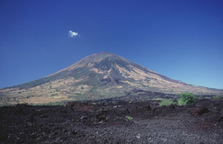
SNET reported that at 0520 on 12 January a gas-and-ash plume from San Miguel rose 400-800 m above the crater and drifted WSW, causing ashfall in San Jorge, Caseríos, La Piedra, Moritas, and La Placita. Gas-and-ash emissions continued through the rest of the day; ashfall was also later reported in San Rafael Oriente, Alegría, and Berlín en Usulután. Seismicity declined during 12-14 January. Gas plumes with minor to no ash content rose as high as 300 m. On 14 January seismicity stabilized above background levels, and gas emissions were observed. The next day local observers reported a millimeter of ash deposited in Las Cruces, on the N flank. A webcam recorded gas emissions rising 400 m and drifting N throughout the morning. Gas emissions during 17-18 January were weak, only rising 150 m, and RSAM values gradually declined. At 0900 on 18 January the emission plume became dark and drifted SW.
Geological Summary. The symmetrical cone of San Miguel, one of the most active volcanoes in El Salvador, rises from near sea level to form one of the country's most prominent landmarks. A broad, deep, crater complex that has been frequently modified by eruptions recorded since the early 16th century caps the truncated unvegetated summit, also known locally as Chaparrastique. Flanks eruptions of the basaltic-andesitic volcano have produced many lava flows, including several during the 17th-19th centuries that extended to the N, NE, and SE. The SE-flank flows are the largest and form broad, sparsely vegetated lava fields crossed by highways and a railroad skirting the base of the volcano. Flank vent locations have migrated higher on the edifice during historical time, and the most recent activity has consisted of minor ash eruptions from the summit crater.