Report on Rinjani (Indonesia) — 28 September-4 October 2016
Smithsonian Institution / US Geological Survey
Weekly Volcanic Activity Report, 28 September-4 October 2016
Managing Editor: Sally Sennert.
Please cite this report as:
Global Volcanism Program, 2016. Report on Rinjani (Indonesia) (Sennert, S, ed.). Weekly Volcanic Activity Report, 28 September-4 October 2016. Smithsonian Institution and US Geological Survey.
Rinjani
Indonesia
8.42°S, 116.47°E; summit elev. 3726 m
All times are local (unless otherwise noted)
Based on data from the Mount Rinjani National Park, BNPB reported that as many as 1,023 tourists were on Rinjani when it erupted on 27 September; officially only 464 people were registered to make the 3-day trek to the volcano and back. Officials began the evacuation of tourists that day. According to a news article, 44 trekkers had still not returned to the entrance points by 1 October. The Alert Level remained at 2 (on a scale of 1-4); the public was warned not to approach the crater within a 3-km radius.
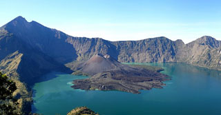
Geological Summary. Rinjani volcano on the island of Lombok rises to 3726 m, second in height among Indonesian volcanoes only to Sumatra's Kerinci volcano. Rinjani has a steep-sided conical profile when viewed from the east, but the west side of the compound volcano is truncated by the 6 x 8.5 km, oval-shaped Segara Anak (Samalas) caldera. The caldera formed during one of the largest Holocene eruptions globally in 1257 CE, which truncated Samalas stratovolcano. The western half of the caldera contains a 230-m-deep lake whose crescentic form results from growth of the post-caldera cone Barujari at the east end of the caldera. Historical eruptions dating back to 1847 have been restricted to Barujari cone and consist of moderate explosive activity and occasional lava flows that have entered Segara Anak lake.
Sources: Badan Nacional Penanggulangan Bencana (BNPB), The Jakarta Post, The Jakarta Post