Report on Banda Api (Indonesia) — 5 April-11 April 2017
Smithsonian Institution / US Geological Survey
Weekly Volcanic Activity Report, 5 April-11 April 2017
Managing Editor: Sally Sennert.
Please cite this report as:
Global Volcanism Program, 2017. Report on Banda Api (Indonesia) (Sennert, S, ed.). Weekly Volcanic Activity Report, 5 April-11 April 2017. Smithsonian Institution and US Geological Survey.
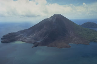
Banda Api
Indonesia
4.523°S, 129.881°E; summit elev. 596 m
All times are local (unless otherwise noted)
PVMBG reported that seismicity at Banda Api had been increasing since the beginning of March, though during 1-4 April seismic patterns were similar to those recorded before an eruption in 1988. The Alert Level was raised to 2 (on a scale of 1-4); visitors and residents were warned not to approach Banda Api within a 1-km radius of the summit area.
Geological Summary. The 3-km-wide island of Banda Api is the northern-most volcano in the Banda arc and has a long period of recorded observation because of its key location in the Portuguese and Dutch spice trade. The basaltic-to-rhyodacitic volcano is located in the SW corner of a mostly submerged 7 km caldera. At least two episodes of caldera formation are thought to have occurred, with the arcuate islands of Lonthor and Neira considered to be pre-caldera remnants. A conical peak rises to about 600 m at the center of the island. Eruptions have been recorded since 1586 CE, mostly consisting of Strombolian eruptions from the summit crater, but larger explosive eruptions have occurred and occasional lava flows have reached the coast.
Source: Pusat Vulkanologi dan Mitigasi Bencana Geologi (PVMBG, also known as CVGHM)