Report on Chiles-Cerro Negro (Colombia-Ecuador) — 31 July-6 August 2019
Smithsonian Institution / US Geological Survey
Weekly Volcanic Activity Report, 31 July-6 August 2019
Managing Editor: Sally Sennert.
Please cite this report as:
Global Volcanism Program, 2019. Report on Chiles-Cerro Negro (Colombia-Ecuador) (Sennert, S, ed.). Weekly Volcanic Activity Report, 31 July-6 August 2019. Smithsonian Institution and US Geological Survey.
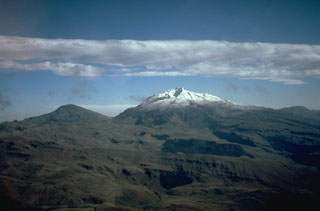
Chiles-Cerro Negro
Colombia-Ecuador
0.817°N, 77.938°W; summit elev. 4698 m
All times are local (unless otherwise noted)
Instituto Geofísico de la Escuela Politécnica Nacional (IGEPN) and the Observatorio Vulcanológico y Sismológico de Pasto del Servicio Geológico Colombiano (SGC OVSP) jointly reported that the most recent seismic swarm below Cerro Negro de Mayasquer and Chiles volcanoes began in September 2018 and continued at least through 1 August. The swarm has consisted of 147,000 earthquakes, recorded up to the time of the report publication, mostly with magnitudes less than 3.6. Notably, at least 91 very-long-period earthquakes and 89 long-period earthquakes have been detected, indicative of a magmatic body at depth. In addition, at 0738 on 25 July a M4 earthquake was located 4 km below the summit of Chiles and felt by residents. About 850 volcano-tectonic events were recorded during 25-28 July.
Geological Summary. The Chiles-Cerro Negro volcanic complex includes both the Pleistocene Chiles and the Cerro Negro de Mayasquer stratovolcanoes astride the Colombia-Ecuador border. Cerro Negro has a caldera open to the west, with andesitic and dacitic lava flows of possible Holocene age (Hall 1992, pers. comm.) and solfataras on the shore of a small crater lake. An eruption reported in 1936 may have been from Reventador (Catalog of Active Volcanoes of the World). The higher, glacier-covered summit of Chiles, about 4 km ESE of Cerro Negro, last erupted about 160,000 years ago, but it has a caldera open to the north with hot springs and an active hydrothermal system on its eastern flank.
Source: Instituto Geofísico-Escuela Politécnica Nacional (IG-EPN)