The Global Volcanism Program has no activity reports for Chaîne des Puys.
The Global Volcanism Program has no Weekly Reports available for Chaîne des Puys.
The Global Volcanism Program has no Bulletin Reports available for Chaîne des Puys.
This compilation of synonyms and subsidiary features may not be comprehensive. Features are organized into four major categories: Cones, Craters, Domes, and Thermal Features. Synonyms of features appear indented below the primary name. In some cases additional feature type, elevation, or location details are provided.
Synonyms |
||||
| Auvergne, Monts d' | ||||
Cones |
||||
| Feature Name | Feature Type | Elevation | Latitude | Longitude |
| Balmet, Puy | Cone | |||
| Bannieres, Puy des | Cone | 967 m | 45° 53' 0" N | 2° 57' 29" E |
| Barme, Puy de | Cone | 1102 m | 45° 44' 0" N | 2° 56' 0" E |
| Chalard, Puy | Cone | 840 m | 45° 58' 0" N | 2° 58' 30" E |
| Charmont, Puy de | Cone | 1138 m | 45° 41' 0" N | 2° 58' 0" E |
| Chaumont, Puy de | Cone | 1111 m | 45° 50' 0" N | 2° 58' 0" E |
| Combegrasse, Puy de | Cone | 1120 m | 45° 40' 0" N | 2° 57' 0" E |
| Come, Puy de | Cone | 1253 m | 45° 48' 0" N | 2° 57' 0" E |
| Coquille, Puy de la | Cone | 1152 m | 45° 50' 31" N | 2° 58' 0" E |
| Espinasse, Puy d' | Cone | 952 m | 45° 52' 30" N | 2° 57' 29" E |
| Fraisse, Puy de | Cone | 1120 m | 45° 48' 0" N | 2° 58' 0" E |
| Gonnard, Puy | Cone | 854 m | 45° 54' 0" N | 2° 58' 0" E |
| Goules, Puy de | Cone | 1146 m | 45° 49' 0" N | 2° 59' 0" E |
| Goulie, Puy de la | Cone | 944 m | 45° 52' 30" N | 2° 58' 0" E |
| Gouttes, Puy de | Cone | 1134 m | 45° 50' 0" N | 2° 57' 0" E |
| Grand Suchet, Le | Cone | 1231 m | 45° 47' 31" N | 2° 57' 0" E |
| Jumes, Puy de | Cone | 1161 m | 45° 51' 0" N | 2° 58' 0" E |
| Lantegy, Puy de | Cone | |||
| Laschamp, Puy de | Cone | 1255 m | 45° 44' 0" N | 2° 57' 0" E |
| Lassolas, Puy de | Cone | 1187 m | 45° 43' 0" N | 2° 57' 0" E |
| Louchadiere, Puy de | Cone | 1198 m | 45° 51' 0" N | 2° 57' 0" E |
| Mercoeur, Puy de | Cone | 1249 m | 45° 43' 0" N | 2° 57' 29" E |
| Mey, Puy de | Cone | 1136 m | 45° 43' 0" N | 2° 58' 0" E |
| Montchal, Puy de | Cone | 1094 m | 45° 42' 0" N | 2° 57' 0" E |
| Montchier, Puy | Cone | 1210 m | 45° 45' 0" N | 2° 57' 0" E |
| Montcineyre, Puy de | Cone | |||
| Montenard, Puy de | Cone | |||
| Montgy, Puy de | Cone | 1131 m | 45° 42' 0" N | 2° 56' 0" E |
| Montjugeat, Puy de | Cone | 1142 m | 45° 42' 0" N | 2° 57' 0" E |
| Nugere, Puy de la | Cone | 988 m | 45° 52' 0" N | 2° 59' 0" E |
| Pariou, Puy de | Cone | 1209 m | 45° 48' 0" N | 2° 58' 0" E |
| Paugnat, Puy de | Cone | 898 m | 45° 53' 0" N | 2° 59' 0" E |
| Pelat, Puy | Cone | 1208 m | 45° 43' 30" N | 2° 57' 0" E |
| Petit Puy de Dome | Cone | 1264 m | 45° 47' 0" N | 2° 58' 0" E |
| Petit Sarcoui | Cone | 1038 m | 45° 50' 0" N | 2° 59' 0" E |
| Poucharet, Puy de | Cone | 1164 m | 45° 43' 0" N | 2° 56' 0" E |
| Rodde, Puy de la | Cone | 1127 m | 45° 40' 0" N | 2° 57' 29" E |
| Tartaret | Cone | |||
| Taupe, Puy de la | Cone | 1074 m | 45° 41' 0" N | 2° 57' 0" E |
|
Tenusset, Puy de
Tunisset, Puy de |
Cone | 1056 m | 45° 51' 29" N | 2° 58' 0" E |
|
Thiolet, Puy
Verrieres, Puy de |
Cone | 937 m | 45° 54' 0" N | 2° 57' 0" E |
| Toupe, Puy de la | Cone | |||
|
Tressous, Puy de
Trois Sols, Puy des |
Cone | 983 m | 45° 52' 0" N | 2° 57' 0" E |
| Vache, Puy de la | Cone | 1167 m | 45° 42' 0" N | 2° 58' 0" E |
| Vichatel, Puy de | Cone | 1094 m | 45° 42' 0" N | 2° 58' 0" E |
Craters |
||||
| Feature Name | Feature Type | Elevation | Latitude | Longitude |
| Anchal, Maar d' | Maar | 750 m | ||
| Beauloup, Maar de | Maar | 840 m | 45° 50' 0" N | 2° 54' 0" E |
| Beaunit, Cratere de | Maar | 835 m | 45° 54' 0" N | 2° 58' 0" E |
| Ceyssat, Maar de | Maar | 860 m | 45° 46' 0" N | 2° 54' 0" E |
| Clermont Chamalieres | Maar | 390 m | 45° 47' 0" N | 3° 5' 0" E |
| Enval, Maar d' | Maar | 911 m | 45° 46' 0" N | 3° 0' 0" E |
| Estivadoux, Maar d' | Maar | |||
| Montchatre, Maar de | Maar | 920 m | 45° 48' 0" N | 3° 0' 0" E |
| Narse D'ampoix | Maar | 1050 m | 45° 40' 0" N | 2° 56' 0" E |
| Narse D'espinsasse | Maar | 1086 m | 45° 39' 0" N | 2° 56' 0" E |
| Pavin | Maar | |||
| Saint-Hippolyte, Cratere de | Maar | 501 m | 45° 54' 29" N | 3° 4' 0" E |
| Tazenat | Maar | 713 m | 45° 59' 0" N | 2° 59' 31" E |
| Villars, Maar de | Maar | 750 m | 45° 47' 0" N | 3° 2' 0" E |
| Volvic, Maar de | Maar | 732 m | 45° 52' 0" N | 3° 2' 0" E |
Domes |
||||
| Feature Name | Feature Type | Elevation | Latitude | Longitude |
| Chopine, Puy | Dome | 1181 m | 45° 50' 0" N | 2° 57' 0" E |
| Clierzou | Dome | 1197 m | 45° 48' 0" N | 2° 58' 0" E |
| Dome, Puy de | Dome | 840 m | 45° 46' 30" N | 2° 58' 0" E |
| Grand Sarcoui | Dome | 1147 m | 45° 49' 0" N | 2° 59' 0" E |
| Kilian Cratere | Dome | |||
|
l'Aumone, Puy de
Petit Suchet |
Dome | 1198 m | 45° 47' 31" N | 2° 58' 0" E |
| Vasset, Puy | Dome | |||
|
|
||||||||||||||||||||||||||
There is data available for 8 confirmed Holocene eruptive periods.
4040 BCE ± 150 years Confirmed Eruption
| Episode 1 | Eruption Episode | Montcineyre, Estivadoux, Pavin | |||||||||||||||||||||||||||||||||||||||
|---|---|---|---|---|---|---|---|---|---|---|---|---|---|---|---|---|---|---|---|---|---|---|---|---|---|---|---|---|---|---|---|---|---|---|---|---|---|---|---|---|
| 4040 BCE ± 150 years - Unknown | Evidence from Isotopic: 14C (uncalibrated) | |||||||||||||||||||||||||||||||||||||||
|
List of 6 Events for Episode 1 at Montcineyre, Estivadoux, Pavin
| ||||||||||||||||||||||||||||||||||||||||
5760 BCE (?) Confirmed Eruption
| Episode 1 | Eruption Episode | Puy de Come, Puy Montchier | |||||||||||||||||||
|---|---|---|---|---|---|---|---|---|---|---|---|---|---|---|---|---|---|---|---|---|
| 5760 BCE (?) - Unknown | Evidence from Radiogenic: Thermoluminescence | |||||||||||||||||||
|
List of 2 Events for Episode 1 at Puy de Come, Puy Montchier
| ||||||||||||||||||||
6020 BCE ± 150 years Confirmed Eruption
| Episode 1 | Eruption Episode | Puy de Lassolas, Puy de la Vache | ||||||||||||||||||||||||
|---|---|---|---|---|---|---|---|---|---|---|---|---|---|---|---|---|---|---|---|---|---|---|---|---|---|
| 6020 BCE ± 150 years - Unknown | Evidence from Isotopic: 14C (uncalibrated) | ||||||||||||||||||||||||
|
List of 3 Events for Episode 1 at Puy de Lassolas, Puy de la Vache
| |||||||||||||||||||||||||
6250 BCE (?) Confirmed Eruption
| Episode 1 | Eruption Episode | Puy de Pariou | |||||||||||||||||||||||||||||||||||||||||||||||||
|---|---|---|---|---|---|---|---|---|---|---|---|---|---|---|---|---|---|---|---|---|---|---|---|---|---|---|---|---|---|---|---|---|---|---|---|---|---|---|---|---|---|---|---|---|---|---|---|---|---|---|
| 6250 BCE (?) - Unknown | Evidence from Radiogenic: Thermoluminescence | |||||||||||||||||||||||||||||||||||||||||||||||||
|
List of 8 Events for Episode 1 at Puy de Pariou
| ||||||||||||||||||||||||||||||||||||||||||||||||||
6550 BCE (?) Confirmed Eruption
| Episode 1 | Eruption Episode | Puys Chopine, Vasset, Cratère Kilian | |||||||||||||||||||||||||||||
|---|---|---|---|---|---|---|---|---|---|---|---|---|---|---|---|---|---|---|---|---|---|---|---|---|---|---|---|---|---|---|
| 6550 BCE (?) - Unknown | Evidence from Isotopic: 14C (uncalibrated) | |||||||||||||||||||||||||||||
|
List of 4 Events for Episode 1 at Puys Chopine, Vasset, Cratère Kilian
| ||||||||||||||||||||||||||||||
7020 BCE ± 100 years Confirmed Eruption
| Episode 1 | Eruption Episode | Taphanel tephra | |||||||||||||||||||
|---|---|---|---|---|---|---|---|---|---|---|---|---|---|---|---|---|---|---|---|---|
| 7020 BCE ± 100 years - Unknown | Evidence from Isotopic: 14C (uncalibrated) | |||||||||||||||||||
|
List of 2 Events for Episode 1 at Taphanel tephra
| ||||||||||||||||||||
7740 BCE (?) Confirmed Eruption
| Episode 1 | Eruption Episode | Puy Mey | ||||||||||||||||||||||||
|---|---|---|---|---|---|---|---|---|---|---|---|---|---|---|---|---|---|---|---|---|---|---|---|---|---|
| 7740 BCE (?) - Unknown | Evidence from Radiogenic: Thermoluminescence | ||||||||||||||||||||||||
|
List of 3 Events for Episode 1 at Puy Mey
| |||||||||||||||||||||||||
7840 BCE ± 200 years Confirmed Eruption
| Episode 1 | Eruption Episode | Western Puy de Dôme | ||||||||||||||||||||||||
|---|---|---|---|---|---|---|---|---|---|---|---|---|---|---|---|---|---|---|---|---|---|---|---|---|---|
| 7840 BCE ± 200 years - Unknown | Evidence from Isotopic: 14C (uncalibrated) | ||||||||||||||||||||||||
|
List of 3 Events for Episode 1 at Western Puy de Dôme
| |||||||||||||||||||||||||
There is no Deformation History data available for Chaîne des Puys.
There is no Emissions History data available for Chaîne des Puys.
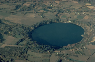 The Gour de Tazanet maar is the northernmost volcano of the Chaîne des Puys volcanic field in central France. The lake-filled explosion crater, one of many maars in the volcanic field, was formed when magma came in contact with groundwater. Rhythmic ejection of fragments of nonvolcanic rock produced bedded ash deposits and formed a low-rimmed crater, 700-m wide and 66-m deep.
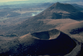 The Puy de Pariou cinder cone in the foreground and the Puy de Dôme lava dome in the background are part of a long N-S chain of volcanoes forming the Chaîne des Puy volcanic field in west-central France. The Puy de Pariou was formed about 8200 years ago inside a tuff ring from an earlier eruption whose rim can be seen at the lower right.
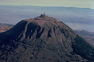 Puy de Dôme (1464 m), the highest peak of the Chaîne des Puys volcanic field, originated during a series of eruptions about 10,000 years ago. Explosive destruction of the eastern side of a massive lava dome, whose western face is seen in this photo, was followed by growth of a second dome. Crumbling of a spine capping the second dome formed the low mound of breccia at the summit of Puy de Dôme, which has been covered by a pyroclastic-flow deposit from nearby Killian volcano.
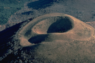 Puy de Dôme, in the France's Chaîne des Puys volcanic field, is a beautiful example of a nested pair of craters. The symmetrical crater at the summit of the cinder cone was formed by late-stage eruptions that built the small cone inside a larger crater rim produced by older eruptions.
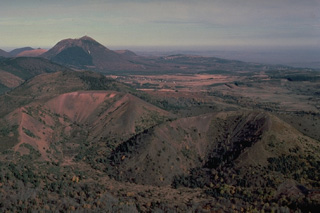 The twin breached cinder cones of Puy de Lassolas (left) and Puy de la Vache (right) were formed during eruptions about 8000 years ago. The cones were breached when moving lava flows carried away portions of them. A compound lava flow from the two cones traveled 14 km to the SE. The high peak in the distance to the north is the Puy de Dôme lava dome.
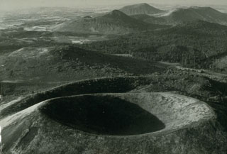 The Chaîne des Puys is a N-S-trending chain of cones, maars, and lava domes in the Auvergne region of France. The Puy de Pariou crater in the foreground is a tuff cone that grew about 8,200 years ago within an earlier tuff ring, whose rim appears immediately behind Pariou crater. A lava flow traveled 8 km W to near the present-day city of Clermont-Ferrand. The sharper peak in the background is Puy de Chopine, whose complex history ended with domal uplift.
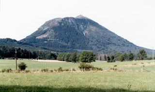 The southern flanks of Puy de Dôme, the highest peak of the Chaîne des Puys volcanic chain, rises above farmlands. Puy de Dôme originated during a series of eruptions about 10,000 years ago. Explosive destruction of the eastern side (right) of a massive lava dome was followed by growth of a second dome. Crumbling of a spine capping the second dome formed the low mound of breccia at the summit of Puy de Dôme, which has been covered by a pyroclastic flow deposit from nearby Killian volcano.
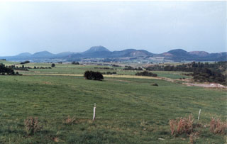 The central part of the Chaîne des Puys volcanic chain in the Auvergne region of France from the SW. Puy de Dôme is the rounded peak in the center, Puy de Côme is at the left, and Puy de Laschamp is the scoria cone at the right. The N-S-trending chain of basaltic and trachytic cones, basaltic maars, and trachytic lava domes in France's Massif Central has been active into the Holocene. The latest well-documented activity took place about 6,000 years ago.
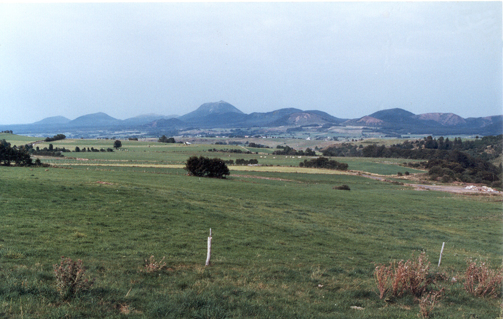
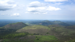 Part of the Chaîne des Puys volcanic field is shown in this May 2016 view from the Puy de Dome. The N-S trending volcanic chain includes around 80 lava domes, scoria cones, and maars, several of which are seen here.
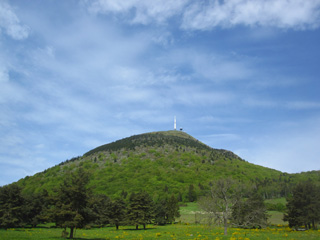 The 500-m-high Puy de Dôme of the Chaîne des Puys volcanic field formed around 11,000 years ago. The dome, with a diameter of 1.5-2 km, is surrounded by pyroclastic density current deposits.
The Global Volcanism Program has no maps available for Chaîne des Puys.
The following 3 samples associated with this volcano can be found in the Smithsonian's NMNH Department of Mineral Sciences collections, and may be availble for research (contact the Rock and Ore Collections Manager). Catalog number links will open a window with more information.
| Catalog Number | Sample Description | Lava Source | Collection Date |
|---|---|---|---|
| NMNH 116691-1 | Basalt Volcanic Bomb | -- | -- |
| NMNH 116691-1 | Basalt Volcanic Bomb | -- | -- |
| NMNH 60678 | Volcanic Bomb | -- | -- |
| Copernicus Browser | The Copernicus Browser replaced the Sentinel Hub Playground browser in 2023, to provide access to Earth observation archives from the Copernicus Data Space Ecosystem, the main distribution platform for data from the EU Copernicus missions. |
| MIROVA | Middle InfraRed Observation of Volcanic Activity (MIROVA) is a near real time volcanic hot-spot detection system based on the analysis of MODIS (Moderate Resolution Imaging Spectroradiometer) data. In particular, MIROVA uses the Middle InfraRed Radiation (MIR), measured over target volcanoes, in order to detect, locate and measure the heat radiation sourced from volcanic activity. |
| MODVOLC Thermal Alerts | Using infrared satellite Moderate Resolution Imaging Spectroradiometer (MODIS) data, scientists at the Hawai'i Institute of Geophysics and Planetology, University of Hawai'i, developed an automated system called MODVOLC to map thermal hot-spots in near real time. For each MODIS image, the algorithm automatically scans each 1 km pixel within it to check for high-temperature hot-spots. When one is found the date, time, location, and intensity are recorded. MODIS looks at every square km of the Earth every 48 hours, once during the day and once during the night, and the presence of two MODIS sensors in space allows at least four hot-spot observations every two days. Each day updated global maps are compiled to display the locations of all hot spots detected in the previous 24 hours. There is a drop-down list with volcano names which allow users to 'zoom-in' and examine the distribution of hot-spots at a variety of spatial scales. |
|
WOVOdat
Single Volcano View Temporal Evolution of Unrest Side by Side Volcanoes |
WOVOdat is a database of volcanic unrest; instrumentally and visually recorded changes in seismicity, ground deformation, gas emission, and other parameters from their normal baselines. It is sponsored by the World Organization of Volcano Observatories (WOVO) and presently hosted at the Earth Observatory of Singapore.
GVMID Data on Volcano Monitoring Infrastructure The Global Volcano Monitoring Infrastructure Database GVMID, is aimed at documenting and improving capabilities of volcano monitoring from the ground and space. GVMID should provide a snapshot and baseline view of the techniques and instrumentation that are in place at various volcanoes, which can be use by volcano observatories as reference to setup new monitoring system or improving networks at a specific volcano. These data will allow identification of what monitoring gaps exist, which can be then targeted by remote sensing infrastructure and future instrument deployments. |
| Volcanic Hazard Maps | The IAVCEI Commission on Volcanic Hazards and Risk has a Volcanic Hazard Maps database designed to serve as a resource for hazard mappers (or other interested parties) to explore how common issues in hazard map development have been addressed at different volcanoes, in different countries, for different hazards, and for different intended audiences. In addition to the comprehensive, searchable Volcanic Hazard Maps Database, this website contains information about diversity of volcanic hazard maps, illustrated using examples from the database. This site is for educational purposes related to volcanic hazard maps. Hazard maps found on this website should not be used for emergency purposes. For the most recent, official hazard map for a particular volcano, please seek out the proper institutional authorities on the matter. |
| IRIS seismic stations/networks | Incorporated Research Institutions for Seismology (IRIS) Data Services map showing the location of seismic stations from all available networks (permanent or temporary) within a radius of 0.18° (about 20 km at mid-latitudes) from the given location of Chaîne des Puys. Users can customize a variety of filters and options in the left panel. Note that if there are no stations are known the map will default to show the entire world with a "No data matched request" error notice. |
| UNAVCO GPS/GNSS stations | Geodetic Data Services map from UNAVCO showing the location of GPS/GNSS stations from all available networks (permanent or temporary) within a radius of 20 km from the given location of Chaîne des Puys. Users can customize the data search based on station or network names, location, and time window. Requires Adobe Flash Player. |
| DECADE Data | The DECADE portal, still in the developmental stage, serves as an example of the proposed interoperability between The Smithsonian Institution's Global Volcanism Program, the Mapping Gas Emissions (MaGa) Database, and the EarthChem Geochemical Portal. The Deep Earth Carbon Degassing (DECADE) initiative seeks to use new and established technologies to determine accurate global fluxes of volcanic CO2 to the atmosphere, but installing CO2 monitoring networks on 20 of the world's 150 most actively degassing volcanoes. The group uses related laboratory-based studies (direct gas sampling and analysis, melt inclusions) to provide new data for direct degassing of deep earth carbon to the atmosphere. |
| Large Eruptions of Chaîne des Puys | Information about large Quaternary eruptions (VEI >= 4) is cataloged in the Large Magnitude Explosive Volcanic Eruptions (LaMEVE) database of the Volcano Global Risk Identification and Analysis Project (VOGRIPA). |
| EarthChem | EarthChem develops and maintains databases, software, and services that support the preservation, discovery, access and analysis of geochemical data, and facilitate their integration with the broad array of other available earth science parameters. EarthChem is operated by a joint team of disciplinary scientists, data scientists, data managers and information technology developers who are part of the NSF-funded data facility Integrated Earth Data Applications (IEDA). IEDA is a collaborative effort of EarthChem and the Marine Geoscience Data System (MGDS). |

