The Global Volcanism Program has no activity reports for Corbetti.
The Global Volcanism Program has no Weekly Reports available for Corbetti.
The Global Volcanism Program has no Bulletin Reports available for Corbetti.
This compilation of synonyms and subsidiary features may not be comprehensive. Features are organized into four major categories: Cones, Craters, Domes, and Thermal Features. Synonyms of features appear indented below the primary name. In some cases additional feature type, elevation, or location details are provided.
Synonyms |
||||
| Tchobbe | Djabi | ||||
Cones |
||||
| Feature Name | Feature Type | Elevation | Latitude | Longitude |
| Artu | Cone | 1973 m | 7° 13' 9" N | 38° 24' 31" E |
| Biftu Tuff Cone | Cone | 1845 m | 7° 8' 42" N | 38° 27' 10" E |
|
Chabbi
Chebbi |
Cone | 2289 m | 7° 10' 54" N | 38° 26' 9" E |
| Urji | Cone | 2191 m | 7° 11' 34" N | 38° 22' 8" E |
| Wendo Koshe | Cone | 2214 m | 7° 11' 48" N | 38° 22' 38" E |
Craters |
||||
| Feature Name | Feature Type | Elevation | Latitude | Longitude |
| Corbetti | Caldera | 1725 m | 7° 9' 30" N | 38° 24' 30" E |
|
Hawasa
Awasa |
Pleistocene caldera | 1675 m | 7° 5' 0" N | 38° 27' 0" E |
|
|
||||||||||||||||||||||||
There is data available for 2 confirmed Holocene eruptive periods.
[ 1957 Jul 2 ± 182 days - 1964 Jul 2 ± 182 days ] Discredited Eruption
BVE included reports of copious fumarolic activity during 1957-1964 associated with very fresh obsidian flows. However, Wood (1978) noted that there was only Fumarolic activity, and the obsidian flows were much older.
0396 BCE ± 38 years Confirmed Eruption Max VEI: 5
| Episode 1 | Eruption Episode | Wendo Koshe Younger Pumice | ||||||||||||||||||||||||
|---|---|---|---|---|---|---|---|---|---|---|---|---|---|---|---|---|---|---|---|---|---|---|---|---|---|
| 0396 BCE ± 38 years - Unknown | Evidence from Isotopic: 14C (calibrated) | ||||||||||||||||||||||||
| The Wendo Koshe Younger Pumice is described by Rapprich et al. (2016) as follows: "The Plinian eruption of the Wendo Koshe crater within the Corbetti Caldera occurred around 396 BC. The pumice lapilli deposit, with a thickness exceeding 10 cm, dispersed over an area of over 1000 km2 around the towns of Hawasa and Shashemene. Most of the pumice was deposited by fall-out; however, minor local pyroclastic density currents also occurred. The calculated volume of preserved pumice fall deposit (approximately 1.2 km3), combined with the estimated volume of dispersed fine ash distributed further from the volcano, corresponds to an estimated volume of 0.4 km3 (dense rock equivalent) of erupted magma. The age of the pumice eruption (396 ± 38 BC) was determined by 14C radiometric dating of a paleosoil that developed on previous pyroclastic deposits buried by the pumice." | |||||||||||||||||||||||||
|
List of 3 Events for Episode 1 at Wendo Koshe Younger Pumice
| |||||||||||||||||||||||||
5425 BCE (in or before) ± 54 years Confirmed Eruption
| Episode 1 | Eruption Episode | Biftu Tuff Cone | ||||||||||||||||||||||||
|---|---|---|---|---|---|---|---|---|---|---|---|---|---|---|---|---|---|---|---|---|---|---|---|---|---|
| 5425 BCE (in or before) ± 54 years - Unknown | Evidence from Isotopic: 14C (calibrated) | ||||||||||||||||||||||||
| Research by Colby et al. (2022) "...constrained the age of the Biftu Tuff Cone eruption to <7375 ± 54 cal BP through 14C dating of shells incorporated into an associated PDC deposit. Carbon and oxygen isotope data from these shells also indicate the eruption likely occurred during a high-stand period at Lake Hawassa, raising the possibility of the lake water interacting with the eruption, resulting in the generation of the large-scale dilute PDCs observed." | |||||||||||||||||||||||||
|
List of 3 Events for Episode 1 at Biftu Tuff Cone
| |||||||||||||||||||||||||
There is data available for 3 deformation periods. Expand each entry for additional details.
| Start Date: 2009 | Stop Date: 2009 | Direction: Uplift | Method: InSAR |
| Magnitude: 4.000 cm | Spatial Extent: Unknown | Latitude: Unknown | Longitude: Unknown |
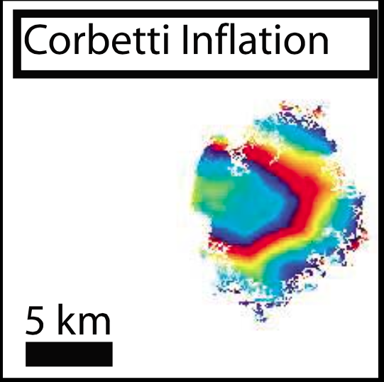 |
Corbetti inflation. Each fringe represents 2.8 cm of deformation. From: Biggs et al. 2011. |
||
Reference List: Biggs et al. 2011.
Full References:
Biggs J, Bastow I D, Keir D, Lewi E, 2011. Pulses of deformation reveal frequently recurring shallow magmatic activity beneath the Main Ethiopian Rift. Geochemistry Geophysics Geosystems, 12, Q0AB10. https://doi.org/10.1029/2011GC003662
| Start Date: 1997 | Stop Date: 2000 | Direction: Subsidence | Method: InSAR |
| Magnitude: 14.000 cm | Spatial Extent: Unknown | Latitude: Unknown | Longitude: Unknown |
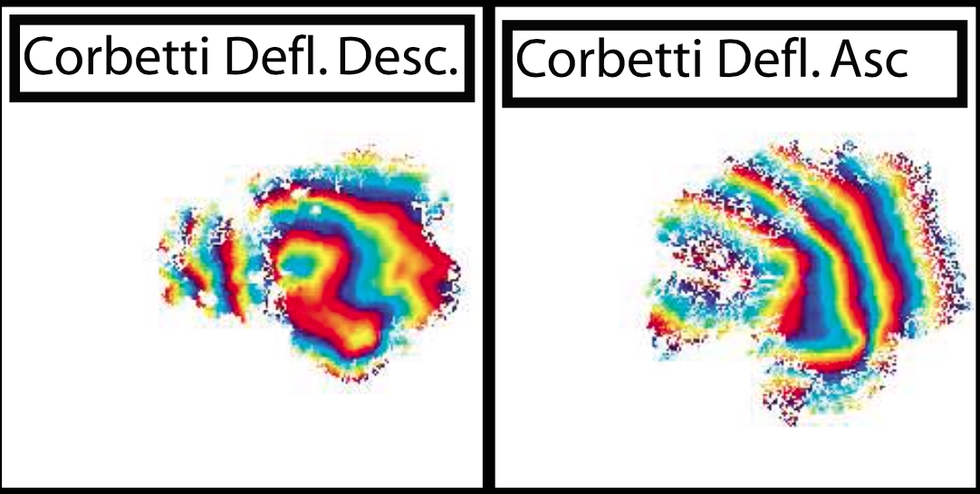 |
Corbetti deflation (Desc), 23 September 1997 to 13 September 2000; Corbetti deflation (Asc), 28 September 1997 to 17 September 2000. Each fringe represents 2.8 cm of deformation. From: Biggs et al. 2011. |
||
Reference List: Biggs et al. 2011.
Full References:
Biggs J, Bastow I D, Keir D, Lewi E, 2011. Pulses of deformation reveal frequently recurring shallow magmatic activity beneath the Main Ethiopian Rift. Geochemistry Geophysics Geosystems, 12, Q0AB10. https://doi.org/10.1029/2011GC003662
| Start Date: 1994 | Stop Date: 1996 | Direction: Uplift | Method: InSAR |
| Magnitude: Unknown | Spatial Extent: Unknown | Latitude: Unknown | Longitude: Unknown |
Reference List: Biggs et al. 2011.
Full References:
Biggs J, Bastow I D, Keir D, Lewi E, 2011. Pulses of deformation reveal frequently recurring shallow magmatic activity beneath the Main Ethiopian Rift. Geochemistry Geophysics Geosystems, 12, Q0AB10. https://doi.org/10.1029/2011GC003662
There is no Emissions History data available for Corbetti.
The maps shown below have been scanned from the GVP map archives and include the volcano on this page. Clicking on the small images will load the full 300 dpi map. Very small-scale maps (such as world maps) are not included. The maps database originated over 30 years ago, but was only recently updated and connected to our main database. We welcome users to tell us if they see incorrect information or other problems with the maps; please use the Contact GVP link at the bottom of the page to send us email.
There are no samples for Corbetti in the Smithsonian's NMNH Department of Mineral Sciences Rock and Ore collection.
| Copernicus Browser | The Copernicus Browser replaced the Sentinel Hub Playground browser in 2023, to provide access to Earth observation archives from the Copernicus Data Space Ecosystem, the main distribution platform for data from the EU Copernicus missions. |
| MIROVA | Middle InfraRed Observation of Volcanic Activity (MIROVA) is a near real time volcanic hot-spot detection system based on the analysis of MODIS (Moderate Resolution Imaging Spectroradiometer) data. In particular, MIROVA uses the Middle InfraRed Radiation (MIR), measured over target volcanoes, in order to detect, locate and measure the heat radiation sourced from volcanic activity. |
| MODVOLC Thermal Alerts | Using infrared satellite Moderate Resolution Imaging Spectroradiometer (MODIS) data, scientists at the Hawai'i Institute of Geophysics and Planetology, University of Hawai'i, developed an automated system called MODVOLC to map thermal hot-spots in near real time. For each MODIS image, the algorithm automatically scans each 1 km pixel within it to check for high-temperature hot-spots. When one is found the date, time, location, and intensity are recorded. MODIS looks at every square km of the Earth every 48 hours, once during the day and once during the night, and the presence of two MODIS sensors in space allows at least four hot-spot observations every two days. Each day updated global maps are compiled to display the locations of all hot spots detected in the previous 24 hours. There is a drop-down list with volcano names which allow users to 'zoom-in' and examine the distribution of hot-spots at a variety of spatial scales. |
|
WOVOdat
Single Volcano View Temporal Evolution of Unrest Side by Side Volcanoes |
WOVOdat is a database of volcanic unrest; instrumentally and visually recorded changes in seismicity, ground deformation, gas emission, and other parameters from their normal baselines. It is sponsored by the World Organization of Volcano Observatories (WOVO) and presently hosted at the Earth Observatory of Singapore.
GVMID Data on Volcano Monitoring Infrastructure The Global Volcano Monitoring Infrastructure Database GVMID, is aimed at documenting and improving capabilities of volcano monitoring from the ground and space. GVMID should provide a snapshot and baseline view of the techniques and instrumentation that are in place at various volcanoes, which can be use by volcano observatories as reference to setup new monitoring system or improving networks at a specific volcano. These data will allow identification of what monitoring gaps exist, which can be then targeted by remote sensing infrastructure and future instrument deployments. |
| Volcanic Hazard Maps | The IAVCEI Commission on Volcanic Hazards and Risk has a Volcanic Hazard Maps database designed to serve as a resource for hazard mappers (or other interested parties) to explore how common issues in hazard map development have been addressed at different volcanoes, in different countries, for different hazards, and for different intended audiences. In addition to the comprehensive, searchable Volcanic Hazard Maps Database, this website contains information about diversity of volcanic hazard maps, illustrated using examples from the database. This site is for educational purposes related to volcanic hazard maps. Hazard maps found on this website should not be used for emergency purposes. For the most recent, official hazard map for a particular volcano, please seek out the proper institutional authorities on the matter. |
| IRIS seismic stations/networks | Incorporated Research Institutions for Seismology (IRIS) Data Services map showing the location of seismic stations from all available networks (permanent or temporary) within a radius of 0.18° (about 20 km at mid-latitudes) from the given location of Corbetti. Users can customize a variety of filters and options in the left panel. Note that if there are no stations are known the map will default to show the entire world with a "No data matched request" error notice. |
| UNAVCO GPS/GNSS stations | Geodetic Data Services map from UNAVCO showing the location of GPS/GNSS stations from all available networks (permanent or temporary) within a radius of 20 km from the given location of Corbetti. Users can customize the data search based on station or network names, location, and time window. Requires Adobe Flash Player. |
| DECADE Data | The DECADE portal, still in the developmental stage, serves as an example of the proposed interoperability between The Smithsonian Institution's Global Volcanism Program, the Mapping Gas Emissions (MaGa) Database, and the EarthChem Geochemical Portal. The Deep Earth Carbon Degassing (DECADE) initiative seeks to use new and established technologies to determine accurate global fluxes of volcanic CO2 to the atmosphere, but installing CO2 monitoring networks on 20 of the world's 150 most actively degassing volcanoes. The group uses related laboratory-based studies (direct gas sampling and analysis, melt inclusions) to provide new data for direct degassing of deep earth carbon to the atmosphere. |
| Large Eruptions of Corbetti | Information about large Quaternary eruptions (VEI >= 4) is cataloged in the Large Magnitude Explosive Volcanic Eruptions (LaMEVE) database of the Volcano Global Risk Identification and Analysis Project (VOGRIPA). |
| EarthChem | EarthChem develops and maintains databases, software, and services that support the preservation, discovery, access and analysis of geochemical data, and facilitate their integration with the broad array of other available earth science parameters. EarthChem is operated by a joint team of disciplinary scientists, data scientists, data managers and information technology developers who are part of the NSF-funded data facility Integrated Earth Data Applications (IEDA). IEDA is a collaborative effort of EarthChem and the Marine Geoscience Data System (MGDS). |


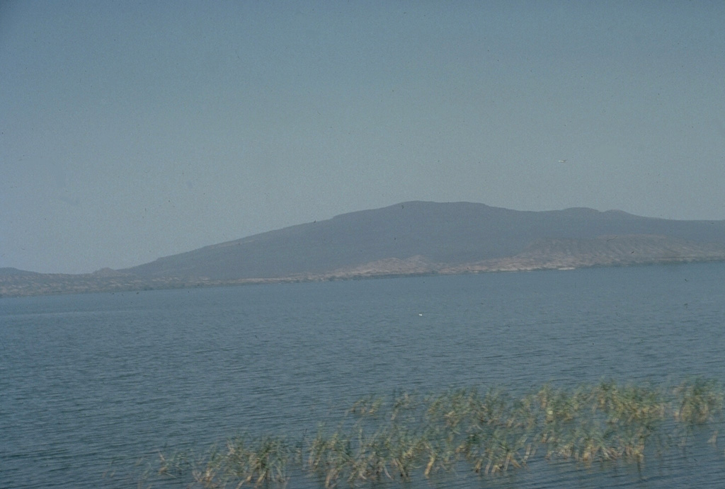
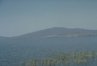 Chebbi volcano, rising to the N across Awasa lake, is a large obsidian dome constructed on the SE rim of the 15-km-wide Corbetti caldera, which itself lies within the NW side of the larger Awasa caldera. Lava flows extend into the caldera itself; the southern rim forms the low saddle to the left. The age of the latest eruption of Corbetti is not known, although fumarolic activity continues.