Webcam images of Dempo posted in the daily PVMBG reports showed possible patches of discolored water or material floating on the surface of the crater lake during 27-29 August. The Aviation Color Code was raised to Orange (the third color on a four-color scale). The Alert Level remained at 2 (on a scale of 1-4), and the public were reminded to stay 1 km away from the crater and as far as 2 km on the N flank.
Source: Pusat Vulkanologi dan Mitigasi Bencana Geologi (PVMBG, also known as CVGHM)
Phreatic explosion on 31 May 2022
The Dempo stratovolcano in SE Sumatra, Indonesia, has had many small explosive eruptions reported since 1817. The active Marapi crater (750 x 1,100 m) in the summit area contains a 400-m-wide crater lake (figure 7). Recent activity has consisted of single-day phreatic explosions in September 2006, January 2009, and November 2017. Indonesian’s Center of Volcanology and Geological Hazard Mitigation (CVGHM), also known as Pusat Vulkanologi dan Mitigasi Bencana Geologi (PVMBG), is the monitoring agency.
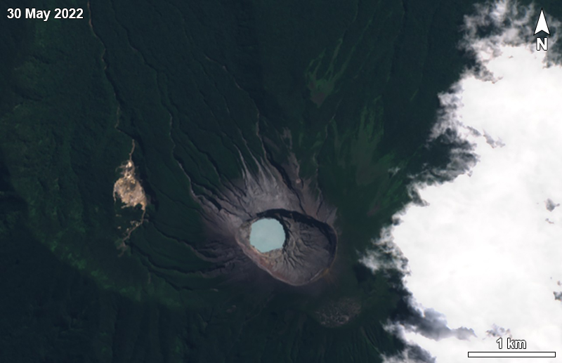 |
Figure 7. Satellite image of Dempo on 30 May 2022, showing the 400-m-wide crater lake within the Marapi summit crater. Sentinel-2 image with natural color rendering (bands 4, 3, 2). Courtesy of Sentinel Hub Playground. |
PVMBG reported phreatic explosion similar to those of recent years at 0154 on 31 May 2022. This event lasted 239 seconds and produced ashfall in areas within 5 km, including Pagar Alam Utara district (E) and North Dempo District; ash deposits were as thick as 1 mm. The Alert Level remained at 2 (on a scale of 1-4), and the public were reminded to stay 1 km away from the crater and as far as 2 km on the N flank.
Information Contacts: Pusat Vulkanologi dan Mitigasi Bencana Geologi (PVMBG, also known as Indonesian Center for Volcanology and Geological Hazard Mitigation, CVGHM), Jalan Diponegoro 57, Bandung 40122, Indonesia (URL: http://www.vsi.esdm.go.id/); Sentinel Hub Playground (URL: https://www.sentinel-hub.com/explore/sentinel-playground).
2023: July
| August
2022: May
2017: April
| November
2015: April
| September
2009: March
2008: December
2006: September
Webcam images of Dempo posted in the daily PVMBG reports showed possible patches of discolored water or material floating on the surface of the crater lake during 27-29 August. The Aviation Color Code was raised to Orange (the third color on a four-color scale). The Alert Level remained at 2 (on a scale of 1-4), and the public were reminded to stay 1 km away from the crater and as far as 2 km on the N flank.
Source: Pusat Vulkanologi dan Mitigasi Bencana Geologi (PVMBG, also known as CVGHM)
PVMBG reported that an eruption at Dempo occurred at 2105 on 21 August, but no ash emissions were observed. A video posted on social media showed a Surtseyan eruption through the crater lake, with steam plumes and dark material being ejected above the lake. The Aviation Color Code was raised to Orange (the third color on a four-color scale). The Alert Level remained at 2 (on a scale of 1-4), and the public were reminded to stay 1 km away from the crater and as far as 2 km on the N flank.
Sources: Pusat Vulkanologi dan Mitigasi Bencana Geologi (PVMBG, also known as CVGHM); Tribun Sumsel
PVMBG reported that the eruption at Dempo continued during 26 July-1 August. An ash plume at 2215 on 26 July rose 2 km (6,400 ft) above the summit crater and drifted S and SW, based on ground observations. The Alert Level remained at 2 (on a scale of 1-4), and the public were reminded to stay 1 km away from the crater and as far as 2 km on the N flank.
Source: Pusat Vulkanologi dan Mitigasi Bencana Geologi (PVMBG, also known as CVGHM)
PVMBG reported that at 2115 on 25 July an eruption at Dempo produced a white-and-gray ash plume that rose at least 2 km above the summit and drifted S and SW. An eruptive event was recorded at 1547 on 26 July but weather conditions prevented views of the volcano. At 2115 PVMBG issued a Volcano Observatory Notice for Aviation (VONA) stating that activity was increasing. The Alert Level remained at 2 (on a scale of 1-4), and the public were reminded to stay 1 km away from the crater and as far as 2 km on the N flank.
Source: Pusat Vulkanologi dan Mitigasi Bencana Geologi (PVMBG, also known as CVGHM)
PVMBG reported that at 0154 on 31 May a phreatic eruption at Dempo produced ashfall in areas within 5 km, including Pagar Alam Utara district (E) and North Dempo District. Ash deposits were as thick as 1 mm. The Alert Level remained at 2 (on a scale of 1-4), and the public were reminded to stay 1 km away from the crater and as far as 2 km on the N flank.
Source: Pusat Vulkanologi dan Mitigasi Bencana Geologi (PVMBG, also known as CVGHM)
According to PVMBG a three-minute-long phreatic eruption at Dempo began at 1651 on 9 November, and generated a dense ash plume that rose 4.2 km (13,800 ft) a.s.l., about 1 km above the crater rim, and drifted S. The Alert Level remained at 2 (on a scale of 1-4).
Source: Pusat Vulkanologi dan Mitigasi Bencana Geologi (PVMBG, also known as CVGHM)
Observers at the PVMBG Dempo observation post reported that during January and February no plumes rose from Dempo's crater, and during 1 March-4 April diffuse white plumes rose no higher than 50 m above the crater. Seismicity increased from 21 March to 4 April. The Alert Level was raised to 2 (on a scale from 1-4) on 5 April. Visitors and residents were advised not to approach the craters within 3 km.
Source: Pusat Vulkanologi dan Mitigasi Bencana Geologi (PVMBG, also known as CVGHM)
Observers at the PVMBG Dempo observation post reported that during 1 June-9 September no plumes rose from Dempo's crater and seismicity was low. On 10 September the Alert Level was lowered to 1 (on a scale from 1-4). Visitors and residents were advised not to approach the craters.
Source: Pusat Vulkanologi dan Mitigasi Bencana Geologi (PVMBG, also known as CVGHM)
Observers at the PVMBG Dempo observation post reported that during 0730-0900 on 27 April diffuse gray-white plumes rose 50 m above Dempo crater. Seismicity had increased during April as compared to the previous month. On 29 April the Alert Level was raised to 2 (on a scale from 1-4). Visitors and residents were advised not to go within a 1-km radius of the summit.
Source: Pusat Vulkanologi dan Mitigasi Bencana Geologi (PVMBG, also known as CVGHM)
On 23 March, CVGHM lowered the Alert Level for Dempo from 2 to 1 (on a scale of 1-4) based on visual observations of the crater lake during 5-6 January and 2-4 March, and decreased seismicity since a phreatic eruption on 1 January. Visitors and residents were advised not to go within a 1-km radius of the summit.
Source: Pusat Vulkanologi dan Mitigasi Bencana Geologi (PVMBG, also known as CVGHM)
CVGHM reported that on 1 January, a phreatic eruption from Dempo resulted in a strong sulfur odor and "ash rain" that was noted as far as about 10 km from the summit. Fog prevented direct observations of the summit. The Alert Level was raised to 2 (on a scale from 1-4). Visitors and residents were advised not to go within a 2-km radius of the summit.
Source: Pusat Vulkanologi dan Mitigasi Bencana Geologi (PVMBG, also known as CVGHM)
Increased seismicity at Dempo resulted in an elevation of the hazard status to Alert Level 2.
Source: Pusat Vulkanologi dan Mitigasi Bencana Geologi (PVMBG, also known as CVGHM)
Reports are organized chronologically and indexed below by Month/Year (Publication Volume:Number), and include a one-line summary. Click on the index link or scroll down to read the reports.
Earthquakes 18-19 September increase alert status
At 1810 on 18 September an earthquake was felt in an area around Dempo. The Volcanological Survey of Indonesia (VSI) reported its Modified Mercalli (MM) Intensity as MM IV. The following day three more earthquakes were felt: the first event took place at 0900 (MM II), the next at 1155 (MM I), and the last at 1800 (MM I). Recorded seismicity during these days indicated 30 events/day with amplitudes of 20-30 mm and arrival time differences (S-P) of 2-3 seconds on average. Volcanologists took this to mean that the earthquakes were local tectonic events. No visible signs of changed activity were apparent at the crater. The VSI took the precaution of increasing the condition of alert to Level II.
Information Contacts: Volcanological Survey of Indonesia (VSI), Jalan Diponegoro No. 57, Bandung 40122, Indonesia (URL: http://www.vsi.esdm.go.id/).
Sudden phreatic eruption on 1 January 2009
According to a report by Indonesia's Center of Volcanology and Geological Hazard Mitigation (CVGHM), Dempo had a phreatic eruption on 1 January 2009. The event resulted in a strong sulfur odor and an ash (or cinder) rain that was noted as far as ~ 10 km from the summit. During 27 December 2008 to 1 January 2009, fog prevented direct observations of the summit; clouds over the summit area are a common occurrence. The one available photo of the eruption showed a whitish-colored plume rising perhaps a few kilometers over the summit.
On 1 January authorities raised the alert status from 1 (normal) to 2 (alert, "Waspada" in Indonesian), on a scale that ranges from 1-4. Visitors and residents were advised not to go within a 2-km radius of the summit. A 2 January report from CVGHM noted that both local volcanic and regional tectonic earthquakes were recorded during 27 December 2008 through 1 January 2009 (table 1).
Table 1. Highlights of Dempo seismicity recorded during 27 December 2008 to 1 January 2009. Courtesy of CVGHM.
| Date | Seismicity |
| 27 Dec 2008 | One local volcanic (A-type), and two tectonic. |
| 28 Dec 2008 | One local volcanic (A-type), and one air blast event. |
| 29 Dec 2008 | One local volcanic, five air blasts, and two tectonic. |
| 30 Dec 2008 | One shallow local volcanic, one air blast, one low-frequency, and one tectonic. |
| 31 Dec 2008 | One local volcanic, one air blast, and two tectonic not at the volcano. |
| 01 Jan 2009 | One local volcanic related to the explosive eruption. |
As of early 2009, no thermal anomalies had been measured over Dempo by the MODVOLC infrared satellite system for at least the last 5 years. ASTER images from 2001-2007 show extensive cloud cover.
Information Contacts: Center of Volcanology and Geological Hazard Mitigation (CVGHM), Jalan Diponegoro 57, Bandung 40122, Indonesia (URL: http://vsi.esdm.go.id/); Hawai'i Institute of Geophysics and Planetology (HIGP) Thermal Alerts System, School of Ocean and Earth Science and Technology (SOEST), Univ. of Hawai'i, 2525 Correa Road, Honolulu, HI 96822, USA (URL: http://modis.higp.hawaii.edu/).
Phreatic eruption in September 2006 sent mud 300 m
Our most recent report on Dempo (BGVN 34:01) discussed a phreatic eruption on 1 January 2009. This eruption prompted Indonesia's Center of Volcanology and Geological Hazard Mitigation (CVGHM) to raise the alert level from 1 (normal) to 2 (alert) on a scale of 1-4. A few months later, on 23 March 2009, the CVGHM lowered Dempo's Alert Level to 1, based on visual observations of the crater lake during 5-6 January and 2-4 March, and decreased seismicity since the 1 January phreatic eruption.
The name Dempo applies to both the larger complex and to a peak that sits adjacent to a neighboring peak called Marapi. The latter volcano name applies to several different volcanoes in Indonesia and is easily confused with the very prominent volcano Merapi (central Java). The Marapi cone in the Dempo complex contains a ~ 400 m diameter crater lake, the source of both the 2006 and 2009 eruptions.
The remainder of this report discusses the phreatic eruption that occurred in September 2006. This eruption had not been previously discussed in the Bulletin, and CVGHM reporting on the subject has recently come to our attention.
In the month before this eruption, teams from the CVGHM had visited several times. On 13 August 2006, a team prepared a map of Dempo and reported that the condition of the water in Marapi's crater lake was normal and clear or slightly blue in color, with no bubbling. On 4 September 2006, a team climbed to the peak of Dempo and reported that activity was normal other than some bubbling at the E edge of the crater lake.
2006 phreatic eruption. On 25 September 2006, a phreatic eruption occurred that expelled water from Marapi's crater lake and propelled mud onto the area around the peak up to a radius of 300 m.
On the next day, the inspector for Dempo, Mr. Mulyadi, accompanied by six friends, inspected the volcano and its lake. According to Mulyadi's team, the lake water was bubbling and had changed to a grayish color. Acrid sulfurous emissions were accompanied by a hissing sound. The NW crater wall was covered by mud from the eruption. Many of the phreatic deposits around the crater lake were only about 0.5 cm thick, although in several other places they were thicker (figures 1-4). A visit on 4 October 2006 found the deposits not yet eroded, owing to a lack of rain since the eruption.
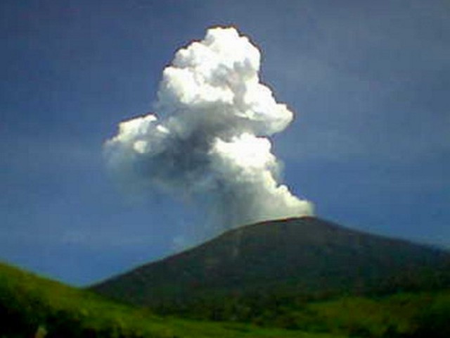 |
Figure 1. Photo of the plume resulting from Dempo's phreatic eruption on 25 September 2006. This is one of a set of multiple photos taken of a rising plume. Photo by Fredy, a local resident. Courtesy of CVGHM. |
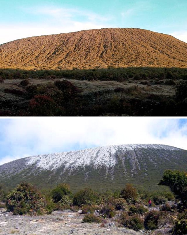 |
Figure 2. (top) Pre-eruption and (bottom) post-eruption scenes from the saddle between the cones of Dempo and Marapi looking upslope towards Marapi (which contains the source vent in a steep-sided crater not visible from this perspective). The shots were taken on 7 and 26 September 2009, respectively. Freshly deposited mud and evidence of ejected crater-lake water in the foreground (bottom) represents distal deposits from the 25 September eruption; note peson at right for scale. Large blocks were not from this eruption. Courtesy of the Dempo inspection team, CVGHM. |
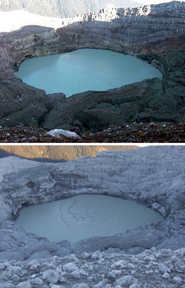 |
Figure 3. Pre- and post-eruption photos looking into Marapi crater at Dempo, taken on 7 (top) and 26 (bottom) September 2006. The lake is on the order of 400 m across. The bottom photo portrays the crater's mud-covered walls and sediment-covered lake. Comparison of both photos indicates that after the eruption the lake surface had dropped, consistent with discharge of water and mud. Camera look-direction unstated. Courtesy of the Dempo inspection team, CVGHM. |
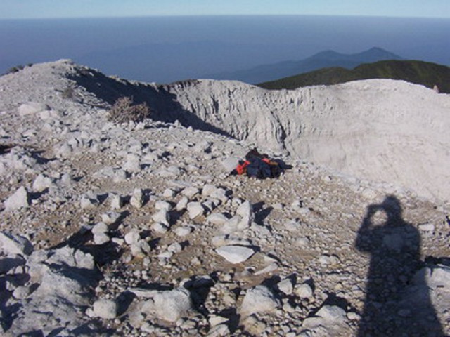 |
Figure 4. Post-eruption conditions on Dempo's Marapi cone seen from a point a few meters back from the crater rim. Widespread gray-to-brown mud covered the rim and upper crater, creating a desolate scene. The large angular blocks on the rim were placed there in previous events, not the 25 September 2009 eruption. Unstated direction; photographers shadow and gear for scale. Courtesy of the Dempo inspection team, CVGHM. |
Information Contacts: Center of Volcanology and Geological Hazard Mitigation (CVGHM), Jalan Diponegoro 57, Bandung 40122, Indonesia (URL: http://vsi.esdm.go.id/).
Phreatic explosion from the crater lake generates a dense ash plume in November 2017
Activity at Dempo on Sumatra in recent years has consisted of brief phreatic eruptions, most recently single-day events on 25 September 2006 (BGVN 34:03) and 1 January 2009 (BGVN 34:01). There were no additional reports from the Center of Volcanology and Geological Hazard Mitigation (CVGHM), also known as Pusat Vulkanologi dan Mitigasi Bencana Geologi (PVMBG), until a brief episode of unrest in late April 2015, Another typically short phreatic explosion took place on 9 November 2017.
Activity during 2015. On 29 April the Alert Level was raised to 2 (on a scale of 1-4) by PVMBG following observations of diffuse white-gray plumes on 27 April rising to 50 m above the crater. Seismicity had increased during April compared to the previous month (figure 5). A Detik news report on 30 April quoted the PVMBG Head of the Western Volcano Field of Observation and Investigation, Hendra Gunawan, as saying that there had been tremor recorded over the previous four days. No ashfall was reported by PVMBG, and a phreatic eruption was only mentioned in the 29 April notice as a potential danger.
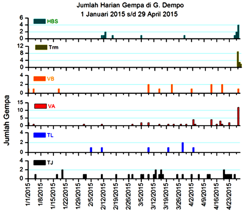 |
Figure 5. Seismicity recorded at Dempo from 1 January to 29 April 2015. The types of earthquakes reported are HBS (Hembusan, puff or emission events), Trm (tremor), VB (shallow volcanic type B), VA (volcanic type A), TL (local tectonic), and TJ (distant tectonic). Courtesy of PVMBG. |
Observers reported that during 1 June-9 September 2015 no plumes were seen and seismicity was low. On 10 September PVMBG lowered the Alert Level to 1.
Activity during 2017. Staff at the PVMBG Dempo observation post reported that no plumes rose from the crater during January and February 2017, but some diffuse white plumes during 1 March-4 April rose no higher than 50 m. Seismicity increased significantly above background levels from 21 March to 4 April (figure 5). On 5 April PVMBG raised the Alert Level to 2 based on visual and seismic data, but did not report any phreatic eruptions.
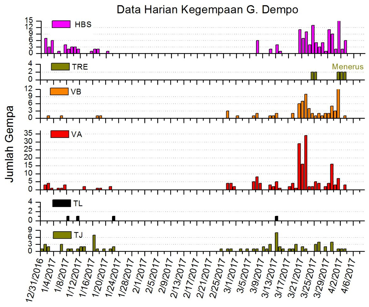 |
Figure 6. Seismicity recorded at Dempo from 31 December 2016 to 6 April 2017. The types of earthquakes reported are HBS (Hembusan, puff or emission events), TRE (tremor), VB (shallow volcanic type B), VA (volcanic type A), TL (local tectonic), and TJ (distant tectonic). Courtesy of PVMBG. |
According to PVMBG a three-minute-long phreatic eruption began at 1651 on 9 November 2017 and generated a dense ash plume that rose to 4.2 km altitude, about 1 km above the crater rim, and drifted S. Ashfall and sulfur gases were reported in villages on the S flanks, but there was no damage to property or injuries. The Alert Level remained at 2, with a 3-km-diameter exclusion zone; the Aviation Color Code was at Yellow.
Information Contacts: Pusat Vulkanologi dan Mitigasi Bencana Geologi (PVMBG, also known as Indonesian Center for Volcanology and Geological Hazard Mitigation, CVGHM), Jalan Diponegoro 57, Bandung 40122, Indonesia (URL: http://www.vsi.esdm.go.id/); Detiknews (URL: https://news.detik.com/).
Phreatic explosion on 31 May 2022
The Dempo stratovolcano in SE Sumatra, Indonesia, has had many small explosive eruptions reported since 1817. The active Marapi crater (750 x 1,100 m) in the summit area contains a 400-m-wide crater lake (figure 7). Recent activity has consisted of single-day phreatic explosions in September 2006, January 2009, and November 2017. Indonesian’s Center of Volcanology and Geological Hazard Mitigation (CVGHM), also known as Pusat Vulkanologi dan Mitigasi Bencana Geologi (PVMBG), is the monitoring agency.
|
Figure 7. Satellite image of Dempo on 30 May 2022, showing the 400-m-wide crater lake within the Marapi summit crater. Sentinel-2 image with natural color rendering (bands 4, 3, 2). Courtesy of Sentinel Hub Playground. |
PVMBG reported phreatic explosion similar to those of recent years at 0154 on 31 May 2022. This event lasted 239 seconds and produced ashfall in areas within 5 km, including Pagar Alam Utara district (E) and North Dempo District; ash deposits were as thick as 1 mm. The Alert Level remained at 2 (on a scale of 1-4), and the public were reminded to stay 1 km away from the crater and as far as 2 km on the N flank.
Information Contacts: Pusat Vulkanologi dan Mitigasi Bencana Geologi (PVMBG, also known as Indonesian Center for Volcanology and Geological Hazard Mitigation, CVGHM), Jalan Diponegoro 57, Bandung 40122, Indonesia (URL: http://www.vsi.esdm.go.id/); Sentinel Hub Playground (URL: https://www.sentinel-hub.com/explore/sentinel-playground).
This compilation of synonyms and subsidiary features may not be comprehensive. Features are organized into four major categories: Cones, Craters, Domes, and Thermal Features. Synonyms of features appear indented below the primary name. In some cases additional feature type, elevation, or location details are provided.
Cones |
||||
| Feature Name | Feature Type | Elevation | Latitude | Longitude |
| Gunung Dempo | Stratovolcano | 3032 m | 4° 1' 18" S | 103° 8' 0" E |
| Marapi, Gunung | Stratovolcano | 3142 m | 4° 0' 56" S | 103° 7' 41" E |
|
|
||||||||||||||||||||||||
There is data available for 30 confirmed Holocene eruptive periods.
2023 Jul 25 - 2023 Aug 21 Confirmed Eruption
| Episode 1 | Eruption Episode | ||||
|---|---|---|---|---|
| 2023 Jul 25 - 2023 Aug 21 | Evidence from Observations: Reported | |||
2022 May 31 - 2022 May 31 Confirmed Eruption Max VEI: 1
| Episode 1 | Phreatic Episode | |||||||||||||||||||||||||
|---|---|---|---|---|---|---|---|---|---|---|---|---|---|---|---|---|---|---|---|---|---|---|---|---|---|
| 2022 May 31 - 2022 May 31 | Evidence from Observations: Reported | ||||||||||||||||||||||||
| Phreatic explosion similar to those of recent years at 0154 on 31 May 2022. This event lasted 239 seconds and produced ashfall in areas within 5 km, including Pagar Alam Utara district (E) and North Dempo District; ash deposits were as thick as 1 mm. | |||||||||||||||||||||||||
|
List of 3 Events for Episode 1
| |||||||||||||||||||||||||
2017 Nov 9 - 2017 Nov 9 Confirmed Eruption Max VEI: 1
| Episode 1 | Eruption Episode | |||||||||||||||
|---|---|---|---|---|---|---|---|---|---|---|---|---|---|---|---|
| 2017 Nov 9 - 2017 Nov 9 | Evidence from Observations: Reported | ||||||||||||||
|
List of 1 Events for Episode 1
| |||||||||||||||
2009 Jan 1 - 2009 Jan 1 Confirmed Eruption Max VEI: 1 (?)
| Episode 1 | Eruption Episode | |||||||||||||||||||||||||
|---|---|---|---|---|---|---|---|---|---|---|---|---|---|---|---|---|---|---|---|---|---|---|---|---|---|
| 2009 Jan 1 - 2009 Jan 1 | Evidence from Observations: Reported | ||||||||||||||||||||||||
|
List of 3 Events for Episode 1
| |||||||||||||||||||||||||
2006 Sep 25 - 2006 Sep 25 Confirmed Eruption Max VEI: 1
| Episode 1 | Eruption Episode | ||||||||||||||||||||
|---|---|---|---|---|---|---|---|---|---|---|---|---|---|---|---|---|---|---|---|---|
| 2006 Sep 25 - 2006 Sep 25 | Evidence from Observations: Reported | |||||||||||||||||||
|
List of 2 Events for Episode 1
| ||||||||||||||||||||
1994 Oct 16 ± 15 days - 1994 Oct 16 ± 15 days Confirmed Eruption Max VEI: 1
| Episode 1 | Eruption Episode | |||||||||||||||||||||||||
|---|---|---|---|---|---|---|---|---|---|---|---|---|---|---|---|---|---|---|---|---|---|---|---|---|---|
| 1994 Oct 16 ± 15 days - 1994 Oct 16 ± 15 days | Evidence from Observations: Reported | ||||||||||||||||||||||||
|
List of 3 Events for Episode 1
| |||||||||||||||||||||||||
1974 Feb 26 - 1974 Oct 20 Confirmed Eruption Max VEI: 2
| Episode 1 | Eruption Episode | ||||||||||||||||||||||||||||||||||||||||
|---|---|---|---|---|---|---|---|---|---|---|---|---|---|---|---|---|---|---|---|---|---|---|---|---|---|---|---|---|---|---|---|---|---|---|---|---|---|---|---|---|
| 1974 Feb 26 - 1974 Oct 20 | Evidence from Observations: Reported | |||||||||||||||||||||||||||||||||||||||
|
List of 6 Events for Episode 1
| ||||||||||||||||||||||||||||||||||||||||
1973 Jan 24 - 1973 Jan 25 Confirmed Eruption Max VEI: 2
| Episode 1 | Eruption Episode | ||||||||||||||||||||||||||||||
|---|---|---|---|---|---|---|---|---|---|---|---|---|---|---|---|---|---|---|---|---|---|---|---|---|---|---|---|---|---|---|
| 1973 Jan 24 - 1973 Jan 25 | Evidence from Observations: Reported | |||||||||||||||||||||||||||||
|
List of 4 Events for Episode 1
| ||||||||||||||||||||||||||||||
1964 Feb 14 - 1964 Feb 14 Confirmed Eruption Max VEI: 2
| Episode 1 | Eruption Episode | |||||||||||||||||||||||||
|---|---|---|---|---|---|---|---|---|---|---|---|---|---|---|---|---|---|---|---|---|---|---|---|---|---|
| 1964 Feb 14 - 1964 Feb 14 | Evidence from Observations: Reported | ||||||||||||||||||||||||
|
List of 3 Events for Episode 1
| |||||||||||||||||||||||||
1940 Jul Confirmed Eruption Max VEI: 2
| Episode 1 | Eruption Episode | ||||||||||||||||||||
|---|---|---|---|---|---|---|---|---|---|---|---|---|---|---|---|---|---|---|---|---|
| 1940 Jul - Unknown | Evidence from Observations: Reported | |||||||||||||||||||
|
List of 2 Events for Episode 1
| ||||||||||||||||||||
1939 Dec 19 - 1940 Feb 21 Confirmed Eruption Max VEI: 2
| Episode 1 | Eruption Episode | |||||||||||||||||||||||||||||||||||||||||||||
|---|---|---|---|---|---|---|---|---|---|---|---|---|---|---|---|---|---|---|---|---|---|---|---|---|---|---|---|---|---|---|---|---|---|---|---|---|---|---|---|---|---|---|---|---|---|
| 1939 Dec 19 - 1940 Feb 21 | Evidence from Observations: Reported | ||||||||||||||||||||||||||||||||||||||||||||
|
List of 7 Events for Episode 1
| |||||||||||||||||||||||||||||||||||||||||||||
1939 Jul 18 - 1939 Jul 30 Confirmed Eruption Max VEI: 2
| Episode 1 | Eruption Episode | |||||||||||||||||||||||||||||||||||
|---|---|---|---|---|---|---|---|---|---|---|---|---|---|---|---|---|---|---|---|---|---|---|---|---|---|---|---|---|---|---|---|---|---|---|---|
| 1939 Jul 18 - 1939 Jul 30 | Evidence from Observations: Reported | ||||||||||||||||||||||||||||||||||
|
List of 5 Events for Episode 1
| |||||||||||||||||||||||||||||||||||
1936 Nov 26 - 1936 Nov 27 Confirmed Eruption Max VEI: 2
| Episode 1 | Eruption Episode | ||||||||||||||||||||||||||||||
|---|---|---|---|---|---|---|---|---|---|---|---|---|---|---|---|---|---|---|---|---|---|---|---|---|---|---|---|---|---|---|
| 1936 Nov 26 - 1936 Nov 27 | Evidence from Observations: Reported | |||||||||||||||||||||||||||||
|
List of 4 Events for Episode 1
| ||||||||||||||||||||||||||||||
1934 Jan 24 - 1934 Apr 25 Confirmed Eruption Max VEI: 2
| Episode 1 | Eruption Episode | ||||||||||||||||||||||||||||||
|---|---|---|---|---|---|---|---|---|---|---|---|---|---|---|---|---|---|---|---|---|---|---|---|---|---|---|---|---|---|---|
| 1934 Jan 24 - 1934 Apr 25 | Evidence from Observations: Reported | |||||||||||||||||||||||||||||
|
List of 4 Events for Episode 1
| ||||||||||||||||||||||||||||||
1926 Apr 22 - 1926 Apr 24 Confirmed Eruption Max VEI: 2
| Episode 1 | Eruption Episode | |||||||||||||||||||||||||
|---|---|---|---|---|---|---|---|---|---|---|---|---|---|---|---|---|---|---|---|---|---|---|---|---|---|
| 1926 Apr 22 - 1926 Apr 24 | Evidence from Observations: Reported | ||||||||||||||||||||||||
|
List of 3 Events for Episode 1
| |||||||||||||||||||||||||
1923 May 19 (?) - 1923 May 19 (?) Confirmed Eruption Max VEI: 1
| Episode 1 | Eruption Episode | ||||||||||||||||||||
|---|---|---|---|---|---|---|---|---|---|---|---|---|---|---|---|---|---|---|---|---|
| 1923 May 19 (?) - 1923 May 19 (?) | Evidence from Observations: Reported | |||||||||||||||||||
|
List of 2 Events for Episode 1
| ||||||||||||||||||||
1921 Apr - 1921 Apr Confirmed Eruption Max VEI: 1
| Episode 1 | Eruption Episode | ||||||||||||||||||||
|---|---|---|---|---|---|---|---|---|---|---|---|---|---|---|---|---|---|---|---|---|
| 1921 Apr - 1921 Apr | Evidence from Observations: Reported | |||||||||||||||||||
|
List of 2 Events for Episode 1
| ||||||||||||||||||||
1908 Feb 16 - 1908 Feb 17 Confirmed Eruption Max VEI: 2
| Episode 1 | Eruption Episode | ||||||||||||||||||||||||||||||
|---|---|---|---|---|---|---|---|---|---|---|---|---|---|---|---|---|---|---|---|---|---|---|---|---|---|---|---|---|---|---|
| 1908 Feb 16 - 1908 Feb 17 | Evidence from Observations: Reported | |||||||||||||||||||||||||||||
|
List of 4 Events for Episode 1
| ||||||||||||||||||||||||||||||
1905 Confirmed Eruption Max VEI: 0
| Episode 1 | Eruption Episode | ||||||||||||||||||||
|---|---|---|---|---|---|---|---|---|---|---|---|---|---|---|---|---|---|---|---|---|
| 1905 - Unknown | Evidence from Observations: Reported | |||||||||||||||||||
|
List of 2 Events for Episode 1
| ||||||||||||||||||||
1900 Oct 26 - 1900 Oct 27 Confirmed Eruption Max VEI: 2
| Episode 1 | Eruption Episode | ||||||||||||||||||||
|---|---|---|---|---|---|---|---|---|---|---|---|---|---|---|---|---|---|---|---|---|
| 1900 Oct 26 - 1900 Oct 27 | Evidence from Observations: Reported | |||||||||||||||||||
|
List of 2 Events for Episode 1
| ||||||||||||||||||||
1900 Jun 4 - 1900 Jun 4 Confirmed Eruption Max VEI: 2
| Episode 1 | Eruption Episode | |||||||||||||||||||||||||
|---|---|---|---|---|---|---|---|---|---|---|---|---|---|---|---|---|---|---|---|---|---|---|---|---|---|
| 1900 Jun 4 - 1900 Jun 4 | Evidence from Observations: Reported | ||||||||||||||||||||||||
|
List of 3 Events for Episode 1
| |||||||||||||||||||||||||
1895 Jul 2 - 1895 Sep 30 Confirmed Eruption Max VEI: 2
| Episode 1 | Eruption Episode | ||||||||||||||||||||||||||||||
|---|---|---|---|---|---|---|---|---|---|---|---|---|---|---|---|---|---|---|---|---|---|---|---|---|---|---|---|---|---|---|
| 1895 Jul 2 - 1895 Sep 30 | Evidence from Observations: Reported | |||||||||||||||||||||||||||||
|
List of 4 Events for Episode 1
| ||||||||||||||||||||||||||||||
1884 Jun - 1884 Jul Confirmed Eruption Max VEI: 2
| Episode 1 | Eruption Episode | ||||||||||||||||||||
|---|---|---|---|---|---|---|---|---|---|---|---|---|---|---|---|---|---|---|---|---|
| 1884 Jun - 1884 Jul | Evidence from Observations: Reported | |||||||||||||||||||
|
List of 2 Events for Episode 1
| ||||||||||||||||||||
1881 Dec - 1881 Dec Confirmed Eruption Max VEI: 2
| Episode 1 | Eruption Episode | ||||||||||||||||||||
|---|---|---|---|---|---|---|---|---|---|---|---|---|---|---|---|---|---|---|---|---|
| 1881 Dec - 1881 Dec | Evidence from Observations: Reported | |||||||||||||||||||
|
List of 2 Events for Episode 1
| ||||||||||||||||||||
1881 Feb 16 Confirmed Eruption Max VEI: 2
| Episode 1 | Eruption Episode | ||||||||||||||||||||||||||||||
|---|---|---|---|---|---|---|---|---|---|---|---|---|---|---|---|---|---|---|---|---|---|---|---|---|---|---|---|---|---|---|
| 1881 Feb 16 - Unknown | Evidence from Observations: Reported | |||||||||||||||||||||||||||||
|
List of 4 Events for Episode 1
| ||||||||||||||||||||||||||||||
1880 May Confirmed Eruption Max VEI: 2
| Episode 1 | Eruption Episode | ||||||||||||||||||||
|---|---|---|---|---|---|---|---|---|---|---|---|---|---|---|---|---|---|---|---|---|
| 1880 May - Unknown | Evidence from Observations: Reported | |||||||||||||||||||
|
List of 2 Events for Episode 1
| ||||||||||||||||||||
1879 May 18 Confirmed Eruption Max VEI: 2
| Episode 1 | Eruption Episode | ||||||||||||||||||||
|---|---|---|---|---|---|---|---|---|---|---|---|---|---|---|---|---|---|---|---|---|
| 1879 May 18 - Unknown | Evidence from Observations: Reported | |||||||||||||||||||
|
List of 2 Events for Episode 1
| ||||||||||||||||||||
1853 Jan 1 Confirmed Eruption Max VEI: 2
| Episode 1 | Eruption Episode | ||||||||||||||||||||
|---|---|---|---|---|---|---|---|---|---|---|---|---|---|---|---|---|---|---|---|---|
| 1853 Jan 1 - Unknown | Evidence from Observations: Reported | |||||||||||||||||||
|
List of 2 Events for Episode 1
| ||||||||||||||||||||
1839 (?) Confirmed Eruption Max VEI: 2
| Episode 1 | Eruption Episode | ||||||||||||||||||||
|---|---|---|---|---|---|---|---|---|---|---|---|---|---|---|---|---|---|---|---|---|
| 1839 (?) - Unknown | Evidence from Observations: Reported | |||||||||||||||||||
|
List of 2 Events for Episode 1
| ||||||||||||||||||||
1817 Dec 31 ± 365 days Confirmed Eruption Max VEI: 2
| Episode 1 | Eruption Episode | ||||||||||||||||||||
|---|---|---|---|---|---|---|---|---|---|---|---|---|---|---|---|---|---|---|---|---|
| 1817 Dec 31 ± 365 days - Unknown | Evidence from Observations: Reported | |||||||||||||||||||
|
List of 2 Events for Episode 1
| ||||||||||||||||||||
There is no Deformation History data available for Dempo.
There is no Emissions History data available for Dempo.
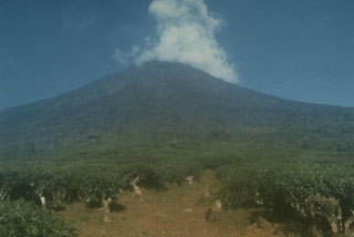 A meteorological cloud rises above the summit of Dempo stratovolcano in SE Sumatra, towering nearly 3 km above tea plantations below its E flank. Dempo has produced frequent historical recent small-to-moderate explosive eruptions. The summit contains seven partially overlapping craters, the youngest of which is partially filled by a crater lake.
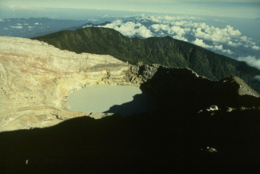
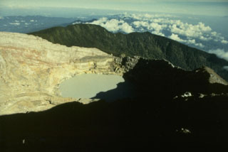 The youngest crater of Dempo volcano, at the WNW end of a series of six partially overlapping craters at the summit, contains a 400-m-wide crater lake that has been the source of frequent phreatic eruptions during historical time. A seventh smaller crater is located on the upper N flank. Dempo is one of Sumatra's most active volcanoes, frequently producing small-to-moderate explosive eruptions.
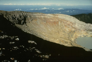 The crater wall of Kawah Merapi, the youngest and NW-most of the craters along the summit of Dempo volcano, is capped by thin lava flows. A crater lake is seen at the lower right in this view from the NE. Gunung Merapi, the high point of the summit region of Dempo volcano, occurs at the extreme left at the SE part of the crater rim.
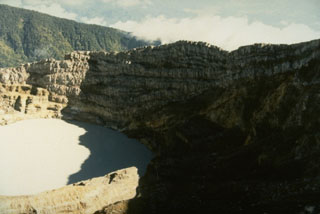 The crater wall above the historically active crater lake within Kawah Merapi crater at the summit of Dempo volcano shows a series of alternating lava flows and pyroclastic deposits.
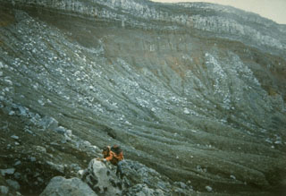 A scientist from the Volcanological Survey of Indonesia investigates rocks in the summit crater of Dempo volcano. The Kawah Merapi crater exposes bedded pyroclastic material that is overlain by a series of light-colored lava flows.
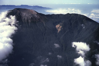 An aerial view from the N shows the summit crater of Dempo volcano to the upper left. The steep-walled crater contains a lake, which has been the source of frequent phreatic eruptions during historical time.
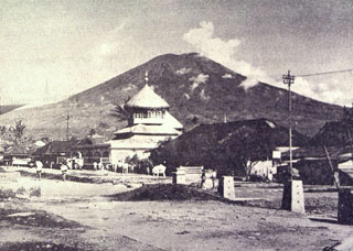 Gunung Dempo, one of the most active volcanoes of Sumatra, has a conical profile when viewed from the village of Pager Alam below the eastern flank of the volcano. The summit contains nested craters on its NW side.
The maps shown below have been scanned from the GVP map archives and include the volcano on this page. Clicking on the small images will load the full 300 dpi map. Very small-scale maps (such as world maps) are not included. The maps database originated over 30 years ago, but was only recently updated and connected to our main database. We welcome users to tell us if they see incorrect information or other problems with the maps; please use the Contact GVP link at the bottom of the page to send us email.
There are no samples for Dempo in the Smithsonian's NMNH Department of Mineral Sciences Rock and Ore collection.
| Copernicus Browser | The Copernicus Browser replaced the Sentinel Hub Playground browser in 2023, to provide access to Earth observation archives from the Copernicus Data Space Ecosystem, the main distribution platform for data from the EU Copernicus missions. |
| MIROVA | Middle InfraRed Observation of Volcanic Activity (MIROVA) is a near real time volcanic hot-spot detection system based on the analysis of MODIS (Moderate Resolution Imaging Spectroradiometer) data. In particular, MIROVA uses the Middle InfraRed Radiation (MIR), measured over target volcanoes, in order to detect, locate and measure the heat radiation sourced from volcanic activity. |
| MODVOLC Thermal Alerts | Using infrared satellite Moderate Resolution Imaging Spectroradiometer (MODIS) data, scientists at the Hawai'i Institute of Geophysics and Planetology, University of Hawai'i, developed an automated system called MODVOLC to map thermal hot-spots in near real time. For each MODIS image, the algorithm automatically scans each 1 km pixel within it to check for high-temperature hot-spots. When one is found the date, time, location, and intensity are recorded. MODIS looks at every square km of the Earth every 48 hours, once during the day and once during the night, and the presence of two MODIS sensors in space allows at least four hot-spot observations every two days. Each day updated global maps are compiled to display the locations of all hot spots detected in the previous 24 hours. There is a drop-down list with volcano names which allow users to 'zoom-in' and examine the distribution of hot-spots at a variety of spatial scales. |
|
WOVOdat
Single Volcano View Temporal Evolution of Unrest Side by Side Volcanoes |
WOVOdat is a database of volcanic unrest; instrumentally and visually recorded changes in seismicity, ground deformation, gas emission, and other parameters from their normal baselines. It is sponsored by the World Organization of Volcano Observatories (WOVO) and presently hosted at the Earth Observatory of Singapore.
GVMID Data on Volcano Monitoring Infrastructure The Global Volcano Monitoring Infrastructure Database GVMID, is aimed at documenting and improving capabilities of volcano monitoring from the ground and space. GVMID should provide a snapshot and baseline view of the techniques and instrumentation that are in place at various volcanoes, which can be use by volcano observatories as reference to setup new monitoring system or improving networks at a specific volcano. These data will allow identification of what monitoring gaps exist, which can be then targeted by remote sensing infrastructure and future instrument deployments. |
| Volcanic Hazard Maps | The IAVCEI Commission on Volcanic Hazards and Risk has a Volcanic Hazard Maps database designed to serve as a resource for hazard mappers (or other interested parties) to explore how common issues in hazard map development have been addressed at different volcanoes, in different countries, for different hazards, and for different intended audiences. In addition to the comprehensive, searchable Volcanic Hazard Maps Database, this website contains information about diversity of volcanic hazard maps, illustrated using examples from the database. This site is for educational purposes related to volcanic hazard maps. Hazard maps found on this website should not be used for emergency purposes. For the most recent, official hazard map for a particular volcano, please seek out the proper institutional authorities on the matter. |
| IRIS seismic stations/networks | Incorporated Research Institutions for Seismology (IRIS) Data Services map showing the location of seismic stations from all available networks (permanent or temporary) within a radius of 0.18° (about 20 km at mid-latitudes) from the given location of Dempo. Users can customize a variety of filters and options in the left panel. Note that if there are no stations are known the map will default to show the entire world with a "No data matched request" error notice. |
| UNAVCO GPS/GNSS stations | Geodetic Data Services map from UNAVCO showing the location of GPS/GNSS stations from all available networks (permanent or temporary) within a radius of 20 km from the given location of Dempo. Users can customize the data search based on station or network names, location, and time window. Requires Adobe Flash Player. |
| DECADE Data | The DECADE portal, still in the developmental stage, serves as an example of the proposed interoperability between The Smithsonian Institution's Global Volcanism Program, the Mapping Gas Emissions (MaGa) Database, and the EarthChem Geochemical Portal. The Deep Earth Carbon Degassing (DECADE) initiative seeks to use new and established technologies to determine accurate global fluxes of volcanic CO2 to the atmosphere, but installing CO2 monitoring networks on 20 of the world's 150 most actively degassing volcanoes. The group uses related laboratory-based studies (direct gas sampling and analysis, melt inclusions) to provide new data for direct degassing of deep earth carbon to the atmosphere. |
| Large Eruptions of Dempo | Information about large Quaternary eruptions (VEI >= 4) is cataloged in the Large Magnitude Explosive Volcanic Eruptions (LaMEVE) database of the Volcano Global Risk Identification and Analysis Project (VOGRIPA). |
| EarthChem | EarthChem develops and maintains databases, software, and services that support the preservation, discovery, access and analysis of geochemical data, and facilitate their integration with the broad array of other available earth science parameters. EarthChem is operated by a joint team of disciplinary scientists, data scientists, data managers and information technology developers who are part of the NSF-funded data facility Integrated Earth Data Applications (IEDA). IEDA is a collaborative effort of EarthChem and the Marine Geoscience Data System (MGDS). |

