PVMBG lowered the Alert Level for Karangetang to 2 (on a scale of 1-4) on 29 November due to declining activity. According to a news article seismic data and visual observations indicated that effusion had decreased or ceased and that lava avalanches were no longer observed. Seismicity decreased and deformation data indicated deflation. The public was warned to stay 1.5 km away from both Main Crater and North Crater with an extension to 2.5 km on the S and SE flanks.
Sources: Pusat Vulkanologi dan Mitigasi Bencana Geologi (PVMBG, also known as CVGHM), Antara News
Weak thermal activity and gas-and-steam emissions during July-December 2022
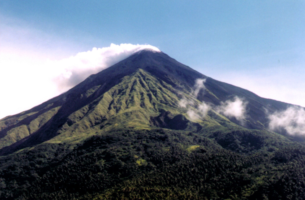
Karangetang (also known as Api Siau), at the northern end of the island of Siau, Indonesia, contains five summit craters along a N-S line. More than 40 eruptions have been recorded since 1675; twentieth-century eruptions have included frequent explosive activity, sometimes accompanied by pyroclastic flows and lahars. Lava dome growth has occurred in the summit craters and collapses of lava flow fronts have produced pyroclastic flows. The two active summit craters are Kawah Dua (the N crater) and Kawah Utama (the S crater, also referred to as the “Main Crater”). The most recent eruption began in late November 2018 and has more recently consisted of intermittent white-and-gray gas-and-steam plumes and summit crater incandescence (BGVN 47:07). This report covers activity during July through December 2022, characterized by crater incandescence and near daily white gas-and-steam emissions, based on reports from Pusat Vulkanologi dan Mitigasi Bencana Geologi (PVMBG, also known as CVGHM, or the Center of Volcanology and Geological Hazard Mitigation), MAGMA Indonesia, and satellite data.
Relatively low activity during the reporting period was mainly characterized by almost daily white, and less frequently gray, gas-and-steam emissions that rose 25-200 m above the summit (figure 57). Incandescence from the S crater on 9 November and from both the N and S craters on 14 November was visible in satellite images. MIROVA (Middle InfraRed Observation of Volcanic Activity) analysis of MODIS satellite data showed weak-to-moderate power thermal anomalies during August through mid-December 2022 (figure 58). There was only one small anomaly detected during early July. By later August, thermal activity began to increase in both frequency and power, which peaked during late September and then began to decline. Anomalies were then lower in power and less frequent during October through mid-December. A thermal anomaly was visible in Sentinel-2 infrared satellite imagery in the N summit crater throughout the reporting period, occasionally accompanied by gas-and-steam emissions (figure 59). A weaker anomaly was visible in the S summit crater at least on 17 July, 31 August, 15 September, 15 October, and 4 December.
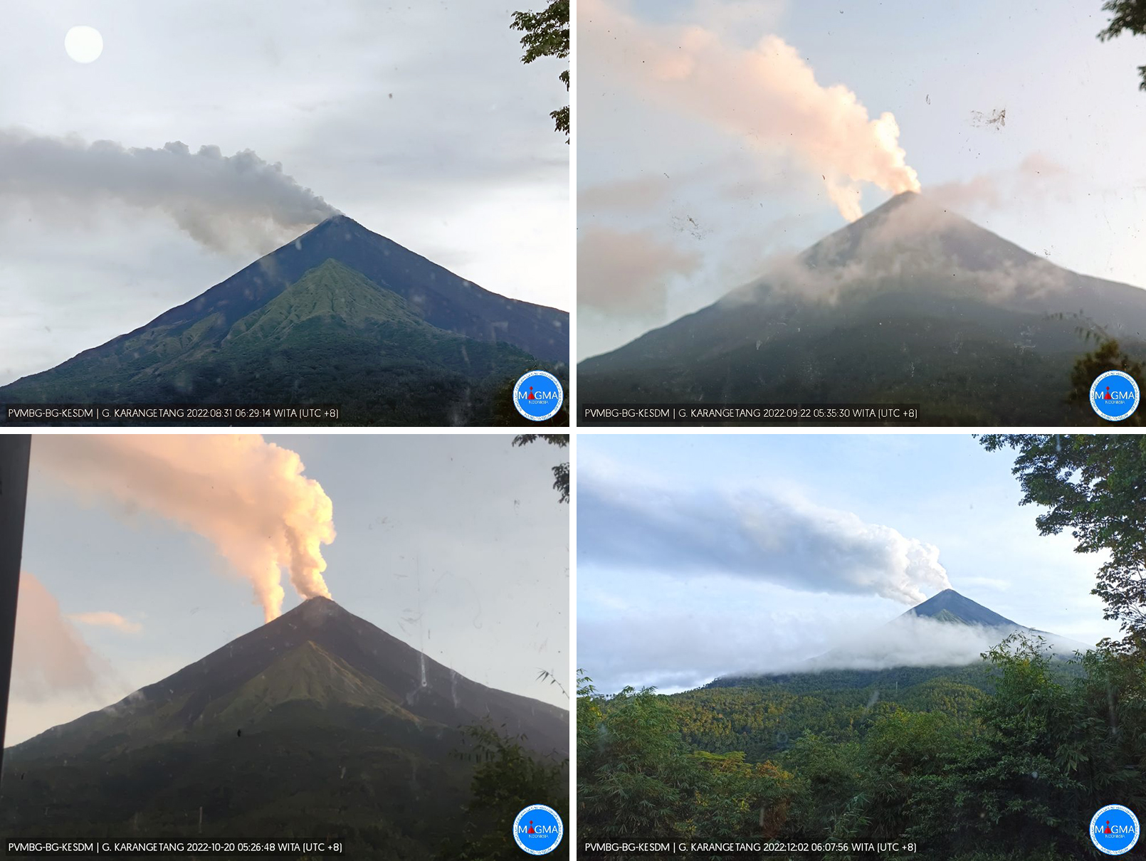 |
Figure 57. Webcam images of Karangetang showing white-to-gray plumes rising above both summit craters on 31 August 2022 (top left), 22 September 2022 (top right), 20 October 2022 (bottom left), and 2 December 2022 (bottom right). Courtesy of MAGMA Indonesia. |
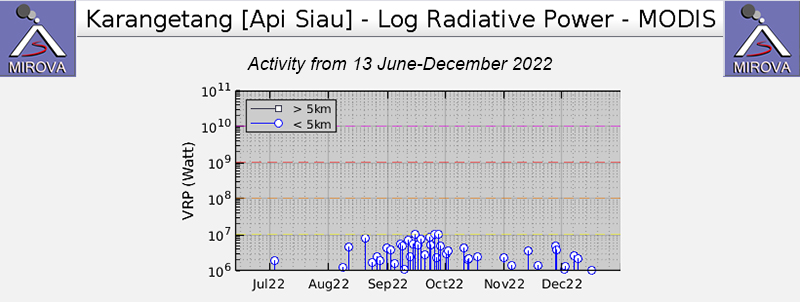 |
Figure 58. Weak-to-moderate power thermal anomalies were detected in the summit area of Karangetang during August through mid-December 2022 as recorded by this MIROVA graph (Log Radiative Power). Only a single low-power anomaly was detected during early July. There was a gradual increase in both power and frequency of anomalies during September, which then had declined by the end of the month. Courtesy of MIROVA. |
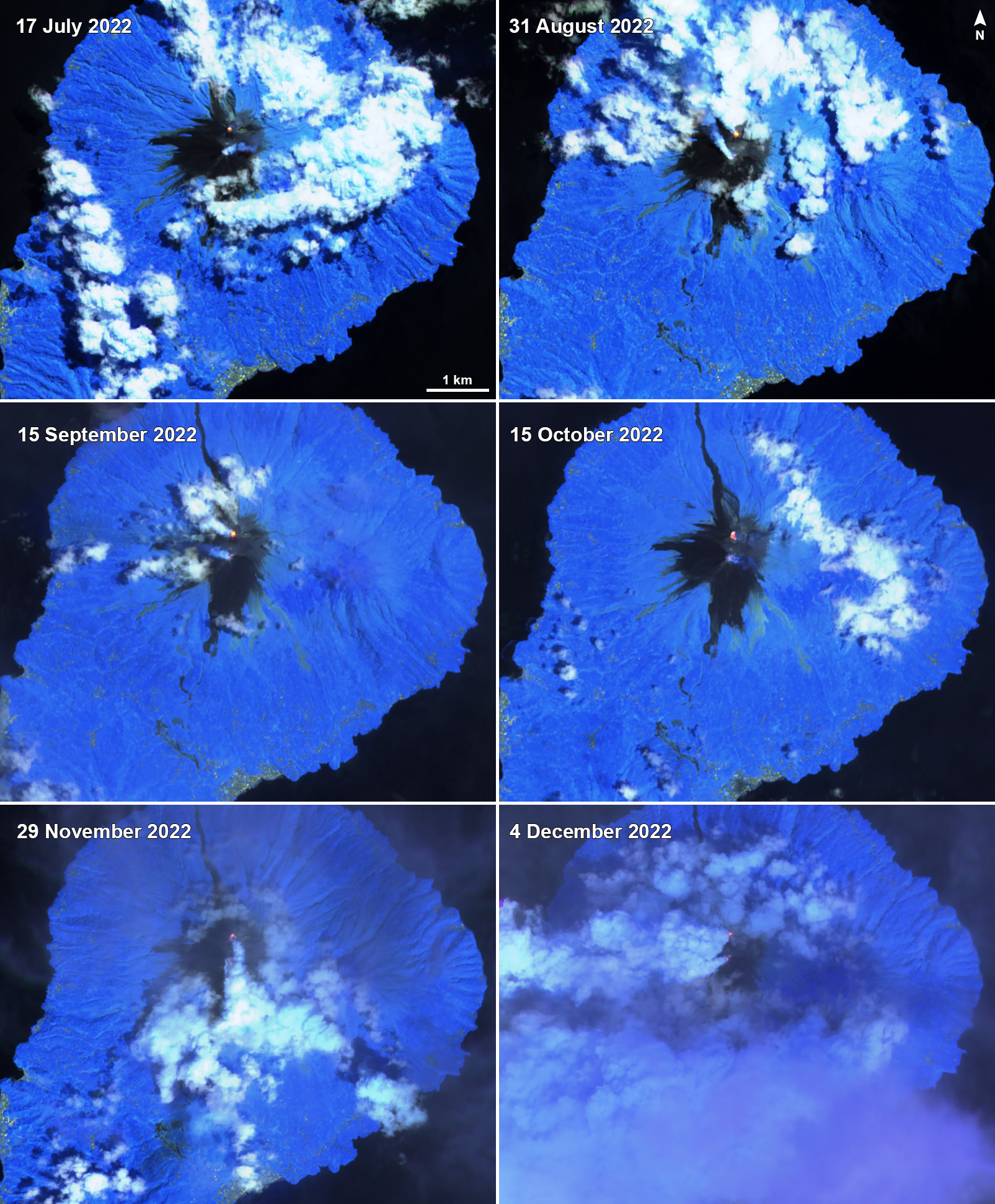 |
Figure 59. A small thermal anomaly (yellow-orange) was visible at the N summit crater at Karangetang on 17 July 2022 (top left), 31 August 2022 (top right), 15 September 2022 (middle left), 15 October 2022 (middle right), 29 November 2022 (bottom left), and 4 December 2022 (bottom right). A weaker anomaly was also detected in the S summit crater during these dates, except on 29 November due to cloud cover. Gas-and-steam emissions were occasionally observed from both summit craters. Images using “Atmospheric penetration” rendering (bands 12, 11, 8a). Courtesy of Sentinel Hub Playground. |
Information Contacts: Pusat Vulkanologi dan Mitigasi Bencana Geologi (PVMBG, also known as Indonesian Center for Volcanology and Geological Hazard Mitigation, CVGHM), Jalan Diponegoro 57, Bandung 40122, Indonesia (URL: http://www.vsi.esdm.go.id/); MAGMA Indonesia, Kementerian Energi dan Sumber Daya Mineral (URL: https://magma.esdm.go.id/v1); MIROVA (Middle InfraRed Observation of Volcanic Activity), a collaborative project between the Universities of Turin and Florence (Italy) supported by the Centre for Volcanic Risk of the Italian Civil Protection Department (URL: http://www.mirovaweb.it/); Sentinel Hub Playground (URL: https://www.sentinel-hub.com/explore/sentinel-playground).
2023: February
| March
| April
| May
| June
| July
| August
| September
| December
2022: January
| November
2021: January
| October
| December
2020: January
| February
| March
| April
2019: January
| February
| March
| April
| July
| August
| September
| October
| November
| December
2018: January
| July
| November
2017: May
2016: January
| February
| March
2015: January
| April
| May
| June
| July
| August
| September
| October
| November
| December
2014: February
| September
| October
2013: April
| July
| August
2012: May
| December
2011: March
| June
| August
2010: February
| August
| September
| December
2009: May
| June
| October
| November
2008: March
| October
| November
2007: February
| March
| April
| June
| August
| October
2006: June
| July
| August
| November
2005: February
| May
| July
| August
| October
2003: January
| February
| March
| April
| May
| July
| October
2002: January
| February
| March
| May
| June
| July
| October
| November
2001: January
| February
| April
| May
| July
| August
| September
| October
| November
2000: November
| December
PVMBG lowered the Alert Level for Karangetang to 2 (on a scale of 1-4) on 29 November due to declining activity. According to a news article seismic data and visual observations indicated that effusion had decreased or ceased and that lava avalanches were no longer observed. Seismicity decreased and deformation data indicated deflation. The public was warned to stay 1.5 km away from both Main Crater and North Crater with an extension to 2.5 km on the S and SE flanks.
Sources: Pusat Vulkanologi dan Mitigasi Bencana Geologi (PVMBG, also known as CVGHM); Antara News
PVMBG reported that dense white gas-and-steam plumes from Karangetang were visible on most days during 13-19 September rising as high as 300 m above Main and North craters and drifting mainly NW, N, and NE. Weather clouds sometimes prevented views of the summit. According to news articles, seismicity during 1-7 September indicated lava from the SW side of Main Crater (S crater) continued to effuse but at a decreased rate, and that the number of earthquakes indicating avalanches had also decreased, according to PVMBG. Lava avalanches traveled as far as 1.5 km down the Batuawang and Kahetang drainages on the S flank and rarely descended the SW flank. Lava effusion at Main Crater was not visible during 8-15 September, though sounds of avalanches were sometimes intense, and rumbling was also occasionally heard. Incandescence emanated from both Main and North craters. The number of avalanches continued to decrease. The Alert Level remained at 3 (on a scale of 1-4) and the public were advised to stay 2.5 km away from Main Crater with an extension to 3.5 km on the S and SE flanks.
Sources: Pusat Vulkanologi dan Mitigasi Bencana Geologi (PVMBG, also known as CVGHM); Antara News; Antara News; Antara News; Antara News; Antara News
PVMBG reported that dense white gas-and-steam plumes from Karangetang were visible daily rising as high as 200 m and drifting multiple directions during 30 August-5 September. Weather clouds sometimes prevented views of the summit. According to news articles, incandescent lava avalanches from Main Crater (S crater) traveled as far as 1.5 km down the Batuawang and Kahetang drainages and as far as 1 km down the Batang, Timbelang, and West Beha drainages. Incandescence at the S and N craters continued to be visible. The Alert Level remained at 3 (on a scale of 1-4) and the public were advised to stay 2.5 km away from Main Crater with an extension to 3.5 km on the S and SE flanks.
Sources: Pusat Vulkanologi dan Mitigasi Bencana Geologi (PVMBG, also known as CVGHM); Antara News; Antara News; Antara News; Antara News
According to 17 and 18 August news articles a total of 39 families (104 people) were able to return to Tatahadeng and Tarorane villages because activity at Karangetang had declined. Incandescent avalanches continued to descend the SW, S, and SE flanks, though the number of events and the distanced traveled were lower. PVMBG reported that dense white gas-and-steam plumes were visible on most days rising as high as 150 m and drifting NE, N, and NW during 23-29 August. Weather clouds sometimes prevented views of the summit. Webcam images published in the reports showed incandescence at the summit and from material on the flanks of Main Crater (S crater). According to a news source, incandescent lava avalanches traveled as far as 1.5 km down the Batuawang drainage and 1.8 km down the Kahetang and Keting drainages. Incandescent material was sometimes ejected up to 25 m above the summit. The Alert Level remained at 3 (on a scale of 1-4) and the public were advised to stay 2.5 km away from Main Crater with an extension to 3.5 km on the S and SE flanks.
Sources: Pusat Vulkanologi dan Mitigasi Bencana Geologi (PVMBG, also known as CVGHM); Antara News; Antara News
PVMBG reported that dense white gas-and-steam plumes from Karangetang were visible daily rising as high as 200 m and drifting multiple directions during 16-22 August. Weather clouds sometimes prevented views of the summit. A webcam images published in the reports showed incandescence at the summit and from material on the flanks of Main Crater (S crater) on 17 August. Pyroclastic flows continued to be generated by collapsing material according to a 17 August new article. The Alert Level remained at 3 (on a scale of 1-4) and the public were advised to stay 2.5 km away from Main Crater with an extension to 3.5 km on the S and SE flanks.
Sources: Pusat Vulkanologi dan Mitigasi Bencana Geologi (PVMBG, also known as CVGHM); Antara News
PVMBG reported that dense white gas-and-steam plumes from Karangetang were visible rising as high as 250 m and drifting multiple directions on most days during 2-8 August. Webcam images published in the reports showed incandescence at the summit and from material on the flanks of Main Crater (S crater). According to a news source, lava avalanches traveled more than 1-1.5 km SW down the Batang, Timbelang, and West Beha drainages. Lava flows in drainages on the S and SW flanks were active; the flow in the Batuawang was 1.5 km long, the flow in Kahetang was more than 1.8 km long, and the flow in Keting was 2.1 km long. Gray clouds sometimes accompanied lava flow activity. Incandescent material was sometimes ejected up to 25 m above the summit. During the end of the week 104 people were evacuated from the Tatahadeng and Tarorane villages, located within a 2.5-km radius of the crater, to evacuation centers and remained there at least through 9 August. Incandescence at the dome in the N crater continued to be visible. The Alert Level remained at 3 (on a scale of 1-4) and the public were advised to stay 2.5 km away from Main Crater with an extension to 3.5 km on the S and SE flanks.
Sources: Pusat Vulkanologi dan Mitigasi Bencana Geologi (PVMBG, also known as CVGHM); Antara News; Antara News; Antara News
PVMBG reported that dense white gas-and-steam plumes from Karangetang were visible rising as high as 100 m and drifting E, NE, NW, and W on most days during 19-25 July. The Darwin VAAC noted that ash plumes rose as high as 2.4 km (8,000 ft) a.s.l. at 1710 on 21 July, at 1530 on 22 July, and at 0850 on 23 July, that drifted NE and E. According to a news source, lava avalanches traveled more than 1.7 km down the Kahetang drainage, 1 km down the Batuawang and Batang drainages, 800 m down the Timbelang drainage, and about 1.5 km down the West Beha drainage during 21-22 July. Dense gray-to-white plumes sometimes accompanied the lava avalanches. The Alert Level remained at 3 (on a scale of 1-4) and the public were advised to stay 2.5 km away from Main Crater with an extension to 3.5 km on the S and SE flanks.
Sources: Pusat Vulkanologi dan Mitigasi Bencana Geologi (PVMBG, also known as CVGHM); Darwin Volcanic Ash Advisory Centre (VAAC); Antara News; Antara News
PVMBG reported that daily dense white gas-and-steam plumes from Karangetang were visible rising as high as 150 m and drifting multiple directions during 12-19 July. Webcam images published in the reports showed incandescence at the summit and from material on the flanks of Main Crater (S crater). On 12 and 17 July PVMBG reported that seismic signals indicating avalanches were frequent. The Alert Level remained at 3 (on a scale of 1-4) and the public were advised to stay 2.5 km away from Main Crater with an extension to 3.5 km on the S and SE flanks.
Source: Pusat Vulkanologi dan Mitigasi Bencana Geologi (PVMBG, also known as CVGHM)
PVMBG reported that daily dense white gas-and-steam plumes from Karangetang were visible rising as high as 300 m and drifting multiple directions during 5-11 July. Periodic webcam images published in the reports showed incandescence at Main Crater (S crater) and from material on the flanks of Main Crater. PVMBG issued Volcano Observatory Notices for Aviation (VONAs) about eruptive events at 0759 and 0850 on 10 July; images showed what appeared to be pyroclastic flows descending the S flank of Main Crater. The Alert Level remained at 3 (on a scale of 1-4) and the public were advised to stay 2.5 km away from Main Crater with an extension to 3.5 km on the S and SE flanks.
Source: Pusat Vulkanologi dan Mitigasi Bencana Geologi (PVMBG, also known as CVGHM)
PVMBG reported that daily dense white gas-and-steam plumes from Karangetang were visible rising as high as 400 m and drifting NE, NW, and W during 28 June-4 July. Periodic webcam images published in the reports showed incandescence at Main Crater (S crater) and from material on the flanks of Main Crater; an image from 1732 on 1 July suggested that a pyroclastic flow descended the SE flank as evident from a linear plume of ash-and-gas rising along its path. Incandescent material extended about 1 km down the S flank and about 600 m down the SSW and SW flanks in a Sentinel satellite image from 2 July. The Alert Level remained at 3 (on a scale of 1-4) and the public were advised to stay 2.5 km away from Main Crater with an extension to 3.5 km on the S and SE flanks.
Sources: Pusat Vulkanologi dan Mitigasi Bencana Geologi (PVMBG, also known as CVGHM); Sentinel Hub
PVMBG reported that dense white gas-and-steam plumes from Karangetang were visible rising as high as 150 m and drifting in multiple directions during 21-27 June. Webcam images published in the reports on 21, 25, and 27 June showed incandescence at Main Crater (S crater) and from material on the flanks of Main Crater. The Alert Level remained at 3 (on a scale of 1-4) and the public were advised to stay 2.5 km away from Main Crater with an extension to 3.5 km on the S and SE flanks.
Source: Pusat Vulkanologi dan Mitigasi Bencana Geologi (PVMBG, also known as CVGHM)
PVMBG reported that dense white gas-and-steam plumes from Karangetang were visible rising as high as 75 m and drifting in multiple directions during 14-20 June. Weather clouds obscured views at times on 14, 16, and 18 June. Webcam images published in the reports showed incandescence at Main Crater (S crater) and from material on the flanks of Main Crater at 0007 on 17 June and 0440 on 18 June. The Alert Level remained at 3 (on a scale of 1-4) and the public were advised to stay 2.5 km away from Main Crater with an extension to 3.5 km on the S and SE flanks.
Source: Pusat Vulkanologi dan Mitigasi Bencana Geologi (PVMBG, also known as CVGHM)
PVMBG reported that daily white gas-and-steam plumes from Karangetang were visible rising as high as 200 m and drifting W, NW, and NE during 7-13 June. Webcam images published in the daily reports showed incandescence at Main Crater (S crater) and from material on the flanks of Main Crater at 2225 on 7 June and 2051 on 9 June. The Alert Level remained at 3 (on a scale of 1-4) and the public were advised to stay 2.5 km away from Main Crater with an extension to 3.5 km on the S and SE flanks.
Source: Pusat Vulkanologi dan Mitigasi Bencana Geologi (PVMBG, also known as CVGHM)
Webcam images of Karangetang published in PVMBG daily reports periodically showed incandescence at Main Crater (S crater) and from material on the flanks of Main Crater during 31 May-6 June. Daily white gas-and-steam plumes were visible rising as high as 150 m above the summit and drifting in various directions. According to the Darwin VAAC ash plumes rose as high as 2.1 km (7,000 ft) a.s.l. and drifted SE and E during 2-4 June. The Alert Level remained at 3 (on a scale of 1-4) and the public were advised to stay 2.5 km away from Main Crater with an extension to 3.5 km on the S and SE flanks.
Sources: Pusat Vulkanologi dan Mitigasi Bencana Geologi (PVMBG, also known as CVGHM); Darwin Volcanic Ash Advisory Centre (VAAC)
Webcam images of Karangetang published in PVMBG daily reports periodically showed incandescence at Main Crater (S crater) and from material on the flanks of Main Crater during 23-30 May. Incandescence at the summit was most intense in the webcam images from 2332 on 26 May and 2304 on 29 May; the material on the flanks was brightest in the 29 May image. White gas-and-steam plumes were visible on most days rising as high as 150 m above the summit and rifting in various directions. The Alert Level remained at 3 (on a scale of 1-4) and the public were advised to stay 2.5 km away from Main Crater with an extension to 3.5 km on the S and SE flanks. The Alert Level remained at 3 (on a scale of 1-4) and the public was warned to stay 2.5 km away from the craters on the S and SW flanks and 1.5 km away on the other flanks.
Source: Pusat Vulkanologi dan Mitigasi Bencana Geologi (PVMBG, also known as CVGHM)
PVMBG reported that activity at Karangetang had intensified in May, leading to a change in the Alert Level status. During 1-17 May white gas-and-steam plumes were sometimes dense and rose as high as 250 m above the summit, slightly higher than the 200 m maximum height noted in April. Incandescence at North Crater was visible at night 10-25 m above the lava dome. Incandescence also emanated from Main Crater though the glow was less intense, reaching about 10 m above the dome. Sounds of falling rocks at Main Crater were heard on 15 May, the seismic network recorded 32 rockfall events in the crater on 17 May, and rock avalanches on 18 May traveled as far as 1.5 km down the SW and S flanks accompanied by rumbling sounds. On 19 May the Alert Level was raised to 3 (on a scale of 1-4) and the public was warned to stay 2.5 km away from the craters on the S and SW flanks and 1.5 km away on the other flanks. A webcam image from 2025 on 19 May showed incandescent material traveling down the flanks. On 21 May white gas-and-steam plumes rose 400 m above the summit.
Source: Pusat Vulkanologi dan Mitigasi Bencana Geologi (PVMBG, also known as CVGHM)
PVMBG reported that the effusive eruption which began around 1700 on 8 February at Karangetang’s Main Crater (S crater) produced lava flows and lava avalanches that traveled as far as 2 km down the SW and S flanks in drainages leading to the Beha, Batang, Timbelang, Batuawang, and Kahetang rivers. Effusion ended on 1 April and avalanches of material were no longer detected. Seismic signals indicating effusion decreased and by 6 April were no longer being detected. Incandescence at both Main Crater and Crater II (N crater) was visible at night during 1-25 April. White gas plumes were seen rising as high as 200 m above the summit and drifted in multiple directions; weather clouds sometimes prevented views. On 26 April the Alert Level was lowered to 2 (on a scale of 1-4) and the public was warned to stay 2.5 km away from the craters on the S and SW flanks and 1.5 km away on the other flanks.
Source: Pusat Vulkanologi dan Mitigasi Bencana Geologi (PVMBG, also known as CVGHM)
Webcam images of Karangetang captured in the PVMBG daily reports periodically showed small areas of incandescence at the summit craters during 11-17 April. The Alert Level remained at 3 (on a scale of 1-4) and the public were advised to stay 2.5 km away from Main Crater with an extension to 3.5 km on the S and SE flanks.
Source: Pusat Vulkanologi dan Mitigasi Bencana Geologi (PVMBG, also known as CVGHM)
Webcam images of Karangetang captured in the PVMBG daily reports periodically showed small areas of incandescence at the summit Main Crater (S crater) and on the flanks during 4-10 April. The Alert Level remained at 3 (on a scale of 1-4) and the public were advised to stay 2.5 km away from Main Crater with an extension to 3.5 km on the S and SE flanks.
Source: Pusat Vulkanologi dan Mitigasi Bencana Geologi (PVMBG, also known as CVGHM)
During 29 March-4 April a webcam image of Karangetang captured in the PVMBG daily reports showed incandescent material at the summit Main Crater (S crater) and on the flanks at 0016 on 1 April. The Alert Level remained at 3 (on a scale of 1-4) and the public were advised to stay 2.5 km away from Main Crater with an extension to 3.5 km on the S and SE flanks.
Source: Pusat Vulkanologi dan Mitigasi Bencana Geologi (PVMBG, also known as CVGHM)
Webcam images of Karangetang posted in PVMBG daily reports during 23-28 March showed incandescent material at the summit Main Crater (S crater) and on the flanks. The Alert Level remained at 3 (on a scale of 1-4) and the public were advised to stay 2.5 km away from Main Crater with an extension to 3.5 km on the S and SE flanks.
Source: Pusat Vulkanologi dan Mitigasi Bencana Geologi (PVMBG, also known as CVGHM)
PVMBG reported that the summit Main Crater (S crater) on Karangetang continued to erupt during 15-21 March. Incandescent material at the summit and on the flanks was evident in webcam images captured at 0007 and 2345 on 16 March,1828 on 17 March, 1940 on 18 March, 2311 on 19 March, and 2351 on 20 March. The incandescence was most intense on 18 and 20 March, with webcam images possibly capturing Strombolian explosions. Based on satellite images, the Darwin VAAC reported that on 18 March an ash plume rose to 2.4 km (6,000 ft) a.s.l. and drifted SW and a thermal anomaly was visible. The Alert Level remained at 3 (the third highest on a scale on a four-level scale) and the Aviation Color Code remained at Orange (the second highest level on a four-color scale).
Sources: Pusat Vulkanologi dan Mitigasi Bencana Geologi (PVMBG, also known as CVGHM); Darwin Volcanic Ash Advisory Centre (VAAC)
Webcam images of Karangetang posted in PVMBG daily reports showed very minor incandescence at the summit Main Crater (S crater) during 8-14 March. Short, dimly incandescent trails on images from 8 and 10 March were possibly from avalanches. According to the Darwin VAAC at 1710 on 9 March an ash plume rose to 2.4 km (8,000 ft) a.s.l. and drifted S. A large thermal anomaly was visible in images from 0550 and 0930 on 10 March. The Alert Level remained at 3 (on a scale of 1-4) and the public were advised to stay 2.5 km away from Main Crater with an extension to 3.5 km on the S and SE flanks.
Sources: Pusat Vulkanologi dan Mitigasi Bencana Geologi (PVMBG, also known as CVGHM); Darwin Volcanic Ash Advisory Centre (VAAC)
According to PVMBG the eruption at Karangetang’s Main Crater (S crater) continued during 1-7 March. Nighttime webcam images posted with daily reports showed flows of incandescent material descending the flanks, though incandescence decreased towards the end of the week. The Alert Level remained at 3 (on a scale of 1-4) and the public were advised to stay 2.5 km away from Main Crater with an extension to 3.5 km on the S and SE flanks.
Source: Pusat Vulkanologi dan Mitigasi Bencana Geologi (PVMBG, also known as CVGHM)
According to PVMBG the eruption at Karangetang’s Main Crater (S crater) continued during 22-28 February. Nighttime webcam images posted with daily reports showed incandescent lava flows descending the flanks, though images from 0054 on 26 February and 0026 on 1 March showed only minor incandescence near the summit. The Darwin VAAC reported that during 22-23 February ash plume rose to an altitude of 2.1 km (7,000 ft) a.s.l. and drifted SE based on analyses of satellite imagery and weather models. The Alert Level remained at 3 (on a scale of 1-4) and the public were advised to stay 2.5 km away from Main Crater with an extension to 3.5 km on the S and SE flanks.
Sources: Pusat Vulkanologi dan Mitigasi Bencana Geologi (PVMBG, also known as CVGHM); Darwin Volcanic Ash Advisory Centre (VAAC)
According to PVMBG the eruption at Karangetang’s Main Crater (S crater) continued during 14-21 February. Multiple nighttime webcam images posted with daily reports showed three main incandescent lava flows of different lengths descending the S, SW, and W flanks; a webcam image from 2156 on 17 February possibly showed incandescent material descending the SE flank. Incandescent rocks dotted the upper flanks, possibly from ejected or collapsed material from the crater; the incandescence was often most intense at the summit. Based on analyses of satellite imagery and weather models, the Darwin VAAC reported that during 16-20 February daily ash plume rose to an altitude of 2.1-3 km (7,000-10,000 ft) a.s.l. and drifted NNE, E, and SE. BNPB reported that as of 16 February there were as many as 77 people that had been displaced by the eruption and were in the East Siau Museum which was designated as a temporary evacuation shelter. The Alert Level remained at 3 (on a scale of 1-4) and the public were advised to stay 2.5 km away from Main Crater with an extension to 3.5 km on the S and SE flanks.
Sources: Pusat Vulkanologi dan Mitigasi Bencana Geologi (PVMBG, also known as CVGHM); Badan Nacional Penanggulangan Bencana (BNPB); Darwin Volcanic Ash Advisory Centre (VAAC)
According to PVMBG the eruption at Karangetang’s Main Crater (S crater) continued during 8-14 February. Multiple nighttime webcam images posted with daily reports showed three main incandescent lava flows of different lengths descending the S, SW, and W flanks. Incandescent rocks dotted the upper flanks, possibly from ejected or collapsed material from the crater; the incandescence was most intense at the summit. The Alert Level remained at 3 (on a scale of 1-4) and the public were advised to stay 2.5 km away from Main Crater with an extension to 3.5 km on the S and SE flanks.
Source: Pusat Vulkanologi dan Mitigasi Bencana Geologi (PVMBG, also known as CVGHM)
PVMBG reported a recent increase in activity at Karangetang. During 1-31 January white-and-gray plumes were occasionally seen rising as high as 150 m from Main Crater (the south crater) and incandescence emanated from the lava dome in Crater II (also called North Crater); weather conditions often prevented visual observations. The number of seismic signals indicating avalanches of material began increasing on 18 January, and then increased again in early February. The number of avalanches from Main Crater increased on 4 February, with material traveling as far as 800 m down the Batuawang (S) and Batang (W) drainages and as far as 1 km W down the Beha (W) drainage. During 1-7 February white plumes rose 50-100 m above both craters.
An eruption began during the evening on 8 February at around 1700. PVMBG raised the Alert Level to 3 (on a scale of 1-4) and advised the public to generally stay 2.5 km away from Main Crater with an extension to 3.5 km on the S and SE flanks. Photos showed incandescent material at Main Crater and possible lava fountaining. Incandescent material had also descended the flank in at least two directions, and ash plumes rose along their paths. Eruption plumes rose from the summit.
Source: Pusat Vulkanologi dan Mitigasi Bencana Geologi (PVMBG, also known as CVGHM)
Incandescence from Karangetang’s S crater on 9 November and from both the N and S craters on 14 November was visible in satellite images. PVMBG reported that daily white emissions rose generally 50-150 m above the summit, but sometimes as high as 200 m. The Alert Level remained at 2 (on a scale of 1-4).
Sources: Pusat Vulkanologi dan Mitigasi Bencana Geologi (PVMBG, also known as CVGHM); Sentinel Hub
PVMBG reported that incandescence from Karangetang’s N crater was periodically visible during 5-10 January. Daily white emissions rose generally 150 m above the summit, but sometimes as high as 200 m. During 9-10 January white-and-gray plumes rose as high as 200 m. The Alert Level remained at 2 (on a scale of 1-4).
Source: Pusat Vulkanologi dan Mitigasi Bencana Geologi (PVMBG, also known as CVGHM)
PVMBG reported that incandescence from Karangetang’s N crater was periodically visible during 31 December 2021 to 4 January 2022. Bluish-white emissions drifted S on 2 January. White-and-gray plumes rose as high as 200 m during 2-3 January. The Alert Level remained at 2 (on a scale of 1-4).
Source: Pusat Vulkanologi dan Mitigasi Bencana Geologi (PVMBG, also known as CVGHM)
The Darwin VAAC reported that on 25 October a pilot observed an ash plume from Karangetang rising to 3 km (10,000 ft) a.s.l. and drifting SW. Continuous ash emissions were also visible in satellite images, though emissions ceased within five hours. The Alert Level remained at 2 (on a scale of 1-4).
Source: Darwin Volcanic Ash Advisory Centre (VAAC)
The Darwin VAAC reported that on 29 January a pilot observed an eruption plume rising from Karangetang to 2.4 km (8,000 ft) a.s.l. and drifted SW. The next day an ash plume identified in satellite images rose to 3 km (10,000 ft) a.s.l. and drifted SW. The Alert Level remained at 2 (on a scale of 1-4).
Sources: Darwin Volcanic Ash Advisory Centre (VAAC); Pusat Vulkanologi dan Mitigasi Bencana Geologi (PVMBG, also known as CVGHM)
PVMBG reported that during 30 March-5 April lava continued to effuse from Karangetang’s Main Crater (S), traveling as far as 1.8 km down the Nanitu, Pangi, and Sense drainages on the SW and W flanks. Sometimes dense white plumes rose up to 300 m above the summit; foggy weather occasionally prevented observations. Incandescence from both summit craters was visible at night. The Alert Level remained at 2 (on a scale of 1-4).
Source: Pusat Vulkanologi dan Mitigasi Bencana Geologi (PVMBG, also known as CVGHM)
PVMBG reported that during 23-29 March lava continued to effuse from Karangetang’s Main Crater (S), traveling as far as 1.8 km down the Nanitu, Pangi, and Sense drainages on the SW and W flanks. Sometimes dense white plumes rose up to 75 m above the summit; foggy weather occasionally prevented observations. Incandescence from both summit craters was visible at night. The Alert Level remained at 2 (on a scale of 1-4).
Source: Pusat Vulkanologi dan Mitigasi Bencana Geologi (PVMBG, also known as CVGHM)
PVMBG reported that during 24 February-1 March lava continued to effuse from Karangetang’s Main Crater (S), traveling as far as 1.8 km down the Nanitu, Pangi, and Sense drainages on the SW and W flanks. Sometimes dense white plumes rose 150 m above the summit; foggy weather occasionally prevented observations. Incandescence from both summit craters was visible at night. The Alert Level remained at 2 (on a scale of 1-4).
Source: Pusat Vulkanologi dan Mitigasi Bencana Geologi (PVMBG, also known as CVGHM)
PVMBG reported that during 27 January-2 February lava continued to effuse from Karangetang’s Main Crater (S), traveling as far as 1.8 km down the Nanitu, Pangi, and Sense drainages on the SW and W flanks. Sometimes dense white plumes rose 200 m above the summit. Incandescence from both summit craters was visible at night. The Alert Level remained at 2 (on a scale of 1-4).
Source: Pusat Vulkanologi dan Mitigasi Bencana Geologi (PVMBG, also known as CVGHM)
PVMBG reported that during 20-26 January lava continued to effuse from Karangetang’s Main Crater (S), traveling as far as 1.8 km down the Nanitu, Pangi, and Sense drainages on the SW and W flanks. Sometimes dense white plumes rose 150 m above the summit. Incandescence from both summit craters was visible at night. The Alert Level remained at 2 (on a scale of 1-4).
Source: Pusat Vulkanologi dan Mitigasi Bencana Geologi (PVMBG, also known as CVGHM)
PVMBG reported that during 13-19 January lava continued to effuse from Karangetang’s Main Crater (S), traveling as far as 1.8 km down the Nanitu, Pangi, and Sense drainages on the SW and W flanks. Sometimes dense white plumes rose 50-300 m above the summit. Incandescence from both summit craters was visible at night. The Alert Level remained at 2 (on a scale of 1-4).
Source: Pusat Vulkanologi dan Mitigasi Bencana Geologi (PVMBG, also known as CVGHM)
PVMBG reported that during 6-12 January lava continued to effuse from Karangetang’s Main Crater (S), traveling as far as 1.8 km down the Nanitu, Pangi, and Sense drainages on the SW and W flanks. Sometimes dense white plumes rose 100-400 m above the summit. Incandescence from both summit craters was visible at night. The Alert Level remained at 2 (on a scale of 1-4).
Source: Pusat Vulkanologi dan Mitigasi Bencana Geologi (PVMBG, also known as CVGHM)
PVMBG reported that during 30 December-5 January lava continued to effuse from Karangetang’s Main Crater (S), traveling as far as 1.8 km down the Nanitu, Pangi, and Sense drainages on the SW and W flanks. Sometimes dense white plumes rose to 600 m above the summit. Incandescence from both summit craters was visible at night. The Alert Level remained at 2 (on a scale of 1-4).
Source: Pusat Vulkanologi dan Mitigasi Bencana Geologi (PVMBG, also known as CVGHM)
PVMBG reported that during 16-22 December lava continued to effuse from Karangetang’s Main Crater (S), traveling as far as 1.8 km down the Nanitu, Pangi, and Sense drainages on the SW and W flanks. Sometimes dense white plumes rose to 150 m above the summit. Incandescence from both summit craters was visible at night. The Alert Level remained at 2 (on a scale of 1-4).
Source: Pusat Vulkanologi dan Mitigasi Bencana Geologi (PVMBG, also known as CVGHM)
PVMBG reported that during 9-15 December lava continued to effuse from Karangetang’s Main Crater (S), traveling as far as 1.8 km down the Nanitu, Pangi, and Sense drainages on the SW and W flanks. Sometimes dense white plumes rose to 500 m above the summit. Incandescence from both summit craters was visible at night. The Alert Level remained at 2 (on a scale of 1-4).
Source: Pusat Vulkanologi dan Mitigasi Bencana Geologi (PVMBG, also known as CVGHM)
PVMBG reported that during 2-8 December lava continued to effuse from Karangetang’s Main Crater (S), traveling as far as 1.8 km down the Nanitu, Pangi, and Sense drainages on the SW and W flanks. Sometimes dense white plumes rose to 200 m above the summit. Incandescence from both summit craters was visible at night. The Alert Level remained at 2 (on a scale of 1-4).
Source: Pusat Vulkanologi dan Mitigasi Bencana Geologi (PVMBG, also known as CVGHM)
PVMBG reported that during 25 November-1 December lava continued to effuse from Karangetang’s Main Crater (S), traveling as far as 1.8 km down the Nanitu, Pangi, and Sense drainages on the SW and W flanks. Sometimes dense white plumes rose to 500 m above the summit. Incandescence from both summit craters was visible at night. The Alert Level remained at 2 (on a scale of 1-4).
Source: Pusat Vulkanologi dan Mitigasi Bencana Geologi (PVMBG, also known as CVGHM)
PVMBG reported that during 18-24 November lava continued to effuse from Karangetang’s Main Crater (S), traveling as far as 1.8 km down the Nanitu, Pangi, and Sense drainages on the SW and W flanks. Sometimes dense white plumes rose to 300 m above the summit. Incandescence from both summit craters was visible at night. The Alert Level remained at 2 (on a scale of 1-4).
Source: Pusat Vulkanologi dan Mitigasi Bencana Geologi (PVMBG, also known as CVGHM)
PVMBG reported that during 11-17 November lava continued to effuse from Karangetang’s Main Crater (S), traveling as far as 1.8 km down the Nanitu, Pangi, and Sense drainages on the SW and W flanks. Sometimes dense white plumes rose to 400 m above the summit. Incandescence from both summit craters was visible at night. The Alert Level remained at 2 (on a scale of 1-4).
Source: Pusat Vulkanologi dan Mitigasi Bencana Geologi (PVMBG, also known as CVGHM)
PVMBG reported that during 4-10 November lava continued to effuse from Karangetang’s Main Crater (S) and travel down the Nanitu, Pangi, and Sense drainages on the SW and W flanks. Incandescent blocks from the flows reached a distance of 1.8 km from the crater. Sometimes dense white plumes rose to 250 m above the summit craters. The Alert Level remained at 2 (on a scale of 1-4).
Source: Pusat Vulkanologi dan Mitigasi Bencana Geologi (PVMBG, also known as CVGHM)
PVMBG reported that during 1-5 November lava continued to effuse from Karangetang’s Main Crater (S), traveling as far as 1.5 km down the Nanitu, Pangi, and Sense drainages on the SW and W flanks. Sometimes dense white plumes rose to 200 m above the summit. The Alert Level remained at 2 (on a scale of 1-4).
Source: Pusat Vulkanologi dan Mitigasi Bencana Geologi (PVMBG, also known as CVGHM)
PVMBG reported that during 21-27 October lava continued to effuse from Karangetang’s Main Crater (S), traveling as far as 1.8 km down the Nanitu, Pangi, and Sense drainages on the SW and W flanks. Incandescence from both summit craters was visible at night. Sometimes dense white plumes rose to 500 m above the summit. The Alert Level remained at 2 (on a scale of 1-4).
Source: Pusat Vulkanologi dan Mitigasi Bencana Geologi (PVMBG, also known as CVGHM)
PVMBG reported that during 14-20 October lava continued to effuse from Karangetang’s Main Crater (S), traveling as far as 1.8 km down the Nanitu, Pangi, and Sense drainages on the SW and W flanks. Incandescence from both summit craters was visible at night. Sometimes dense white plumes rose to 600 m above the summit. According to the Darwin VAAC minor ash plumes were visible in satellite images rising to 2.4 km (8,000 ft) a.s.l. (600 m above the summit) and drifting W and NW. The Alert Level remained at 2 (on a scale of 1-4).
Sources: Pusat Vulkanologi dan Mitigasi Bencana Geologi (PVMBG, also known as CVGHM); Darwin Volcanic Ash Advisory Centre (VAAC)
PVMBG reported that during 7-15 October lava continued to effuse from Karangetang’s Main Crater (S), traveling as far as 1.5 km down the Nanitu, Pangi, and Sense drainages on the SW and W flanks. Sometimes dense white plumes rose to 400 m above the summit. The Alert Level remained at 2 (on a scale of 1-4).
Source: Pusat Vulkanologi dan Mitigasi Bencana Geologi (PVMBG, also known as CVGHM)
PVMBG reported that during 30 September-6 October lava continued to effuse from Karangetang’s Main Crater (S), traveling as far as 1.8 km down the Nanitu, Pangi, and Sense drainages on the SW and W flanks. Sometimes dense white plumes rose to 300 m above the summit. The Alert Level remained at 2 (on a scale of 1-4).
Source: Pusat Vulkanologi dan Mitigasi Bencana Geologi (PVMBG, also known as CVGHM)
PVMBG reported that during 25 September-1 October lava continued to effuse from Karangetang’s Main Crater (S), traveling as far as 1.5 km down the Nanitu, Pangi, and Sense drainages on the SW and W flanks. Sometimes dense white plumes rose to 300 m above the summit. On 27 and 29 September the Darwin VAAC noted that ash plumes rose to 2.1-2.4 km (7,000-8,000 ft) a.s.l. (about 330-640 m above the crater rim) and drifted SW and W. The Alert Level remained at 2 (on a scale of 1-4).
Source: Pusat Vulkanologi dan Mitigasi Bencana Geologi (PVMBG, also known as CVGHM)
PVMBG reported that during 16-22 September lava continued to effuse from Karangetang’s Main Crater (S) and Dua Crater (N), traveling as far as 1.8 km down the Nanitu, Pangi, and Sense drainages on the SW and W flanks. Sometimes dense white plumes rose to 500 m above the summit. The Alert Level remained at 2 (on a scale of 1-4).
Source: Pusat Vulkanologi dan Mitigasi Bencana Geologi (PVMBG, also known as CVGHM)
PVMBG reported that during 9-15 September lava continued to effuse from Karangetang’s Main Crater (S) and Dua Crater (N), traveling as far as 1.5 km down the Nanitu, Pangi, and Sense drainages on the SW flank. Sometimes dense white plumes rose to 100 m above the summit. According to the Darwin VAAC an ash plume rose almost 650 m above the summit and drifted E on 11 September. The Alert Level remained at 2 (on a scale of 1-4).
Source: Pusat Vulkanologi dan Mitigasi Bencana Geologi (PVMBG, also known as CVGHM)
PVMBG reported that during 2-8 September lava continued to effuse from Karangetang’s Main Crater (S) and Dua Crater (N), traveling as far as 1.5 km down the Nanitu, Pangi, and Sense drainages on the SW flank. Sometimes dense white plumes rose to 200 m above the summit. According to the Darwin VAAC a diffuse ash plume rose almost 350 m above the summit and drifted SE on 7 September. The Alert Level remained at 2 (on a scale of 1-4).
Source: Pusat Vulkanologi dan Mitigasi Bencana Geologi (PVMBG, also known as CVGHM)
PVMBG reported that during 26 August-1 September lava continued to effuse from Karangetang’s Main Crater (S) and Dua Crater (N), traveling as far as 1.5 km SW down the Nanitu and Pangi drainages, 1.4 km down a drainage W of Pangi, and 1.8 km down the Sense drainage. Sometimes dense white plumes rose to 200 m above the summit. The Alert Level remained at 2 (on a scale of 1-4).
Source: Pusat Vulkanologi dan Mitigasi Bencana Geologi (PVMBG, also known as CVGHM)
PVMBG reported that during 19-25 August lava continued to effuse from Karangetang’s Main Crater (S) and Dua Crater (N). Avalanches of incandescent material traveled 1-1.5 km SW down the Nanitu and Pangi drainages, as far as 2 km down a drainage W of Pangi, and as far as 1.8 km down the Sense drainage. Sometimes dense white plumes rose to 200 m above the summit. The Alert Level remained at 2 (on a scale of 1-4).
Source: Pusat Vulkanologi dan Mitigasi Bencana Geologi (PVMBG, also known as CVGHM)
PVMBG reported that during 12-18 August lava continued to effuse from Karangetang’s Main and Dua craters. Avalanches of material traveled 1-1.5 km SW down the Nanitu and Pangi drainages, as far as 1.4 km down a drainage W of Pangi, and as far as 1.8 km down the Sense drainage. Sometimes dense white plumes rose to 500 m above the summit. The Alert Level remained at 2 (on a scale of 1-4).
Source: Pusat Vulkanologi dan Mitigasi Bencana Geologi (PVMBG, also known as CVGHM)
PVMBG reported that during 5-11 August lava continued to effuse from Karangetang’s Main Crater and travel down drainages on the W and SW flanks, producing incandescent avalanches that descended those same drainages. White plumes rose from the summit craters rose 50-100 m above the peak. The Alert Level remained at 2 (on a scale of 1-4).
Source: Pusat Vulkanologi dan Mitigasi Bencana Geologi (PVMBG, also known as CVGHM)
PVMBG reported that beginning at 1858 on 20 July incandescent avalanches of material from Karangetang’s Main Crater traveled as far as 1 km W down the Pangi and Kinali drainages. By 22 July incandescent material had traveled another 500 m down the same drainages, and 1 km down the Nanitu and Beha drainages. Based on analyses of satellite imagery and model data, the Darwin VAAC reported that during 30-31 July intermittent discrete ash plumes rose to an altitude of 7.6 km (25,000 ft) a.s.l. and drifted W, and continuous ash emissions rose to 3 km (10,000 ft) a.s.l. A thermal anomaly was visible. On 5 August ash plumes rose to 3 km (10,000 ft) a.s.l. and drifted E; a thermal anomaly was again visible. The Alert Level remained at 2 (on a scale of 1-4).
Sources: Pusat Vulkanologi dan Mitigasi Bencana Geologi (PVMBG, also known as CVGHM); Darwin Volcanic Ash Advisory Centre (VAAC)
Based on analyses of satellite imagery and model data, the Darwin VAAC reported that on 16 April an ash emission from Karangetang rose to an altitude of 2.4 km (8,000 ft) a.s.l. and drifted W. The Alert Level remained at 2 (on a scale of 1-4).
Sources: Darwin Volcanic Ash Advisory Centre (VAAC); Pusat Vulkanologi dan Mitigasi Bencana Geologi (PVMBG, also known as CVGHM)
Based on analyses of satellite imagery and model data, the Darwin VAAC reported that on 6 April a minor ash emission from Karangetang rose to an altitude of 2.1 km (7,000 ft) a.s.l. and drifted SE. The Alert Level remained at 2 (on a scale of 1-4).
Sources: Darwin Volcanic Ash Advisory Centre (VAAC); Pusat Vulkanologi dan Mitigasi Bencana Geologi (PVMBG, also known as CVGHM)
PVMBG reported that during 4-10 March a low rate of lava effusion continued at Karangetang’s Kawah Dua (North Crater) as evident by avalanches in the Malabuhe River drainage on the NW flank. White plumes rose as high as 500 m above the rims of the summit craters during 4-12 March. The Darwin VAAC reported that on 7 March an ash plume rose to an altitude of 2.7 km (9,000 ft) a.s.l. and drifted SW. The Alert Level remained at 3 (on a scale of 1-4), and residents were warned to remain outside of the 2.5-km exclusion zone around the N and S craters, and additionally within 3 km WNW and 4 km NW.
Source: Pusat Vulkanologi dan Mitigasi Bencana Geologi (PVMBG, also known as CVGHM)
PVMBG reported that during 25 February-5 March a low rate of lava effusion continued at Karangetang’s Kawah Dua (North Crater). White plumes rose as high as 500 m above the summit crater rims. The Darwin VAAC reported that on 27 February a pilot observed an ash plume rising to an altitude of 1.8 km (6,000 ft) a.s.l. and drifting SE. The Alert Level remained at 3 (on a scale of 1-4), and residents were warned to remain outside of the 2.5-km exclusion zone around the N and S craters, and additionally within 3 km WNW and 4 km NW.
Source: Pusat Vulkanologi dan Mitigasi Bencana Geologi (PVMBG, also known as CVGHM)
PVMBG reported that during 20-26 February dense white plumes rose as high as 500 m above the rims of Karangetang’s Main Crater and Kawah Dua (North Crater). The Alert Level remained at 3 (on a scale of 1-4), and residents were warned to remain outside of the 2.5-km exclusion zone around the N and S craters, and additionally within 3 km WNW and 4 km NW.
Source: Pusat Vulkanologi dan Mitigasi Bencana Geologi (PVMBG, also known as CVGHM)
PVMBG reported that during 13-19 February sometimes-dense white plumes rose as high as 400 m above the rim of Karangetang’s Main Crater. White emissions that were occasionally bluish rose mostly 50-150 m above Kawah Dua’s (North Crater) crater rim, though on 18 February the plumes were grayish and rose 200-300 m. Roaring sounds from the volcano were occasionally noted at an observation post. The Alert Level remained at 3 (on a scale of 1-4), and residents were warned to remain outside of the 2.5-km exclusion zone around the N and S craters, and additionally within 3 km WNW and 4 km NW.
Source: Pusat Vulkanologi dan Mitigasi Bencana Geologi (PVMBG, also known as CVGHM)
On 8 February PVMBG reported that lava from Karangetang’s Kawah Dua (North Crater) continued to advance over 3.5 km down the Malebuhe River drainage on the NW flank into the ocean. Levees had formed at the margins channeling the lava down the middle of the flow. Avalanches from the edges of the flow generated brown and gray plumes. A lava delta was building out into the ocean and generating a dense steam plume. Drone footage acquired on 9 February showed that the flow was about 160 m wide where it crossed a road (about 210 m from the coast) and about 140 m wide at the coast. Seismicity remained high. The Alert Level remained at 3 (on a scale of 1-4), and residents were warned to remain outside of the 2.5-km exclusion zone around the N and S craters, and not enter within 3 km WNW and 4 km NW.
Source: Pusat Vulkanologi dan Mitigasi Bencana Geologi (PVMBG, also known as CVGHM)
PVMBG reported that the current eruption at Karangetang began with increased seismicity and thermal anomalies in November 2018. Since then activity was dominated by lava-dome growth, avalanches, and pyroclastic flows. A gray ash plume rose above the summit craters on 30 January. By 2 February ’a’a lava from Kawah Dua (North Crater) had traveled 2.5 km NNW down the Melebuhe River drainage, prompting the evacuation of eight families (about 21 people). A section of the local road was closed, from W of the Batuare River to Kali Melebuhe. Seismic signals indicating avalanches sharply increased on 3 February. Lava and pyroclastic flows originated from the Kawah Dua crater, traveling as far as 1 km W down the Sumpihi River drainage, 2 km NW down the Batuare River, and 2.9 km NW down the Malebuhe drainage. BNPB reported that 112 residents (from Niambangeng, Kampung Beba, and Batubulan villages) had evacuated by 1730 on 4 February, and according to a news article the lava crossed the highway at 1800. The lava flow continued to progress and reached the ocean during 5-6 February.
Sources: Pusat Vulkanologi dan Mitigasi Bencana Geologi (PVMBG, also known as CVGHM); Badan Nacional Penanggulangan Bencana (BNPB); KompasTV
PVMBG reported that at 1314 on 25 November an eruption at Karangetang produced an ash plume that rose at least 500 m above the crater rim; weather clouds prevented clear views of the plume. The Aviation Color Code was raised to Orange, though the Alert Level remained at 2 (on a scale of 1-4).
Source: Pusat Vulkanologi dan Mitigasi Bencana Geologi (PVMBG, also known as CVGHM)
Based on analyses of satellite imagery and model data, the Darwin VAAC reported that on 4 July a diffuse ash plume from Karangetang rose to an altitude of 3 km (10,000 ft) a.s.l. and drifted ENE. The Alert Level remained at 2 (on a scale of 1-4).
Source: Darwin Volcanic Ash Advisory Centre (VAAC)
In a VONA issued on 2 February, PVMBG reported an eruption at Karangetang, characterized by crater incandescence and an ash plume that rose 600 m. The Aviation Color Code was raised from Unassigned to Yellow.
Source: Pusat Vulkanologi dan Mitigasi Bencana Geologi (PVMBG, also known as CVGHM)
Based on analyses of satellite imagery, wind data, and ground-based visual observations, the Darwin VAAC reported that on 10 May a gas-and-steam plume, possibly containing ash, rose from Karangetang to an altitude of 3.6 km (12,000 ft) a.s.l. and drifted over 35 km SE.
Source: Darwin Volcanic Ash Advisory Centre (VAAC)
Based on observations conducted at the Karangetang Volcano Observation Post in the village of Salili, PVMBG reported that during 1 February-[15 March] the lava dome was incandescent at night. Variable amounts of white and blue emissions rose as high as 150 m above Main Crater. Seismicity was dominated by shallow volcanic earthquakes; volcanic and multi-phase earthquakes declined though signals indicated that lava-dome growth continued. Thermal anomalies had not been detected in satellite images since 8 March. The Alert Level was lowered to 2 (on a scale of 1-4); visitors and residents were warned not to approach Karangetang within a 1.5-km radius.
Source: Pusat Vulkanologi dan Mitigasi Bencana Geologi (PVMBG, also known as CVGHM)
Based on observations conducted at the Karangetang Volcano Observation Post in the village of Salili, PVMBG reported that during 17-24 February the lava dome was incandescent at night. Variable amounts of white and blue emissions rose as high as 100 m above Main Crater. RSAM values doubled in January and continued to rise in February due to an increased number of shallow volcanic earthquakes. The Alert Level remained at 3 (on a scale of 1-4); visitors and residents were warned not to approach Karangetang within a 4-km radius.
Source: Pusat Vulkanologi dan Mitigasi Bencana Geologi (PVMBG, also known as CVGHM)
Based on observations conducted at the Karangetang Volcano Observation Post in the village of Salili, PVMBG reported that during 10-17 February the lava dome was incandescent at night. Variable amounts of white and blue emissions rose as high as 100 m above Main Crater. RSAM values doubled in January and continued to rise in February due to an increased number of shallow volcanic earthquakes. The Alert Level remained at 3 (on a scale of 1-4); visitors and residents were warned not to approach Karangetang within a 4-km radius.
Source: Pusat Vulkanologi dan Mitigasi Bencana Geologi (PVMBG, also known as CVGHM)
Based on observations from the Karangetang Volcano Observation Post in the village of Salili, PVMBG reported that during 3-10 February the lava dome was incandescent at night. Variable amounts of white and blue emissions rose as high as 100 m above Main Crater, and roaring was occasionally heard. RSAM values doubled in January and continued to rise in February due to an increase in the number of shallow volcanic earthquakes. The Alert Level remained at 3 (on a scale of 1-4); visitors and residents were warned not to approach Karangetang within a 4-km radius.
Source: Pusat Vulkanologi dan Mitigasi Bencana Geologi (PVMBG, also known as CVGHM)
Based on observations conducted at the Karangetang Volcano Observation Post in the village of Salili, PVMBG reported that during 27 Janaury-3 February the lava dome was incandescent at night. Variable amounts of white and blue emissions rose as high as 100 m above Main Crater. RSAM values doubled in January due to an increase in the number of shallow volcanic earthquakes. The Alert Level remained at 3 (on a scale of 1-4); visitors and residents were warned not to approach Karangetang within a 4-km radius.
Source: Pusat Vulkanologi dan Mitigasi Bencana Geologi (PVMBG, also known as CVGHM)
Based on observations conducted at the Karangetang Volcano Observation Post in the village of Salili, PVMBG reported that during 6-20 January the lava dome was incandescent at night. Variable amounts of white and blue emissions rose as high as 100 m above Main Crater. RSAM values had been stable since 27 December 2015. The Alert Level remained at 3 (on a scale of 1-4); visitors and residents were warned not to approach Karangetang within a 4-km radius. Based on analyses of satellite imagery and wind data, the Darwin VAAC reported that on 14 January a steam-and-ash plume rose to an altitude of 5.2 km (17,000 ft) a.s.l. and drifted over 35 km W. The next day an ash-and-steam plume rose to an altitude of 2.7 (9,000 ft) a.s.l. and drifted almost 20 km SW.
Sources: Pusat Vulkanologi dan Mitigasi Bencana Geologi (PVMBG, also known as CVGHM); Darwin Volcanic Ash Advisory Centre (VAAC)
Based on analyses of satellite imagery and wind data, the Darwin VAAC reported that on 12 January an ash plume from Karangetang rose to an altitude of 5.2 km (17,000 ft) a.s.l. and drifted 65 km NW.
Source: Darwin Volcanic Ash Advisory Centre (VAAC)
Based on observations conducted at the Karangetang Volcano Observation Post in the village of Salili, PVMBG reported during 10-16 December that the lava dome was incandescent at night. Variable amounts of white emissions rose as high as 150 m above Main Crater. RSAM values had been stable since 6 November. The Alert Level remained at 3 (on a scale of 1-4); visitors and residents were warned not to approach Karangetang within a 4-km radius.
Source: Pusat Vulkanologi dan Mitigasi Bencana Geologi (PVMBG, also known as CVGHM)
Based on observations conducted at the Karangetang Volcano Observation Post in the village of Salili, PVMBG reported during 3-10 December that the lava dome was incandescent at night. Variable amounts of white emissions rose as high as 200 m above Main Crater. RSAM values had been stable since 6 November. The Alert Level remained at 3 (on a scale of 1-4); visitors and residents were warned not to approach Karangetang within a 4-km radius.
Source: Pusat Vulkanologi dan Mitigasi Bencana Geologi (PVMBG, also known as CVGHM)
Based on observations conducted at the Karangetang Volcano Observation Post in the village of Salili, PVMBG reported during 25 November-3 December that the lava dome was incandescent at night. Variable amounts of white emissions rose as high as 300 m above Main Crater. RSAM values had been stable since 6 November. The Alert Level remained at 3 (on a scale of 1-4); visitors and residents were warned not to approach Karangetang within a 4-km radius.
Source: Pusat Vulkanologi dan Mitigasi Bencana Geologi (PVMBG, also known as CVGHM)
Based on observations conducted at the Karangetang Volcano Observation Post in the village of Salili, PVMBG reported during 11-18 November that the lava dome was incandescent at night. Variable amounts of white emissions rose as high as 200 m above Main Crater. RSAM values had been stable since 6 November. The Alert Level remained at 3 (on a scale of 1-4); visitors and residents were warned not to approach Karangetang within a 4-km radius.
Source: Pusat Vulkanologi dan Mitigasi Bencana Geologi (PVMBG, also known as CVGHM)
Based on observations conducted at the Karangetang Volcano Observation Post in the village of Salili, PVMBG reported during 4-11 November that activity remained stable. The lava dome was incandescent at night. Incandescent avalanches from lava-flow fronts traveled as far as 1.5 km E down the Batuawang and Kahetang drainages. Seismicity decreased, but continued to be dominated by avalanche signals. The Alert Level remained at 3 (on a scale of 1-4); visitors and residents were warned not to approach Karangetang within a 4-km radius.
Source: Pusat Vulkanologi dan Mitigasi Bencana Geologi (PVMBG, also known as CVGHM)
Based on observations conducted at the Karangetang Volcano Observation Post in the village of Salili, PVMBG reported during 28 October-4 November that activity remained stable. The lava dome was incandescent at night and produced a lava flow that traveled 200 m S. Incandescent avalanches from the lava-flow front traveled as far as 2 km E down the Batuawang and Kahetang drainages. Seismicity decreased, but continued to be dominated by avalanche signals. The Alert Level remained at 3 (on a scale of 1-4); visitors and residents were warned not to approach Karangetang within a 4-km radius.
Source: Pusat Vulkanologi dan Mitigasi Bencana Geologi (PVMBG, also known as CVGHM)
Based on observations conducted at the Karangetang Volcano Observation Post in the village of Salili, PVMBG reported during 15-22 October activity remained stable. The lava dome was incandescent at night and produced a lava flow that traveled 600 m S. Incandescent avalanches from the lava-flow front traveled as far as 2 km E down the Batuawang and Kahetang drainages, 1 km down the Batang (S) drainage, and 1.8 km down the Kali drainage. Seismicity decreased, but continued to be dominated by signals characteristic of avalanches. Harmonic tremor was also detected. The Alert Level remained at 3 (on a scale of 1-4); visitors and residents were warned not to approach Karangetang within a 4-km radius.
Source: Pusat Vulkanologi dan Mitigasi Bencana Geologi (PVMBG, also known as CVGHM)
Based on analyses of satellite imagery and wind data, the Darwin VAAC reported that during 18 October ash plumes from Karangetang rose to an altitude of 2.1 km (7,000 ft) a.s.l. and drifted 75-95 km NE.
Source: Darwin Volcanic Ash Advisory Centre (VAAC)
Based on observations conducted at the Karangetang Volcano Observation Post in the village of Salili, PVMBG reported during 30 September-7 October that lava flows traveled as far as 200 m S. Incandescent avalanches from the fronts of lava flows traveled as far as 2 km E down the Batuawang and Kahetang drainages, and 1 km down the Batang (S) drainage. Seismicity decreased, but continued to be dominated by signals characteristic of avalanches. Harmonic tremor was also detected. The Alert Level remained at 3 (on a scale of 1-4); visitors and residents were warned not to approach Karangetang within a 4-km radius. Based on analyses of satellite imagery and wind data, the Darwin VAAC reported that on 8 October an ash plume rose to an altitude of 2.7 km (7,000 ft) a.s.l. and drifted 65 km E.
Source: Pusat Vulkanologi dan Mitigasi Bencana Geologi (PVMBG, also known as CVGHM)
Based on observations conducted at the Karangetang Volcano Observation Post in the village of Salili, PVMBG reported during 9-16 September that lava fountains rose as high as 250 m and lava flows traveled as far as 2.5 km. Incandescent avalanches from the fronts of 150-m-long lava flows traveled as far as 2.5 km E down the Batuawang and Kahetang drainages. Seismicity was dominated by multi-phase earthquakes and signals characteristic of avalanches, with rare volcanic earthquakes. The Alert Level remained at 3 (on a scale of 1-4); visitors and residents were warned not to approach Karangetang within a 4-km radius.
Based on analyses of satellite imagery and wind data, the Darwin VAAC reported that during 16-17 September ash plumes rose to altitudes of 2.4-3 km (6,000-10,000 ft) a.s.l. and drifted 30-85 km NE, E, and ESE.
Sources: Darwin Volcanic Ash Advisory Centre (VAAC); Pusat Vulkanologi dan Mitigasi Bencana Geologi (PVMBG, also known as CVGHM)
Based on analyses of satellite imagery and wind data, the Darwin VAAC reported that during 10-15 September ash plumes from Karangetang rose to altitudes of 1.8-3 km (6,000-10,000 ft) a.s.l. and drifted 35-130 km SE and NE.
Source: Darwin Volcanic Ash Advisory Centre (VAAC)
Based on analyses of satellite imagery and wind data, the Darwin VAAC reported that on 28 August an ash plume from Karangetang rose to an altitude of 2.4 km (8,000 ft) a.s.l. and drifted 55 km ENE.
Source: Darwin Volcanic Ash Advisory Centre (VAAC)
Based on observations conducted at the Karangetang Volcano Observation Post in the village of Salili, PVMBG reported that white plumes rose as high as 250 m above the Main Crater and 25 m above Crater II during 22-29 July; foggy conditions occasionally prevented views. Incandescence from the lava dome was observed at night. Incandescent avalanches from the fronts of 150-m-long lava flows traveled as far as 2.5 km E down the Batuawang and Kahetang drainages. Seismicity was dominated by tremor and signals characteristic of avalanches, with rare volcanic earthquakes. The Alert Level remained at 3 (on a scale of 1-4); visitors and residents were warned not to approach Karangetang within a 4-km radius.
Source: Pusat Vulkanologi dan Mitigasi Bencana Geologi (PVMBG, also known as CVGHM)
Based on observations conducted at the Karangetang Volcano Observation Post in the village of Salili, PVMBG reported that white plumes rose as high as 200 m above the Main Crater and 25 m above Crater II during 15 and 19-22 July; foggy conditions prevented views during 13-14 and 16-18 July. Incandescence from the lava dome was observed at night. Incandescent avalanches from the fronts of 75-m-long lava flows traveled as far as 2.3 km E down the Batuawang and Kahetang drainages. Seismicity was dominated by signals characteristic of avalanches, with rare volcanic earthquakes. The Alert Level remained at 3 (on a scale of 1-4); visitors and residents were warned not to approach Karangetang within a 4-km radius.
Source: Pusat Vulkanologi dan Mitigasi Bencana Geologi (PVMBG, also known as CVGHM)
PVMBG reported that on 18 June a lahar in Karangetang’s Batuawang drainage (E) was 25 cm thick, carried boulders, and covered a 100-m section of roadway. The lahar also damaged or destroyed four homes. Based on observations conducted at the Karangetang Volcano Observation Post in the village of Salili, white plumes rose as high as 150 m above the main crater and 25 m above Crater II during 22-29 June. Incandescence from the lava dome was observed at night. Lava flowed from the S part of the dome; incandescent avalanches from the front the lava flow traveled as far as 2.3 km towards Batuawang and Kahetang drainages (E). Seismicity was dominated by signals characteristic of avalanches, and indicated that activity continued to be high. The Alert Level remained at 3 (on a scale of 1-4); visitors and residents were warned not to approach Karangetang within a 4-km radius.
Source: Pusat Vulkanologi dan Mitigasi Bencana Geologi (PVMBG, also known as CVGHM)
On 5 June BNPB reported that activity at Karangetang remained high; a total of 339 people (106 families) remained displaced.
Source: Badan Nacional Penanggulangan Bencana (BNPB)
Based on observations conducted at the Karangetang Volcano Observation Post in the village of Salili, PVMBG reported that white plumes rose as high as 400 m above Karangetang's main crater and 25 m above Crater II during 20-27 May. Incandescence from the lava dome was observed at night. Lava flows began to appear on 22 April; incandescent avalanches from the fronts of 300-m-long lava flows traveled as far as 2 km towards Batuawang and Kahetang drainages (E). Seismicity was dominated by signals characteristic of avalanches. Harmonic tremor was continuously detected. The Alert Level remained at 3 (on a scale of 1-4); visitors and residents were warned not to approach Karangetang within a 4-km radius.
Source: Pusat Vulkanologi dan Mitigasi Bencana Geologi (PVMBG, also known as CVGHM)
BNPB reported that activity at Karangetang had increased. On 7 May at 1400 an eruption that ejected incandescent material and produced a dense ash plume also generated a pyroclastic flow that traveled as far as 4 km E, leveling four houses in Kora-Kora. There were no reported fatalities, and 465 people quickly evacuated. The next day pyroclastic flows descended the S flank 2.5 km, in the Kahetang (E) and Awang drainages. Incandescent material continued to be ejected. The Alert Level remained at 3 (on a scale of 1-4); visitors and residents were warned not to approach Karangetang within a 4-km radius.
Based on satellite images, the Darwin VAAC reported that on 8 May an ash plume that rose to an altitude of 3 km (10,000 ft) a.s.l. drifted almost 85 km E, and dissipated two days later. On 12 May an ash plume rose to an altitude of 3.7 km (12,000 ft) a.s.l. and drifted 55 km SW. Pyroclastic flow activity was also reported.
Sources: Pusat Vulkanologi dan Mitigasi Bencana Geologi (PVMBG, also known as CVGHM); Darwin Volcanic Ash Advisory Centre (VAAC)
Based on observations conducted at the Karangetang Volcano Observation Post in the village of Salili, PVMBG reported that white plumes rose as high as 350 m above Karangetang's main crater and 25 m above Crater II during 22-29 April. Incandescence from the lava dome was observed at night. Lava flows began to appear on 22 April; incandescent avalanches from the fronts of 150-m-long lava flows traveled as far as 2 km towards Batuawang and Kahetang drainages (E) during 22-29 April. On 26 April pyroclastic flows traveled 2.2 km towards Kahetang drainage. On 28 April explosions produced plumes and ejected incandescent material 50 m high. The Alert Level remained at 3 (on a scale of 1-4); visitors and residents were warned not to climb Karangetang any higher than 500 a.s.l.
Source: Pusat Vulkanologi dan Mitigasi Bencana Geologi (PVMBG, also known as CVGHM)
PVMBG reported that during 15-22 April diffuse white and bluish-white plumes rose as high as 300 m above Karangetang's main crater and 25 m above Crater II. Incandescence from the lava dome was observed at night. Seismicity indicated lava-dome growth and an overall decline in activity compared to February data. The Alert Level remained at 3 (on a scale of 1-4); visitors and residents were warned not to climb Karangetang any higher than 500 a.s.l.
Source: Pusat Vulkanologi dan Mitigasi Bencana Geologi (PVMBG, also known as CVGHM)
According to a news article, heavy rains on 22 January triggered lahars that descended Karangetang's flanks, overflowed ravines, and damaged some public and private buildings. Some traffic disruptions were also reported.
Source: JPNN
Based on analyses of satellite imagery and wind data, the Darwin VAAC reported that on 20 October ash plumes from Karangetang rose to an altitude of 3 km (10,000 ft) a.s.l. and drifted 75 km NW.
Source: Darwin Volcanic Ash Advisory Centre (VAAC)
PVMBG reported that although Karangetang was often covered in fog during 7-14 September, observers occasionally noted white plumes rising at most 150 m from the main crater and Crater II. Incandescence from the lava dome was observed at night. Seismicity remained high and was dominated by shallow earthquakes from lava-dome growth and avalanches. The Alert Level remained at 3 (on a scale of 1-4).
Source: Pusat Vulkanologi dan Mitigasi Bencana Geologi (PVMBG, also known as CVGHM)
Based on analyses of satellite imagery and wind data, the Darwin VAAC reported that on 9 February an ash plume from Karangetang rose to an altitude of 4.3 km (14,000 ft) a.s.l. and drifted over 80 km W.
Source: Darwin Volcanic Ash Advisory Centre (VAAC)
Based on observations from the post in Salili, CVGHM reported that, although Karangetang was sometimes covered in fog during 1 August-2 September, white plumes were seen rising as high as 500 m above the main crater and as high as 300 m above Crater II. Incandescence from the crater was often observed at night. Avalanches began traveling down the Batuawang drainage on 2 September and then intensified the next day. The Alert Level was raised to 3 (on a scale of 1-4) on 3 September.
Source: Pusat Vulkanologi dan Mitigasi Bencana Geologi (PVMBG, also known as CVGHM)
Based on reports from the observation post in Salili, CVGHM stated on 26 July that the occurrence of rock avalanches descending Karangetang’s flanks decreased during 2013; the last one occurred on 7 July, and traveled 2 km down the Batuawang and Kahetang (E) drainages. Although fog often prevented visual observations, white plumes were sometimes seen rising up to 500 m from two craters. Incandescence from the lava dome was reflected in the plume at night. Seismicity fluctuated, but signals indicating avalanches declined. Based on the cessation of avalanches, visual observations, and decreasing seismicity, the Alert Level was lowered to 2 (on a scale of 1-4) on 26 July.
Source: Pusat Vulkanologi dan Mitigasi Bencana Geologi (PVMBG, also known as CVGHM)
Based on analyses of satellite imagery and wind data, the Darwin VAAC reported that on 9 April an ash plume from Karangetang rose to an altitude of 4.3 km (14,000 ft) a.s.l. and drifted over 45 km WNW. According to a news article, pahoehoe lava flows traveled 150 m and rock avalanches traveled 2 km down the flanks on that same day.
Source: Darwin Volcanic Ash Advisory Centre (VAAC)
Based on analyses of satellite imagery and wind data, the Darwin VAAC reported that on 16 December an ash plume from Karangetang rose to an altitude of 3 km (10,000 ft) a.s.l. and drifted 110 km SW.
Source: Darwin Volcanic Ash Advisory Centre (VAAC)
Based on analyses of satellite imagery, the Darwin VAAC reported that on 14 May an ash plume from Karangetang rose to an altitude of 3.7 km (12,000 ft) a.s.l. and drifted 130 km SE. On 16 May an ash plume again rose to an altitude of 3.7 km (12,000 ft) a.s.l. then drifted about 110 km SE.
Source: Darwin Volcanic Ash Advisory Centre (VAAC)
CVGHM reported that during July and August cloud cover often prevented observations of Karangetang, although white smoke was sometimes observed rising as high as 500 m above the crater. At night incandescence up to 10 m was often observed.
On 8 July a phreatic eruption occurred from the N part of the Main Crater, ejecting material 150 m high. On 24 July and 1 August incandescent material traveled 1,500 m from the Main Crater. Sounds indicating an eruption were heard on 7 August, although fog prevented observations of the crater. Based on recent visual observations and increased seismicity, the Alert Level was raised to 3 (on a scale of 1-4) on 8 August. According to a news article, about 600 people living on the flanks evacuated.
Sources: Pusat Vulkanologi dan Mitigasi Bencana Geologi (PVMBG, also known as CVGHM); Herald Sun
CVGHM reported that during 25 March-5 June seismic activity at Karangetang decreased along with the potential threat of avalanches and pyroclastic flows. During 1 May-5 June no pyroclastic flows were observed. Lava flowed 200 m down the flanks and produced incandescent material from the flow fronts that traveled an additional 1.5-1.8 km. Bluish-white emissions rose as high as 500 m from the main crater and incandescence from the crater was observed at night. Lava flow and avalanche activity decreased on 19 May. The Alert Level was lowered to 2 (on a scale of 1-4) on 6 June.
Source: Pusat Vulkanologi dan Mitigasi Bencana Geologi (PVMBG, also known as CVGHM)
CVGHM reported that during 30-31 March incandescence emanated from Karangetang's main crater as well as bluish and white gas plumes. Lava flows originating from the main crater traveled 2 km down the flanks. Incandescent avalanches from the main crater and from the lava-flow fronts traveled up to 1.8 km down the flanks. On 31 March a thunderous sound was accompanied by a gray plume that rose 200 m above the crater. The Alert Level remained at 3 (on a scale of 1-4).
Source: Pusat Vulkanologi dan Mitigasi Bencana Geologi (PVMBG, also known as CVGHM)
CVGHM reported that during 21-23 March incandescent material from Karangetang was ejected 50-75 m above the crater. Lava flows traveled as far as 2 km and collapses from the lava-flow fronts generated avalanches that moved down the flanks up to 300 m further. On 24 March lava was incandescent in areas 1.5 km away from the crater. Incandescent material from the lava-flow fronts rolled an additional 200-500 m down the flanks. Incandescent material was again ejected 75 m above the crater. Later that day, due to decreased seismicity and a decline in the lava-flow effusion rate, the Alert Level was lowered to 3 (on a scale of 1-4).
Source: Pusat Vulkanologi dan Mitigasi Bencana Geologi (PVMBG, also known as CVGHM)
CVGHM reported that on 11 March the Alert Level for Karangetang was raised from 2 to 3 (on a scale of 1-4) due to increased seismicity. During 12-16 March when the weather was clear, bluish gas plumes rose 50-150 m above the main crater. On 17 March lava flows traveled as far as 2 km from the main crater, accompanied by roaring and booming noises.
On 18 March lava flows traveled 1.5 km and collapses from the lava flow fronts generated avalanches that moved another 500 m. Avalanches from the crater traveled 3.8 km down the flanks. Multiple pyroclastic flows about 1.5 km long destroyed a bridge, damaged a house, and trapped 31 people between the flow paths who were later evacuated. Later that day pyroclastic flows traveled 4 km, reaching the shore. The Alert Level was raised to 4. On 20 March lava flows traveled 1.8 km and avalanches from the lava flow fronts again went 500 m. Incandescent material rolled 1.5 km down the flanks and pyroclastic flows traveled 2.3 km from the crater. According to news articles, 600-1,200 people were evacuated from villages on the W flank.
Sources: Pusat Vulkanologi dan Mitigasi Bencana Geologi (PVMBG, also known as CVGHM); Straits Times; CNN
Based on analyses of satellite imagery, the Darwin VAAC reported that on 11 March an ash plume from Karangetang rose to an altitude of 2.4 km (8,000 ft) a.s.l. and drifted 55 km SW. According to news reports, lava flows at the summit were visible on 11 March. Blocks originating from the lava dome traveled as far as 2 km down the flanks. Hot gas clouds also descended the flanks. The VAAC also noted that on 13 March an ash plume rose to an altitude of 3.7 km (12,000 ft) a.s.l. and drifted 37 km.
Sources: Okezone; Darwin Volcanic Ash Advisory Centre (VAAC); Novinite
CVGHM reported that during November until 12 December observers at the station at Salili, S of the volcano, noted a drastic decrease in the occurrence of pyroclastic flows on Karangetang's flanks. Seismicity also decreased, and white plumes rose up to 300 m above the craters. The Alert Level was lowered to 2 (on a scale of 1-4).
Source: Pusat Vulkanologi dan Mitigasi Bencana Geologi (PVMBG, also known as CVGHM)
CVGHM reported that during 1-7 September lava seen from the observation post (5 km SSW) traveled 75 m down Karangetang's flanks. Avalanches traveled as far as 1.5 km down the Batang (S), Batu Awang (E), and Nanitu drainages. Incandescent material was ejected 350 m above the crater. During 8-21 September lava traveled 500 m down the flanks. Avalanches originating from the end of the lava flow traveled as far as 2 km down the Batang, Kahetang (E), and Nanitu drainages. During 18-20 September material was ejected 300-500 m above the crater. Ashfall was reported in areas to the NW. On 21 and 22 September incandescent material traveled down multiple drainages. Strombolian activity was observed on 22 September; material ejected 50 m high fell back down around the crater. That same day the Alert level was raised to 3 (on a scale of 1-4).
Source: Pusat Vulkanologi dan Mitigasi Bencana Geologi (PVMBG, also known as CVGHM)
According to news articles, an eruption from Karangetang on 6 August produced pyroclastic flows on the W flank that destroyed at least seven houses. A hot ash plume rose above the crater, and incandescent material was ejected from the crater and descended multiple flanks. At least four people were missing, five were injured, and about 65 were evacuated. An article also stated that CVGHM raised the Alert Level to 3 (on a scale of 1-4). According to reports from CVGHM and analyses of satellite imagery, the Darwin VAAC reported that an ash plume rose to an altitude of 9.1 km (30,000 ft) a.s.l. and drifted W.
Sources: Associated Press; CNN; Darwin Volcanic Ash Advisory Centre (VAAC)
On 12 February, CVGHM reported that seismicity from Karangetang declined during 1 January-8 February. When the weather was clear, white plumes were seen rising 100-200 m above the crater rim. Incandescent material was ejected 10-50 m above the Utama Crater. Based on these observations and the decline in seismicity, CVGHM lowered the Alert level to 2 (on a scale of 1-4).
Source: Pusat Vulkanologi dan Mitigasi Bencana Geologi (PVMBG, also known as CVGHM)
According to news articles, a pyroclastic flow and a lahar descended the flanks of Karangetang on 4 November. Residents saw active lava flows the next day. On 11 November, incandescent material was ejected 5 m into the air.
Sources: Manado Post; Berita News
Based on a pilot observation and analyses of satellite imagery, the Darwin VAAC reported that on 3 November an ash plume from Karangetang rose to an altitude of 3 km (10,000 ft) a.s.l. and drifted 90-185 km W.
Source: Darwin Volcanic Ash Advisory Centre (VAAC)
CVGHM reported that during 1-6 June lava flows from Karangetang traveled 50 m E and 600 m SE. Incandescent rocks, from the main craters and ends of the lava flows, traveled as far as 2 km towards multiple river valleys, including the Keting River to the S. On 1 June, white-to-gray-to-brownish plumes rose 700 m above the main crater. Incandescent lava was ejected 500-700 m. On 4 June, tremor amplitude and the number of earthquakes decreased. During 4-6 June, white plumes rose 50-300 m from the main crater. On 7 and 8 June, fog often prevented observations and incandescent rocks were rarely seen. The Alert Level was lowered to 3 (on a scale of 1-4) on 9 June.
Source: Pusat Vulkanologi dan Mitigasi Bencana Geologi (PVMBG, also known as CVGHM)
CVGHM reported that seismicity from Karangetang increased during 30-31 May and tremor was detected. On 30 May, diffuse white plumes rose 10-50 m high and incandescence was seen at the crater. On 31 May, white emissions from Utama Crater in the N part of the summit region rose 100 m. Incandescent material traveled as far as 2.3 km, mostly down the S flank. Ash plumes that rose 25-700 m were accompanied by thunderous sounds. The Alert Level was raised to 4, the highest level on a scale of 1-4. People were advised not to go within a 3-km-radius of the active area. According to a news article, over 350 people evacuated the area.
Sources: People's Daily Online (China); Pusat Vulkanologi dan Mitigasi Bencana Geologi (PVMBG, also known as CVGHM)
Based on a pilot observation, the Darwin VAAC reported that on 24 May an ash plume from Karangetang rose to an altitude of 3.7 km (12,000 ft) a.s.l. and drifted 75 km S.
Source: Darwin Volcanic Ash Advisory Centre (VAAC)
CVGHM reported that on 28 November seismicity from Karangetang increased and indicated rockfalls. White plumes rose from summit craters I and II to approximate altitudes of 1.8-2.2 km (5,900-7,200 ft) a.s.l. On 29 November white and brownish plumes rose to an altitude of 1.8 km (5,900 ft) a.s.l. Incandescent rockslides from the main crater traveled 250 m S towards the Bahembang River, 250 m W towards the Beha Timur River, and 500-1,000 m S towards the Keting River. Thunderous noises were reported. On 30 November, fog prevented visual observations; the seismic network recorded 160 rockfalls. On 1 December, incandescent rockslides traveled 250 m S towards the Bahembang River, 750 m W towards the Beha Timur River, and 500-1,500 m S towards the Keting River. On 2 December, the Alert Level was raised to 3 (on a scale of 1-4) due to the continuation of elevated seismicity, run-out distances of incandescent rockslides, and height of incandescent material ejected from the summit.
Based on analysis of satellite imagery and information from CVGHM, the Darwin VAAC reported that on 2 December an ash plume from Karangetang rose to an altitude of 3 km (10,000 ft) a.s.l. and drifted W.
Sources: Pusat Vulkanologi dan Mitigasi Bencana Geologi (PVMBG, also known as CVGHM); Darwin Volcanic Ash Advisory Centre (VAAC)
Based on analysis of satellite imagery, the Darwin VAAC reported that on 4 October a possible eruption from Karangetang generated a plume that rose to an altitude of 12.2 km (40,000 ft) a.s.l.
Source: Darwin Volcanic Ash Advisory Centre (VAAC)
Based on a pilot observation, the Darwin VAAC reported a possible low-level ash plume on 12 March.
Source: Darwin Volcanic Ash Advisory Centre (VAAC)
Based on a pilot report, the Darwin VAAC reported that a plume from Karangetang rose to an altitude of 1.5 km (5,000 ft) a.s.l. on 21 October. A plume was not detected on satellite imagery due to cloud cover.
Source: Darwin Volcanic Ash Advisory Centre (VAAC)
Based on a pilot report, the Darwin VAAC reported that an ash plume from Karangetang rose to an altitude of 1.9 km (6,200 ft) a.s.l. on 13 October.
Source: Darwin Volcanic Ash Advisory Centre (VAAC)
The Alert Status of Karangetang was lowered on 30 August from 4 to 3 (on a scale of 1-4).
Source: Pusat Vulkanologi dan Mitigasi Bencana Geologi (PVMBG, also known as CVGHM)
The Alert Status of Karangetang was raised on 18 August from 3 to 4 (on a scale of 1-4) due to increased eruptive activity, based on visual observation and increased seismicity. According to news articles, lava flowed about 1 km down the S slope and "booming" noises were heard. Thick ashfall covered villages, farms, and trees on the slopes.
Sources: Pusat Vulkanologi dan Mitigasi Bencana Geologi (PVMBG, also known as CVGHM); The Jakarta Post; Reuters; Agence France-Presse (AFP)
The Alert Status of Karangetang was raised on 11 August from 2 to 3 (on a scale of 1-4) due to increased eruptive activity. Tremors increased during 5-8 August. According to news articles, lava and pyroclastic flows that were observed on 10 August, prompted authorities to evacuate more than 500 people from villages on the slopes. During the reporting period, a lava fountain rose 25-75 m above the summit.
Sources: Pusat Vulkanologi dan Mitigasi Bencana Geologi (PVMBG, also known as CVGHM); News.com.au - News Limited
Based on visual observations, CVGHM reported that during 18-25 June ash plumes from Karangetang's main crater produced plumes that rose to an altitude of 2 km (6,600 ft) a.s.l. Activity at Crater II consisted of diffuse ash plumes that rose to an altitude of 1.8 km (5,900 ft) a.s.l. and incandescent ash that rose about 10 m. The Alert Level remained at 2 (on a scale of 1-4).
Source: Pusat Vulkanologi dan Mitigasi Bencana Geologi (PVMBG, also known as CVGHM)
CVGHM reported that sometime between mid-March and 6 April, the lava dome in the northern of three craters at Karangetang collapsed and was replaced by a new dome.
Source: Pusat Vulkanologi dan Mitigasi Bencana Geologi (PVMBG, also known as CVGHM)
According to a news article, eruption plumes from Karangetang rose to an altitude of 1.9 km (6,000 ft) a.s.l. on 27 March. Pyroclastic flows may have occurred the next day.
Source: The Jakarta Post
On 14 February, the Alert Level at Karangetang was lowered to 2 (scale of 1-4). Seismicity had decreased in intensity and frequency since 18 November 2006. Lava flows and incandescent avalanches were not observed after 25 January 2007.
Source: Pusat Vulkanologi dan Mitigasi Bencana Geologi (PVMBG, also known as CVGHM)
According to the Darwin VAAC, an eruption at Karangetang on 24 November produced a small ash plume observed on satellite imagery that reached an altitude of 3 km (10,000 ft) a.s.l.
Source: Darwin Volcanic Ash Advisory Centre (VAAC)
During 7-13 August, lava flows from Karangetang advanced E toward the Batu Awang river. Incandescent rockfalls originating from lava flow fronts were also observed. The Alert Level remained at 3.
Source: Pusat Vulkanologi dan Mitigasi Bencana Geologi (PVMBG, also known as CVGHM)
On 2 August, the Alert Level at Karangetang was raised to 4, the highest level. During 1-5 August, white plumes reached heights of 50-300 m (164-984 ft) above the summit (6,000-6,800 ft a.s.l.). Lava flows advanced hundreds of meters to over a kilometer E toward the Batu Awang river and S towards the Keting river during the reporting period. Incandescent rockfalls originating from the summit and ends of the lava flows traveled hundreds of meters E toward the Kahetang and Batu Awang rivers and S towards the Keting and Batang rivers. On 5 August, the Alert level was lowered to 3.
Source: Pusat Vulkanologi dan Mitigasi Bencana Geologi (PVMBG, also known as CVGHM)
Fog limited clear views of summit activity at Karangetang during the reporting period. Lava flows were observed during 27-31 July moving E toward the Kahetang and Batu Awang rivers at a maximum distance of ~750 m from the vent. Rockfalls traveled up to 2 km towards the Keting River. On 31 July, gas plumes reached a maximum height of 200 m above the summit (or ~6,500 ft a.s.l.).
According to news reports, between 3,000 and 4,000 people from five villages were evacuated on 27 and 28 July due to advancing lava flows and reports of lahars. The news also noted that on 29 July, about 1,300 people remained in shelters.
Sources: Pusat Vulkanologi dan Mitigasi Bencana Geologi (PVMBG, also known as CVGHM); Agence France-Presse (AFP); Jaknews
The Alert Status of Karangetang was raised on 22 July from 3 to 4 (on a scale of 1-4) due to a further increase in eruptive activity since the last reporting period. On 20 July, lava flows were observed moving E toward the Kahetang and Batu Awang rivers at a maximum distance of 1.8 km from the vent, towards the Keting river at unknown location and distance, and S towards the Bahembang river at a maximum distance of 2 km. On 21 July, a pyroclastic flow originating from the upper S flank traveled 2.5 km toward the Stone river (unknown direction) and was followed by lava flows that traveled toward the Keting river and E towards the Kahetang river at a maximum distance of 2 km. A "thin white smoke" was seen at a height of ~350 m above the summit (7,000 ft a.s.l.). Lava flows traveled a maximum distance of ~2.3 km towards the Keting river and S towards the Bahembang river during 22-23 and 25 July.
Source: Pusat Vulkanologi dan Mitigasi Bencana Geologi (PVMBG, also known as CVGHM)
The Alert Status of Karangetang was raised on 13 July from 2 to 3 (on a scale of 1-4) due to increased eruptive activity. On 12 July, lava flows were observed moving E toward the Kahetang and Batu Awang rivers at a maximum distance of 2 km from the vent. White emissions reached a height of 600 m above the crater (7,800 ft a.s.l.).
Source: Pusat Vulkanologi dan Mitigasi Bencana Geologi (PVMBG, also known as CVGHM)
According to the Darwin VAAC, a small eruption at Karangetang on 3 July produced an ash plume observed on satellite imagery that reached an altitude of 3.7 km (12,000 ft) a.s.l.
Source: Darwin Volcanic Ash Advisory Centre (VAAC)
Gas was emitted from Karangetang's North and Batukole craters during 10-16 October. Seismicity was dominated by multiphase events, which decreased in number in comparison to the previous week. The number of deep volcanic earthquakes increased. Karangetang remained at Alert Level 3 (on a scale of 1-4).
Source: Pusat Vulkanologi dan Mitigasi Bencana Geologi (PVMBG, also known as CVGHM)
Gas was emitted from Karangetang's South and Batukole craters during 26 September to 9 October. Seismicity was dominated by multiphase events, with more occurring than during the previous week. The number of deep volcanic and shallow volcanic earthquakes decreased. Karangetang remained at Alert Level 3 (on a scale of 1-4).
Source: Pusat Vulkanologi dan Mitigasi Bencana Geologi (PVMBG, also known as CVGHM)
Satellite imagery showed an ash cloud from Karangetang on 5 August at a height of 4.6 km (~15,000 ft) a.s.l.
Source: Darwin Volcanic Ash Advisory Centre (VAAC)
Satellite imagery showed an ash cloud from Karangetang on 2 August at a height of 4.6 km (~15,000 ft) a.s.l.
Source: Darwin Volcanic Ash Advisory Centre (VAAC)
Based on a pilot observation, the Darwin VAAC reported that ash from Karangetang was at a height below 3 km (10,000 ft) a.s.l. drifting E on 30 May. Ash was not visible on satellite imagery.
Source: Darwin Volcanic Ash Advisory Centre (VAAC)
Lava avalanches continued at Karangetang during 25-27 February, traveling 500-1,200 m down the drainages of Kali Beha, Kali Kahetang, Kali Batuawan, and Kali Nanitu. Seismicity was dominated by avalanche earthquakes. Karangetang remained at Alert Level 3 (on a scale of 1-4).
Source: Pusat Vulkanologi dan Mitigasi Bencana Geologi (PVMBG, also known as CVGHM)
DVGHM reported that on 16 February, a lava flow traveled 600 m from Karangetang's crater towards Kali Nanitu. Lava avalanches in the same area traveled as far as 1,200 m down the volcano's flank. At 1830 that day a pyroclastic flow traveled ~3,400 m, reaching the sea. Karangetang remained at Alert Level 3 (on a scale of 1-4).
Source: Pusat Vulkanologi dan Mitigasi Bencana Geologi (PVMBG, also known as CVGHM)
Lava avalanches from the fronts of lava flows occurred at Karangetang during 26 January to at least 30 January. The avalanches traveled towards several rivers; Beha Barat (750-1,200 m), Batu Awan (750-2,200 m), and Kahetang (1750 m). Karangetang was at Alert Level 3 (on a scale of 1-4).
Source: Pusat Vulkanologi dan Mitigasi Bencana Geologi (PVMBG, also known as CVGHM)
During 1-28 September, gas emissions rose 150-350 m above Karangetang's South Crater and incandescence was seen extending ~25 m above the crater. Also, gas emissions rose 50-150 m above North Crater. No lava avalanches occurred during the report period. Karangetang remained at Alert Level 2 (on a scale of 1-4).
Source: Pusat Vulkanologi dan Mitigasi Bencana Geologi (PVMBG, also known as CVGHM)
Based on an aircraft report, the Darwin VAAC stated that a thick ash plume was visible above Karangetang at a height of ~7.5 km a.s.l. Ash was not visible on satellite imagery.
Source: Darwin Volcanic Ash Advisory Centre (VAAC)
During 2-29 June, volcanic activity continued at Karangetang at moderate levels, with low-level ash plumes rising above South Crater and gas emissions from North Crater. During 2-8 June, lava avalanches traveled as far as 1 km toward Batang River. During 9-15 June, lava avalanches traveled as far as 1 km down Beha River and ~250 m toward Batu Awang River. Karangetang remained at Alert Level 2 (on a scale of 1-4).
Source: Pusat Vulkanologi dan Mitigasi Bencana Geologi (PVMBG, also known as CVGHM)
Satellite imagery showed a low-level plume extending NE from Karangetang on 30 May at 0646.
Source: Darwin Volcanic Ash Advisory Centre (VAAC)
A reduction in volcanic activity at Karangetang during 12-18 May led VSI to reduce the Alert Level from 3 to 2. Activity during the week consisted of low-level ash clouds rising above Karangetang's South crater, incandescence extending 25 m above the crater, and incandescent avalanches traveling toward Kali Batang to runout distances of 750-1,000 m. In addition, there was a decrease in the number of multiphase earthquakes compared to the previous week.
Source: Pusat Vulkanologi dan Mitigasi Bencana Geologi (PVMBG, also known as CVGHM)
On 22 April at 1802 an ash explosion occurred at Karangetang that was accompanied by the ejection of incandescent volcanic material. The resultant ash column rose to ~1,750 m above the volcano, and incandescent material was ejected to ~750 m above the volcano. Ash was deposited on the volcano's W slope, including in the villages of Lehi, Mini, Kinali, and Hiung. The explosion was followed by lava avalanches to the W and S and pyroclastic flows toward Batang River to a runout distance of 2,250 m. Another explosion occurred on 24 April that produced an ash cloud to ~750 m above the volcano. Generally, during 21 April to 4 May, low-level ash plumes rose above South Crater, and glowing was seen up to 25 m above the crater. Karangetang remained at Alert Level 3 (on a scale of 1-4).
Source: Pusat Vulkanologi dan Mitigasi Bencana Geologi (PVMBG, also known as CVGHM)
Karangetang's S crater gave off ash emissions that reached 250 m high during the week of 16-22 April. Just prior, on 15 April, an explosion that sounded like a blast was followed by lava avalanches traveling S and W and reaching ~1 km from their source at S crater. The resulting dark-gray ash column reached 1.5 km above the crater. Ash fell around Dame and Karalung villages, some fell into the sea on the E. Another similar explosion occurred on 20 April, but it generated a pyroclastic flow that extended 2.5 km in length. Blasting noises were audible for ~3 minutes. Seismic records suggested 32 explosion events, 226 multiphase earthquakes, and 26 emission earthquakes. Karangetang=s hazard status was at level 3 (out of a possible 4).
Source: Pusat Vulkanologi dan Mitigasi Bencana Geologi (PVMBG, also known as CVGHM)
During 24-30 March, Karangetang's South Crater generated low-level "white-gray ash emissions" and incandescence visible to 25 m above the crater. There was a significant decrease in the number of earthquakes. The Alert Level at Karangetang remained at 3 (on a scale of 1-4).
Source: Pusat Vulkanologi dan Mitigasi Bencana Geologi (PVMBG, also known as CVGHM)
During 17-23 March, Karangetang's South Crater generated low-level "white-gray ash emissions" and incandescence visible to 25 m above the crater. In addition, incandescent lava avalanches traveled down the volcano's flanks. During the report period, there was a significant increase in the number of volcanic and multiphase earthquakes. The Alert Level at Karangetang remained at 3 (on a scale of 1-4).
Source: Pusat Vulkanologi dan Mitigasi Bencana Geologi (PVMBG, also known as CVGHM)
During 10-16 March, Karangetang's South crater generated low-level "white-gray ash emissions" and incandescence visible to 50 m above the crater. Incandescent lava avalanches traveled toward Kahetang, Batuawang, Batang, and Beha rivers. During the report period, there was a decrease in the number of earthquakes, and seismicity was dominated by 125 avalanche earthquakes. The Alert Level at Karangetang remained at 3 (on a scale of 1-4).
Source: Pusat Vulkanologi dan Mitigasi Bencana Geologi (PVMBG, also known as CVGHM)
During 24 February to 2 March, volcanic activity at Karangetang's South crater consisted of "white-gray ash emissions" rising to low levels, incandescent glow extending to 50 m above the crater, and a booming noise that was heard from the observatory post. During the report period, there was an increase in the number of shallow volcanic earthquakes, while the number of multiphase earthquakes decreased. Karangetang remained at Alert Level 3 (on a scale of 1-4).
Source: Pusat Vulkanologi dan Mitigasi Bencana Geologi (PVMBG, also known as CVGHM)
Volcanic activity at Karangetang during 3-9 February consisted of low-level ash clouds rising above South and North craters, incandescent glow extending to 50 m above South Crater, and booming noises that were heard at the observation post. On 6 February at 0027 an ash explosion produced a cloud to an unknown height that deposited ash in villages SW of the volcano, including Akesembeka, Tarurane, Tatahadeng, Bebali, and Salili. During the report week, there was a significant increase in volcanic and emission earthquakes in comparison to the previous week. Karangetang remained at Alert Level 3 (on a scale of 1-4).
Source: Pusat Vulkanologi dan Mitigasi Bencana Geologi (PVMBG, also known as CVGHM)
Moderate volcanic activity continued at Karangetang during 13-26 January. Low-level ash plumes rose above North and South craters, incandescent glow rose to 50 m above the crater, and booming noises were sometimes heard at the observation post. On 14 January two ash explosions occurred at South crater, ejecting incandescent material that fell up to 50 m around the crater. Some of the material traveled as far as 200 m into the Beha River. An ash column rose to 300 m and ash fell into the E part of the sea. Karangetang remained at Alert Level 3 (on a scale of 1-4).
Source: Pusat Vulkanologi dan Mitigasi Bencana Geologi (PVMBG, also known as CVGHM)
Volcanic activity at Karangetang during 19-24 November consisted of low-level ash plumes rising above South and North craters. In addition, there was a significant increase in the number of volcanic earthquakes in comparison to the previous week. Karangetang remained at Alert Level 3 (on a scale of 1-4).
Source: Pusat Vulkanologi dan Mitigasi Bencana Geologi (PVMBG, also known as CVGHM)
During 21-27 October, low-level plumes continued to rise above Karangetang's South and North craters. Weak-to-strong thundering sounds emanated from the volcano frequently. Seismicity was dominated by emission earthquakes and there was an increase in the number of volcanic earthquakes in comparison to the previous week. Karangetang remained at Alert Level 3 (on a scale of 1-4).
Source: Pusat Vulkanologi dan Mitigasi Bencana Geologi (PVMBG, also known as CVGHM)
During 7-14 October, VSI raised the Alert Level at Karangetang from 2 to 3. During this period, a thick ash plume rose ~400 m above South Crater and incandescent lava avalanches traveled ~250 m toward Nanitu River and ~400 m W toward Beha River. Also, a thin ash plume rose ~50 m above North Crater. On 19 October at 1759 an explosion produced an ash cloud to ~750 m above the volcano. The ash cloud drifted N, depositing ash into the sea. In addition, glowing material was ejected 500 m vertically and landed inside the crater. During 14-21 October, lava avalanches continued to travel down Karangetang's flanks and lava flowed 1,500 m toward Nanitu River, 1,000 m toward Beha River, and 750 m E toward Kahetang River.
Source: Pusat Vulkanologi dan Mitigasi Bencana Geologi (PVMBG, also known as CVGHM)
Karangetang remained active during 9 September to 6 October, with low-level ash clouds rising above South and North craters, lava flowing from the crater, and volcanic tremor being recorded. The lava flows traveled 25-200 m from the crater rim toward the Nanitu River and as far as 400 m toward Beha River. Karangetang remained at Alert Level 2 (on a scale of 1-4).
Source: Pusat Vulkanologi dan Mitigasi Bencana Geologi (PVMBG, also known as CVGHM)
According to VSI, a small ash plume reached 400 m above the S part of the main crater of Karangetang this week. Crater II produced a small ash plume to 200 m. Seismicity decreased compared to the previous week. Karangetang remained at Alert Level 2 (on a scale of 1-4).
Sources: Pusat Vulkanologi dan Mitigasi Bencana Geologi (PVMBG, also known as CVGHM); Darwin Volcanic Ash Advisory Centre (VAAC)
According to VSI, on 15 July at 1355 an explosion at Karangetang's main crater produced an ash cloud to a height of 1.5 km above the crater. Ash fell to the N of the volcano. An accompanying lava avalanche traveled up to 1.5 km into Kahetang River Valley. During the rest of 15-21 July, low-level plumes continued to rise above Karangetang's main crater and Crater II. Based on information from a pilot report, the Darwin VAAC reported that a smoke plume was observed on 29 July at 1323 rising to an unknown height. Karangetang remained at Alert Level 2 (on a scale of 1-4).
Sources: Pusat Vulkanologi dan Mitigasi Bencana Geologi (PVMBG, also known as CVGHM); Darwin Volcanic Ash Advisory Centre (VAAC)
During 8-14 July, volcanic activity increased in comparison to the previous week at Karangetang. On July 8 at 1806 an explosion at the main crater produced an ash cloud that rose 1 km above the crater and drifted to the NNW. Lava was visible flowing down the volcano's W slope and burning crops in its path. During the rest of the report week, low-level plumes continued to rise above Karangetang's main crater and Crater II. Karangetang remained at Alert Level 2 (on a scale of 1-4).
Source: Pusat Vulkanologi dan Mitigasi Bencana Geologi (PVMBG, also known as CVGHM)
During 1-7 July, low-level emissions continued from Karangetang's main crater and Crater II, and a red reflection was visible 25 m above the summit. In addition, seismicity decreased in comparison to the previous week. Karangetang remained at Alert Level 2 (on a scale of 1-4).
Source: Pusat Vulkanologi dan Mitigasi Bencana Geologi (PVMBG, also known as CVGHM)
During 24-30 June, low-level emissions continued from Karangetang's main crater and Crater II, and a red reflection was visible 25 m above the summit. In addition, a large number of shallow and deep volcanic earthquakes continued to occur. Karangetang remained at Alert Level 2 (on a scale of 1-4).
Source: Pusat Vulkanologi dan Mitigasi Bencana Geologi (PVMBG, also known as CVGHM)
During 17-23 June, there was a significant increase in the number of shallow and deep volcanic earthquakes at Karangetang in comparison to the previous week. In addition, low-level plumes rose above the main crater and crater II. A red reflection was visible 25 m above the rim of crater II. Karangetang remained at Alert Level 2 (on a scale of 1-4).
Source: Pusat Vulkanologi dan Mitigasi Bencana Geologi (PVMBG, also known as CVGHM)
During 22 April-26 May, small steam plumes rose 50-500 m above Karangetang's main crater and 10- to 25-m-high "red reflections" were visible above the crater at night. An ash explosion on 12 May at 1116 rose 750 m above the crater and drifted E over the sea. The eruption was followed by lava avalanches that traveled S down the Batu Awang river, and E down the Kahetang river to a maximum run-out distance of ~500 m. Another explosion occurred on 26 May at 1747; it produced an ash cloud to a height of 300 m above the crater that drifted to the W. Karangetang remained at Alert Level 2 (on a scale of 1-4).
Source: Pusat Vulkanologi dan Mitigasi Bencana Geologi (PVMBG, also known as CVGHM)
During 18-24 March, lava avalanches traveled down Karangetang's flanks. On 23 March at 1115 a thunderous sound from the main crater was followed by lava avalanches down the Kahetang and Batu Awang rivers. During the report period, observers noted a thick plume rising 400 m above the crater rim and a 75-m-high "red reflection" rising above the volcano's summit. Seismicity slightly decreased in comparison to the previous week. Karangetang remained at Alert Level 2 (on a scale of 1-4).
Source: Pusat Vulkanologi dan Mitigasi Bencana Geologi (PVMBG, also known as CVGHM)
An eruption that began at Karangetang on 5 March at 1344 produced an ash cloud to a height of ~1.5 km above the volcano's summit. Ash fell to the NE of the volcano. The eruption was accompanied by lava avalanches down the volcano's slopes. After the eruption, a plume of steam and possible ash was seen reaching ~400 m above the crater rim and a "red reflection" extended up to 25 m above the crater. An increase in volcanic and tectonic earthquakes occurred in comparison to the previous week. Karangetang remained at Alert Level 2 (on a scale of 1-4).
Source: Pusat Vulkanologi dan Mitigasi Bencana Geologi (PVMBG, also known as CVGHM)
VSI reported that at Karangetang during 25 February-3 March small volcanic plumes were emitted, a "red reflection" extended 25 m above the crater, and seismicity was high although it decreased in comparison to the previous week. A pilot report to the Darwin VAAC stated that a layer of apparent ash was seen on 5 March at 1544. The layer was located 18.5-37 km from Karangetang at an altitude near 7.5 km (winds in the area suggest ash was at least as high as ~5.5 km). The Karangetang Volcano Observatory reported that an explosion at 1344 the same day rose 1 km above the volcano's summit (2.8 km a.s.l.). No ash was visible in satellite imagery under clear conditions; the ash layer may have been too thin to detect. The volcano remained at Alert Level 2 (on a scale of 1-4).
Sources: Pusat Vulkanologi dan Mitigasi Bencana Geologi (PVMBG, also known as CVGHM); Darwin Volcanic Ash Advisory Centre (VAAC)
An explosion at Karangetang on 11 February produced an ash cloud and lava flows. The ash cloud drifted to the WSW, depositing 0.5-1 mm of ash in the villages of Kanawong, Lehi, Mimi, Kinali, and Pehe. Incandescent lava flows traveled as far as 1-1.5 km to the W down the Beha River and E down the Kahetang River. Seismicity decreased at the volcano in comparison to the previous week and a "red reflection" was visible at night reaching 25 m above the volcano. Karangetang remained at Alert Level 2 (on a scale of 1-4).
Source: Pusat Vulkanologi dan Mitigasi Bencana Geologi (PVMBG, also known as CVGHM)
During 30 December-6 January multiphase earthquakes continued to be recorded at Karangetang, reflecting the continued growth of the 2001 lava dome. Heavy rain throughout the report period generated a cold 40,000-cubic-meter lahar on 3 January around 1200 that traveled down the Kahetang River. The lahar destroyed two buildings and damaged several homes in Tarurane and Bebali villages. The volcano remained at Alert Level 2 (on a scale of 1-4).
Source: Pusat Vulkanologi dan Mitigasi Bencana Geologi (PVMBG, also known as CVGHM)
During 5-11 November volcanic activity decreased at Karangetang in comparison to the previous week. No lava flows had been observed since 25 October. White plumes rose 100 m over the main crater and 50 m above Crater II. A "red reflection" was visible up to 20 m over the volcano. Multiphase earthquakes associated with lava dome growth were recorded. During 12-18 November visual observations revealed an increase in gas pressure, and plume emissions rising 600 m above the main crater. In addition, volcanic earthquakes increased in comparison to the previous week and no multiphase earthquakes were recorded. Karangetang remained at Alert Level 2 (on a scale of 1-4).
Source: Pusat Vulkanologi dan Mitigasi Bencana Geologi (PVMBG, also known as CVGHM)
On 29 October at 0029 an explosion from Crater IV, in the southern portion of the main crater, produced a gray cloud that rose 1.5 km above the crater. During 22-28 October white plumes rose 600 m above main crater, and 50-100 m above Crater II. A "red reflection" was observed reaching up to 75 m above the crater. The number of deep volcanic earthquakes increased compared to the previous week, but no seismicity associated with eruptive activity was recorded. Multiphase earthquakes, associated with lava dome growth, continued to be detected. The volcano remained at Alert Level 2 (on a scale of 1-4).
Source: Pusat Vulkanologi dan Mitigasi Bencana Geologi (PVMBG, also known as CVGHM)
During 15-21 October volcanic activity at Karangetang continued to decrease, as it did the previous week, and the Alert Level was reduced from 3 to 2 (on a scale of 1-4). The number of volcanic earthquakes decreased compared to the previous week and no avalanche, tremor, or explosion earthquakes were recorded. Multiphase earthquakes, associated with lava dome growth, were detected. White plumes rose 400 m above main crater, and 50-100 m above Crater II. A "red reflection" was observed reaching up to 25 m above the crater.
Source: Pusat Vulkanologi dan Mitigasi Bencana Geologi (PVMBG, also known as CVGHM)
During 8-14 October the number of deep volcanic earthquakes at Karangetang decreased compared to the previous week and no incandescent lava avalanches occurred. Steam plumes rose 400 m above the main crater and 50-100 m above Crater II. A 25-m-high "red reflection" was observed. The Alert Level remained at 3 (on a scale of 1-4).
Source: Pusat Vulkanologi dan Mitigasi Bencana Geologi (PVMBG, also known as CVGHM)
During 1-7 October there was an increase of deep volcanic earthquakes at Karangetang. On 1 and 2 October incandescent lava avalanches traveled from the main crater. Steam plumes rose 600 m above the main crater and 50-150 m above Crater II. A 50-m-high "red reflection" was observed. The Alert Level remained at 3 (on a scale of 1-4).
Source: Pusat Vulkanologi dan Mitigasi Bencana Geologi (PVMBG, also known as CVGHM)
During 17-23 September lava flows and lava avalanches rarely occurred at Karangetang. Small white-colored emissions rose ~500 m above the main crater and 50-200 m above Crater II. A 10- to 100-m-high "red reflection" was visible above the volcano. Seismic activity decreased in comparison to the previous week and was dominated by multiphase and avalanche earthquakes. During 24-30 September seismic activity continued to decrease and few lava avalanches were observed emanating from main crater. Plumes rose 400 m above the summit of the main crater and 50-100 m above Crater II. A 25-m-high "red reflection" was observed. The Alert Level remained at 3 (on a scale of 1-4).
Source: Pusat Vulkanologi dan Mitigasi Bencana Geologi (PVMBG, also known as CVGHM)
During 10-16 September fewer lava flows and lava avalanches traveled down the flanks of Karangetang than in the previous week. Lava flowed down the Kahetang and Keting rivers as far as 1.5 km, and one-km-long avalanches developed at the ends of these flows. Seismicity was dominated by small explosion and multiphase earthquakes. Emissions of steam and possibly ash at the northern main crater rose to 0.5 km. The volcano remained at Alert Level 3 (on a scale of 1-4).
Source: Pusat Vulkanologi dan Mitigasi Bencana Geologi (PVMBG, also known as CVGHM)
During 3-9 September lava flowed 0.5-1.8 km towards the Kahetang and Keting rivers. Lava avalanches that originated from the edges of the flows traveled up to 1 km. On 9 September at 0001 a pyroclastic flow traveled as far as 750 m from the main crater to the Batang River (West Siau). During the week seismicity was dominated by small explosion, avalanche, and multiphase earthquakes. Discontinuous volcanic tremor was also detected. The volcano remained at Alert Level 3 (on a scale of 1-4).
Source: Pusat Vulkanologi dan Mitigasi Bencana Geologi (PVMBG, also known as CVGHM)
During 13-26 August lava flowed ~1 km towards the Kehetang River, and ~1.6 km towards the Keting River. Avalanches that originated from the edges of the lava flows traveled up to 1.5 km. Seismicity was dominated by small explosion, avalanche, and multiphase earthquakes. The volcano remained at Alert Level 3 (on a scale of 1-4).
Source: Pusat Vulkanologi dan Mitigasi Bencana Geologi (PVMBG, also known as CVGHM)
During 30 July-12 August seismic activity at Karangetang was dominated by explosion, avalanche, and multiphase earthquakes. A steam-and-ash plume rose to 600 m above the volcano. During 1-12 August lava flows and lava avalanches were rarely observed. On 10 August cold lahars crossed roads as they traveled down the Batu Awang River and the Kahetang River. The volcano was at Alert Level 3 (on a scale of 1-4).
Source: Pusat Vulkanologi dan Mitigasi Bencana Geologi (PVMBG, also known as CVGHM)
During 9-15 July volcanic activity was at a level similar to the previous week. Seismicity was dominated by 572 small explosions, 451 multiphase earthquakes, and continuous lava avalanches. The avalanches traveled up to 2.5 km down the Keting River and lava flowed as far as 750 m down the Kahetang River. In addition, a gray plume was emitted from the volcano, which remained at Alert Level 3 (on a scale of 1-4).
Source: Pusat Vulkanologi dan Mitigasi Bencana Geologi (PVMBG, also known as CVGHM)
After eruptions occurred on 25 and 29 June, volcanic activity continued at high levels at Karangetang. During 30 June to 8 July seismographs recorded signals that represented small explosions, avalanches, and an average of 33 multiphase earthquakes per day. During this period a gray plume was emitted from the volcano, and lava avalanches traveled as far as 2.5 km down the Keting River and 750 m down the Kahetang River. The volcano is at Alert Level 3 (on a scale of 1-4).
Source: Pusat Vulkanologi dan Mitigasi Bencana Geologi (PVMBG, also known as CVGHM)
During 23-29 April Karangetang Observatory personnel observed lava flowing from Karangetang's main crater to a maximum distance of 700 m. A possible steam plume rose 500 m above the main crater. No seismic data were available. Karangetang remained at Alert Level 2 (on a scale of 1-4).
Source: Pusat Vulkanologi dan Mitigasi Bencana Geologi (PVMBG, also known as CVGHM)
During 16-23 April lava flowed from crater I to a maximum distance of 50 m, and lava avalanches often originated from the end of the lava flow and traveled about 750 m to the Nanitu River. In addition, a medium-gray plume that likely contained ash rose 50-300 m above the main crater, and a possible steam cloud from crater II rose 200 m above the summit. A red-colored reflection was visible rising 25 m above the volcano. Karangetang remained at Alert Level 2 (on a scale of 1-4).
Source: Pusat Vulkanologi dan Mitigasi Bencana Geologi (PVMBG, also known as CVGHM)
Observers noted that during 2-9 April a plume, which may have contained ash, rose 25-400 m above the volcano and a steam plume rose 200 m above crater II. A red-colored reflection was visible rising 25-75 m above the volcano. No seismic data were available. The volcano remained at Alert Level 2 (on a scale of 1-4).
Source: Pusat Vulkanologi dan Mitigasi Bencana Geologi (PVMBG, also known as CVGHM)
The VSI reported that since the 28 January eruption there has been no significant change in activity observed at Karangetang. Seismicity remained dominated by multi-phase earthquakes. The volcano remained at Alert Level 2 (on a scale of 1-4).
Source: Pusat Vulkanologi dan Mitigasi Bencana Geologi (PVMBG, also known as CVGHM)
The VSI reported that during 23-29 January explosive activity continued, with explosions on both 25 and 28 January. At 2227 on 25 January a minor explosion produced a thick ash plume that rose 700 m above the volcano, blew to the W, and dropped ash over the sea. The explosion also produced a lava avalanche that traveled ~1,250 m down the Kelitu River. The second explosion during the report period occurred at 2109 on 28 January and produced a Strombolian-type eruption with glowing ejecta that reached up to 300 m above the crater. In addition, a black ash-filled plume rose to ~1 km above the volcano. The explosion opened a new crater in the lava dome and produced a lava avalanche that traveled ~1.5 km down the W slope of the volcano. The volcano remained at Alert Level 2 (on a scale of 1-4).
Source: Pusat Vulkanologi dan Mitigasi Bencana Geologi (PVMBG, also known as CVGHM)
The VSI reported that at 0845 on 17 January a minor explosion produced ash and a lava avalanche. Ash fell around the villages of Salili and Beong and the lava avalanche traveled to the E and W. The volcano remained at Alert Level 2 (on a scale of 1-4).
Source: Pusat Vulkanologi dan Mitigasi Bencana Geologi (PVMBG, also known as CVGHM)
Explosions occurred at Karangetang on 2 and 7 January. At 1258 on 2 January an explosion sent an ash plume to ~500 m above the summit and at 1845 a glowing lava avalanche from the main crater flowed ~50 m to the Naitu River. A larger explosion on 7 January sent an ash plume to ~1,500 m above the summit and incandescent material reached a height of 200 m. Shocks from ash explosions were felt on the W side of the volcano in Pahe village, Lehi, Mini, and Kinali. "Glowing lava" flowed out to 1,000 m from the main crater down the Tanitu River. A minor explosion on 10 January produced ash that fell back into the crater. The volcano remained at Alert Level 2 (on a scale of 1-4).
Source: Pusat Vulkanologi dan Mitigasi Bencana Geologi (PVMBG, also known as CVGHM)
The VSI reported that during 12-18 December, activity increased at Karangetang in comparison to the previous week. A thin plume continued to be emitted from the main crater and Crater II, but it rose higher than last week: up to 150 m above the summit. A "red flame," possibly indicating illumination of the plume by lava fountaining or incandescent material at the summit, was observed rising up to 75 m above the summit. Overall seismic activity decreased in comparison to the previous week. The volcano remained at Alert Level 2 (ranging from 1 to 4).
Source: Pusat Vulkanologi dan Mitigasi Bencana Geologi (PVMBG, also known as CVGHM)
The VSI reported that during 5-11 December activity increased at Karangetang in comparison to previous weeks. Seismic activity was high, with an extreme increase in volcanic earthquakes. A thin plume was emitted from the main crater and Crater II; the plume rose up to 50 m above the summit and a "fire plume" reached up to 25 m above the summit. The volcano remained at Alert Level 2 (ranging from 1 to 4).
Source: Pusat Vulkanologi dan Mitigasi Bencana Geologi (PVMBG, also known as CVGHM)
The VSI reported that volcanic activity during 21-27 November was similar to the previous week. A thin ash plume was observed rising ~600 m above the summit from the main crater and Crater II. Booming sounds were frequently heard from the volcano's summit, and a "red flame" was observed some nights rising ~100 m above the summit. Seismic activity was high and dominated by discontinuous tremor. In total, 21 small explosions were recorded. The Alert Level remained at 2 (ranging from 1 to 4).
Source: Pusat Vulkanologi dan Mitigasi Bencana Geologi (PVMBG, also known as CVGHM)
The VSI reported that volcanic activity during 14-20 November was similar to the previous week. A thin ash plume was observed rising ~600 m above the summit from the main crater and crater II. A booming sound was frequently heard from the volcano's summit, and a "red flame" was observed some nights rising ~75 m above the summit. The Alert Level remained at 2 (ranging from 1 to 4).
Source: Pusat Vulkanologi dan Mitigasi Bencana Geologi (PVMBG, also known as CVGHM)
The VSI reported that volcanic activity continued at Karangetang. Low-level ash plumes were emitted from the main crater and crater II. A booming sound was frequently heard from the volcano's summit, and a "red flame" was observed some nights rising ~75 m above the summit. On 11 November a minor explosion produced a dark ash cloud that rose to 600 m above the summit, depositing material around the summit area. The Alert Level remained at 2 (ranging from 1 to 4).
Source: Pusat Vulkanologi dan Mitigasi Bencana Geologi (PVMBG, also known as CVGHM)
The VSI reported that volcanic activity continued at Karangetang. At 2030 on 2 November a small explosion produced an ash cloud that reached a height of 1.5 km above the volcano. The ejected material fell around the summit and flowed 1.5 km down the E, S, and W flanks of the volcano. A "red flame" was observed some nights rising ~ 75 m above the volcano's summit.
Source: Pusat Vulkanologi dan Mitigasi Bencana Geologi (PVMBG, also known as CVGHM)
VSI reported that at 1131 on 27 October a small explosion at Karangetang sent ash to 1 km above the volcano. The ash cloud drifted E over the sea and ash flowed ~1.5 down the E, W, and S flanks of the volcano. The volcano is at Alert Level 2 out of 4.
Source: Pusat Vulkanologi dan Mitigasi Bencana Geologi (PVMBG, also known as CVGHM)
Reports are organized chronologically and indexed below by Month/Year (Publication Volume:Number), and include a one-line summary. Click on the index link or scroll down to read the reports.
Reported to be active
Card 0114 (09 October 1968) Reported to be active
"The names of volcanoes in activity are Karangetang and Awu. Both are in Sangir Talaud Islands, North Sulawesi." [This report was received during the course of a Banua Wuhu eruption, and may simply be a listing other recently active volcanoes in the area.]
Information Contacts: Governor of North Sulawesi, Manado, Celebes, Indonesia.
Increased summit activity since January; frequent earthquakes
Card 1840 (15 April 1974) Increased summit activity since January; frequent earthquakes
Api Siau recently showed increasing activity in the summit crater, which is filled with new lava. At night glowing lava could be observed, which sometimes flowed out over the crater rim. This phenomenon was preceded by felt earthquakes at the end of January 1974. Moreover, glares can be seen very often around the summit. On 10 February the glares were quite extensive, and rumblings could be heard. On 11 February at 1700 local time, a violent explosion took place, and red-hot lava fragments were thrown out to a distance of 1 km. After this explosion the activity consisted of the eruption of glowing lava fragments (Strombolian-type eruption) interchanged with the outflow of lava, which is limited to the summit part. On 23 February violent eruptions lasted throughout the night: glares around the summit, and the eruption of red-hot lava fragments which rolled down the slope, mainly in a southerly direction to the forest border. During the following days the activity ceased, but earthquakes could still be felt; strong quakes were recorded on 28 February at 0200 and 1600 local time. This caused the partial collapse of many houses and landslides in many areas.
A volcanological team made investigations at the scene on 7 March and reported the following: the lava dome had become higher and bigger; lava flowed down towards the Keting river (southern slope) 1 km distant, also in a westerly direction. Felt earthquakes continuously took place with time intervals of 5 minutes or less, but the number of quakes, as recorded by a "Spindler & Hoyer" mechanical seismograph, was decreasing when compared with previous days. On 13 March at 0825 local time another strong earthquake occurred. On 22 March, 23 earthquakes took place which caused a landslide at Mt. Tamata (another summit S of Api Siau). The next day six strong quakes caused the recording pen of the seismograph to jump, and rumblings on the summit were heard. The following day earthquakes took place every ten minutes. On 25 March at 1630 local time the most violent earthquake took place since the start of this eruptive activity, which again caused a landslide on Mt. Tamata and the complete collapse of a primary school in the capital city.
Information Contacts: Djajadi Hadikusumo, Geological Survey of Indonesia.
New vent on the SW flank erupts lava and pyroclasts
An eruption of lava and pyroclastics from a new vent on the SW flank began on 15 September at about 0700, accompanied by loud rumbling. For 11 days before the eruption, ~120 earthquakes/day had been felt by inhabitants of the area. Continuous volcanic tremor was recorded at Tarorane Volcano Station from 15 September onwards. Through 5 October, an andesitic block lava flow, 20-40 m thick and 100-200 m wide, moved ~70 m/day, threatening the villages of Bubali and Salili, from which 1,800 people were evacuated. By 12 October, the flow rate had slowed to 20 m/day, but one edge of the flow was within 650 m of Ulu City, the capital of Siau Island. One spectator was killed and another badly injured on 19 September by a small avalanche, caused by the collapse of one flank of the flow as it reached the edge of a steep valley. The lava flow destroyed a bridge, 24 homes (44 others in the path of the flow were dismantled to avoid destruction), and killed an estimated 37,500 coconut, clove, and nutmeg trees. The flow is presently being mapped by a team of surveyors.
Information Contacts: D. Hadikusumo, VSI.
Additional details of September-October eruptive activity
The following additional information is from a report by scientists from the Volcano Observation Section, Geological Survey of Indonesia.
The eruption was preceded by an earthquake swarm that began on 4 September. The number of felt earthquakes reached a maximum of 120/day early in the swarm, then gradually declined. At 0700 on 15 September, a minor pyroclastic eruption began from a new vent (A in figure 1) at about 1100 m elevation on the S flank, producing a thick ash cloud. This activity was succeeded by lava effusion from vent A. Another pyroclastic eruption occurred on 17 September from a second new vent (B in figure 1), about 300 m S of vent A. Lava effusion began shortly afterwards from B. The two flows coalesced near vent B and moved downslope 200-300 m/day. The rate of movement gradually decreased to 10 m/day as the flow front reached more level terrain. By 21 October, the flow was ~ 50 m thick near its source, ~6 km long, and was only 400 m from Ulu City, but lava extrusion had apparently ended. The flow front continued to advance 5-10 m/day. Thick "smoke" was still being emitted from the summit crater Karangetang. Lava volume was estimated at 2 x l07 m3.
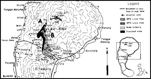 |
Figure 1. Map of Api Siau, showing the 1974 and 1976 lava flows and the 1976 nuée ardente deposits. Courtesy of VSI. |
Information Contacts: D. Hadikusumo, VSI.
Occasional explosions since October
Three explosions from the summit crater occurred during October and two others were observed at night during November and early December. Ashfalls reached Ulu, 6 km SE of the summit (figure 1), where ~0.5 mm of ash was deposited.
A 10-minute eruption beginning at 1730 on 15 December produced a thick tephra column that rose 600-700 m above the summit and dropped more than 0.5 mm of ash on Ulu. Sharp explosion sounds were clearly audible from the temporary observatory at Tarorane, about 5 km from the summit. Volcanic tremors were frequently felt, but none were recorded at Tarorane.
Vapor emission from the 1976 vents has stopped, but a solfatara ~ 50 m above the upper vent emitted a thin stream of bluish gas.
Information Contacts: A. Sudradjat, M. Kamid, VSI.
Explosion from new flank vent
On 31 May at about 0200 an explosion produced a new crater at about 1,300 m elevation on the NNW flank. A 600-m eruption column and a loud noise were reported. Gas emission from three vents in the new crater was continuing in mid-Aug and the 784 inhabitants of nearby villages remained on alert.
Information Contacts: A. Sudradjat, VSI.
Incandescent tephra from main crater
Incandescent tephra was ejected to 200 m above the main crater on 24 March at 1905. As of 27 March, no additional activity had been observed.
Information Contacts: A. Sudradjat, VSI.
Cauliflower-shaped cloud; incandescent tephra
A seismograph recorded an explosion . . . on 12 September at 0410. The next day at 1140, a cauliflower-shaped eruption column rose 1,200 m above the crater. Similar explosions had occurred on 3 July and three times in August, depositing incandescent tephra over an area 3 km in diameter.
Information Contacts: A. Sudradjat and L. Pardyanto, VSI.
Tephra ejection, lava flows, lahars; 20,000 evacuated
Press sources reported that explosions 28 August and 5 September ejected dense ash clouds that rose to 4 km altitude. Ash and larger tephra fell over a wide area. Lava flows and lahars destroyed terraced rice fields and nutmeg orchards on the volcano's upper flanks. Magnitude 3-5 earthquakes had been felt since the beginning of September. About 25 shocks were felt near the volcano on 5 September, and some were also felt on nearby islands. By late 11 September, about half of Siau Island's 40,000 residents had been evacuated and officials warned people living on the lower flanks to be ready to leave quickly.
Information Contacts: UPI; DPA; AFP.
Seismicity and minor tephra emission since January; ash column and nuées ardentes in September
An explosive eruption on 5 September was preceded by seismicity and nine months of minor tephra ejection. Rumblings were heard on 4 January, followed by an explosion that ejected ash. From February through April, rumbling preceded episodes of ash emission. On 31 May at 0724, an ash column rose to 1.5 km above the summit. During the night of 7-8 June, glowing lava fragments were ejected from the main crater. On 20 July, ash emission was accompanied by rumbling. The number of local seismic events increased through the first half of 1984 (table 1). Volcanic tremors were recorded 24 August, although no surface activity was seen. Ash emission occurred 3 September at 0447, producing an eruption column that rose 600 m. Glowing lava fragments were occasionally ejected. Rumbling accompanied the activity.
Table 1. Number of local earthquakes/month recorded at Karangetang. Courtesy of VSI.
| Date | Tectonic Earthquakes | Volcanic Earthquakes |
| Jan 1984 | 62 | 18 |
| May 1984 | 82 | 57 |
| Jun 1984 | 200 | 139 |
| Jul 1984 | 456 | 85 |
On 5 September at 0905, an ash column rose 4 km from the main crater. Nuées ardentes flowed 2 km S and 1 km W, with estimated volumes of 1.5 and 0.5 x 10⁶ m3. One week later, ash emission was continuing and weak rumbling was heard. Ten volcanic and five tectonic earthquakes were recorded daily through 16 September. About 4,500 people were temporarily evacuated from the S and W sides of the danger zone but were allowed to work in their fields during the day. No casualties were reported.
Information Contacts: A. Sudradjat, VSI.
Lava flow from S flank vent
A 4-day eruption began 24 February. Effusive material was erupted from a S flank new vent, about 300-400 m from the main crater. A lava flow extended ~350 m S (along the Batuawang River), stopping after four days. Inhabitants downslope of the lava flow were alerted, including the villages of Kola, Bola, and Kopi. Harmonic tremor indicated lava movement a few hours before effusive activity began, but no other significant changes in seismicity were detected during the activity.
Api Siau has been the site of nearly continuous activity for the last 20 years.
Information Contacts: A. Sudradjat, VSI.
Small ash eruption
"Api Siau erupted from the main crater (Kawah Utama) on 6 November. A 1.5-km-high ash column covered villages S of the volcano (Salili, Beong, Kanawong, and Lehi) with 1-3 mm of ash. Detonations were heard from the observation post at Muaralawa, 4.5 km SW of the volcano. Additional detonations were reported throughout the month. Possible precursory signs of this activity included a darkening of the normally whitish quiescent plume beginning on 4 November."
Information Contacts: T. Casadevall and L. Pardyanto, VSI.
Small gas plume in December
Api Siau was quiet during December with only a small gas plume continuing to be emitted.
Information Contacts: Suparto S. and T. Casadevall, VSI.
Small explosions
Three small explosions occurred during July, but no details were available.
Information Contacts: VSI.
Rumblings, but no more explosions reported
Rumblings from the volcano were heard during September. . . . no activity had been reported in August.
Information Contacts: VSI.
Flowing lava; white-gray plumes
White to sometimes gray emissions under low-medium pressure rose to 250 m above the crater, often accompanied by glowing lava that was clearly seen at night. Earthquakes of MM I-II were felt on 14 July at 2240, 22 July at 1323 and 26 July at 1915. The type and number of earthquakes recorded were: 45 distant tectonic, 20 local tectonic, and one degassing. The volcano's level of activity appeared to be decreasing and was lower than normal in late July.
Information Contacts: VSI.
Explosive activity and glow
Explosions were clearly visible from the coast (at Ulu Siau) during a visit 2-4 July. A diffuse, red, summit-area glow was continuously observed. Some small earthquakes were felt.
Information Contacts: V. Clavel and P. Vetsch, SVG, Switzerland.
Lava extrusion and incandescent tephra emission; pyroclastic flow kills six
A pyroclastic flow, triggered by collapse of a lava flow front, killed six people on 11 May.
After an increase in seismicity to as many as 4 events/week in April-May 1991, ash explosions began in the main central crater, ejecting incandescent projectiles to 50-75 m height (16:08). Strombolian activity lasted until August, when lava emission began in the main crater. During September, explosive activity decreased to ash emissions 25-75 m high, accompanied by audible explosions and some incandescence.
Activity increased in February 1992, and incandescent ash emissions became continuous. An estimated 6 x 10⁶ m3 of lava had accumulated in the crater and lava flows began to advance down the S flank's Kali Keting valley. On 2 March, VSI and local authorities warned farmers along the upper Kali Keting to be prepared for the possibility of collapse of the lava flow front and subsequent generation of pyroclastic flows. This region was designated on the 1989 VSI volcano hazard map as being at highest risk of destruction (by pyroclastic flows). At 1330 on 11 May, a pyroclastic flow caused by the collapse of the lava flow front traveled 4 km from the main crater down the Kali Keting, burning seven farmers (six of whom later died in hospitals) and destroying >30 houses and ~2 km2 of coconut, cassava, and nutmeg farms. The pyroclastic-flow deposit had a volume of ~1.2 x 10⁶ m3 (roughly 20% of the lava in the crater). The eruption was continuing as of 19 May, as indicated by the increasing number of volcanic earthquakes and seismically recorded degassing events (table 2).
Table 2. Monthly seismicity at Karangetang, February-19 May 1992. Courtesy of VSI.
| Date | Volcanic A-type | Volcanic B-type | Degassing | Tectonic local | Tectonic distant | Felt shocks |
| Feb 1992 | -- | -- | 12 | 221 | 289 | 4 |
| Mar 1992 | -- | -- | 345 | 101 | 252 | 1 |
| Apr 1992 | -- | -- | 253 | 150 | 158 | 2 |
| 1-19 May 1992 | 21 | 23 | 500 | 13 | 41 | 1 |
Information Contacts: W. Modjo, VSI; UPI.
Some decline in explosive activity, lava production, and seismicity, but glowing rockfalls advance 1.5 km
Activity began to increase in February 1992. Glowing rockfalls on 18 May filled the upper Keting river valley to 4 km from the crater. The volume of the deposit was estimated at 1.2 x 10⁶ m3, ~ 20% of the dome (17:04). Since then, the eruption has fluctuated, but a general decrease in intensity was indicated by declines in the height of the ash plume, the behavior of the glowing lava flow, and the vigor of incandescent tephra ejection. In July, glowing rockfalls advanced down the Keting river to 1,500 m from the crater. The number of volcanic and local tectonic earthquakes decreased in June and July compared to previous months. June-July seismicity was dominated by surface activity, such as explosion earthquakes and rockfalls (figure 2).
 |
Figure 2. Tectonic seismicity (top) and volcanic earthquakes (bottom) at Karangetang, June-July 1992. Courtesy of VSI. |
Information Contacts: W. Modjo, VSI.
Heavy rains prompt lahar warning
Heavy rainfall has recently occurred on the S flank, where six farmers were killed by a pyroclastic flow in May (17:04). Local authorities were officially warned of the lahar hazard to farmers in the area. Activity at the volcano has declined to normal levels since August.
Information Contacts: W. Modjo, VSI.
Ash ejection and hot lahars force evacuations
Activity began on 21 January [1993], when a hot mudflow was observed at 1714 flowing S along the Bahembang River to 4.5 km from the summit. The eruption of hot mud and ash forced the evacuation of 452 people. No casualties had been reported by 25 January, but a bridge linking the villages of Dame and Karanglung, ~4 km SSW, was destroyed by hot ashes. Ashfall was also reported 3-6 km SE and SSE of the summit (in the villages of Bubali, Salili, Panili, and Ondang). Official lahar warnings were issued in November after heavy rainfall on the S flank of the volcano . . . .
Information Contacts: ANS.
Ash ejection and hot lahars force evacuations; no casualities
This report provides additional information about the 21 January eruption described in 17:12. Activity increased at 2335, with ejection of incandescent lava fragments and gray ash clouds. The 21 January explosion was followed by rumbling sounds and ejection of lava fragments that avalanched 750 m down the Beha valley. The press reported that a hot mudflow was observed at 1714 flowing S along the Bahebang River to 4.5 km from the summit, forcing the evacuation of 452 people. No casualties were reported, but avalanches or nuées ardentes damaged two houses near the outlet of the Bahebang river on 21 January, and another five are threatened by rain-induced lahars. The press noted that a bridge linking the villages of Dame and Karanglung, ~ 4 km SSW, was destroyed by hot ashes, and ashfall was reported 3-6 km SE and SSE of the summit (in the villages of Bubali, Salili, Panili, and Ondang). Avalanches and rumbling noises were continuing as of 10 February.
Information Contacts: W. Tjetjep, VSI; ANS.
Description of fumaroles and morphology
"During observations at 1145 on 15 July from the SW flank, a white plume rose above the volcano and extended toward the E. Two active lava domes were present on the summit, one in the S, and the other in the NE. Each generated white plumes from its top. Many fumaroles with yellow sulfur deposits covered the S side of the NE dome. A small chaotic-looking lava flow was located near the foot of the NE lava dome. It was possible to hear weak, rhythmic explosions from an area located between the two lava domes behind the summit pass, but no direct observations were possible because of the cover of rising clouds."
Information Contacts: H. Gaudru, C. Pittet, M. Auber, C. Bopp, and O. Saudan, EVS, Switzerland.
Small ash plumes, incandescent ejecta, and increased seismicity
On 9 and 16 November "thunderclaps" were heard from the summit. A gray plume 500 m high was observed, and incandescent ejecta rose 10-50 m above the summit at night. On 17 December thunderclaps were heard again and ejecta rose 100 m above the summit. Seismicity increased from 26 October until the end of 1995. Daily counts of deep volcanic (A-type) earthquakes fluctuated up to 116 (figure 3).
 |
Figure 3. A-type seismicity at Karangetang, September-December 1995. Courtesy of VSI. |
Information Contacts: Wimpy S. Tjetjep (Director), Volcanological Survey of Indonesia (VSI), Jalan Diponegoro 57, Bandung, Indonesia.
October ash explosions and Strombolian eruptions
During October, Karengetang produced ash explosions and occasional Strombolian eruptions every day. These rose to several hundred meters above the crater rim. The eruptions resulted in pyroclastic materials accumulating on the summit, a situation that could lead to hazardous lahars in the rainy season.
Information Contacts: Wimpy S. Tjetjep, Volcanological Survey of Indonesia, Jalan Diponegoro No. 57, Bandung 40122, Indonesia.
Three people killed by a pyroclastic flow in June
On 17 April the Bureau of Meteorology in Darwin received a report from the Volcanological Survey of Indonesia of an ongoing eruption at Karangetang; however, the plume height could not be observed because of cloud cover, and no plume was seen in later satellite imagery. The Societe de Volcanologie de Geneve (SVG) reported that explosions and pyroclastic flows in June required the evacuation of 400 people from a village. They further reported that this eruptive episode claimed the lives of three people. The last reported activity consisted of daily ash explosions during October 1996.
Information Contacts: Bureau of Meteorology, Northern Territory Regional Office, P.O. Box 735, Darwin NT, Australia; Societe de Volcanologie Geneve (SVG), B.P. 298, CH-1225, Chenebourg, Switzerland.
Incandescent material ejected in early July
During early July observers noted incandescent materials at night. They also saw a plume emitted from the main crater rising to 25-50 m in height. Around this time, seismic events occurred less often compared to previous weeks.
Information Contacts: Volcanological Survey of Indonesia, Jalan Diponegoro No.57, Bandung 40122, Indonesia (URL: http://www.vsi.esdm.go.id/).
During March-May, weak ash emissions and rare incandescence
Between 9 March and 24 May, a "thick white ash plume" was emitted from the main crater and rose to 300-500 m, while a "thin white ash plume" rose to ~150 m from Crater II. Occasionally incandescence was seen in the column rising from the main crater to heights of 25 m. Some A-type earthquakes occurred throughout the reporting period, but seismicity was dominated by tectonic events that frequently exceeded 200/week.
Karangetang (Api Siau) lies at the northern end of the island of Siau, N of Sulawesi, and contains five summit craters strung along a N-S line. One of Indonesia's most active volcanoes, Karangetang has had more than 40 recorded eruptions since 1675. Twentieth century eruptions have included frequent explosions, sometimes accompanied by pyroclastic flows and lahars.
Information Contacts: Volcanological Survey of Indonesia (VSI), Jalan Diponegoro No. 57, Bandung 40122, Indonesia (URL: http://www.vsi.esdm.go.id/).
Ash emissions and crater glow continue
Ash emission and crater glow continued at Karangetang during the last week of May. Main Crater produced a column of thick white ash that rose 450 m above the summit. Glow was seen up to 75 m above the crater. Crater II produced a dull white column of ash 150 m in height. Tectonic events dominated the seismic record (figure 4).
 |
Figure 4. The number of volcanic and tectonic earthquakes recorded at Karangetang during June-September 1999. Data courtesy of VSI. |
This pattern of activity continued with minor changes in the height or density of ash columns at both craters and the intensity or height of glow seen at Main Crater until late in June. During early July, thick fog sometimes prevented observation of the summit. The pattern of thick ash columns rising a few hundred meters above the summit accompanied by glow up to 50 m above the summit resumed in mid-July and continued with a tendency to decreasing intensity until late September.
Information Contacts: Volcanological Survey of Indonesia (VSI), Jalan Diponegoro No. 57, Bandung 40122, Indonesia (URL: http://www.vsi.esdm.go.id/).
February-December included explosions, ash falls, lava flows, and debris flows
The following report covers activity during February to mid-December 2000. At the beginning of February, the main crater of Karangetang (also known as Api Siau) produced a light-colored ash emission that rose 250-350 m, while Crater II emitted a lighter ash plume to a height of 75-100 m. At night the ash column glowed red to a height of 10-25 m. Similar activity continued through May; variable-density emissions from the main crater rose to a maximum height of 500 m, those from Crater II rose up to 150 m, red illumination was visible up to 75 m at night, and rumbling was heard intermittently through May.
In mid-June tremor events with amplitudes of 0.5-10.5 mm dominated seismicity. Ash plumes continued to rise from both craters, and lava fountaining was observed at the main crater. A lava flow and a debris avalanche sent material up to 300 m from the summit down to the Bahembang River. Red summit illumination was visible at night. Another lava flow and debris avalanche occurred in late June, lava fountains reached 50 m above the summit at times, and the maximum amplitude for tremor was 33 mm in early September. Relatively similar activity persisted through the end of the month.
During mid-October, activity increased significantly. The two craters continued to emit light-colored, variable-density ash plumes, and thundering could be heard. At 1840 on 14 October, observers saw lava flowing 100 m down to the Nenitu River. Lava avalanches traveled up to 1,000 m from the summit. Seismicity increased notably with many A-type earthquakes, tectonic earthquakes, explosive events, and continuous tremor. At 1131 on 27 October, a small explosion sent a dark ash plume to a height of 1 km. An ash cloud drifted E to the sea, while pyroclastic flows burned vegetation along their paths and reached ~1,500 m down the E, W, and S flanks. During this period, multi-phase earthquakes occurred and tremor became discontinuous.
Another explosion at 2030 on 2 November sent dark ash 1.5 km above the summit. Ashfall and pyroclastic flows occurred along the flanks; ash followed a similar pattern of distribution as after the 27 October explosion. Seismicity quieted slightly following this explosion. A smaller explosion occurred on 11 November and dark ash rose 600 m. Ash fell around the summit area, and no injuries were reported. Red illumination at night and frequent booming sounds accompanied ash plumes that continued to rise from the main crater and Crater II during October-November.
Seismicity increased by 12 December with nearly fifteen times as many multi-phase earthquakes as in late November, and the resumption of continuous tremor. Thundering sounds continued to be heard often, and red summit illumination could be observed occasionally at night. The main crater and Crater II emitted a light-colored, variable-density ash plume to 150 m above Karangetang's summit. The volcano maintained a hazard status of 2 (on a 1-4 scale) during the report period.
Information Contacts: Dali Ahmad, Volcanological Survey of Indonesia (VSI), Jalan Diponegoro No. 57, Bandung 40122, Indonesia (URL: http://www.vsi.esdm.go.id/).
Explosions generate ash plumes, ashfall, lava flows and avalanches
Heightened activity continued at Karangetang in late December 2000-late January 2001, following a year of frequent activity in 2000 (BGVN 25:11). The main crater and Crater II sent a white, variably-thick ash plume up to 600 m above the summit during 19-25 December. Plume illumination up to 150 m above the craters was visible at night. Lava flows occurred on 21-22 December and reached as far as 1,250 m laterally along the SW flank. The seismic record also showed increased activity with multi-phase earthquakes predominating.
Activity, however, tailed off during 26 December-1 January before increasing again with renewed vigor from 2 to 8 January. At 1258 on 2 January an explosion produced a white-gray ash plume that rose ~500 m above the summit. At 1845 on the same day, workers observed a glowing lava avalanche issuing from the main crater and moving 50 m from the summit down toward the Naitu River. A larger explosion on 7 January sent gray ash 1,500 m above Karangetang. A coeval Strombolian eruption cloud rose 200 m. Ashfall occurred W of the volcano, coating Pahe, Lehi, Mini, and Kinali villages. Lava flowed down to the Tanitu River as far a 1 km from the summit. Tectonic earthquakes dominated seismicity during the week, and a significant number of tremor earthquakes also occurred.
A minor explosion occurred on 10 January; ash rose and subsequently fell back into the crater. Tectonic earthquakes again overshadowed all other types during 9-15 January. At 0845 on 17 January an explosion generated a small ash plume and a lava avalanche. Ash fell on Salili and Beong villages; lava flowed down both the E and W flanks of the volcano. Seismicity remained elevated with earthquake distributions similar to the previous week. The VSI maintained a hazard status of 2 (on a scale of 1-4) for Karangetang throughout the report period.
Information Contacts: Dali Ahmad, Volcanological Survey of Indonesia (VSI), Jalan Diponegoro No. 57, Bandung 40122, Indonesia (URL: http://www.vsi.esdm.go.id/).
Explosions in late January 2001 eject ash and lava
Eruptive activity at Karangetang since the previous report (BGVN 25:12) continued through 5 February 2001. A minor explosion occurred at 2227 on 25 January and produced an ash-heavy plume that rose 700 m; ash fell into the sea W of the volcano. The eruption also featured a molten lava avalanche that flowed down to the Kelitu River with a maximum runout distance of ~1,250 m from the summit. At 2109 on 28 January a second, Strombolian-style explosion occurred that sent glowing ejecta 300 m above the crater; a black ash cloud rose 1 km and ashfall was observed on a nearby beach. The 28 January eruption also sent lava avalanches ~1,500 m down Karangetang's W flank. Seismicity for the period 23-29 January was dominated by multi-phase earthquakes.
During 30 January-5 February no significant visual activity was observed; multi-phase earthquakes outnumbered all others during the week. VSI maintained a hazard status of 2 (on a scale of 1-4) for Karangetang, and no further eruptive episodes were reported.
Information Contacts: Dali Ahmad, Volcanological Survey of Indonesia (VSI), Jalan Diponegoro No. 57, Bandung 40122, Indonesia (URL: http://www.vsi.esdm.go.id/).
April-October activity includes lava flows, lava avalanches, and ash plumes
The frequent, but spasmodic, activity witnessed during 2000 and the early part of 2001 at Karangetang quieted somewhat between mid-February and mid-April, although the Alert Level remained at 2 (on a scale of 1-4). During late April and early May, the Volcanological Survey of Indonesia (VSI) reported lava flowing from the crater. Lava avalanches that originated at the end of the lava flow traveled 750 m to the Nanitu River. A likely ash plume rose 50-300 m above the main crater and a steam cloud from Crater II rose 200 m above the summit. Plume illumination was visible 25-75 m above the volcano.
Volcanic activity continued at high levels after eruptions on 25 and 29 June. During early July, seismographs registered small explosions, avalanches, and an average of 33 earthquakes/day. A gray plume was emitted. As a result of this increased activity, the Alert Level was raised to 3. During the remainder of July and August, explosions, avalanches, and earthquakes continued to dominate seismicity. During 9-15 July, there were 572 explosions, 451 earthquakes, and continuous lava avalanches; one avalanche traveled 2.5 km down the Keting River and lava flowed 750 m down the Kahetang River. On 10 August, cold lahars crossed roads as they traveled down the Batu Awang and the Kahetang Rivers.
Similar seismic activity, lava flows, and lava avalanches continued into mid-September. On 9 September, a pyroclastic flow traveled as far as 750 m from the main crater to the Batang River (West Siau). During 10-16 September, the number of lava flows and avalanches decreased. Lava flowed 1.5 km down the Kahetang and Keting rivers, and avalanches extended 1 km. Small explosions and earthquakes continued, while emissions of steam and possibly ash at the N main crater rose to 0.5 km above the summit. During the rest of September, seismicity decreased, and lava flows and avalanches were rare.
Deep volcanic earthquakes increased during early October, and during 1-2 October incandescent lava avalanches traveled from the main crater and steam plumes rose 600 m above the main crater and 50-150 m above Crater II. Plume illumination was observed to 50 m above the volcano. The Alert Level was reduced to 2 because of the decrease in deep earthquake activity that occurred the following week.
During 22-28 October, the number of deep volcanic earthquakes increased but no seismicity associated with eruptive activity was recorded. White plumes continued to rise above the main crater and Crater II, plume illumination was observed above the crater, and multi-phase earthquakes, associated with lava-dome growth, were detected. On 29 October a minor explosion from Crater IV produced a gray cloud that rose 1.5 km above the crater. As of the end of October, the Alert Level remained at 2.
Information Contacts: Dali Ahmad, Volcanological Survey of Indonesia (VSI), Jalan Diponegoro No. 57, Bandung 40122, Indonesia (URL: http://www.vsi.esdm.go.id/).
Lahars cause damage in January; explosions and lava flows in February
During 5 November 2001 through 24 February 2002, seismicity continued at Karangetang, and plumes were observed rising above the summit (table 3). The lava flows that began during late April and early May 2001 (see BGVN 26:10) stopped around 25 October. Multiphase earthquakes, associated with lava dome growth, had not been registered since September but began again during early November.
Table 3. Seismicity and plumes observed at Karangetang during 5 November through 24 February. The Alert Level remained at 2 throughout this period. Courtesy VSI.
| Date | Deep volcanic (A-type) | Shallow volcanic (B-type) | Tectonic | Multiphase | Observation (plume heights are above summit) |
| 05 Nov-11 Nov 2001 | 7 | -- | 51 | 11 | White medium-thick plume rose 100 m above N crater, 50 m above crater II; incandescence to 20 m |
| 12 Nov-18 Nov 2001 | 14 | 4 | 49 | -- | White medium-thick plume rose 600 m; incandescence to 25-50 m |
| 19 Nov-25 Nov 2001 | 12 | 9 | 36 | -- | -- |
| 26 Nov-02 Dec 2001 | 14 | 2 | 66 | 5 | White medium-thick plume rose 300 m above main crater, 150 m above crater II |
| 03 Dec-09 Dec 2001 | 13 | 9 | 45 | 11 | White thin-medium plume rose 50-250 m above main crater, 100 m above crater II |
| 17 Dec-30 Dec 2001 | 17 | 16 | 60 | 12 | White medium-thick plume rose 500 m above main (S) crater, 50 m above crater II |
| 30 Dec-06 Jan 2002 | 10 | 5 | 9 | 7 | Lahars on 3 January |
| 07 Jan-13 Jan 2002 | 18 | 8 | 56 | 9 | White medium-thick plume rose 400 m above summit, incandescence inside the plume to 50 m |
| 14 Jan-20 Jan 2002 | 4 | 7 | 44 | 1 | -- |
| 21 Jan-27 Jan 2002 | 4 | 6 | 29 | 6 | -- |
| 28 Jan-03 Feb 2002 | 8 | 1 | 36 | 12 | White medium-thick plume rose 100 m above main (S) crater, 75 m above N crater; incandescence to 25 m |
| 04 Feb-10 Feb 2002 | 407 | 215 | 967 | 23 | Incandescence to 25 m |
| 11 Feb-17 Feb 2002 | 281 | 73 | 102 | 3 | Ash to WSW, lava flows, incandescence to 25 m |
| 18 Feb-24 Feb 2002 | 113 | 16 | 100 | 1 | Incandescence to 25 m |
During the first days of 2002 heavy rains near the summit resulted in cold lahars along the Kahetang river on the E flank. On 3 January around 1200 a lahar traveled ~260 m and was ~10-125 cm thick near Terminal and Pelabuhan Ulu Siau. The volume of the lahar was estimated to reach 40,000 m3. In this area, a total of 52 houses were destroyed. Near Bebali village, a lahar traveled ~60 m and covered the road along Ulu Siau city to Ondong village to a thickness of ~75 cm. The volume of the lahar was estimated at 600 m3. In this area, 9 houses and a church were damaged.
Seismicity increased during early February, and a thundering sound was heard frequently coming from the main (S) crater, often accompanied by a sulfur smell. During a 3-day period in early February, 82 earthquakes occurred with magnitudes of 1-3. The earthquakes often caused sliding of the unstable 2001 lava. On 11 February, an explosion occurred that produced ash falls 0.5-1 mm thick to the WSW, reaching the Kanawong, Lehi, Mimi, Kinali, and Pehe villages. Incandescent lava flows traveled up to 1.5 km down the Beha river (W slope) and Kahetang river (E slope). Seismicity was still high but decreased after the 11 February explosion. Loud noises, sulfur smells, and incandescence were observed through at least 24 February.
Information Contacts: Dali Ahmad, Volcanological Survey of Indonesia (VSI), Jalan Diponegoro No. 57, Bandung 40122, Indonesia (URL: http://www.vsi.esdm.go.id/).
Small explosions and increased seismicity during April 2002
During 25 February through at least 16 June 2002, seismicity at Karangetang was dominated by shallow volcanic (B-type) and tectonic earthquakes (table 4). Thick, white, medium-pressure plumes were typically emitted from the main crater (S) and reached 50-500 m above the crater rim. During late May through at least 16 June, a thin-medium white plume was emitted from crater II (N) and reached 150-200 m above the crater rim. During most of the report period a red reflection was observed around the summit at night, rising 10-75 m.
Table 4. Earthquakes recorded at Karangetang during 25 February through 16 June 2002. The Alert Level remained at 2 throughout this period. Courtesy VSI.
| Date | Deep volcanic (A-type) | Shallow volcanic (B-type) | Multiphase | Tectonic |
| 25 Feb-02 Mar 2002 | 52 | 5 | 6 | 62 |
| 03 Mar-10 Mar 2002 | 44 | 20 | 2 | 201 |
| 11 Mar-17 Mar 2002 | 29 | 8 | 9 | 100 |
| 18 Mar-24 Mar 2002 | 15 | 8 | 6 | 83 |
| 25 Mar-31 Mar 2002 | 20 | 9 | 2 | 112 |
| 01 Apr-07 Apr 2002 | 27 | 3 | 2 | 71 |
| 08 Apr-14 Apr 2002 | 17 | 64 | -- | 82 |
| 15 Apr-21 Apr 2002 | 26 | 74 | -- | 147 |
| 22 Apr-28 Apr 2002 | 17 | 61 | 2 | 146 |
| 29 Apr-05 May 2002 | 28 | 99 | 6 | 139 |
| 06 May-12 May 2002 | 22 | 70 | 0 | 132 |
| 13 May-19 May 2002 | 8 | 77 | 1 | 112 |
| 20 May-26 May 2002 | 22 | 93 | 6 | 146 |
| 27 May-02 Jun 2002 | 18 | 1228 | 4 | 113 |
| 03 Jun-09 Jun 2002 | 13 | 119 | 3 | 75 |
| 10 Jun-16 Jun 2002 | 12 | 62 | 1 | 45 |
Several eruptions occurred during the report period. An eruption on 5 March at 1344 emitted ash that reached 1.5 km above the summit. Ash fell on the NE flank and a lava avalanche also occurred. During the week of 3-10 March, 1 earthquake was felt. On 23 March 2002 at 1115 a thundering sound was heard from main crater, followed by a lava avalanche that flowed down to Kahetang and Batu Awang rivers. A thundering sound was heard beginning at 1615 on 28 March until 2007 on 29 March. No lava avalanches occurred during this time, but 3 earthquakes were felt during the last week of March. A medium explosion on 7 April at 2115 emitted thick gray ash to ~400 m above the crater rim.
The number of deep and shallow volcanic earthquakes increased during April (table 4). An ash explosion on 12 May at 1116 emitted ash that reached 750 m above the crater before falling to the sea on the E side. The explosion was followed by a lava avalanche that flowed ~500 m down the Batu Awang and Kahetang rivers. An explosion on 26 May at 1747 emitted white-gray ash that reached 300 m above the crater rim before falling to the sea on the W side. During 3-9 and 10-16 June, 2 and 5 small explosions occurred per week, respectively. Karangetang remained at Alert Level 2 throughout the report period.
Information Contacts: Dali Ahmad, Volcanological Survey of Indonesia (VSI), Jalan Diponegoro No. 57, Bandung 40122, Indonesia (URL: http://www.vsi.esdm.go.id/).
Shallow volcanic and small explosion earthquakes through early September
During 17 June-8 September 2002, seismicity at Karangetang was dominated by shallow volcanic (B-type) and small explosion earthquakes (table 5). The volcano's two currently active craters, the main crater and crater II lie to the S and N, respectively. The main crater nearly always issued white, medium-thick ash plumes that reached up to 500 m above the rim. The Alert Level remained at 2 throughout the report period.
Table 5. Earthquakes recorded at Karangetang during 17 June through 8 September 2002. "Plume details" compile visual observations from an observatory post at Salili, a village on the upper S flank. The plume from the main crater was nearly always described as "white, medium-thick" unless noted otherwise (as on 7-8 September). The plume from crater II was typically described as a "white ash plume" (exceptions noted). As noted in the text, the Alert Level remained at 2 throughout this period. Courtesy VSI.
| Date | Deep volcanic (A-type) | Shallow volcanic (B-type) | Multiphase | Small explosion/emission | Tectonic | Plume Details (heights are above the summit) |
| 17 Jun-23 Jun 2002 | 25 | 121 | 5 | 14 | 73 | Plume emitted from main crater reached 350 m; plume from crater II rose 50 m; red reflection reached 25 m. |
| 24 Jun-30 Jun 2002 | 17 | 166 | 0 | 10 | 97 | Plume emitted from main crater reached 200 m; plume from crater II rose 50 m; red reflection reached 25 m. |
| 01 Jul-07 Jul 2002 | 8 | 106 | 1 | 3 | 80 | Ash plume from main crater reached 100 m, light plume also observed, but not clearly. Ash plume from crater II rose 25 m. |
| 08 Jul-14 Jul 2002 | 64 | 144 | 0 | 4 | 78 | Medium-thick ash plume from main crater reached 100 m; light plume also observed reaching 10 m. Thin ash plume from crater II rose 50 m. One explosion event. |
| 15 Jul-21 Jul 2002 | 8 | 45 | 5 | 24 | 77 | Medium-thick ash plume from main crater reached 500 m; light plume also observed reaching 10 m. Thin ash plume from crater II rose 250 m. One explosion event. |
| 22 Jul-28 Jul 2002 | 75 | 122 | 4 | 20 | 89 | Ash plume from main crater reached 350 m; light plume also observed reaching 10 m. Thin ash plume from crater II rose 250 m. Two explosion events. |
| 29 Jul-04 Aug 2002 | 4 | 31 | 2 | 13 | 77 | Ash plume from main crater reached 400 m; light plume also observed reaching 25 m. Thin ash plume from crater II rose 200 m. |
| 05 Aug-11 Aug 2002 | 11 | 54 | 0 | 9 | 95 | Ash plume from main crater reached 400 m; light plume also observed reaching 25 m. Thin ash plume from crater II rose 200 m. |
| 12 Aug-18 Aug 2002 | 12 | 27 | 22 | 46 | 77 | Ash plume from main crater reached 150 m; light plume also observed reaching 25 m. Thin ash plume from crater II rose 50 m. |
| 19 Aug-25 Aug 2002 | 64 | 106 | 129 | 216 | 36 | Ash plume from main crater reached 150 m; light plume also observed reaching 25 m. Thin ash plume from crater II rose 50 m. |
| 26 Aug-01 Sep 2002 | 28 | 70 | 128 | 436 | 31 | Ash plume from main crater reached 150-200 m; thin-medium ash plume from crater II rose 25 m. |
| 02 Sep-08 Sep 2002 | 7 | 28 | 2 | 586 | 30 | Ash plume from main crater reached 300-400 m; thundering sounds during 7-8 September were accompanied by a gray ash plume from main crater. Thin ash plume from crater II rose 25 m. |
The Volcanological Survey of Indonesia (VSI) reported several explosions. On 8 July at 1806 a loud explosion from the main crater produced a white-gray ash plume that rose 1.0 km. Ash from the explosion spread NNW, while incandescence on the W flank burned vegetation. On 15 July at 1355 another loud explosion from the main crater produced white-gray ash that rose 1.5 km and spread N. A lava avalanche that accompanied the explosion entered the valley of the Kahetang river as far as 1.5 km. Multiphase earthquakes were recorded 5 times on 20 July. On 26 July at 0042 a very loud explosion heralded a lava avalanche to the W and partly to the E. The next day, at 1403, another explosion produced a lava avalanche in the same direction. The height of the ash from the explosion could not be determined because thick fog covered the edifice. Several felt tectonic earthquakes took place on 24 July, at 1014, 1839, and 1840 (intensity III on the modified Mercalli scale). Afterwards, there was a significant increase in seismic activity, mostly in deep- and shallow-volcanic earthquakes. Deep volcanic earthquakes increased from two on 23 July prior to the felt earthquakes to 58 on 24 July, while shallow volcanic earthquakes increased from 8 to 69. On 26 and 27 July, two avalanche earthquakes were recorded.
Information Contacts: Volcanological Survey of Indonesia (VSI), Jalan Diponegoro No. 57, Bandung 40122, Indonesia (URL: http://www.vsi.esdm.go.id/).
500-m plumes and ~ 1.5-km glowing lava avalanche; Alert Level increased
During September-29 December 2002, seismicity at Karangetang was dominated by emission, multiphase and tectonic earthquakes (table 6). The S crater nearly always issued "white, thin ash plumes" that reached up to 500 m above the rim. At night, a light plume was visible rising 25-100 m. Loud noises were heard frequently, and the N crater emitted a "thin white ash plume" to 50 m. No ashfall was reported.
Table 6. Earthquakes recorded at Karangetang during 9 September-29 December 2002. No reports were issued for Karangetang during 25 November-22 December. Courtesy VSI.
| Date | Deep volcanic (A-type) | Shallow volcanic (B-type) | Explosion | Multiphase | Emission | Tectonic | Avalanche |
| 09 Sep-15 Sep 2002 | 14 | 24 | 0 | 94 | 299 | 46 | -- |
| 16 Sep-22 Sep 2002 | 28 | 27 | 0 | 82 | 246 | 39 | -- |
| 23 Sep-29 Sep 2002 | 22 | 26 | 1 | 20 | 116 | 75 | -- |
| 30 Sep-06 Oct 2002 | 14 | 4 | 0 | 38 | 88 | 54 | 98 |
| 07 Oct-13 Oct 2002 | 19 | 13 | -- | 30 | 67 | 89 | 43 |
| 14 Oct-20 Oct 2002 | 7 | 22 | 1 | 30 | 146 | 34 | 10 |
| 21 Oct-27 Oct 2002 | 12 | 34 | -- | 23 | 114 | 65 | -- |
| 28 Oct-03 Nov 2002 | 18 | 154 | -- | 147 | 49 | 24 | -- |
| 04 Nov-10 Nov 2002 | 15 | 29 | -- | 90 | 21 | 69 | -- |
| 11 Nov-18 Nov 2002 | 12 | 40 | 1 | 75 | 28 | 70 | -- |
| 19 Nov-24 Nov 2002 | 15 | 116 | -- | 94 | 1 | 46 | -- |
| 23 Dec-29 Dec 2002 | 10 | 26 | 1 | 168 | 17 | 25 | -- |
During 9 September-13 October glowing avalanches flowed 25-250 m toward Nanitu river (West Siau), and toward Beha river as far as 400 m from the crater rim. By the week of 14-20 October, the lava avalanches extended ~1.5 km toward the Nanitu river, 1.0 km toward the Beha river (West Siau), and 750 m toward the Kahetang river.
On 12 September loud noises were accompanied by a 50-m-high gray ash plume. During 5-6 October, there were 2 volcanic tremor events. On 19 October at 1759 an explosion ejected glowing material to a height of 500 m; it landed inside the crater. A gray-black ash plume reached up to 750 m, drifted to the N, and fell on the sea.
Activity decreased during November, and loud sounds were rarely heard. On 15 November at 0248 an ash explosion produced glowing material up to ~200 m that fell around the crater. Some of the material entered the Batang, Beha, and Keting rivers, located 300-350 m away. Ash fell around Salili, Beong, Hiu, Ondong, Pehe, and Paniki villages to the SW. The Alert Level remained at level 3 through at least 29 December (on a scale of 1 to 4).
Information Contacts: Volcanological Survey of Indonesia (VSI), Jalan Diponegoro No. 57, Bandung 40122, Indonesia (URL: http://www.vsi.esdm.go.id/).
Ash explosions from January through May 2003
During 6 January-4 May 2003 explosions produced ash that fell on various parts of the crater. The S (main) crater emitted "white-gray ash" that reached 150-400 m high. On some nights, a red glow was visible reaching 25-50 m over the crater. The N crater emitted a "white-thin ash" plume that reached 50-300 m high. Fluctuating seismicity was dominated by multiphase earthquakes and emissions (table 7). The Alert Level remained at level 3 (on a scale of 1 to 4) through at least 4 May.
Table 7. Seismicity at Karangetang during 6 January-4 May 2003. Courtesy VSI.
| Date | Deep volcanic (A-type) | Shallow volcanic (B-type) | Explosion | Multiphase | Emission | Tectonic | Avalanche |
| 06 Jan-12 Jan 2003 | 11 | 16 | 2 | 178 | 178 | 28 | -- |
| 13 Jan-19 Jan 2003 | 9 | 16 | 2 | 133 | 42 | 40 | -- |
| 20 Jan-26 Jan 2003 | 12 | 37 | -- | 189 | 52 | 27 | -- |
| 27 Jan-02 Feb 2003 | 6 | 28 | 1 | 228 | 118 | 22 | -- |
| 03 Feb-09 Feb 2003 | 17 | 84 | 1 | 162 | 306 | 23 | -- |
| 10 Feb-16 Feb 2003 | 9 | 30 | 1 | 85 | 102 | 16 | -- |
| 17 Feb-23 Feb 2003 | 9 | 46 | -- | 97 | 8 | 32 | -- |
| 24 Feb-02 Mar 2003 | 48 | 68 | -- | 78 | 17 | 34 | -- |
| 03 Mar-09 Mar 2003 | 19 | 29 | 1 | 48 | 9 | 24 | 398 |
| 10 Mar-16 Mar 2003 | 14 | 11 | -- | 27 | 7 | 30 | 125 |
| 17 Mar-23 Mar 2003 | 24 | 145 | -- | 82 | 4 | 23 | 4 |
| 24 Mar-30 Mar 2003 | 21 | 68 | -- | 35 | 1 | 33 | 2 |
| 31 Mar-06 Apr 2003 | 8 | 83 | -- | 30 | -- | 36 | -- |
| 07 Apr-13 Apr 2003 | 18 | 143 | -- | 116 | 6 | 50 | -- |
| 14 Apr-20 Apr 2003 | 12 | 257 | 32 | 226 | 26 | 32 | 7 |
| 21 Apr-27 Apr 2003 | 13 | 373 | 2 | 93 | 6 | 17 | 309 |
| 28 Apr-04 May 2003 | 32 | 255 | -- | 243 | 1 | 21 | 29 |
On 11 and 12 January, ash explosions at the S crater were accompanied by glowing material that reached 200 m high and scattered 500 m toward the E and W parts of the crater. An ash column rose up to 500 m above the crater. Two explosions at the S crater on 14 January produced an ash column up to 300 m high; glowing material rose up to 50 m and fell around the crater. Some of the material entered the Beha River, and ash fell into the sea E of the island. Explosions on 29 January and 6 February caused ashfall SW (Beong village) and SSW (Akesembeka village, Tarurane, Tatahadeng, Bebali, and Salili), respectively. A booming noise was heard frequently throughout the report period, and during early February was sometimes accompanied by thick gray emissions up to 350 m above the crater.
Beginning in early March, the booming noise was accompanied by glowing lava avalanches that traveled from the summit towards the Kahetang (1,250 m), Batuawang (750 m), Batang (1,000 m), and Beha (750 m) rivers. On 6 March an explosion from the S crater ejected ash 750 m high that fell in the E part of the crater. The noises and avalanches decreased during mid-to-late March.
An explosion on 15 April was followed by lava avalanches toward the W and S parts of the crater. A loud blasting sound was heard, and a dark-gray ash column reached 1,500 m. Ash fell to the E around Dame and Karalung villages, and over the sea. Lava avalanches from the S crater traveled 1,000 m toward the Batang and Batu rivers. On 20 April another explosion produced a 1,500-m-high ash column, and ash fell E over the sea. This explosion was followed by lava avalanches and a pyroclastic flow toward the Batang river that reached as far as 2,500 m. Lava avalanches extended 1,500 m down the S and W slopes. Blasting noises occurred for about 3 minutes.
On 22 April an explosion ejected ash and glowing material. The ash column reached 1,750 m and ash fell on the W slope, including Lehi, Mini, Kinali, and Hiung villages, while glowing material rose up to 750 m. This explosion was followed by lava avalanches towards the W and S that were accompanied by a pyroclastic flow toward the Batang river that extended 2,250 m. On 24 April, an explosion ejected ash to 750 m and ash fell eastward into the sea. Glowing material from the explosion traveled toward the W slope. During late April, the booming noises were once again accompanied by continuous glowing avalanches. These decreased during the first days of May.
Information Contacts: Volcanological Survey of Indonesia (VSI), Jalan Diponegoro No. 57, Bandung 40122, Indonesia (URL: http://www.vsi.esdm.go.id/).
June 2003 ash plumes and two lava avalanches
Karangetang was the scene of volcanic and seismic unrest during early June 2003. The volcano produced ash plumes up to 400 m high and two lava avalanches.
In reports from the Volcanological Survey of Indonesia (VSI), activity for the week of 2-8 June 2003 was characterized by emissions of white-to-dark gray colored ash from the S crater, rising to 400 m. Observers at night noted a red glow up to 25 m over the crater. In the N crater, a white-colored gas emission rose to 150 m. During this week, a lava avalanche that occurred in the direction of the Batang river reached as far as 1000 m from the crater. There was a decrease in multiphase earthquakes compared to the previous week, but an increase in shallow volcanic earthquakes.
During the week of 9-15 June, white-colored gas emissions came from both the N and the S craters. Observers at night noted a continued red glow up to 25 m over the crater. Another lava avalanche occurred, this time traveling in the direction of the Beha river as far as 1000 m and toward the Batu Awang river as far as 250 m from the crater. There were increases in volcanic earthquakes and avalanche events.
The seismic record for 2-8 June suggested 11 deep volcanic earthquakes, 348 shallow volcanic earthquakes, 233 multiphase earthquakes, 46 emission earthquakes, 110 avalanches, and 26 tectonic earthquakes. The seismic record for 9-15 June noted 32 deep volcanic earthquakes, 438 shallow volcanic earthquakes, one explosion event, 228 multiphase earthquakes, 21 emission earthquakes, 447 avalanches, and 20 tectonic events. The volcano remained at alert level 2 (on a scale reaching a maximum of 4).
Information Contacts: Dali Ahmad and Nia Haerani, Volcanological Survey of Indonesia (VSI), Jalan Diponegoro No. 57, Bandung 40122, Indonesia (URL: http://www.vsi.esdm.go.id/).
Ash explosions and lava avalanches in July; overall activity level declines
Ash explosions have been frequent at Karangetang during 2003 (BGVN 28:05 and 28:07). A red glow at night and lava avalanches were reported during 9-15 June (BGVN 28:07). Although detailed observations were not provided by the Volcanological Survey of Indonesia (VSI) for the next two weeks, the hazard status remained at Alert Level 2 (on a scale of 1-4).
VSI weekly reports from 30 June through 3 August indicated that white gas plumes from the S crater typically rose 350-500 m above the crater rim, night glow often extended 25 m above the crater, and white gas plumes from the N crater rose as high as 350 m. Seismic data showed that lava avalanches and shallow volcanic earthquakes in early July were significantly reduced compared to the first half of June (table 8).
Table 8. Seismicity at Karangetang during 2 June-28 September 2003. VSI did not issue reports for Karangetang during weeks not included in the table; a dash indicates no data reported. Courtesy of VSI.
| Date | Deep volcanic (A-type) | Shallow volcanic (B-type) | Explosion | Multiphase | Emission | Avalanche | Tectonic |
| 02 Jun-08 Jun 2003 | 11 | 348 | -- | 233 | 46 | 110 | 26 |
| 09 Jun-15 Jun 2003 | 32 | 438 | 1 | 228 | 21 | 447 | 20 |
| 30 Jun-06 Jul 2003 | 15 | 93 | -- | 446 | 11 | 32 | 11 |
| 07 Jul-13 Jul 2003 | 15 | 93 | -- | 534 | 22 | 35 | 7 |
| 14 Jul-20 Jul 2003 | 21 | 174 | 31 | 672 | 38 | 45 | 22 |
| 21 Jul-27 Jul 2003 | 17 | 112 | 9 | 94 | 131 | 66 | 25 |
| 28 Jul-03 Aug 2003 | 10 | 8 | -- | 312 | 174 | 94 | 10 |
| 01 Sep-07 Sep 2003 | 8 | 44 | 1 | 80 | 341 | 1 | 20 |
| 08 Sep-14 Sep 2003 | 5 | 14 | 0 | 50 | 266 | 5 | 23 |
| 15 Sep-21 Sep 2003 | 6 | 90 | 0 | 3 | 16 | 0 | 74 |
| 22 Sep-28 Sep 2003 | 9 | 60 | 0 | 75 | 130 | 0 | 37 |
During 18-20 July there were ash-producing explosions and lava avalanches. On 21-22 July an ash explosion produced a 150-m-high ash column and a glowing lava avalanche flowed 350 m toward the Beha river. During the week of 28 July-3 August another glowing lava avalanche flowed 1,500 m toward the Beha river and 350 m toward the Batang river. On 29 July volcanic tremor was recorded with a maximum amplitude of 0.5-2 mm.
Karangetang was not included in August reports, but the report for 1-28 September noted white gas emissions from the S crater rising 150-350 m and red glow at night reaching 25 m over the crater, with the N crater exhibiting white gas emissions to 50-150 m above the crater. There were no lava avalanches during this period. The Alert Level remained at 2.
Information Contacts: Dali Ahmad, Hetty Triastuty, and Nia Haerani, Volcanological Survey of Indonesia (VSI), Jalan Diponegoro No. 57, Bandung 40122, Indonesia (URL: http://www.vsi.esdm.go.id/).
White gas emissions and glow during October, but decreased seismicity
Explosive activity has been common at Karangetang in recent years, producing ashfall and lava avalanches as recently as May and June 2003 (BGVN 28:05 and 28:07). However, Karangetang was not included in reports by the Volcanological Survey of Indonesia (VSI) between 16 June and 28 September 2003. A report for the week of 29 September-5 October indicated that there had been a decrease in multiphase and emissions earthquakes compared to the previous week (table 9). At that time white gas emissions were observed rising 400 m above the S crater and 50 m above the N crater. Red glow was seen at night over the S crater that week. No lava avalanches occurred. Similar observations were reported through 19 October. Although surface observations of activity were consistent, seismic data showed that shallow volcanic earthquakes increased and emission events decreased during 6-19 October. The hazard status remained at Alert Level 2 (on a scale of 1-4) through at least 19 October.
Table 9. Seismicity at Karangetang during 2 June-19 October 2003. No data was available between 16 June and 28 September. Courtesy of VSI.
| Date | Deep volcanic (A-type) | Shallow volcanic (B-type) | Multiphase | Emission | Tectonic |
| 02 Jun-08 Jun 2003 | 11 | 348 | 233 | 46 | 26 |
| 09 Jun-15 Jun 2003 | 32 | 438 | 228 | 21 | 20 |
| 29 Sep-05 Oct 2003 | 15 | 84 | 50 | 121 | 38 |
| 06 Oct-12 Oct 2003 | 19 | 103 | 33 | 74 | 32 |
| 13 Oct-19 Oct 2003 | 18 | 135 | 54 | 72 | 33 |
Information Contacts: Dali Ahmad, Hetty Triastuty, Nia Haerani, and Suswati, Volcanological Survey of Indonesia (VSI), Jalan Diponegoro No. 57, Bandung 40122, Indonesia (URL: http://www.vsi.esdm.go.id/).
Ash explosion on 28 October, then decreased seismicity
White gas emissions and glow were reported at Karangetang during October 2003. The Volcanological Survey of Indonesia (VSI) reported continuing activity over the period 26 October-30 November, with white gas plumes rising 350-400 m above the S crater rim and 50-150 m above the N crater. On 28 October an ash explosion produced a 2,000-m-high column with ashfall reaching the sea to the E and a lava avalanche toward the Batu Awang area, 750 m from the summit. Except for the week of 17-23 November, local seismicity decreased compared to the first half of October (table 10). The hazard status remained at Alert Level 2 (on a scale of 1-4).
Table 10. Seismicity at Karangetang during 27 October-30 November 2003. One explosion and one avalanche also occurred during the week of 27 October-2 November. Courtesy of VSI.
| Date | Deep volcanic (A-type) | Shallow volcanic (B-type) | Multiphase | Emission | Tectonic |
| 27 Oct-02 Nov 2003 | 18 | 64 | 10 | 24 | 43 |
| 03 Nov-09 Nov 2003 | 9 | 96 | 7 | 12 | 53 |
| 10 Nov-16 Nov 2003 | 3 | 52 | 10 | 23 | 106 |
| 17 Nov-23 Nov 2003 | 25 | 135 | 16 | 42 | 47 |
| 24 Nov-30 Nov 2003 | 15 | 79 | 34 | 29 | 130 |
Information Contacts: Dali Ahmad, Hetty Triastuty, Nia Haerani, and Suswati, Volcanological Survey of Indonesia (VSI), Jalan Diponegoro No. 57, Bandung 40122, Indonesia (URL: http://www.vsi.esdm.go.id/).
Aviation report, stating ash to 7.5 km; seven MODIS alerts in ~ 1 year
A Darwin Volcanic Ash Advisory Centre report stated that at 0630 UTC (1430 local time) on 18 July 2003 pilots saw a thick ash plume rising from the volcano to ~ 8.5 km altitude.
HIGP MODIS thermal-alert reports for the year to 13 April 2004 showed, subject to the limitations of thermal imaging (e.g. in times of heavy cloud), thermal activity at the volcano on 26 April, 7 and 30 May, 1 and 6 June, 21 July and 11 August 2003, and 2 April 2004.
Information Contacts: HIGP MODIS Thermal Alert System, Hawaii Institute of Geophysics and Planetology, School of Ocean and Earth Science and Technology, University of Hawaii at Manoa (URL: http://modis.higp.hawaii.edu/); Darwin Volcanic Ash Advisory Centre (VAAC), Commonwealth Bureau of Meteorology, Northern Territory Regional Office, PO Box 40050, Casuarina, NT 0811, Australia (URL: http://www.bom.gov.au/info/vacc/).
Ongoing seismicity during January-February 2005; lava avalanche in January
Ongoing seismicity continued at Karangetang during January-February 2005. Lava avalanches were noted on 3 January and during the week of 17-23 January. The volcano was last discussed in a report on thermal alerts and a pilot's report of an ash plume to 7.5 km altitude (BGVN 29:03, which updated through May 2004). Table 11 presents a summary of the reported seismic and other data during January and February 2005.
Table 11. A summary of observations made at Karangatang during 3 January-February 2005. Courtesy of DVGHM.
| Date | Deep volcanic (A-type) | Shallow volcanic (B-type) | Multiphase | Emission | Tremor Amplitude | Avalanches | Tectonic | Alert Level |
| 03 Jan 2005 | 3 | 10 | 2 | 2 | 0.5-3 mm | 5 | 8 | 3 |
| 04 Jan 2005 | 9 | 4 | -- | -- | 0.5-1 mm | -- | 7 | 3 |
| 05 Jan 2005 | 2 | 11 | 1 | -- | -- | -- | 3 | 3 |
| 17-23 Jan 2005 | 61 | 125 | 6 | -- | -- | 36 | 36 | 3 |
Information Contacts: Directorate of Volcanology and Geological Hazard Mitigation (DVGHM), Jalan Diponegoro 57, Bandung 40122, Indonesia (URL: http://www.vsi.esdm.go.id/).
Frequent activity since 2004, including lava emission and pyroclastic flows
Since the end of an eruptive period in October 2003 (BGVN 28:11 and 29:03), recent activity has been centered at Crater I (S crater) and Crater II (N crater), of the five summit craters (figure 5). Activity since late 2003 has included ash plumes, lava flows, lava avalanches, and pyroclastic flows. There have been five periods when thermal anomalies were detected in MODIS satellite data from January 2004 through March 2007 (figure 6). However, the gaps between such episodes may in part be caused by clouds obscuring the summit, so they cannot be correlated to eruptive episodes. Intermittent reports made available by the Center of Volcanology and Geological Hazard Mitigation (CVGHM) since June 2004 provide additional observations and seismic data, and sometimes note eruptive activity during periods of gaps in MODIS thermal anomalies. These reports are also not provided on a regular basis, and the lack of reports for a time period does not necessarily indicate a lack of activity.
 |
Figure 5. Topographic map and N-S profiles of Karangetang showing the five summit craters. Craters I (KI) and II (KII) are currently active. The topographic base map is from 1962; roughly N-S profiles are from 1992 (top) and July 2001 (bottom), showing the changes caused by dome growth. Courtesy of CVGHM. |
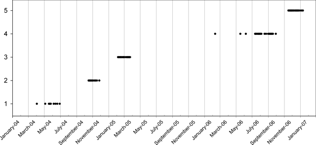 |
Figure 6. Plot showing days with MODIS thermal anomalies during January 2004-February 2007. Scale indicates the five arbitrary thermal anomaly periods, and does not reflect anomaly magnitudes. Eruptive activity was also reported on some occasions during gaps in thermal anomalies. Compiled from MODIS/HIGP data. |
Activity during April-November 2004. After a single thermal anomaly on 5 April 2004, another nine anomalies were seen in MODIS data during 5 May to 29 June. Observations provided by the CVGHM indicated continuing activity during this period. Reports from 31 May onward through 29 August noted that activity was centered at Crater I, but visual observations were often prevented by fog. On clear days white plumes rose 100-400 m above the crater rim. Incandescent glow seen at night reached 10-25 m above the summit. At Crater II, diffuse white plumes reached 25-50 m above the rim. During the three weeks of 9-29 August the reports also included observations of incandescent material and sounds of lava avalanches. Ten avalanche signals were recorded the week of 16-22 August. Shallow B-type volcanic earthquakes also increased significantly (table 12).
Table 12. Seismicity at Karangetang during 24 May-29 August 2004. Courtesy of CVGHM.
| Date | Deep volcanic (A-type) | Shallow volcanic (B-type) | Multiphase |
| 24 May-30 May 2004 | 4 | 12 | 5 |
| 31 May-06 Jun 2004 | 10 | 35 | 7 |
| 07 Jun-13 Jun 2004 | 22 | 22 | 4 |
| 14 Jun-20 Jun 2004 | 11 | 22 | 4 |
| 21 Jun-27 Jun 2004 | 45 | 49 | 13 |
| 28 Jun-04 Jul 2004 | 6 | 7 | 3 |
| 05 Jul-11 Jul 2004 | 16 | 30 | 1 |
| 12 Jul-18 Jul 2004 | 11 | 29 | 3 |
| 19 Jul-25 Jul 2004 | 11 | 18 | 16 |
| 26 Jul-01 Aug 2004 | 14 | 12 | 2 |
| 02 Aug-08 Aug 2004 | 12 | 75 | 11 |
| 09 Aug-15 Aug 2004 | 86 | 259 | 60 |
| 16 Aug-22 Aug 2004 | 10 | 153 | 74 |
| 23 Aug-29 Aug 2004 | 9 | 56 | 68 |
Between 16 October and 26 November 2004, thermal anomalies were again frequent. On 25 October the hazard status was raised due to increasing volcanism over the previous two days. A larger area of incandescence was noted at the summit, and a lava flow descended 800 m. No other reports of observations were available between September and November 2004.
Activity during January-March 2005. Thermal anomalies reappeared in MODIS satellite data on 6 February 2005, and continued to be detected on an almost daily basis through 24 March. CVGHM reports noted lava avalanches starting on 3 January 2005, accompanied by booming noises. During 24-30 January white gas plumes were emitted 50 m above both craters, and a 10- m-high glare was observed at night inside the plume from Crater II. Lava avalanches since 26 January originated from the lava-flow front, moving 750-1,200 m towards the Beha Barat River, 750-2,200 m towards the Batu Awang River, and 1,750 m towards the Kahetang River.
Lava avalanches in the first half of February had run-out distances of 1,250 m down the Beha River drainage, 700 m down the Batu Awang, 1,750 m down the Kahetang, and 1,200 m down the Nanitu. Incandescent material during this period was ejected ~25 m into the air and fell back into the crater. On 16 February, a lava flow advanced 600 m from the crater towards the Nanitu River. A pyroclastic flow later that evening from the lava front traveled 3.4 km and reached the sea, ~4 km from the summit. Lava avalanches from flow-fronts continued into late February toward the Beha, Kahetang, Batu Awang, and Nanitu drainages to distances of 500-1,200 m. These avalanche events produced continuous booming sounds and also "glowing bursts" to heights of 10-25 m. Gas emitted from Crater I rose 50-200 m, and a glare could be seen inside the gas column to heights of 25-75 m. Crater II also produced gas emissions 50-150 m high.
No additional reports are available until a mid-April 2005 report indicated that the volcano was still at a Level III hazard status. During clear weather over 2-9 May, a 400-m-high white gas plume rose from Crater I; there was a 25-m-high glare inside it. Meanwhile, Crater II emitted a white gas plume as high as 100 m. Due to the continuing possibility of pyroclastic avalanches and lahars during the rainy season, residents were not allowed within 2 km of the edge of the lava flow. On 30 May, based on a pilot observation, the Darwin VAAC reported ash at a height below 3 km drifting E; however ash was not visible on satellite imagery.
Activity during August-December 2005. The Darwin VAAC again issued an ash advisory on 2 August regarding a plume to an altitude of 4.6 km. This ash cloud, which continued through 4 August without significant interruptions, was occasionally discernable on both MTSAT and NOAA -12 satellites. Between 26 September and 16 October CVGHM reports again noted white gas rising 200-250 m from Crater I with a 25-m-high glare at the bottom of the gas column, and a 150-m gas emissions from Batukole crater. Tremor continued during 30 November-13 December 2005, but no other activity was described. Karangetang remained at Alert Level 3.
Activity during July-September 2006. Single MODIS thermal anomalies were seen on 11 February 2006, 18 May, and 8 June. Hot spots were then seen almost daily during 13 July-30 September. The Darwin VAAC noted a small eruption on 3 July 2006 with an ash plume to an altitude of 3.7 km observed on satellite imagery. On 12 July, lava flows were moving E toward the Kahetang and Batu Awang rivers, reaching a maximum distance of 2 km. White emissions rose 600 m above the crater. Having previously been lowered, the hazard status was raised from 2 to 3 on 13 July, and then to Alert Level 4 on 22 July due to increased eruptive activity. Lava flows 1.8 km from the vent were observed on 20 July moving E toward the Kahetang and Batu Awang rivers, were 2 km long towards the Keting River, and 400 m S towards the Bahembang River.
On 21 July, a pyroclastic flow from the upper S flank traveled 2.5 km toward the Batu Awang River and was followed by lava flows that traveled toward the Keting and E towards the Kahetang rivers, reaching a maximum runout distance of 2 km. On 22 July, Electronic Distance Measurement equipment indicated deformation measurements indicative of a bulge of about 3-5 mm. Diffuse white smoke was seen at a height of ~350 m above the summit. Lava flows traveled a maximum distance of ~2.3 km towards the Keting and S towards the Bahembang rivers during 22-23 and 25 July.
On 1 and 2 August 2006, lava flows traveled up to 500 m E toward the Batu Awang river and 300-750 m S towards the Keting River and white plumes reached heights of 50-300 m above the summit. Incandescent rockfalls originating from the summit and termini of the lava flows traveled 500-1,500 m E toward the Kahetang and Batu Awang rivers, S towards the Keting River, and occasionally 500 m S towards the Batang River. During 3-4 August, lava flows traveled up to 500 m E toward the Batu Awang river and 100-750 m S towards the Keting. During 7-13 August, lava flows again advanced E toward the Batu Awang river. Incandescent rockfalls originating from ends of the lava flows were also observed.
Activity from mid-August through September 2006 was relatively uneventful. The Darwin VAAC reported an ash cloud on 11 September. On 24 November the Darwin VAAC, reported an eruption that produced a small ash plume observed on satellite imagery that reached an altitude of 3 km.
Activity during November 2006-April 2007. After about six weeks without being detected, thermal anomalies were again frequently seen from 17 November through 11 January 2007. On 14 February the Alert Level was reduced from 3 to 2. Tremor events were recorded at a rate of 52/day over the previous two months, but had not increased since the 21 July 2006 pyroclastic flows, and earthquakes were shallow. Crater I continued to emit a thin trace of white gas 100-300 m above the crater rim. Emissions from Crater II rose to 50-250 m, with occasional incandescence up to 50 m.
Karangetang was relatively quiet until 28 March when a gas cloud was observed up to 100 m above the crater rim. According to a news article in the Jakarta Post, increased activity starting on 26 March led to the emission of "hot clouds" over the next two days. Based on satellite imagery and analysis from the US Geological Survey, the CVGHM reported that sometime between mid-March and 6 April the lava dome in the northern crater had collapsed and was replaced by a new dome ~40 m in diameter. A MODIS thermal anomaly was detected on 3 April. During 23-29 April only dense white plumes were observed from Crater II.
Information Contacts: Center of Volcanology and Geological Hazard Mitigation (CVGHM), Jalan Diponegoro 57, Bandung 40122, Indonesia (URL: http://vsi.esdm.go.id/); Hawai'i Institute of Geophysics and Planetology (HIGP) Hot Spots System, University of Hawai'i, 2525 Correa Road, Honolulu, HI 96822, USA (URL: http://modis.higp.hawaii.edu/); Darwin Volcanic Ash Advisory Centre (VAAC), Bureau of Meteorology, Northern Territory Regional Office, PO Box 40050, Casuarina, Northern Territory 0811, Australia (URL: http://www.bom.gov.au/info/vaac/); Jakarta Post, Indonesia (URL: http://www.thejakartapost.com/).
Eruptions during mid-2007; evacuations; pyroclastic flows; lava avalanches
The previous Bulletin report (BGVN 32:05) discussed periodic activity at Karangetang from January 2004 through April 2007. This report updates activity through August 2007. The island (Ulau Siau, or Siau) has a tear-drop-shape, widest at the N end with the tail bent E. The island's maximum E-W extent is about 10 km.
During April through mid August 2007, the Center of Volcanology and Geological Hazard Mitigation (CVGHM) recorded mild activity with periodic tremor activity registering at 0.5-2 mm and "thick-white-ash" periodically being ejected 25-750 m above the Main crater.
On 25 June 2007, an incandescent explosion 750 m high was observed and a lava avalanche traveled 1,000 m down the to Nawitu river and 400 m down the Bahambang river. Some materials descended into the Batuawang Valley.
Beginning 5 August 2007, the CVGHM recorded tremors with amplitude 4 mm in the vicinity of Karangetang. On 8 August, tremor amplitude increased to 23 mm and a lava fountain rose up to 25-75 m above the summit. Additional lava and pyroclastic flows observed on 10 August prompted authorities to evacuate more than 500 people from villages on the flanks.
On 11 August, because observers witnessed increased eruptive activity, and seismicity included tremors increasing to 46 mm in amplitude, the CVGHM raised the alert status from 2 to 3 (on a scale of 1-4). The alert status was again raised on 18 August from 3 to 4 as the CVGHM reported tremor (45-47 mm amplitude), lava emission, and a debris-flow about 2 km down the S flank. "Booming" noises were also heard and thick ashfall covered villages, farms, and trees on the flanks. Based on these advisories the Darwin Volcanic Ash Advisory Center notified aviation interests of the potential for a major eruption.
On 19 August, Karangetang erupted again several times. An avalanche of lava and hot ash poured down the flanks. Avalanches reportedly reached the coastal villages of Karalung (several kilometers SE of the summit) and Hiung (several kilometers NW of the summit). After 19 August eruptive activity decreased and on 30 August the hazard status was dropped to 3.
Thermal anomalies were detected by MODIS beginning 6-8 August with major activity occurring on 10 August and nearly continuous activity from 13 August through 2 September.
Information Contacts: Center of Volcanology and Geological Hazard Mitigation (CVGHM), Saut Simatupang, 57, Bandung 40122, Indonesia (URL: http://vsi.esdm.go.id/); Hawai'i Institute of Geophysics and Planetology (HIGP) Hot Spots System, University of Hawai'i, 2525 Correa Road, Honolulu, HI 96822, USA (URL: http://modis.higp.hawaii.edu/); Darwin Volcanic Ash Advisory Centre (VAAC), Bureau of Meteorology, Northern Territory Regional Office, PO Box 40050, Casuarina, Northern Territory 0811, Australia (URL: http://www.bom.gov.au/info/vaac/); Jakarta Post, Indonesia (URL: http://www.thejakartapost.com/).
A 2007 plume rose to 12.2 km altitude; incandescent rockfalls
The August 2007 eruptive activity reported in BGVN 32:08 subsided at the beginning of September 2007. Accordingly, the Center of Volcanology and Geological Hazard Mitigation (CVGHM) lowered the hazard alert status from 4 to 3 (on a scale of 1-4). The next notable observation was a report from the Darwin Volcanic Ash Advisory Center (VAAC) of a possible eruption on 4 October 2007 based on satellite imagery of a plume that rose to 12.2 km altitude.
On 13 and 21 October 2007, the Darwin VAAC reported that pilots had observed ash plumes at altitudes near that of the summit. Minor tremor was recorded on 30 October, and the crater continued to emit diffuse white plumes up to 100 m above the crater. On 23 November CVGHM lowered the alert status from 3 to 2 due to a decrease in both seismicity and observed plume height and density.
A pilot observation of a low-level ash plume on 12 March 2008 was reported by the Darwin VAAC. On 28 November 2008, CVGHM reported that increased seismicity indicated rockfalls, along with white plumes from summit craters I and II. On 29 November white and brownish plumes were emitted to low altitudes. Incandescent rockslides from the main crater traveled 250 m S towards the Bahembang River, 250 m W towards the Beha Timur River, and 500-1,000 m S towards the Keting River. Thunderous noises were reported.
Fog prevented visual observations on 30 November, but the seismic network recorded 160 rockfalls. On 1 December, incandescent rockslides traveled 250 m S towards the Bahembang River, 750 m W towards the Beha Timur River, and 500-1,500 m S towards the Keting River. On 2 December, the Alert Level was raised to 3 due to the continuation of elevated seismicity, the appreciable run-out distances of incandescent rockslides, and the height of incandescent material ejected from the summit.
Based on satellite imagery and CVGHM, the Darwin VAAC reported that on 2 December 2008 an ash plume rose to 3 km altitude and drifted W. MODVOLC thermal alerts were detected during 6 August-2 September 2007 and 2 December 2008-25 February 2009.
Information Contacts: Center of Volcanology and Geological Hazard Mitigation (CVGHM), Jalan Diponegoro 57, Bandung 40122, Indonesia (URL: http://vsi.esdm.go.id/); Hawai'i Institute of Geophysics and Planetology (HIGP) Thermal Alerts System, School of Ocean and Earth Science and Technology (SOEST), Univ. of Hawai'i, 2525 Correa Road, Honolulu, HI 96822, USA (URL: http://modis.higp.hawaii.edu/); Darwin Volcanic Ash Advisory Centre (VAAC), Bureau of Meteorology, Northern Territory Regional Office, PO Box 40050, Casuarina, NT 0811, Australia (URL: http://www.bom.gov.au/info/vaac/); Agence France-Presse (URL: http://www.afp.com/).
Elevated seismicity, lava flows in May 2009; high alert, evacuations
Lava flows from Karangetang (figure 7) reached several kilometers in length by the end of May 2009, and some residents evacuated. Witnessed plumes were minor, many below 100 m above the summit, the tallest 700 m above the summit. Intermittent minor activity, including explosions, ashfall, and thermal anomalies, has continued in the last few years (BGVN 32:05, 32:08, 34:01), with no significant changes since 2007 (figures 8 and 9).
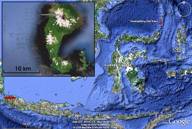 |
Figure 7. Map of the islands in the region around Karangetang, including Java, Bali, and Sulawesi (Celebes). Karangetang resides at upper right on Siau island, which is ~ 24-km-long, too small to see at this scale. (inset) An enlarged satellite image of Karangetang; white areas are clouds over volcanic peaks on the island. Maps have N directly upwards; scale bars are at lower left. Both maps courtesy of Google Earth. |
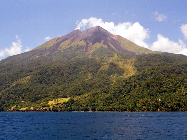 |
Figure 8. A 2007 photo of Karangetang taken from the sea (direction unspecified) showing multiple peaks and abundant unvegetated lava flows of young ages. The more distant cone may have been steaming. Photo by Mark Tolosa. |
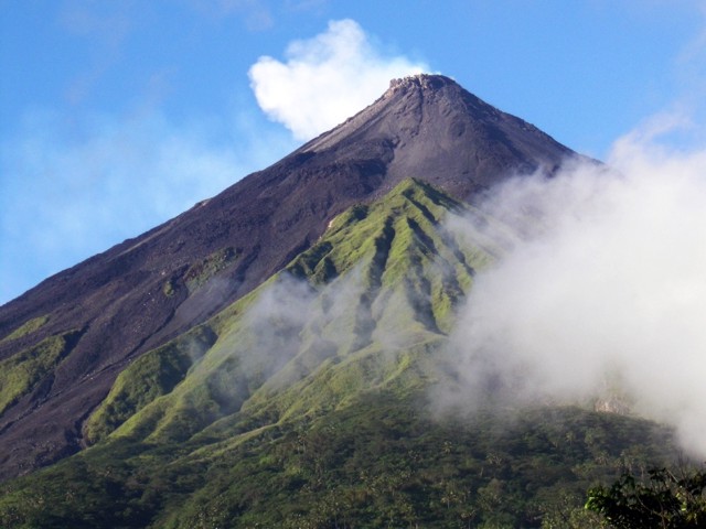 |
Figure 9. A photo of the summit area at Karangetang taken from the observatory station at Salili, S of the volcano, on 13 August 2007. Lava flows and rock avalanches during 2007 were not directly visible from this point. Note the rugged topography of the active lava dome at the summit. Courtesy of Arnold Binas. |
Based on a pilot observation, the Darwin VAAC reported that on 24 May an ash plume from Karangetang rose to an altitude of 3.7 km and drifted 75 km S. This was the tallest plume of the reporting interval.
On 31 May, based on seismicity, an increase in both volcanic tremor, and continuous air blasts (accompanied by rumbling sounds), the Center of Volcanology and Geological Hazard Mitigation (CVGHM) upgraded Karangetang's hazard status from Alert Level 3 (Siaga) to 4 (Awas) the highest level (figure 10). According to the website "Natural Disasters in Indonesia," hundreds of people were evacuated from near the volcano and the total number of vulnerable residents was 3,000. The Alert Level fell back to 3 on 9 June.
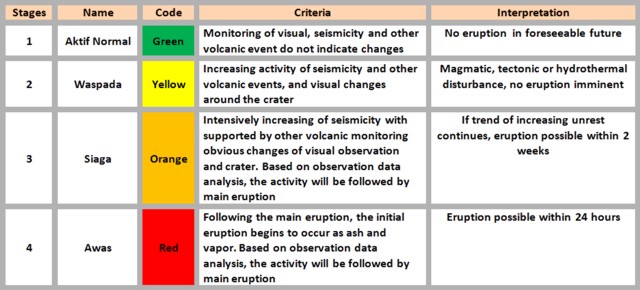 |
Figure 10. Alert levels applicable to Karangetang (and commonly used in Indonesia) with brief explanation of their significance. From the Natural Disasters in Indonesia website. |
Tremor was reported on 30 May and became continuous at times during the morning of 31 May (0600-1200). That same time interval saw the largest number of earthquakes. Craters I and II initially produced white plumes to heights of ~ 10-25 m and visible incandescence.
Beginning at 0630 a dense white to brownish plume from the principal crater reached a height of ~ 100 m above the peak. At 0824 there was a continuous expulsion of lava which flowed S, traveling ~ 2.3 km down the Kali Batuawang river. Lava also flowed ~ 1.5 km into the Kali Kahetang and Kali Keting rivers. Lava flows periodically traveled ~ 1 km down the Kali Nanitu and Batang rivers. At 0828 a thick grayish to plume was continuously ejected to a height of ~ 25-700 m accompanied by a rumbling sound of low to medium intensity.
In connection with the upgrading of the hazard status to Alert Level 4, CVGHM stepped up its monitoring and sent a team to the field. The regional government was alerted to the possible fallout of hot ash and the expulsion of lava flows. Numerous threatened towns and sub-districts were mentioned. These included Siau Timur, Kampung Kola-Kola (Bebali village); Kampung Bolo and Kampung Kopi, (Tarorane village); Kampung Hekang, Tatahadeng village, the village of Dame 1, the village of Karalung along the Kali Beha Timur river and, Kampung Dompase, along the banks of the Kali Nanitu and Kali Kinali rivers. There was the constant threat of lahar (mud flows) along the length of the rivers that originate from the active crater, including the Batu Awang, Kahetang, Keting, Batang, Beha Timur, and Nanitu rivers.
People were cautioned not to approach Karangetang closer than 3 km from the summit, particularly under conditions of heavy rain. Residents of the village of Dame and part of the population of the township of Tatahadeng were advised to maintain a high level of alertness to the dangers of pyroclastic flows and lava flows. In the case of sudden tephra falls, authorities recommended the public don face masks. As previously mentioned, on 9 June 2009 the alert level was reduce from 4 to 3.
MODVOLC. There were numerous MODVOLC thermal alerts during 2 December 2008-25 February 2009 (BGVN 34:01). As of late June 2009, dates of subsequent MODVOLC alerts for Karangetang were 18 and 29 March; 25, 26, 28, and 30 April; and 7, 14, and 31 May; and 3 June. In effect, the alerts were broadly spread for more than a year and showed little if any response to the elevated activity seen during the crisis.
Information Contacts: Center of Volcanology and Geological Hazard Mitigation (CVGHM), Jalan Diponegoro 57, Bandung 40122, Indonesia (URL: http://vsi.esdm.go.id/); Hawai'i Institute of Geophysics and Planetology (HIGP) Thermal Alerts System, School of Ocean and Earth Science and Technology (SOEST), Univ. of Hawai'i, 2525 Correa Road, Honolulu, HI 96822, USA (URL: http://modis.higp.hawaii.edu/); Darwin Volcanic Ash Advisory Centre (VAAC), Bureau of Meteorology, Northern Territory Regional Office, PO Box 40050, Casuarina, NT 0811, Australia (URL: http://www.bom.gov.au/info/vaac/); Agence France-Presse (URL: http://www.afp.com/); Arnold Binas, Toronto, Canada (URL: http://www.summitpost.org/user_page.php?user_id=42443, http://www.flickr.com/photos/hshdude/collections/72157600584144439/).
Lava flows and pyroclastic flows seen during 2009
At Karangetang during May 2009, emissions included explosions and lava flows (BGVN 34:05). Activity continued during June and into at least early 2010.
During the first week of June 2009, lava flows from Karangetang traveled 50 m E and 600 m SE. According to the Center of Volcanology and Geological Hazard Mitigation (CVGHM), incandescent rocks from the main craters and ends of the lava flow traveled as far as 2 km towards multiple river valleys, including the Keting River to the S. On 1 June, white-to-gray-to-brown plumes rose 700 m above the main crater. Incandescent lava was ejected 500-700 m. On 4 June, both the tremor amplitude and the number of earthquakes decreased. During 4-6 June, white plumes rose 50-300 m from the main crater. On 7 and 8 June, fog often prevented observations and incandescent rocks were rarely seen. The Alert Level was lowered to 3 (on a scale of 1-4) on 9 June.
No further activity was reported until 3 November 2009. Based on a pilot observation and satellite imagery, the Darwin Volcanic Ash Advisory Centre (VAAC) reported that on 3 November an ash plume rose to an altitude of 3 km and drifted 90-185 km W.
According to news reports, a pyroclastic flow and a lahar descended the flanks on 4 November. Residents saw active lava flows the next day. On 11 November, incandescent material was ejected 5 m into the air.
CVGHM noted that seismicity declined during 1 January-8 February 2010. When the weather was clear, white plumes were seen rising 100-200 m above the crater rim. Incandescent material was ejected 10-50 m above the Utama Crater. CVGHM lowered the Alert Level to 2 on 12 February.
MODVOLC. MODVOLC thermal alerts that were previously reported in March through 3 June 2009 (BGVN 34:05) continued through 8 November. Alerts were recorded on 10 July, 5 September, 5 October, 16 October, 30 October, 3 November (4 pixels on Aqua, 4 pixels on Terra), 4 November (2 pixels on Terra, 1 pixel on Aqua), and 8 November. No alerts were recorded between 8 November 2009 and 19 February 2010.
Information Contacts: Center of Volcanology and Geological Hazard Mitigation (CVGHM), Jalan Diponegoro 57, Bandung 40122, Indonesia (URL: http://vsi.esdm.go.id/); Hawai'i Institute of Geophysics and Planetology (HIGP) Thermal Alerts System, School of Ocean and Earth Science and Technology (SOEST), Univ. of Hawai'i, 2525 Correa Road, Honolulu, HI 96822, USA (URL: http://modis.higp.hawaii.edu/); Darwin Volcanic Ash Advisory Centre (VAAC), Bureau of Meteorology, Northern Territory Regional Office, PO Box 40050, Casuarina, NT 0811, Australia (URL: http://www.bom.gov.au/info/vaac/); Berita News (URL: http://berita.liputan6.com/).
Eruption in August 2010 isolated 20,000 residents and caused four deaths
A sudden eruption at Karangetang on 6 August 2010 occurred without warning and caused considerable damage. This report covers the interval from 6 August 2010 to mid-March 2011. Previously, the Indonesian Center of Volcanology and Geological Hazard Mitigation (CVGHM) had reported that, after explosions and lava flows during May and June 2009 and a pyroclastic flow and lahar in November 2009, seismicity had declined through early February 2010 (BGVN 35:01). On 12 February 2010, CVGHM had lowered the Alert Level to 2 (on a scale of 1-4).
According to news articles, an explosion on 6 August 2010 ejected hot clouds of gas and sent pyroclastic flows down the W flank. At least one house was buried and several other buildings, including a church, were damaged. A damaged bridge isolated about six villages and their ~20,000 residents, and communication links were lost. According to news reports (CNN and Associated Press), four people were confirmed dead and five were injured, and about 65 were evacuated. The Darwin Volcanic Ash Advisory Centre (VAAC) reported that an ash plume rose to an altitude of 9.1 km and drifted W on that same day.
The news reports cited CVGHM official Priyadi Kardono as noting that the volcano erupted just after midnight when water from heavy rains had penetrated the volcano's hot lava dome, causing the explosion. According to these reports, Kardono said volcanologists did not issue a warning about the eruption because there were no indications of increased volcanic activity. Kardono also noted that the explosion was not large, and the flow of volcanic debris had since decreased.
CVGHM reported that during 1-21 September 2010, lava traveled 75-500 m down Karangetang's flanks and avalanches traveled as far as 2 km down multiple drainages, to the S, E, and W. Incandescent material was ejected up to 500 m above the crater. Ashfall was reported in areas to the NW.
On 21 and 22 September incandescent material traveled down multiple drainages. Strombolian activity was observed on 22 September; material ejected 50 m high fell back down around the crater. That same day, the Alert level was raised to 3.
During November and early December 2010, CVGHM noted a drastic decrease in the occurrence of pyroclastic flows on Karangetang's flanks. Seismicity also decreased. The only reports were of white plumes that rose up to 300 m above the craters. The Alert Level was thus lowered to 2 on 13 December 2010.
According to CVGHM, the Alert Level was again raised from 2 to 3 on 11 March 2011 due to increased seismicity. According to news reports, lava flows were visible and blocks originating from the lava dome traveled as far as 2 km down the flanks, along with hot gas clouds. A Reuters News photo published in Okezone News showed a moderate Strombolian eruption venting from the summit on 11 March, with an apron of incandescent spatter dotting the upper slopes, and a swath of red spatter and bombs bouncing down one flank. Darwin VAAC reported that on that same day, an ash plume rose to an altitude of 2.4 km and drifted 55 km SW; on 13 March, another ash plume rose to an altitude of 3.7 km and drifted 37 km.
During 12-16 March, CVGHM stated that bluish gas plumes rose 50-150 m above the main crater. On 17 March lava flows traveled as far as 2 km from the main crater, accompanied by roaring and booming noises.
On 18 and 20 March lava flows traveled 1.5-1.8 km and collapses from the lava flow fronts generated avalanches that moved another 500 m. Avalanches from the crater traveled 3.8 km down the flanks. Multiple pyroclastic flows about 1.5-2.3 km long destroyed a bridge, damaged a house, and trapped 31 people (later rescued) between the flow paths. Later that day, pyroclastic flows traveled 4 km, reaching the shore. The Alert Level was raised to 4. According to news articles, 600-1,200 people were evacuated from villages on the W flank.
During the week after 20 March, seismicity and deformation declined. The number of new lava flows also declined.
MODVOLC Thermal Alerts. Thermal alerts derived from the Hawai'i Institute of Geophysics and Planetology Thermal Alerts System (MODVOLC) were reported through 19 February 2010 in BGVN 35:01. A significant number of alerts were measured on 19 March 2010 (14 pixels at 0215 UCT on Terra) and 23 March (1 pixel on Aqua), followed by ~5 months without measured alerts. Alerts reappeared during 16 August-19 October 2010. Alerts were absent between 20 October 2010 and 10 March 2011, followed by renewed alerts during 11-12 March 2011.
Information Contacts: Center of Volcanology and Geological Hazard Mitigation (CVGHM), Jalan Diponegoro 57, Bandung 40122, Indonesia (URL: http://vsi.esdm.go.id/); Darwin Volcanic Ash Advisory Centre (VAAC), Bureau of Meteorology, Northern Territory Regional Office, PO Box 40050, Casuarina, NT 0811, Australia (URL: http://www.bom.gov.au/info/vaac/); Hawai'i Institute of Geophysics and Planetology (HIGP) MODVOLC Thermal Alerts System, School of Ocean and Earth Science and Technology (SOEST), Univ. of Hawai'i, 2525 Correa Road, Honolulu, HI 96822, USA (URL: http://modis.higp.hawaii.edu/); Okezone News (URL: http://news.okezone.com/read/2011/03/12/340/434280/gunung-muntahkan-lava-pijar); Associated Press (URL: http://www.ap.org/); Reuters (URL: http://www.reuters.com/); CNN (URL: http://www.cnn.com/); Straits Times (URL: http://www.straitstimes.com/); Novinite (URL: http://www.novinite.com/).
2011 into 2014: Spatter at crater, lava flows, and ash plumes
Our last Bulletin report (BGVN 36:01), covered the interval from 6 August 2010 to late-March 2011. This report covers activity for 21 March 2011 through 9 February 2014. During this interval, eruptions clearly took place in March and April 2011, in May 2012, and in April 2013. Crater glow was seen in July, and again during late August to early September 2013, suggesting eruptions. The next report came 9 February 2014, again indicating an eruption then. MODVOLC data discussed at the end also supplements this eruptive information. Highlights include several episodes of abundant alerts and several intervals with pauses, including a 10 month pause that ended on 17 May 2012.
2011. The Center of Volcanology and Geological Hazard Mitigation (CVGHM) reported that during 21-23 March incandescent material from Karangetang was ejected 50-75 m above the crater. Lava flows traveled as far as 2 km and collapses from the lava-flow fronts generated avalanches that moved down the flanks at most another 300 m. On 24 March lava was incandescent in areas 1.5 km away from the crater. Incandescent material from the lava-flow fronts rolled an additional 200-500 m down the flanks. Incandescent material was again ejected 75 m above the crater. Later that day, due to decreased seismicity and a decline in the rate of lava flows, the Alert Level was lowered to 3 (on a scale of 1-4).
CVGHM reported that during 30-31 March incandescence emanated from Karangetang's main crater as well as bluish and white gas plumes. Lava flows originating from the main crater traveled 2 km down the flanks. Incandescent avalanches from the main crater and from the lava-flow fronts traveled up to 1.8 km down the flanks. On 31 March a thunderous sound was accompanied by a gray plume that rose 200 m above the crater. The Alert Level remained at 3 (on a scale of 1-4). During 1 May and at least into August, lava flows remained active. News indicated 600 people evacuated in August.
2012. Based on analyses of satellite imagery, the Darwin Volcanic Ash Advisory Centre (VAAC) reported that on 14 May 2012 an ash plume rose to 3.7 km a.s.l. and drifted 130 km SE. On 16 May an ash plume again rose to an altitude of 3.7 km a.s.l. then drifted about 110 km SE. The VAAC also described a 16 December ash plume to an altitude of 3.7 km drifting 110 km SE.
2013. Based on analyses of satellite imagery and wind data, the Darwin VAAC reported that on 9 April an ash plume rose to an altitude of 4.3 km a.s.l. and drifted over 45 km WNW. According to a (Kompas) news article, pahoehoe lava flows traveled 150 m and rock avalanches traveled 2 km on that same day.
Based on reports from the observation post in Salili, CVGHM stated on 26 July that the occurrence of rock avalanches descending Karangetang's flanks decreased during 2013; the last one occurred on 7 July, and traveled 2 km down the Batuawang and Kahetang (E) drainages. Although fog often prevented visual observations, white plumes were sometimes seen rising up to 500 m from two craters. Incandescence from the lava dome was reflected in the plume at night. Seismicity fluctuated, but signals indicating avalanches declined. Based on the cessation of avalanches, visual observations, and decreasing seismicity, the Alert Level was lowered to 2 (on a scale of 1-4) on 26 July.
Based on observations from the post in Salili, CVGHM reported that although Karangetang was sometimes covered in fog during 1 August-2 September white plumes were seen rising up to 500 m above the main crater and up to 300 m above Crater II. Incandescence from the crater was often observed at night. Avalanches began traveling down the Batuawang drainage on 2 September and then intensified the next day. The Alert Level was raised to 3 (on a scale of 1-4) on 3 September.
2014. Based on analyses of satellite imagery and wind data, the Darwin VAAC reported that on 9 February an ash plume rose to an altitude of 4.3 km a.s.l. and drifted over 80 km W.
MODVOLC thermal alerts. In BGVN 36:01 we reported thermal alerts derived from the Hawai'i Institute of Geophysics and Planetology Thermal Alerts System (MODVOLC), discussing the presence or absence of thermal alerts through the last available posted alert, 12 March 2011. During this report's duration, the alerts sometimes continued and were typically abundant, usually on the order of one or more per week or two, but in some cases several alerts per day, until pausing after 15 May 2011. They resumed during the days 8 and 13 August 2011 and then stopped.
When the alerts resumed on 17 May 2012, they had undergone a pause of 10 months. Alerts were again abundant during 17 May until 18 June 2012. A pause ensued until 9 September 2012 and the alerts were common until 26 January 2013. The subsequent pause ended and alerts resumed during 4 April-5 June 2013. The subsequent pause took place during 6 June-2 September 2013, and then the pause ended with a few alerts during 3-5 September 2013 but an absence of alerts for the remainder of 2013. When checked on 1 July 2014, only one alert for 2014 had been posted: 8 June 2014.
Information Contacts: Center of Volcanology and Geological Hazard Mitigation (CVGHM), Jalan Diponegoro 57, Bandung 40122, Indonesia (URL: http://vsi.esdm.go.id/); Darwin Volcanic Ash Advisory Centre (VAAC), Bureau of Meteorology, Northern Territory Regional Office, PO Box 40050, Casuarina, NT 0811, Australia (URL: http://www.bom.gov.au/info/vaac/); Kompas (URL: http://nasional.kompas.com/read/2013/04/09/08311241/Guguran.Lava.Karangetang.Hingga.2.km); Hawai'i Institute of Geophysics and Planetology (HIGP) MODVOLC Thermal Alerts System, School of Ocean and Earth Science and Technology (SOEST), Univ. of Hawai'i, 2525 Correa Road, Honolulu, HI 96822, USA (URL: http://modis.higp.hawaii.edu/).
Intermittent ash plumes, lava flows, pyroclastic flows, and lahars; persistent thermal anomalies, June 2014-December 2016
The Karangetang andesitic-basaltic stratovolcano (also referred to as Api Siau) at the northern end of the island of Siau, north of Sulawesi, Indonesia has had more than 50 historically-observed eruptions since 1675. Frequent explosive activity is accompanied by pyroclastic flows and lahars, and lava-dome growth has created multiple summit craters. Rock avalanches, observed incandescence, and satellite thermal anomalies at the summit confirmed continuing volcanic activity through 5 September 2013 (BGVN 39:01). Activity is monitored by Indonesia's Pusat Vulkanologi dan Mitigasi Bencana Geologi (PVMBG, also known as CVGHM, or the Center of Volcanology and Geological Hazard Mitigation), and ash plumes are monitored by the Darwin VAAC (Volcanic Ash Advisory Center). Information is also available from MODIS thermal anomaly satellite data through both the University of Hawaii's MODVOLC system and the Italian MIROVA project.
An ash plume reported by the Darwin VAAC on 9 February 2014 that rose to an altitude of 4.3 km (2.5 km above the summit) and drifted over 80 km W was the only recorded activity at Karangetang between MODVOLC thermal anomalies on 5 September 2013 and on 8 June 2014. Additional thermal anomalies identified between June and September 2014, and increased seismicity reported by PVMBG in September, indicated ongoing activity. An ash plume was reported by the Darwin VAAC in October 2014. A spike in thermal activity was recognized during 12 January-1 February 2015. Another strong thermal signal began on 13 May that continued through 9 December 2015, when visual reports of lava flows and ash plumes were all recorded. Ash plumes were last reported by the Darwin VAAC in January 2016; night incandescence at the summit was reported by PVMBG until 15 March 2016. The Alert Level remained at 3 from September 2013 through 16 March 2016, when it was lowered to 2. Persistent low-energy thermal anomalies were captured by MIROVA throughout 2016, but there were no PVMBG observations indicating ongoing dome growth or other eruptive activity.
Activity during 2014. On 9 February 2014, the Darwin VAAC reported an ash plume rising to 4.3 km and extending over 80 km to the W based on satellite images. The next observation of activity was a single MODVOLC thermal alert pixel on 8 June 2014 located precisely over the summit. More substantial thermal anomalies appeared between 19 and 24 July, followed by two more on 2 August, after which there is a break of more than five months with no MODVOLC thermal anomalies. The MIROVA system, however, does record intermittent, low-level anomalies through early December 2014 (figure 11).
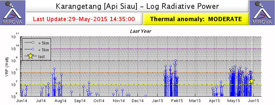 |
Figure 11. MIROVA Log Radiative Power Thermal Anomaly data for 29 May 2014 through 29 May 2015 at Karangetang. Activity increases during July 2014 and slowly tapers off into December before the sudden appearance of a moderate to high thermal anomaly was recorded between 12 January and 1 February 2015. Activity increases again in early April 2015. Image courtesy of MIROVA. |
On 15 September 2014, PVMBG issued a report noting that seismic amplitudes were relatively high at the volcano, increasing from much lower levels on 12 September. Seismic data also indicated an increase in earthquakes indicating avalanches in late July which corresponded in time with the thermal anomalies recorded by MODVOLC and MIROVA. PVMBG observed steam plumes rising to between 100 and 150 m above the main summit crater, and to around 25 m above the second crater during the second week of September 2014, along with incandescence at the summit. The last 2014 report of activity came from the Darwin VAAC; they reported an ash plume on 20 October rising to 3 km and drifting 75 km NW.
Activity during 2015. Both the MODVOLC and MIROVA systems report the abrupt appearance of strong thermal anomalies on 12 January 2015, continuing until 1 February when they stopped just as suddenly (figure 11). A news article by a local newspaper (Jaringan Berita Terluas di Indonesia) reported that a lahar on 22 January 2015, triggered by heavy rains, descended the volcano's flanks, overflowed the banks of the Batu River, and damaged a number of public and private buildings in the village of Bahu about 7.5 km S of the volcano, and in Bebali, 4.5 km S. It also damaged the main road between the communities of Ulu and Ondong but the debris was quickly cleared by authorities.
The MIROVA system recorded thermal anomalies beginning again at the very end of March 2015 (figure 11); MODVOLC noted a single thermal alert on 13 April, and then strong, multi-pixel anomalies nearly continuously from 24 April through 11 June 2015. During the second half of April, PVMBG staff at the Volcano Observation Post in the village of Salili, 4 km SW, noted white steam plumes ranging from 50 to 350 m above the main crater and 25 m above the second crater, and incandescence from the summit. Additionally, they observed bluish-white plumes on 16 and 17 April rising to 50-150 m. They also concluded that the amplitude of seismic activity had decreased since the end of February.
Lava flows were first observed on 22 April; incandescent avalanches from the fronts of 150-m-long lava flows traveled up to 2 km down Batuawang and Kahetang drainages (E) during 22-29 April. On 26 April pyroclastic flows traveled 2.2 km along the Kahetang drainage. On 28 April explosions produced plumes and ejected incandescent material 50 m high (figure 12). Seismicity also increased from the previous week. The MIROVA data indicated a sudden spike of high thermal activity beginning around 22 April and continuing past the end of May (figure 11).
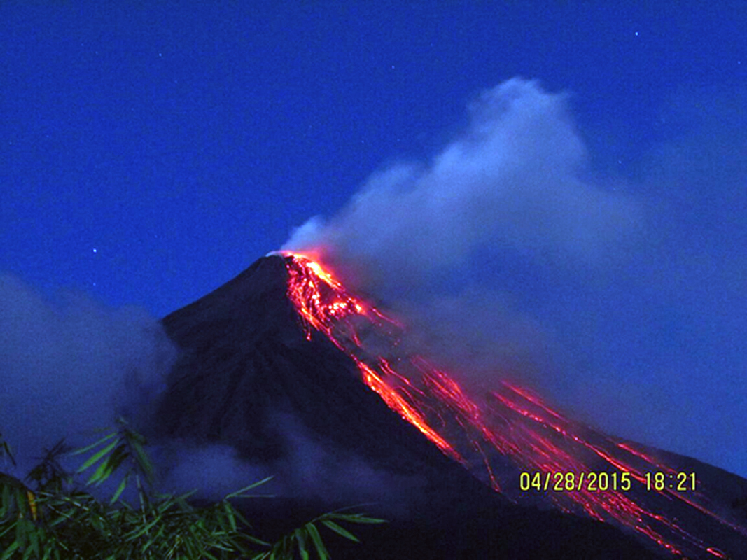 |
Figure 12. Incandescent lava flowing down Karangetang's flanks on 28 April 2015. Courtesy of PVMBG (G. Karangetang Activity Report, 29 April 2015). |
Activity at the volcano increased significantly at the beginning of May 2015. BNPB (Badan Nasional Penanggulangan Bencana) reported that on 7 May at 1400 an eruption that ejected incandescent material and produced a dense ash plume also generated a pyroclastic flow that traveled 4 km E, leveling four houses in Kora-Kora. The next day pyroclastic flows descended the S flank 2.5 km into the Kahetang (E) and Batuawang drainages. There were no reported fatalities; 465 people were evacuated from the village of Bebali, 4.5 km S. Also on 8 May, the Darwin VAAC reported an ash plume that rose to an altitude of 3 km drifted almost 85 km E, and dissipated two days later. On 12 May another ash plume rose to an altitude of 3.7 km and drifted 55 km SW, and there were reports by the Darwin VAAC via social media of continued pyroclastic flow activity. Steam plumes rising to 400 m continued into the last week of May, along with incandescence from the summit at night. The lava flows that first appeared on 22 April were 300 m long by the end of May and continued to send block avalanches from the fronts up to 2 km down the Batuawang, Kahetang, and Keting drainages to the SW, S and SE. Seismic amplitudes continued at a high level; seismicity was dominated by signals characteristic of avalanches, with harmonic tremor frequently detected.
On 5 June 2015 BNPB reported that activity remained high; a total of 339 people (106 families) from the villages of Ulu, Salili, Belali, and Tarorane, all a few kilometers S of the summit, remained displaced since early May. PVMBG reported that on 18 June a lahar descending Batuawang drainage (E) covered a 100-m section of roadway with 25 cm of mud containing 1-m-diameter boulders. The lahar also damaged or destroyed four homes. White plumes rising 150 m above the main crater and 25 m above crater II were observed from the Volcano Observation Post in Salili during late June. Incandescence from the lava dome was also observed at night. Lava flowed from the S part of the dome; incandescent avalanches from the front of the lava flow again traveled up to 2.3 km down the Batuawang and Kahetang drainages. Seismic activity continued to be high, although the number of daily earthquake indicating avalanches had dropped below 100 per day at the end of June. MODVOLC thermal anomaly pixels were recorded on 2-4, 9, and 11 June, far fewer than in May.
PVMBG reported that during the last two weeks of July 2015, white plumes rose 250 m above the main crater and 25 m above the second crater (crater II). Incandescence from the lava dome was observed at night when skies were clear, and incandescent avalanches from the fronts of new 150-m-long lava flows traveled up to 2.3 km E down the Batuawang, Kahetang and Keting drainages. Seismicity was dominated by signals characteristic of avalanches, with rare volcanic earthquakes. The Alert Level remained at 3. During the month, fewer MODVOLC thermal alerts were recorded than during May and June, only on 4, 6, 11, and 25 July.
Seismicity related to avalanche activity increased significantly on 14 August 2015 and the number of daily events spiked on 20 August to 599, marking a period of increased activity that continued into November (figure 13). Strong MODVOLC thermal alert signals reappeared on 10 August 2015 and continued with multiple-pixel signals almost daily until 1 October when they became more intermittent. The MIROVA thermal anomaly data also corroborated increased thermal activity during this period (figure 14).
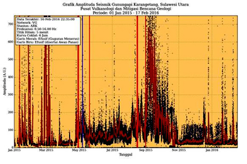 |
Figure 13. Seismic amplitude data (RSAM) from Karangetang, 1 January 2015 through 17 February 2016. Activity increased notably in the third week of August 2015 and remained elevated through the end of October, followed by intermittent pulses of activity through February 2016. Courtesy of PVMBG, (G. Karangetang Activity Report, 17 February 2015). |
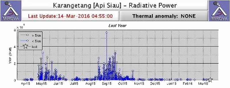 |
Figure 14. MIROVA thermal anomaly data for Karangetang from 14 March 2015 through 14 March 2016. The tapering of activity between May and July 2015 corresponds well with MODVOLC, seismic, and observational data for that period. Heightened activity between August and October 2015 also corresponds with increased seismic activity, abundant MODVOLC thermal anomaly pixels, visual observations of lava flows and ash plumes, and numerous VAAC reports during this time. Courtesy of MIROVA (published originally by PVMBG in G. Karangetang Activity Report, 16 March 2016). |
The Darwin VAAC reported that on 28 August 2015 a pyroclastic cloud was observed on satellite. The ash plume rose to an altitude of 2.4 km and drifted 55 km ENE. They also observed a number of ash plumes between 10 and 17 September that rose as high as 3 km and drifted up to 130 km generally E. Lava fountains as high as 300 m were observed from the Volcano Observation Post in Salili during 9-16 September. Debris fell as far as 300 m from the summit crater into the Kinali River. Incandescent avalanches from the fronts of 200-m-long lava flows traveled up to 2.5 km down the Batuawang, Kahetang, Keting, and Batang drainages; brownish smoke was observed at the end of the Batuawang flows. The Alert Level remained at 3.
During October 2015, MODVOLC thermal anomaly pixels became more intermittent, appearing on 10 days during the month, far fewer than September. Steam plumes from the main crater were observed from Salili up to 150 m above the crater along with incandescence on clear nights. Lava flows remained active 200 m from the crater still sending pyroclastic avalanches down the Batuawang, Kahetang, Keting, and Batang drainages up to 2 km from the lava fronts. The flows had increased to 600 m long between 19 and 22 October and the avalanches continued. Most seismicity decreased in early October, except harmonic tremor, suggesting that magma movement inside the volcano persisted. The Darwin VAAC reported that on 8 October an ash plume rose to an altitude of 2.7 km and drifted 65 km E and that during 18 October ash plumes rose to an altitude of 2.1 km and drifted 75-95 km NE. Constant harmonic tremors for 6 hours on 20 October indicated magma was still active.
Seismicity continued its steady decline since early September during November (figure 13), although tremor activity continued. Incandescence was still visible from the lava dome at night according to PVMBG, and the incandescent avalanches were still travelling up to 1.5 km down the Batuawang and Kahetang drainages. Steam plumes rose generally 50-200 m, and occasionally 400 m from the main crater. A lahar in Batuawang drainage flowed as far as the village of Bebali and covered about 50 m of the Ondong-Ulu highway on 20 November, similar to the event of 18 June. MODVOLC recorded only two thermal anomaly pixels at the summit, both on 25 November.
By December 2015, incandescence was still observed at the crater from the Volcano Observatory in Salili, but steam plumes rarely exceeded 150 m. A single MODVOLC thermal anomaly pixel, was recorded on 9 December, and spikes in seismic amplitudes were recorded on 21 and 22 December.
Activity during 2016. According to PVMBG, Karangetang was quiet during most of January 2016, although incandescence was reported from the main crater, and plumes of bluish and white smoke rose 50-100 m. There were no reports of active lava flows or incandescent avalanches, but the accumulation of material in the Batuawang drainage made the possibility of damaging lahars during the rainy season very high. The relatively constant number of shallow (VB) earthquakes suggested that the lava dome was growing slowly; there was a two-fold increase in RSAM values during the month (figure 13). Based on analyses of satellite imagery and wind data, the Darwin VAAC reported three ash plumes during the month; on 12 January an ash plume rose to an altitude of 5.2 km and drifted 65 km NW, on 14 January a steam-and-ash plume rose to an altitude of 5.2 km and drifted over 35 km W, and the next day an ash-and-steam plume rose to an altitude of 2.7 km and drifted about 20 km SW.
Incandescence continued at the summit during February and early March 2016 along with bluish-white plumes rising 25-100 m from the summit crater. Seismic energy values (RSAM) remained elevated during February, suggesting continued growth of the lava dome. The last MODIS thermal anomaly observed by PVMBG was on 8 March. Although they continued to observe incandescence 10-25 m above the summit and bluish-white emissions to 150 m through 15 March, they lowered the Alert Level from 3 to 2 on 16 March, noting that even though the RSAM seismic energy values were still above normal, they had been stable for some time. The MIROVA Thermal Anomaly Radiative Power data from March 2016 also showed a significant decline in thermal energy released from the volcano compared with the period from late April through November 2015 (figure 14). Although no further reports were issued by PVMBG or Darwin VAAC, the thermal anomalies detected by MIROVA continued at low to moderate levels during 2016, suggesting a persistent heat source at the volcano (figure 15).
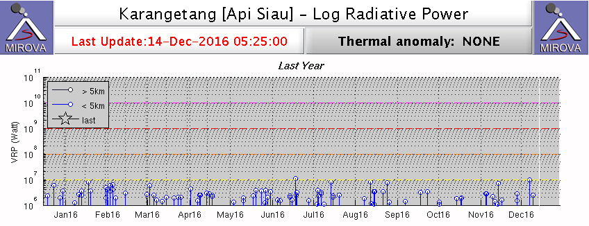 |
Figure 15. MIROVA Log Radiative Power Thermal Anomaly data for Karangetang from 14 Dec 2015 through 14 December 2016 showing continued low-energy thermal anomalies during the period. Courtesy of MIROVA. |
Information Contacts: Pusat Vulkanologi dan Mitigasi Bencana Geologi (PVMBG, also known as Indonesian Center for Volcanology and Geological Hazard Mitigation, CVGHM), Jalan Diponegoro 57, Bandung 40122, Indonesia (URL: http://www.vsi.esdm.go.id/); Badan Nasional Penanggulangan Bencana (BNPB), National Disaster Management Agency, Graha BNPB - Jl. Scout Kav.38 East Jakarta 13120 (URL: http://www.bnpb.go.id/); Darwin Volcanic Ash Advisory Centre (VAAC), Bureau of Meteorology, Northern Territory Regional Office, PO Box 40050, Casuarina, NT 0811, Australia (URL: http://www.bom.gov.au/info/vaac/); Hawai'i Institute of Geophysics and Planetology (HIGP), MODVOLC Thermal Alerts System, School of Ocean and Earth Science and Technology (SOEST), Univ. of Hawai'i, 2525 Correa Road, Honolulu, HI 96822, USA (URL: http://modis.higp.hawaii.edu/, http://modis.higp.hawaii.edu/cgi-bin/modisnew.cgi); MIROVA (Middle InfraRed Observation of Volcanic Activity), a collaborative project between the Universities of Turin and Florence (Italy) supported by the Centre for Volcanic Risk of the Italian Civil Protection Department (URL: http://www.mirovaweb.it/); Jaringan Berita Terluas di Indonesia, http://www.jpnn.com/read/2015/01/23/283204/Awas,-Lahar-Dingin-Karangetang-Kembali-Mengancam.
Small ash plume and incandescence seen on 2 February 2018
Eruptive activity at Karangetang between June 2014 and March 2016 included intermittent ash plumes, lava flows, pyroclastic flows, and persistent thermal anomalies from a slowly growing lava dome (BGVN 42:02) south of the highest summit (figure 16). Activity since mid-March 2016 has been low, with only a few notable events consisting of a possible ash plume on 10 May 2017, a strong sulfur dioxide emission on 10 October 2017, and a small ash explosion on 2 February 2018. Information was mainly provided by the Pusat Vulkanologi dan Mitigasi Bencana Geologi (PVMBG, also known as Indonesian Center for Volcanology and Geological Hazard Mitigation, CVGHM), the Darwin Volcanic Ash Advisory Centre (VAAC).
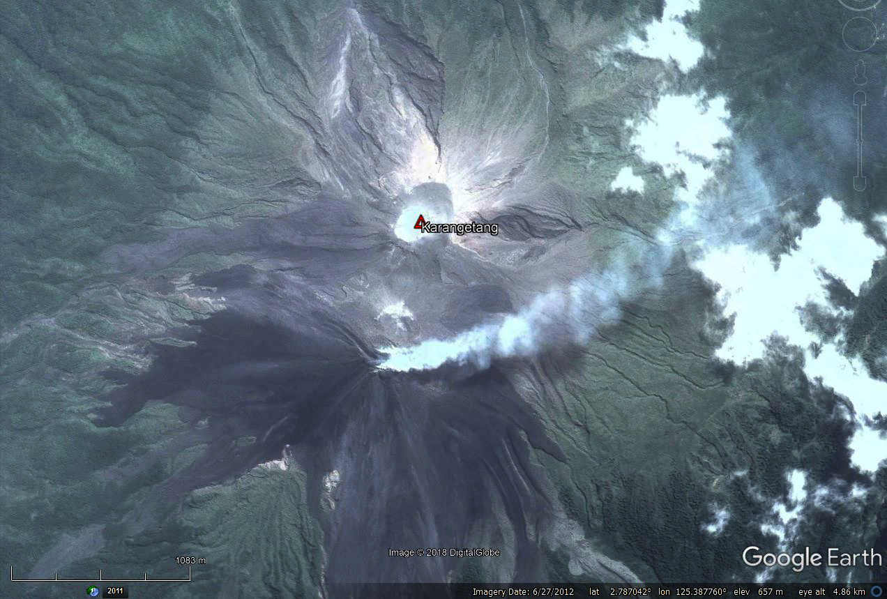 |
Figure 16. Satellite image of the summit area of Karangetang on 27 June 2012. The active dome is steaming, with the fumarolic plume curving towards the NE. Dark-colored recent lava flows are noticeable. The higher inactive summit is about 500 m N and 20 m higher than the active dome. Courtesy of DigitalGlobe and Google Earth. |
Based on analyses of satellite imagery, wind data, and ground-based visual observations, the Darwin VAAC reported that on 10 May 2017 a gas-and-steam plume apparently containing ash rose to an altitude of 3.6 km and drifted over 35 km SE. The Aviation Color Code was briefly raised to Orange.
According to a news account (Antara News) that quoted the chief of the volcano's observatory post, "sulfuric smoke" rose 200 m on 10 October 2017. The official stated that this was natural activity for the volcano and also indicated that several types of tremor had occurred the previous day. A small SO2 anomaly near the volcano was detected on 11 October 2017, registering 2.1 Dobson Units on the Aura satellite Ozone Monitoring Instrument.
In a Volcano Observatory Notice for Aviation (VONA) issued on 2 February 2018, PVMBG reported an explosion, crater incandescence, and an ash plume that rose 600 m above the summit. The Aviation Color Code was raised from Unassigned to Yellow.
No MODVOLC thermal anomalies were detected during the reporting period. The MIROVA system, however, detected twelve scattered low-power thermal anomalies in the year ending on 26 April 2018. One of the thermal anomalies occurred around 10 October.
Information Contacts: Pusat Vulkanologi dan Mitigasi Bencana Geologi (PVMBG, also known as Indonesian Center for Volcanology and Geological Hazard Mitigation, CVGHM), Jalan Diponegoro 57, Bandung 40122, Indonesia (URL: http://www.vsi.esdm.go.id/); Darwin Volcanic Ash Advisory Centre (VAAC), Bureau of Meteorology, Northern Territory Regional Office, PO Box 40050, Casuarina, NT 0811, Australia (URL: http://www.bom.gov.au/info/vaac/); Hawai'i Institute of Geophysics and Planetology (HIGP) - MODVOLC Thermal Alerts System, School of Ocean and Earth Science and Technology (SOEST), Univ. of Hawai'i, 2525 Correa Road, Honolulu, HI 96822, USA (URL: http://modis.higp.hawaii.edu/); MIROVA (Middle InfraRed Observation of Volcanic Activity), a collaborative project between the Universities of Turin and Florence (Italy) supported by the Centre for Volcanic Risk of the Italian Civil Protection Department (URL: http://www.mirovaweb.it/); NASA Goddard Space Flight Center (NASA/GSFC), Global Sulfur Dioxide Monitoring Page, Atmospheric Chemistry and Dynamics Laboratory, 8800 Greenbelt Road, Goddard, Maryland, USA (URL: https://so2.gsfc.nasa.gov/); Antara News (URL: https://en.antaranews.com/).
Activity at two craters with the N crater producing ash plumes, avalanches, pyroclastic flows, and lava flows that reached the ocean in February 2019
Karangetang (also referred to as Api Siau) is an active volcano on the island of Siau in the Sitaro Regency, North Sulawesi, Indonesia. It produces frequent small eruptions that include gas-and-steam plumes, ash plumes, avalanches, lava flows, incandescent ballistic ejecta, and pyroclastic flows. This report covers May 2018-April 2019 and summarizes reports by Indonesia's Pusat Vulkanologi dan Mitigasi Bencana Geologi (PVMBG, also known as CVGHM, or the Center of Volcanology and Geological Hazard Mitigation), and the Darwin VAAC (Volcanic Ash Advisory Center), and satellite data. During this time, increased activity resulted in a lava flow that reached the ocean and cut road access to communities.
No activity was reported during May through October 2018. During this time, Sentinel-2 thermal images showed elevated temperatures in the main active crater and gas-and-steam plumes dispersing in different directions (figure 17). On 4 July, the Darwin VAAC reported a "weak" ash plume to an altitude of 3 km that drifted NE, only based on satellite imagery. There were few thermal signatures detected by the MIROVA algorithm from May through November (figure 18).
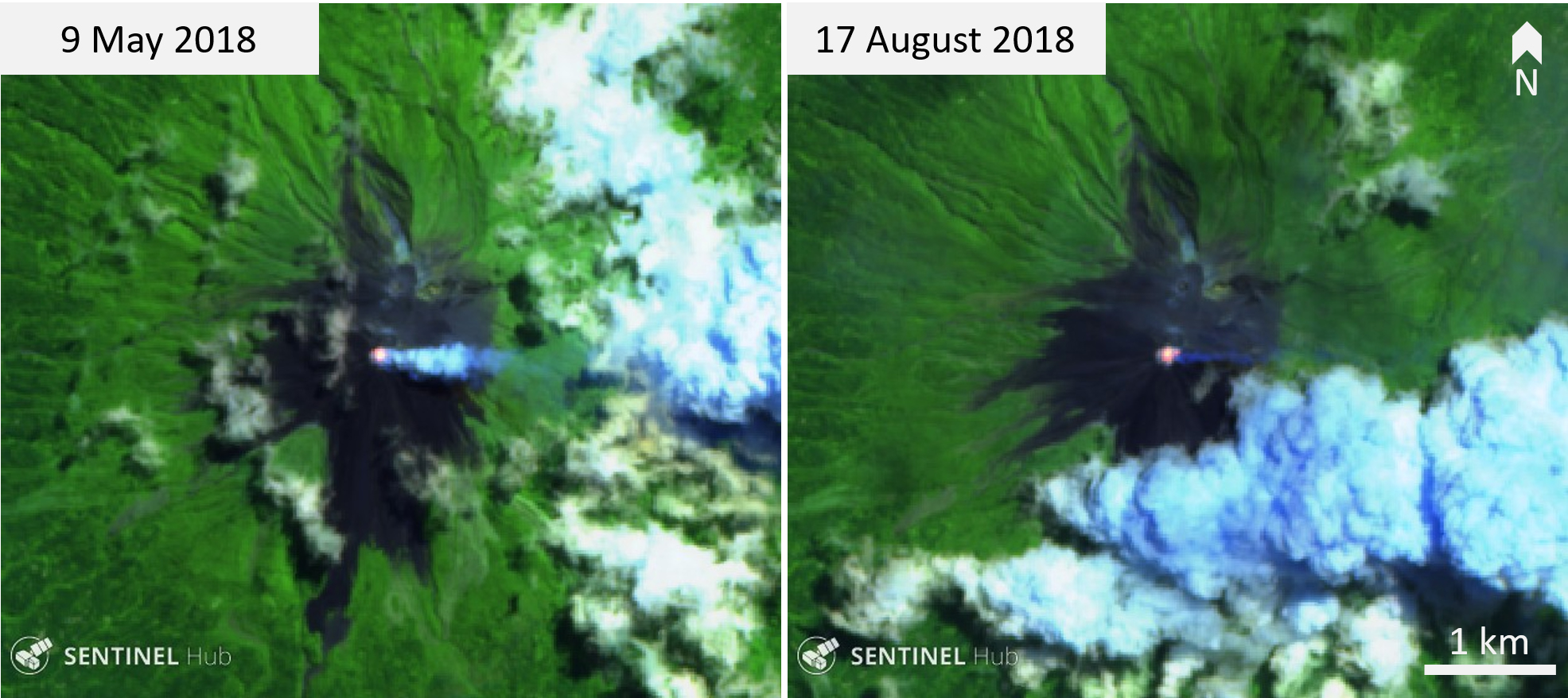 |
Figure 17. Incandescence and weak steam-and-gas plumes at the southern crater of Karangetang on 9 May and 17 August 2018. This was common in cloud-free images acquired during this time. Sentinel-2 false color (bands 12, 11, 4) images courtesy of Sentinel Hub Playground. |
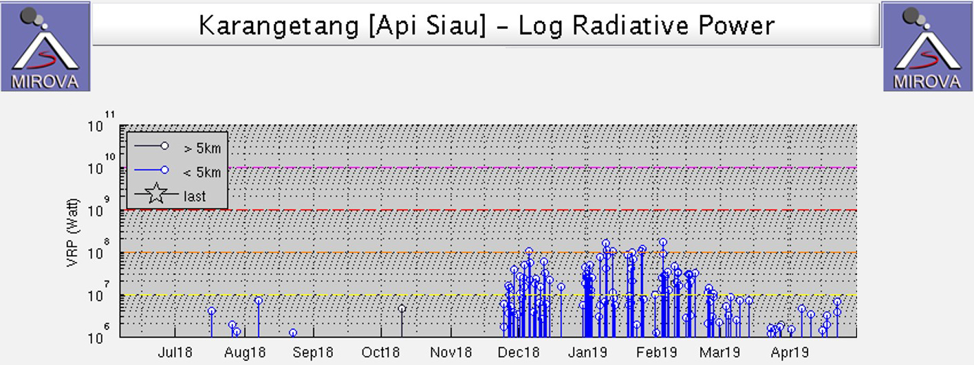 |
Figure 18. MIROVA log radiative power plot of MODIS infrared data for June 2018 through April 2019. There was little thermal energy detected before December, after which levels remained high until they began declining in March 2019. Courtesy of MIROVA. |
Steam plumes were observed from two craters during November 2018 (figures 19 and 20). There was a significant increase in seismicity on 22 to 23 November, followed by a sharp decline on the 24th. The first MODVOLC thermal alert was issued on 25 November. At 1314 on 25 November an ash plume rose to at least 500 m above the N crater and the Aviation Color Code was raised to Orange. A Sentinel-2 thermal image acquired on this day showed elevated temperatures at both south and north craters, with accompanying gas-and-steam plumes. After the increase in seismicity and detected thermal energy, activity progressed to lava flow extrusion, avalanches, and pyroclastic flows triggered from the lava flow. The lava flow originated from the north crater (Kawah Dua) and moved towards the NNW. Avalanches accompanied the flow from the crater and down the lava flow surface. The Volcano Alert level was increased from II to III on 20 December at 1800 (on a scale of I to IV).
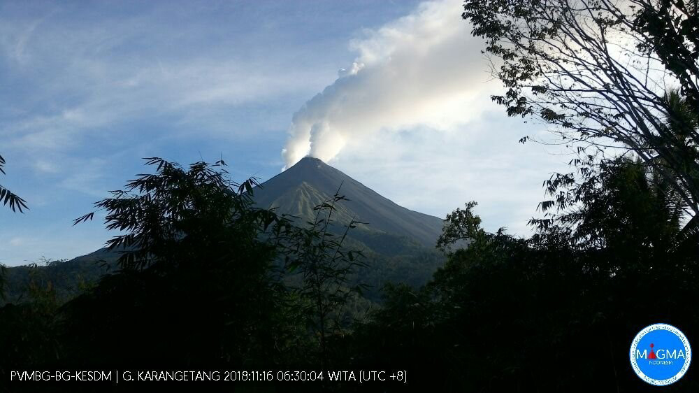 |
Figure 19. White gas-and-steam plumes emanating from two craters at Karangetang at 0630 on 16 November 2018. Courtesy of MAGMA Indonesia via Øystein Lund Andersen. |
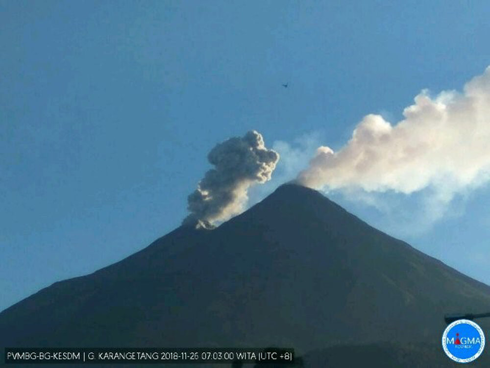 |
Figure 20. An ash plume from the N crater (left) and a gas-and-steam plume from the S crater (right) of Karangetang at 0703 on 26 November 2018. Courtesy of MAGMA Indonesia via Øystein Lund Andersen. |
Throughout January 2019 activity consisted of small ash plumes up to 600 m above the N crater (figure 21) and continued lava flow activity. On 17 January Kompas TV reported that heavy ashfall impacted several villages. Lava and avalanches traveled as far as 0.7-1 km W towards the Sumpihi River and 1-2 km NE down the Kali Batuare throughout the month.
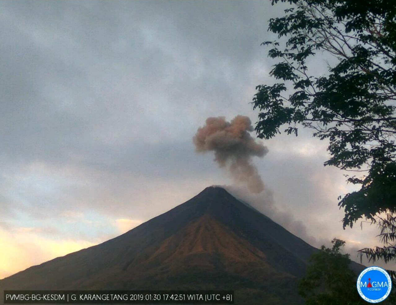 |
Figure 21. A small ash plume on 31 January 2019 at Karangetang. Courtesy of MAGMA Indonesia via Øystein Lund Andersen. |
Video taken on 3 February 2019 shows the lava flow covering the road and continuing down the steep slope with multi-meter-scale incandescent blocky lava fragments on the surface dislodging and triggering small avalanches. By 5 February the lava flow reached over 3.5 km down the Malebuhe River drainage on the NW flank and into the ocean where a lava delta was growing with dense steam plume rising above by the 11th (figures 22-26). Drone footage from 9 February shows the lava flow across the section of road had a width of about 160 m and a width of about 140 m at the coast. Gas-and-steam and ash plumes were noted most days, reaching up to 600 m above the crater and dominantly dispersing to the E (figure 27). By 11 February there had been 190 people evacuated.
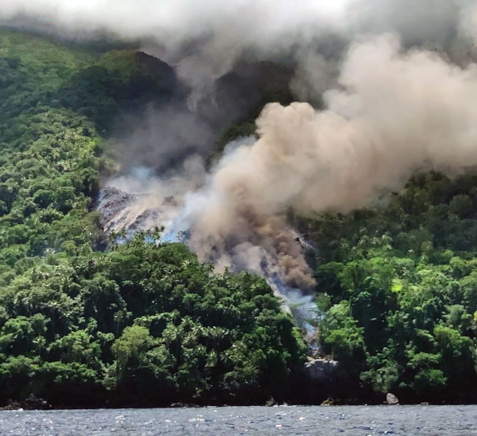 |
Figure 22. The lava flow front at Karangetang nearing the ocean on 5 February 2019. Courtesy of MAGMA Indonesia. |
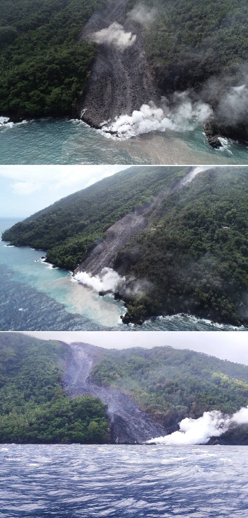 |
Figure 23. The lava flow entering the ocean at Karangetang in early February 2019. Photos posted on 11 February; courtesy of BNPB. |
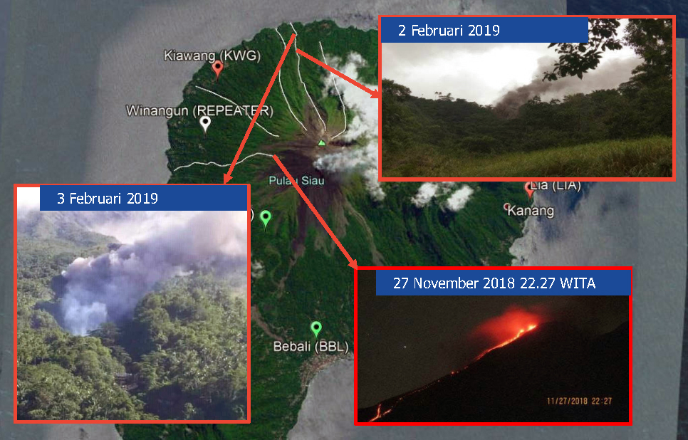 |
Figure 24. Locations of activity observations at Karangetang in November 2018 and February 2019. 27 November 2018: the descent of lava from the Kawah Dua crater (N crater) to about 700-1000 m away, towards the Sumpihi River and Kinali Village. 2 February 2019: the descent of lava 2.5 km NW, 500 m from the highway. 5 February 2019: the lava flow reached the sea. Courtesy of BNPB. |
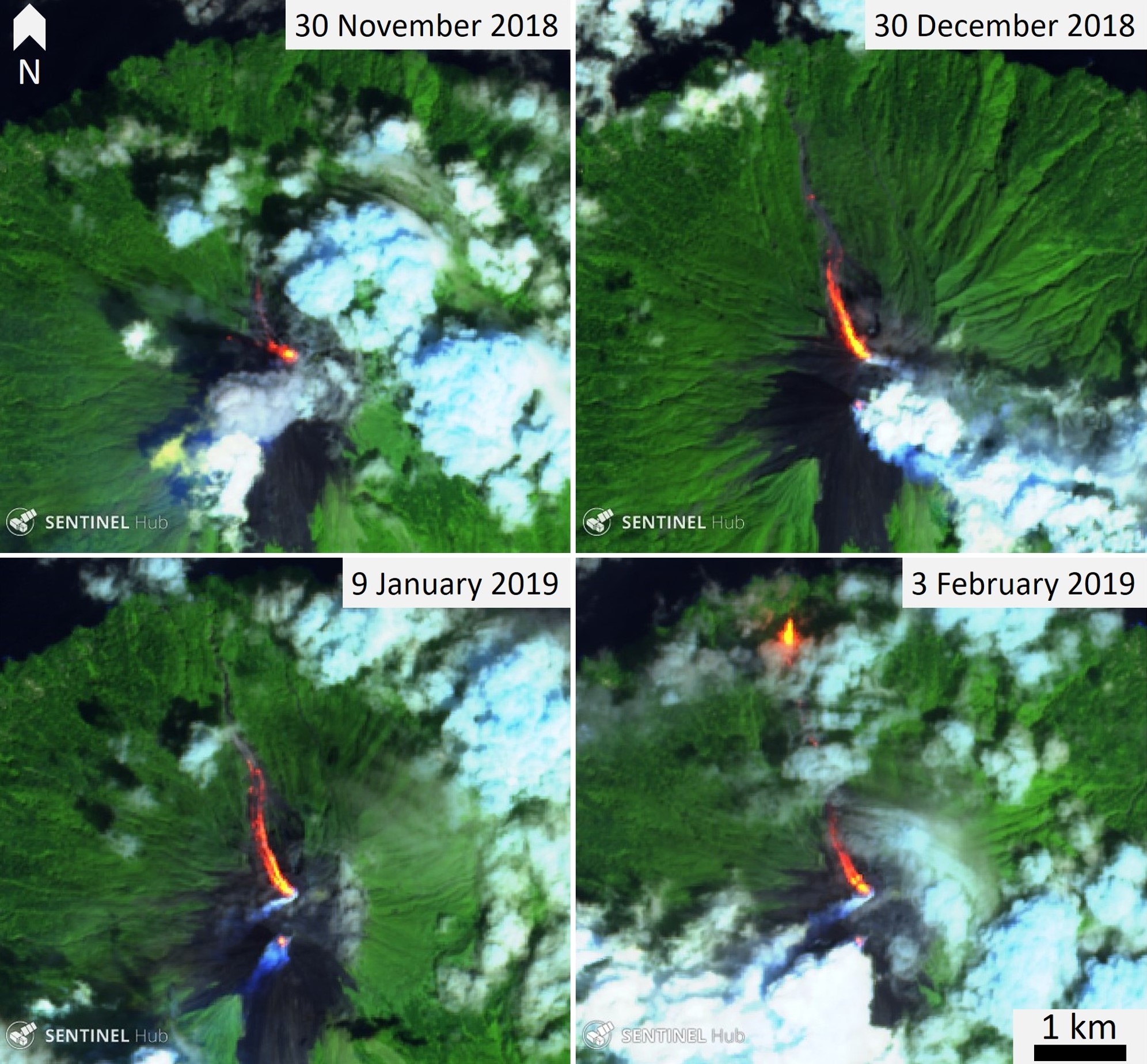 |
Figure 25. Sentinel-2 thermal satellite images of Karangetang during November 2018 through February 2019 showing elevated temperatures at two craters, gas-and-steam plumes, and a lava flow moving to the NW (bright yellow-orange). Sentinel-2 false color (bands 12, 11, 4) images courtesy of Sentinel Hub Playground. |
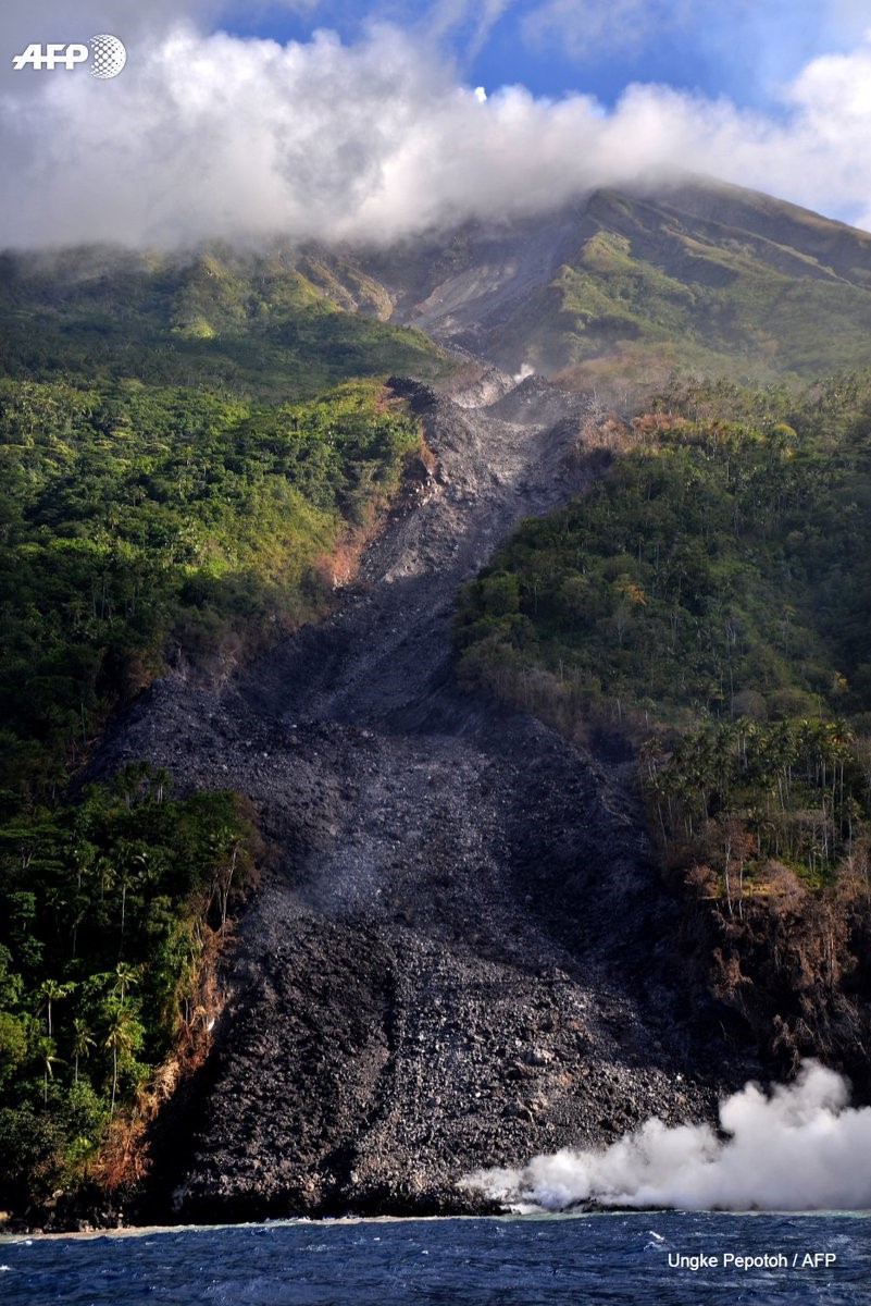 |
Figure 26. View of the active lava flow on Karangetang at the ocean entry in early February 2019. Photo posted on 12 February; taken by Ungke Pepotoh, courtesy of Agence France-Presse. |
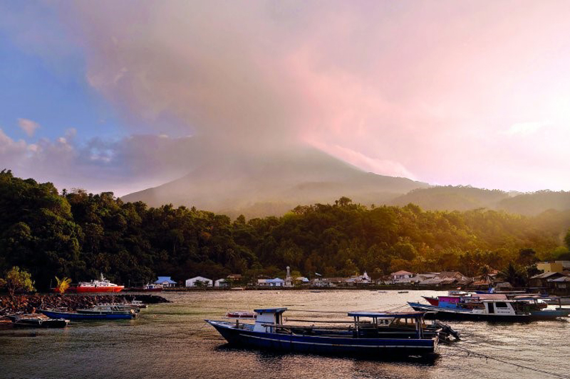 |
Figure 27. Ashfall from Karangetang on Siau Island as seen from Pehe port on 7 February 2019. Photo courtesy of The New Indian Express, AFP / Ungke Pepotoh. |
On 13 February 2019 avalanches continued from the northern crater to 700-1000 m W towards the Sumpihi River and 1-2 km NE towards Kali Batuare. KOMPAS TV reported a statement by PVMBG describing a decrease in activity, including lava avalanches, but with elevated seismicity on the 12 February. Throughout this period of elevated activity both seismicity (figure 28), along with plume heights and directions (figure 29), were variable. On 22 February the Darwin VAAC reported an ash plume, due to a pyroclastic flow, rising to an altitude of 3.7 km.
 |
Figure 28. Graph showing the variable seismicity at Karangetang during 1 November 2018 to 8 February 2019. Courtesy of PVMBG. |
 |
Figure 29. Graph showing gas-and-steam plume heights in meters above the crater from 1 November 2018 to 8 February 2019, with the plume dispersal directions indicated in the box. Modified from data courtesy of PVMBG. |
Throughout March 2019 PVMBG reported the continuation of a low rate of lava effusion at the north crater, avalanches, and gas-and-steam plumes rising up to 500 m above the crater. The Darwin VAAC reported an ash plume on 7 March that rose to an altitude of 2.7 km that dispersed to the SW. Minor ash emissions were reported by the Darwin VAAC on 6 April that rose to 2.1 km altitude and drifted SE. In mid-April, activity increased in the southern crater and on 15 April a pyroclastic flow traveled 2 km towards the Kahetang and Batuawang rivers. Another ash advisory was issued for an ash plume up to 2.4 km altitude on 16 April. Small gas-and-steam plumes continued through the month.
Information Contacts: Pusat Vulkanologi dan Mitigasi Bencana Geologi (PVMBG, also known as Indonesian Center for Volcanology and Geological Hazard Mitigation, CVGHM), Jalan Diponegoro 57, Bandung 40122, Indonesia (URL: http://www.vsi.esdm.go.id/); MAGMA Indonesia, Kementerian Energi dan Sumber Daya Mineral (URL: https://magma.vsi.esdm.go.id/); Badan Nasional Penanggulangan Bencana (BNPB), National Disaster Management Agency, Graha BNPB - Jl. Scout Kav.38, East Jakarta 13120, Indonesia (URL: http://www.bnpb.go.id/); Darwin Volcanic Ash Advisory Centre (VAAC), Bureau of Meteorology, Northern Territory Regional Office, PO Box 40050, Casuarina, NT 0811, Australia (URL: http://www.bom.gov.au/info/vaac/); Sentinel Hub Playground (URL: https://www.sentinel-hub.com/explore/sentinel-playground); MIROVA (Middle InfraRed Observation of Volcanic Activity), a collaborative project between the Universities of Turin and Florence (Italy) supported by the Centre for Volcanic Risk of the Italian Civil Protection Department (URL: http://www.mirovaweb.it/); Hawai'i Institute of Geophysics and Planetology (HIGP) - MODVOLC Thermal Alerts System, School of Ocean and Earth Science and Technology (SOEST), Univ. of Hawai'i, 2525 Correa Road, Honolulu, HI 96822, USA (URL: http://modis.higp.hawaii.edu/); Agence France-Presse (URL: http://www.afp.com/); Kompas TV, Menara Kompas Lt. 6, Jl. Palmerah Selatan No.21, Jakarta Pusat 10270 Indonesia (URL: https://www.kompas.tv/article/39190/abu-gunung-karangetang-tutup-permukiman-warga); The New Indian Express (URL: http://www.newindianexpress.com/world/2019/feb/08/emergency-declared-on-indonesian-island-after-volcanic-eruption-1936173.html); Øystein Lund Andersen (Twitter: @OysteinLAnderse, https://twitter.com/OysteinLAnderse, URL: https://www.oysteinlundandersen.com).
Lava flows, strong thermal anomalies, gas-and-steam emissions, and ash plumes during May-November 2019
Karangetang (also known as Api Siau), located on the island of Siau in the Sitaro Regency, North Sulawesi, Indonesia, has experienced more than 40 recorded eruptions since 1675 in addition to many smaller undocumented eruptions. In early February 2019, a lava flow originated from the N crater (Kawah Dua) traveling NNW and reaching a distance over 3 km. Recent monitoring showed a lava flow from the S crater (Kawah Utama, also considered the "Main Crater") traveling toward the Kahetang and Batuawang River drainages on 15 April 2019. Gas-and-steam emissions, ash plumes, moderate seismicity, and thermal anomalies including lava flow activity define this current reporting period for May through November 2019. The primary source of information for this report comes from daily and weekly reports by the Pusat Vulkanologi dan Mitigasi Bencana Geologi (PVMBG, also known as CVGHM, or the Center of Volcanology and Geological Hazard Mitigation), the Darwin Volcanic Ash Advisory Center (VAAC), and satellite data.
PVMBG reported that white gas-and-steam emissions were visible rising above both craters consistently between May through November 2019 (figures 30 and 31). The maximum altitude for these emissions was 400 m above the Dua Crater on 27 May and 700 m above the Main Crater on 12 June. Throughout the reporting period PVMBG noted that moderate seismicity occurred, which included both shallow and deep volcanic earthquakes.
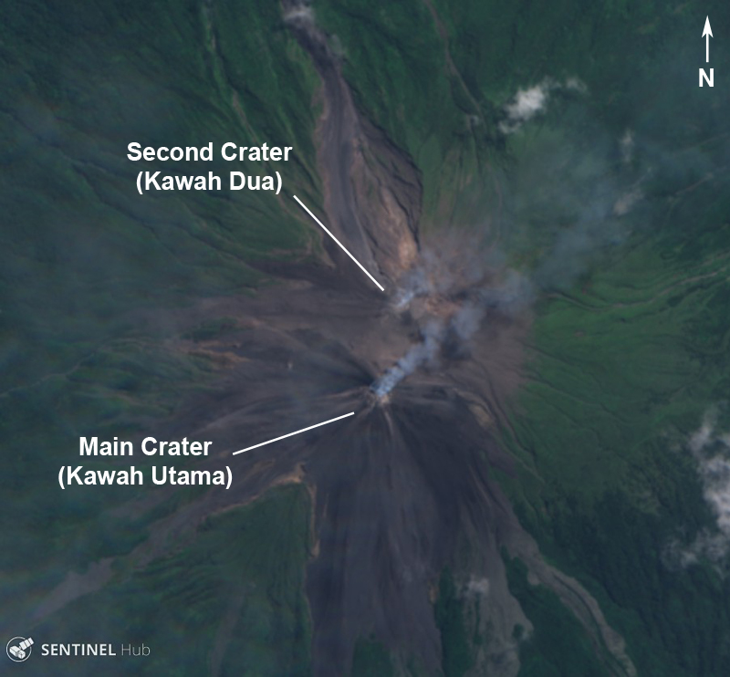 |
Figure 30. A Sentinel-2 image of Karangetang showing two active craters producing gas-and-steam emissions with a small amount of ash on 7 August 2019. Courtesy of Sentinel Hub Playground. |
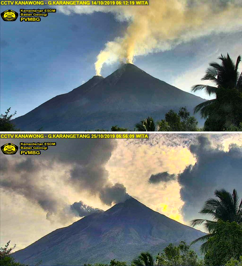 |
Figure 31. Webcam images of gas-and-steam emissions rising from the summit of Karangetang on 14 (top) and 25 (bottom) October 2019. Courtesy of PVMBG via Øystein Lund Andersen. |
Activity was relatively low between May and June 2019, consisting mostly of gas-and-steam emissions. On 26-27 May 2019 crater incandescence was observed above the Main Crater; white gas-and-steam emissions were rising from both craters (figures 32 and 33). At 1858 on 20 July, incandescent avalanches of material originating from the Main Crater traveled as far as 1 km W toward the Pangi and Kinali River drainages. By 22 July the incandescent material had traveled another 500 m in the same direction as well as 1 km in the direction of the Nanitu and Beha River drainages. According to a Darwin VAAC report, discreet, intermittent ash eruptions on 30 July resulted in plumes drifting W at 7.6 km altitude and SE at 3 km, as observed in HIMAWARI-8 satellite imagery.
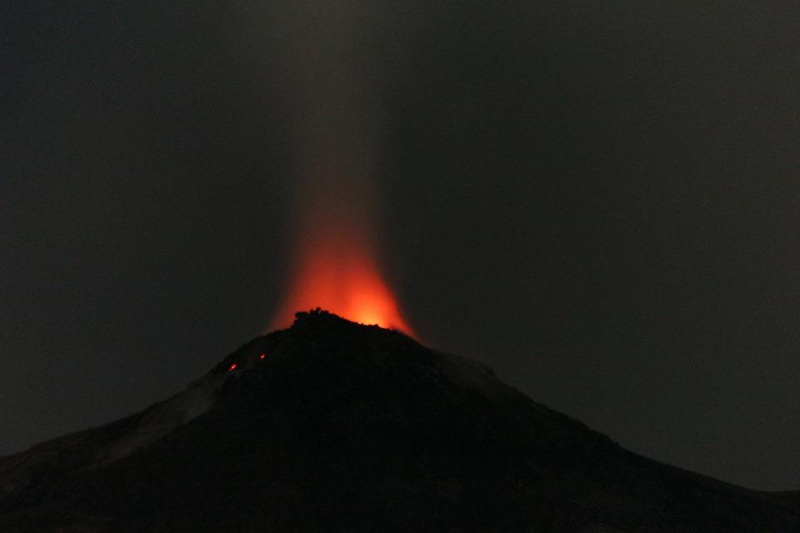 |
Figure 32. Photograph of summit crater incandescence at Karangetang on 12 May 2019. Courtesy of Dominik Derek. |
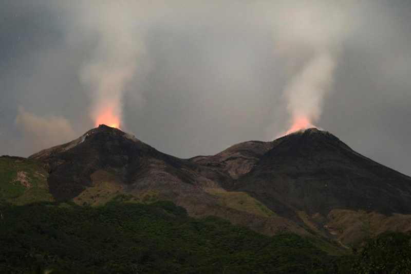 |
Figure 33. Photograph of both summit crater incandescence at Karangetang on 12 May 2019 accompanied by gas-and-steam emissions. Courtesy of Dominik Derek. |
On 5 August 2019 a minor eruption produced an ash cloud that rose 3 km and drifted E. PVMBG reported in the weekly report for 5-11 August that an incandescent lava flow from the Main Crater was traveling W and SW on the slopes of Karangetang and producing incandescent avalanches (figure 34). During 12 August through 1 September lava continued to effuse from both the Main and Dua craters. Avalanches of material traveled as far as 1.5 km SW toward the Nanitu and Pangi River drainages, 1.4-2 km to the W of Pangi, and 1.8 km down the Sense River drainage. Lava fountaining was observed occurring up to 10 m above the summit on 14-20 August.
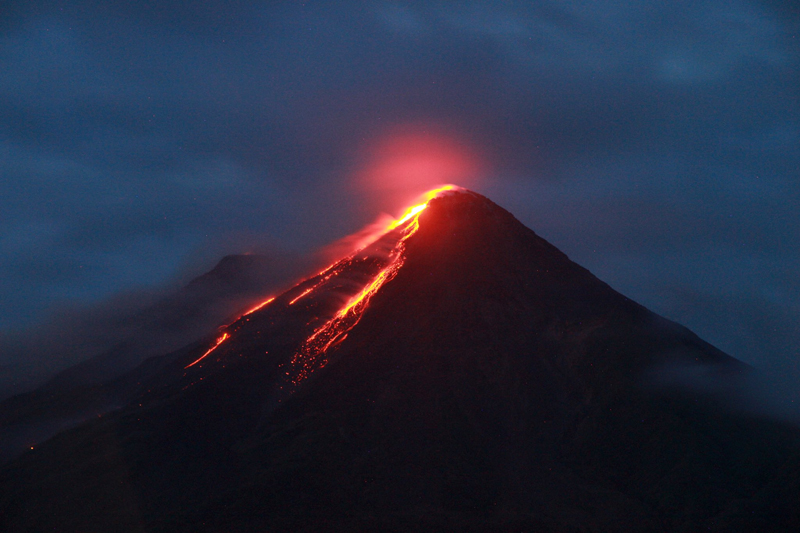 |
Figure 34. Photograph of summit crater incandescence and a lava flow from Karangetang on 7 August 2019. Courtesy of MAGMA Indonesia. |
PVMBG reported that during 2-22 September lava continued to effuse from both craters, traveling SW toward the Nanitu, Pangi, and Sense River drainages as far as 1.5 km. On 24 September the lava flow occasionally traveled 0.8-1.5 km toward the West Beha River drainage. The lava flow from the Main Crater continued through at least the end of November, moving SW and W as far as 1.5 km toward the Nanitu, Pangi, and Sense River drainages. In late October and onwards, incandescence from both summit craters was observed at night. The lava flow often traveled as far as 1 km toward the Batang and East Beha River drainage on 12 November, the West Beha River drainage on 15, 22, 24, and 29 November, and the Batang and West Beha River drainages on 25-27 November (figure 35). On 30 November a Strombolian eruption occurred in the Main Crater accompanied by gas-and-steam emissions rising 100 m above the Main Crater and 50 m above the Dua Crater. Lava flows traveled SW and W toward the Nanitu, Sense, and Pangi River drainages as far as 1.5 km, the West Beha and Batang River drainages as far as 1 km, and occasionally the Batu Awang and Kahetang River drainages as far as 2 km. Lava fountaining was reported occurring 10-25 m above the Main Crater and 10 m above the Dua Crater on 6, 8-12, 15, 21-30 November.
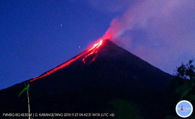 |
Figure 35. Webcam image of gas-and-steam emissions rising from the summit of Karangetang accompanied by incandescence and lava flows at night on 27 November 2019. Courtesy of MAGMA Indonesia via Øystein Lund Andersen. |
MIROVA (Middle InfraRed Observation of Volcanic Activity) analysis of MODIS satellite data showed consistent and strong thermal anomalies within 5 km of the summit craters from late July through November 2019 (figure 36). Satellite imagery from Sentinel-2 corroborated this data, showing strong thermal anomalies and lava flows originating from both craters during this same timeframe (figure 37). In addition to these lava flows, satellite imagery also captured intermittent gas-and-steam emissions from May through November (figure 38). MODVOLC thermal alerts registered 165 thermal hotspots near Karangetang's summit between May and November.
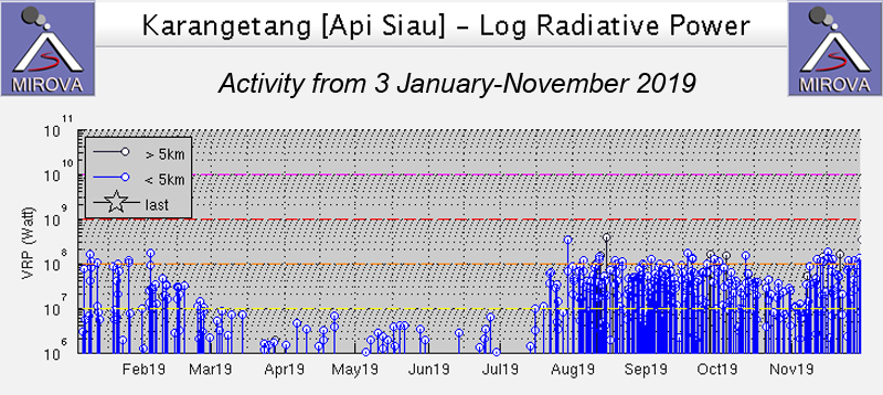 |
Figure 36. Frequent and strong thermal anomalies at Karangetang between 3 January through November 2019 as recorded by the MIROVA system (Log Radiative Power) began in late July and were recorded within 5 km of the summit craters. Courtesy of MIROVA. |
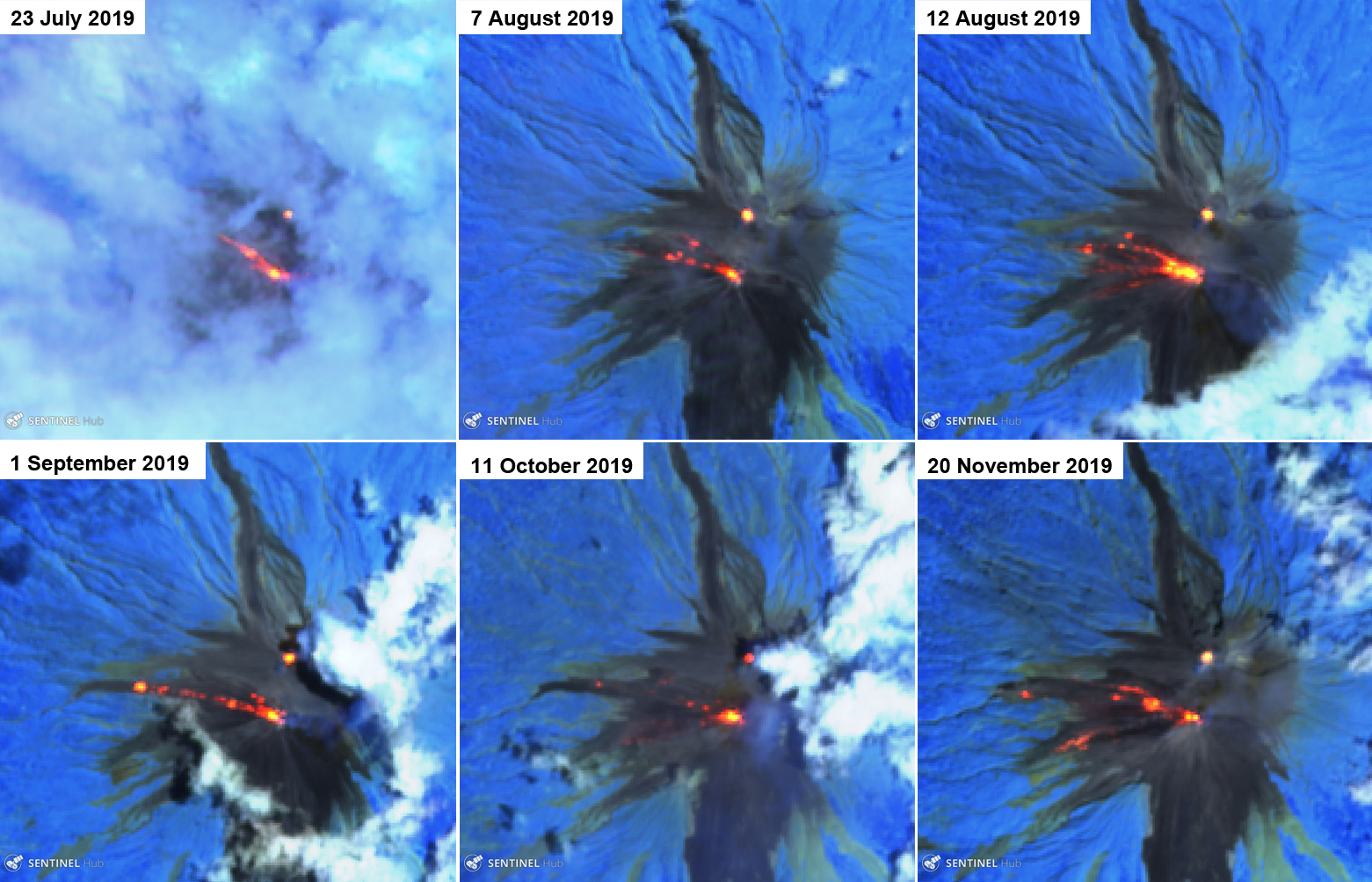 |
Figure 37. Sentinel-2 thermal satellite imagery (bands 12, 11, 8A) confirmed ongoing thermal activity (bright orange) at Karangetang from July into November 2019. The lava flows traveled dominantly in the W direction from the Main Crater. Courtesy of Sentinel Hub Playground. |
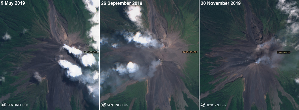 |
Figure 38. Sentinel-2 satellite imagery showing gas-and-steam emissions with a small amount of ash (middle and right) rising from both craters of Karangetang during May through November 2019. Courtesy of Sentinel Hub Playground. |
Sentinel-5P/TROPOMI satellite data detected multiple sulfur dioxide plumes between May and November 2019 (figure 39). These emissions occasionally exceeded 2 Dobson Units (DU) and drifted in different directions based on the dominant wind pattern.
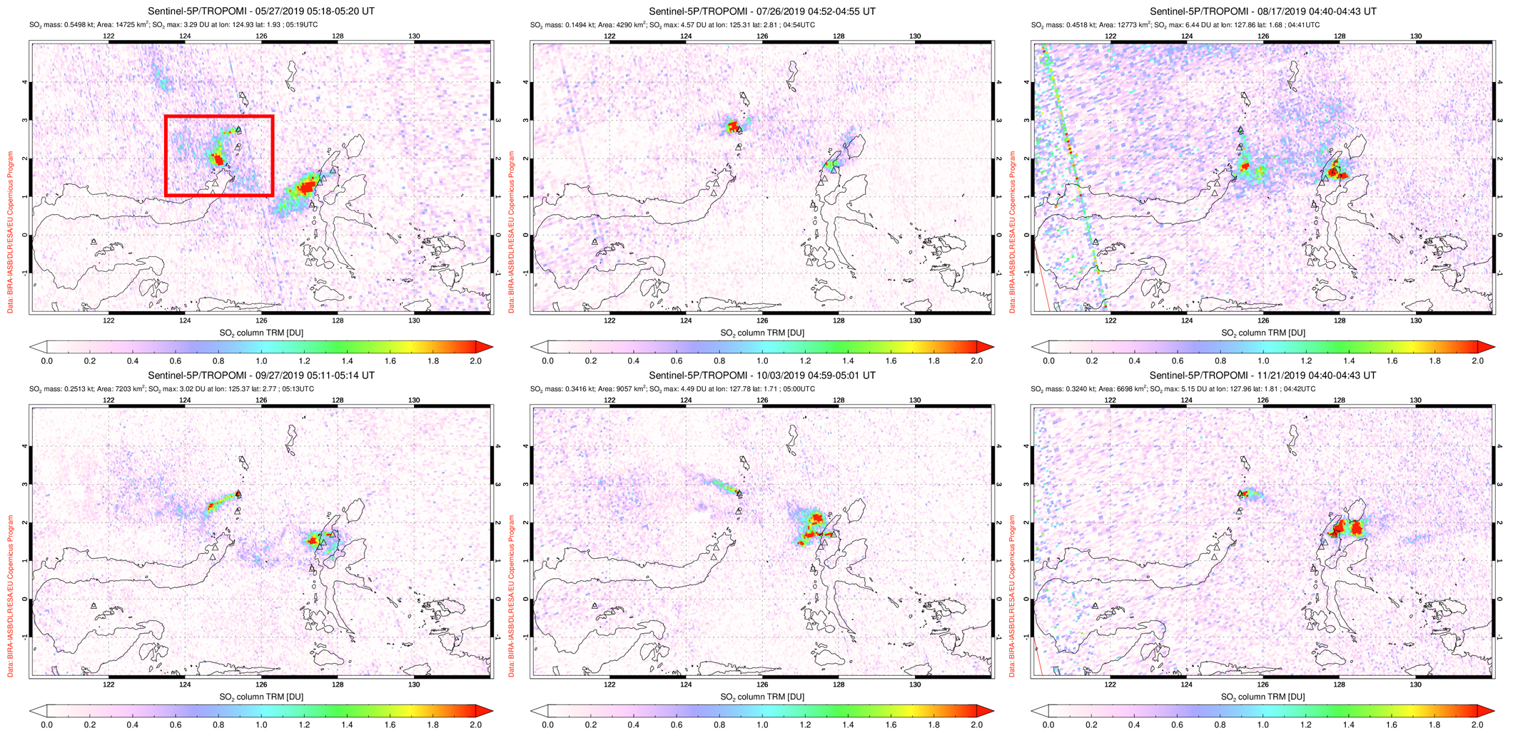 |
Figure 39. SO2 emissions from Karangetang (indicated by the red box) were seen in TROPOMI instrument satellite data during May through November 2019, many of which drifted in different directions based on the prevailing winds. Top left: 27 May 2019. Top middle: 26 July 2019. Top right: 17 August 2019. Bottom left: 27 September 2019. Bottom middle: 3 October 2019. Bottom right: 21 November 2019. Courtesy of NASA Goddard Space Flight Center. |
Information Contacts: Pusat Vulkanologi dan Mitigasi Bencana Geologi (PVMBG, also known as Indonesian Center for Volcanology and Geological Hazard Mitigation, CVGHM), Jalan Diponegoro 57, Bandung 40122, Indonesia (URL: http://www.vsi.esdm.go.id/); MAGMA Indonesia, Kementerian Energi dan Sumber Daya Mineral (URL: https://magma.vsi.esdm.go.id/); Darwin Volcanic Ash Advisory Centre (VAAC), Bureau of Meteorology, Northern Territory Regional Office, PO Box 40050, Casuarina, NT 0811, Australia (URL: http://www.bom.gov.au/info/vaac/); MIROVA (Middle InfraRed Observation of Volcanic Activity), a collaborative project between the Universities of Turin and Florence (Italy) supported by the Centre for Volcanic Risk of the Italian Civil Protection Department (URL: http://www.mirovaweb.it/); Hawai'i Institute of Geophysics and Planetology (HIGP) - MODVOLC Thermal Alerts System, School of Ocean and Earth Science and Technology (SOEST), Univ. of Hawai'i, 2525 Correa Road, Honolulu, HI 96822, USA (URL: http://modis.higp.hawaii.edu/); Global Sulfur Dioxide Monitoring Page, Atmospheric Chemistry and Dynamics Laboratory, NASA Goddard Space Flight Center (NASA/GSFC), 8800 Greenbelt Road, Goddard, Maryland, USA (URL: https://SO2.gsfc.nasa.gov/); Sentinel Hub Playground (URL: https://www.sentinel-hub.com/explore/sentinel-playground); Øystein Lund Andersen (Twitter: @OysteinLAnderse, https://twitter.com/OysteinLAnderse, URL: https://www.oysteinlundandersen.com); Dominik Derek (URL: https://www.facebook.com/07dominikderek/).
Incandescent block avalanches through mid-January 2020; crater anomalies through May
The Karangetang andesitic-basaltic stratovolcano (also referred to as Api Siau) at the northern end of the island of Siau, north of Sulawesi, Indonesia, has had more than 50 observed eruptions since 1675. Frequent explosive activity is accompanied by pyroclastic flows and lahars, and lava-dome growth has created two active summit craters (Main to the S and Second Crater to the N). Rock avalanches, observed incandescence, and satellite thermal anomalies at the summit confirmed continuing volcanic activity since the latest eruption started in November 2018 (BGVN 44:05). This report covers activity from December 2019 through May 2020. Activity is monitored by Indonesia's Pusat Vulkanologi dan Mitigasi Bencana Geologi (PVMBG, also known as CVGHM, or the Center of Volcanology and Geological Hazard Mitigation), and ash plumes are monitored by the Darwin VAAC (Volcanic Ash Advisory Center). Information is also available from MODIS thermal anomaly satellite data through both the University of Hawaii's MODVOLC system and the Italian MIROVA project.
Increased activity that included daily incandescent avalanche blocks traveling down the W and NW flanks lasted from mid-July 2019 (BGVN 44:12) through mid-January 2020 according to multiple sources. The MIROVA data showed increased number and intensity of thermal anomalies during this period, with a sharp drop during the second half of January (figure 40). The MODVOLC thermal alert data reported 29 alerts in December and ten alerts in January, ending on 14 January, with no further alerts through May 2020. During December and the first half of January incandescent blocks traveled 1,000-1,500 m down multiple drainages on the W and NW flanks (figure 41). After this, thermal anomalies were still present at the summit craters, but no additional activity down the flanks was identified in remote satellite data or direct daily observations from PVMBG.
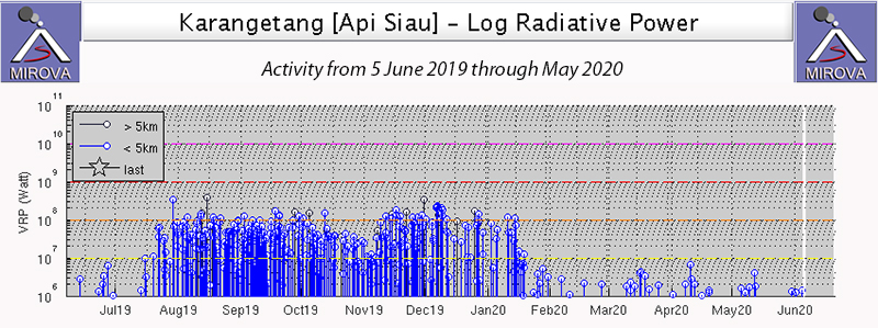 |
Figure 40. An episode of increased activity at Karangetang from mid-July 2019 through mid-January 2020 included incandescent avalanche blocks traveling down multiple flanks of the volcano. This was reflected in increased thermal activity seen during that interval in the MIROVA graph covering 5 June 2019 through May 2020. Courtesy of MIROVA. |
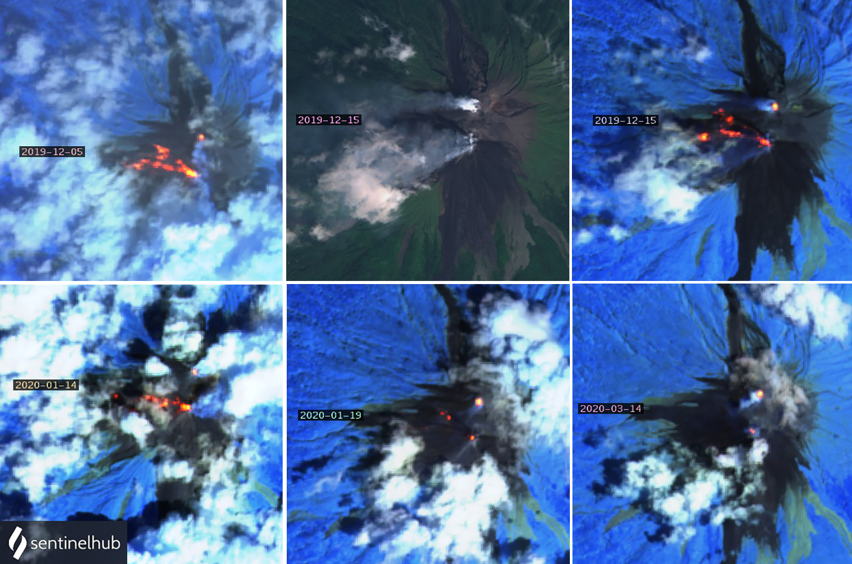 |
Figure 41. An episode of increased activity at Karangetang from mid-July 2019 through mid-January 2020 included incandescent avalanche blocks traveling up to 1,500 m down drainages on the W and NW flanks of the volcano. Top left: large thermal anomalies trend NW from Main Crater on 5 December 2019; about 500 m N a thermal anomaly glows from Second Crater. Top center: on 15 December plumes of steam and gas drifted W and SW from both summit craters as seen in Natural Color rendering (bands 4,3,2). Top right: the same image as at top center with Atmospheric penetration rendering (bands 12, 11, 8a) shows hot zones extending WNW from Main Crater and a thermal anomaly at Second Crater. Bottom left: thermal activity seen on 14 January 2020 extended about 800 m WNW from Main Crater along with an anomaly at Second Crater and a hot spot about 1 km W. Bottom center: by 19 January the anomaly from Second Crater appeared slightly stronger than at Main Crater, and only small anomalies appeared on the NW flank. Bottom right: an image from 14 March shows only thermal anomalies at the two summit craters. Courtesy of Sentinel Hub Playground. |
A single VAAC report in early April noted a short-lived ash plume that drifted SW. Intermittent low-level activity continued through May 2020. Small SO2 plumes appeared in satellite data multiple times in December 2019 and January 2020; they decreased in size and frequency after that but were still intermittently recorded into May 2020 (figure 42).
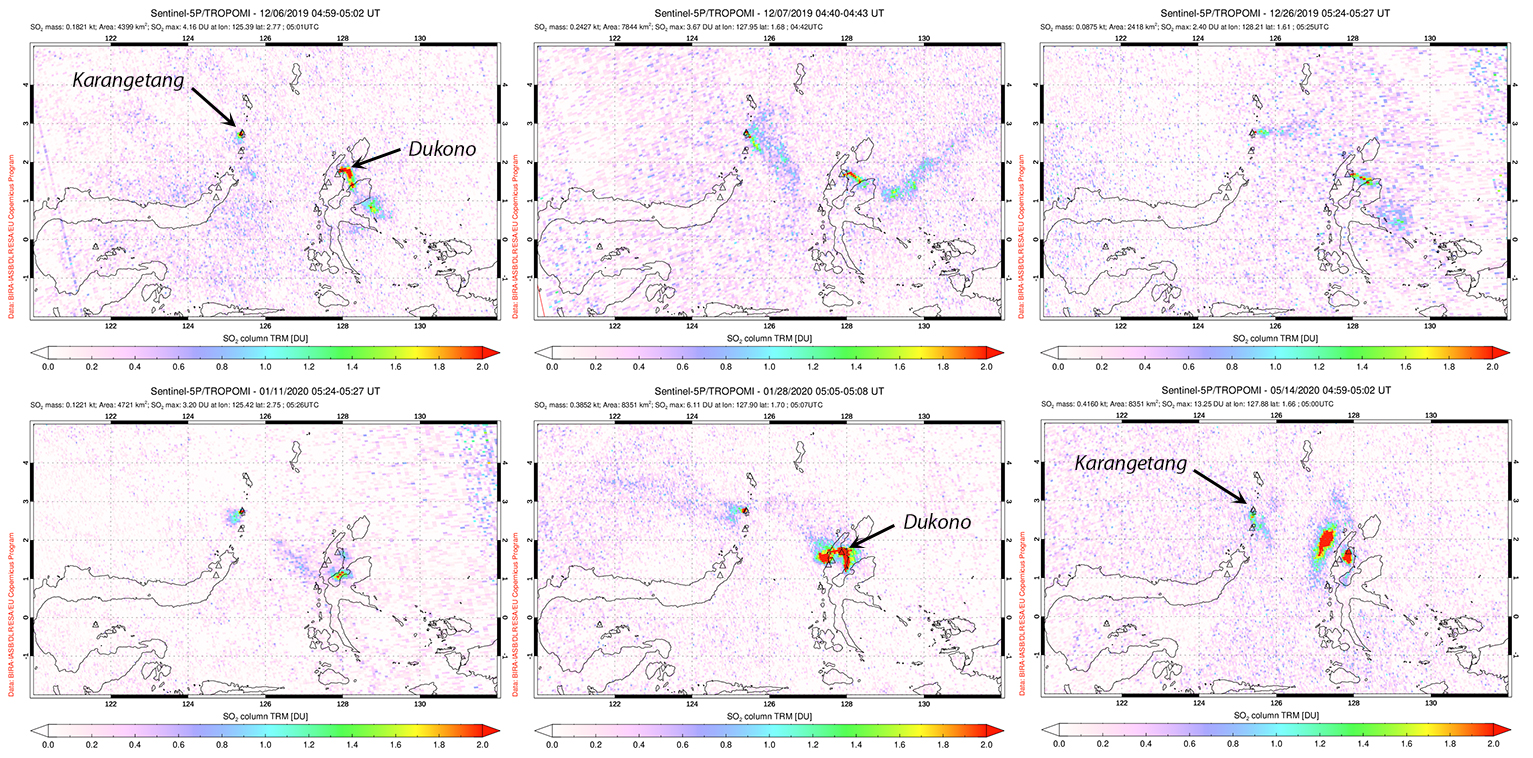 |
Figure 42. Small plumes of sulfur dioxide were measured at Karangetang with the TROPOMI instrument on the Sentinel-5P satellite multiple times during December 2019 (top row). They were less frequent but still appeared during January-May 2020 (bottom row). Larger plumes were also detected from Dukono, located 300 km ESE at the N end of North Maluku. Courtesy of Global Sulfur Dioxide Monitoring Page. |
PVMBG reported in their daily summaries that steam plumes rose 50-150 m above the Main Crater and 25-50 m above Second Crater on most days in December. The incandescent avalanche activity that began in mid-July 2019 also continued throughout December 2019 and January 2020 (figure 43). Incandescent blocks from the Main Crater descended river drainages (Kali) on the W and NW flanks throughout December. They were reported nearly every day in the Nanitu, Sense, and Pangi drainages, traveling 1,000-1,500 m. Incandescence from both craters was visible 10-25 m above the crater rim most nights.
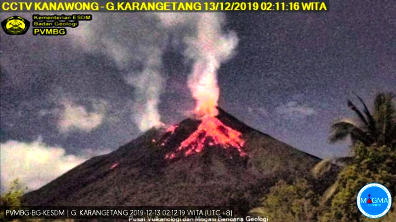 |
Figure 43. Incandescent block avalanches descended the NW flank of Karangetang as far as 1,500 m frequently during December 2019. Image taken 13 December 2019. Courtesy of PVMBG, Oystein Andersen. |
A few blocks were noted traveling 800 m down Kali Beha Barat on 1 December. Incandescence above the Main crater reached 50-75 m during 4-6 December. During 4-7 December incandescent blocks appeared in Kali Sesepe, traveling 1,000-1,500 m down from the summit. They were also reported in Kali Batang and Beha Barat during 4-14 December, usually moving 800-1,000 m downslope. Between 5 and 14 December, gray and white plumes from Second Crater reached 300 m multiple times. During 12-15 December steam plumes rose 300-500 m above the Main crater. Activity decreased during 18-26 December but increased again during the last few days of the month. On 28 December, incandescent blocks were reported 1,500 m down Kali Pangi and Nanitu, and 1,750 m down Kali Sense.
Incandescent blocks were reported in Kali Sesepi during 4-6 January and in Kali Batang and Beha Barat during 4-8 and 12-15 January (figure 44); they often traveled 800-1,200 m downslope. Activity tapered off in those drainages and incandescent blocks were last reported in Kali Beha Barat on 15 January traveling 800 m from the summit. Incandescent blocks were also reported traveling usually 1,000-1,500 m down the Nanitu, Sense, and Pangi drainages during 4-19 January. Blocks continued to occasionally descend up to 1,000 m down Kali Nanitu through 24 January. Pulses of activity occurred at the summit of Second Crater a few times in January. Steam plumes rose 25-50 m during 8-9 January and again during 16-31 January, with plumes rising 300-400 m on 20, 29, and 31 January. Incandescence was noted 10-25 m above the summit of Second Crater during 27-30 January.
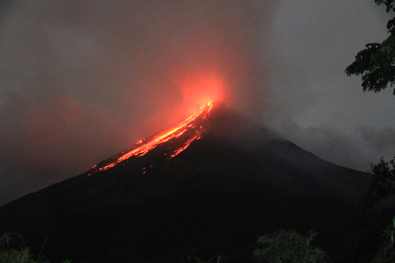 |
Figure 44. Incandescent material descends the Beha Barat, Sense, Nanitu, and Pangi drainages on the NW flank of Karangetang in early January 2020. Courtesy of Bobyson Lamanepa; posted on Twitter on 6 January 2020. |
Activity diminished significantly after mid-January 2020. Steam plumes at the Main Crater rose 50-100 m on the few days where the summit was not obscured by fog during February. Faint incandescence occurred at the Main Crater on 7 February, and steam plumes rising 25-50 m from Second Crater that day were the only events reported there in February. During March, steam plumes persisted from the Main Crater, with heights of over 100 m during short periods from 8-16 March and 25-30 March. Weak incandescence was reported from the Main Crater only once, on 25 March. Very little activity occurred at Second Crater during March, with only steam plumes reported rising 25-300 m from the 22nd to the 28th (figure 45).
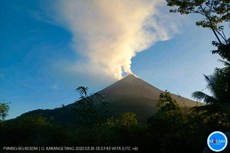 |
Figure 45. Steam plumes at Karangetang rose over 100 m above both summit craters multiple times during March, including on 26 March 2020. Courtesy of PVMBG and Oystein Andersen. |
The Darwin VAAC reported a continuous ash emission on 4 April 2020 that rose to 2.1 km altitude and drifted SW for a few hours before dissipating. Incandescence visible 25 m above both craters on 13 April was the only April activity reported by PVMBG other than steam plumes from the Main Crater that rose 50-500 m on most days. Steam plumes of 50-100 m were reported from Second Crater during 11-13 April. Activity remained sporadic throughout May 2020. Steam plumes from the Main Crater rose 50-300 m each day. Satellite imagery identified steam plumes and incandescence from both summit craters on 3 May (figure 46). Faint incandescence was observed at the Main Crater on 12 and 27 May. Steam plumes rose 25-50 m from Second Crater on a few days; a 200-m-high plume was reported on 27 May. Bluish emissions were observed on the S and SW flanks on 28 May.
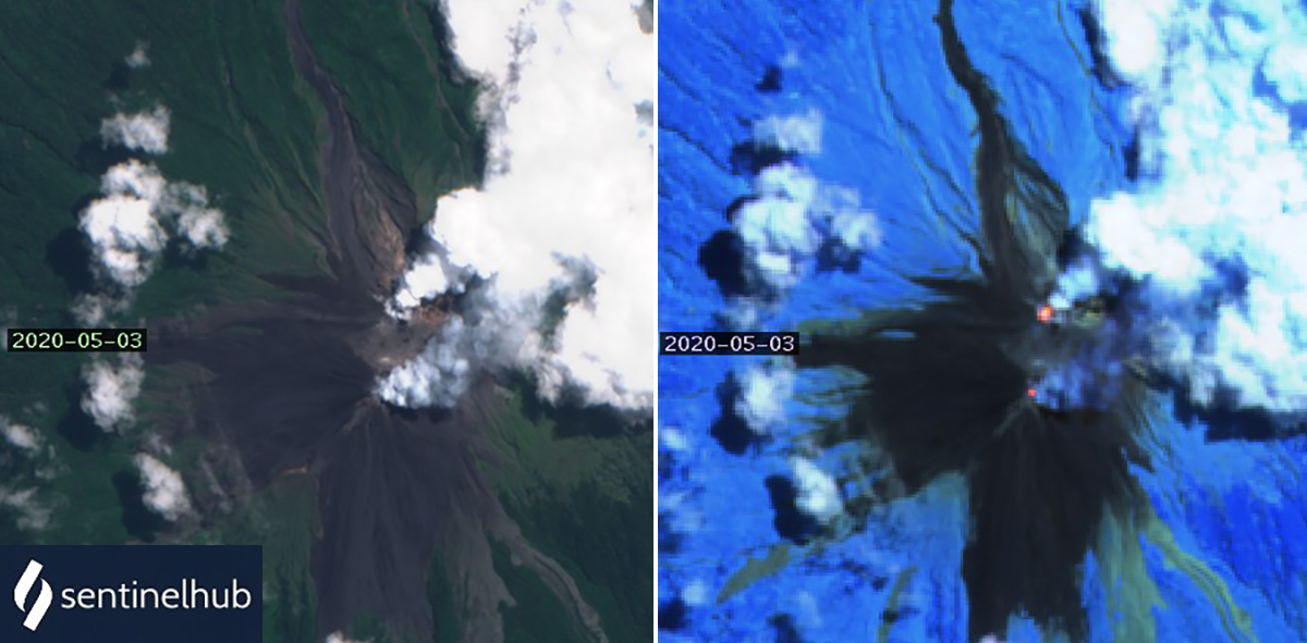 |
Figure 46. Dense steam plumes and thermal anomalies were present at both summit craters of Karangetang on 3 May 2020. Sentinel 2 satellite image with Natural Color (bands 4, 3, 2) (left) and Atmospheric Penetration rendering (bands 12, 11, 8a) (right); courtesy of Sentinel Hub Playground. |
Information Contacts: Pusat Vulkanologi dan Mitigasi Bencana Geologi (PVMBG, also known as Indonesian Center for Volcanology and Geological Hazard Mitigation, CVGHM), Jalan Diponegoro 57, Bandung 40122, Indonesia (URL: http://www.vsi.esdm.go.id/); MIROVA (Middle InfraRed Observation of Volcanic Activity), a collaborative project between the Universities of Turin and Florence (Italy) supported by the Centre for Volcanic Risk of the Italian Civil Protection Department (URL: http://www.mirovaweb.it/); Hawai'i Institute of Geophysics and Planetology (HIGP) - MODVOLC Thermal Alerts System, School of Ocean and Earth Science and Technology (SOEST), Univ. of Hawai'i, 2525 Correa Road, Honolulu, HI 96822, USA (URL: http://modis.higp.hawaii.edu/); Sentinel Hub Playground (URL: https://www.sentinel-hub.com/explore/sentinel-playground); Global Sulfur Dioxide Monitoring Page, Atmospheric Chemistry and Dynamics Laboratory, NASA Goddard Space Flight Center (NASA/GSFC), 8800 Greenbelt Road, Goddard, Maryland, USA (URL: https://so2.gsfc.nasa.gov/); Darwin Volcanic Ash Advisory Centre (VAAC), Bureau of Meteorology, Northern Territory Regional Office, PO Box 40050, Casuarina, NT 0811, Australia (URL: http://www.bom.gov.au/info/vaac/); Øystein Lund Andersen (Twitter: @OysteinLAnderse, https://twitter.com/OysteinLAnderse, URL: http://www.oysteinlundandersen.com); Bobyson Lamanepa, Yogyakarta, Indonesia, (URL: https://twitter.com/BobyLamanepa/status/1214165637028728832).
Hot material on the NW flank in November 2020; intermittent crater thermal anomalies
Karangetang (also known as Api Siau) is located on the island of Siau in the Sitaro Regency, North Sulawesi, Indonesia and consists of two active summit craters: a N crater (Kawah Dua) and a S crater (Kawah Utama, also referred to as the “Main Crater”). More than 50 eruptions have been observed since 1675. The current eruption began in November 2018 and has recently been characterized by frequent incandescent block avalanches, thermal anomalies in the crater, and gas-and-steam plumes (BGVN 45:06). This report covers activity from June through November 2020, which includes dominantly crater anomalies, few ash plumes, and gas-and-steam emissions. Information primarily comes from the Pusat Vulkanologi dan Mitigasi Bencana Geologi (PVMBG, also known as CVGHM, or the Center of Volcanology and Geological Hazard Mitigation), MAGMA Indonesia, and various satellite data.
Activity decreased significantly after mid-January 2020 and has been characterized by dominantly gas-and-steam emissions and occasional ash plumes, according to PVMBG. Daily gas-and-steam emissions were observed rising 25-600 m above the Main Crater (S crater) during the reporting period and intermittent emissions rising 25-300 m above Kawah Dua (N crater).
The only activity reported by PVMBG in June, August, and October was daily gas-and-steam emissions above the Main Crater and Kawah Dua (figure 47). MIROVA (Middle InfraRed Observation of Volcanic Activity) analysis of MODIS satellite data shows intermittent low-power thermal anomalies during June through late July, which includes a slight increase in power during late July (figure 48). During 14-15 July strong rumbling from Kawah Dua was accompanied by white-gray emissions that rose 150-200 m above the crater. Crater incandescence was observed up to 10 m above the crater. According to webcam imagery from MAGMA Indonesia, intermittent incandescence was observed at night from both craters through 25 July. In a Volcano Observatory Notice for Aviation (VONA) issued on 5 September, PVMBG reported an ash plume that rose 800 m above the crater.
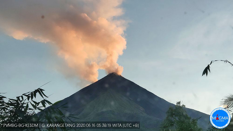 |
Figure 47. Webcam image of gas-and-steam plumes rising above the two summit craters at Karangetang on 16 June 2020. Courtesy of MAGMA Indonesia. |
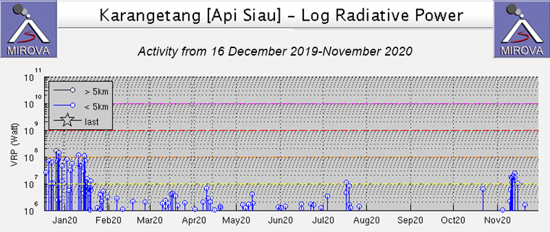 |
Figure 48. Intermittent low-power thermal anomalies at Karangetang were reported during June through July 2020 with a slight increase in power in late July, according to the MIROVA graph (Log Radiative Power). No thermal activity was detected during August to late October; in mid-November a short episode of increased activity occurred. Courtesy of MIROVA. |
Thermal activity increased briefly during mid-November when hot material was reported extending 500-1,000 m NW of the Main Crater, accompanied by gas-and-steam emissions rising 200 m above the crater. Corresponding detection of MODIS thermal anomalies was seen in MIROVA graphs (see figure 48), and the MODVOLC system showed alerts on 13 and 15 November. On 16 November blue emissions were observed above the Main Crater drifting W. Sentinel-2 thermal images showed elevated temperatures in both summit craters throughout the reporting period, accompanied by gas-and-steam emissions and movement of hot material on the NW flank on 19 November (figure 49). White gas-and-steam emissions rose to a maximum height of 300 m above Kawah Dua on 22 November and 600 m above the Main Crater on 28 November.
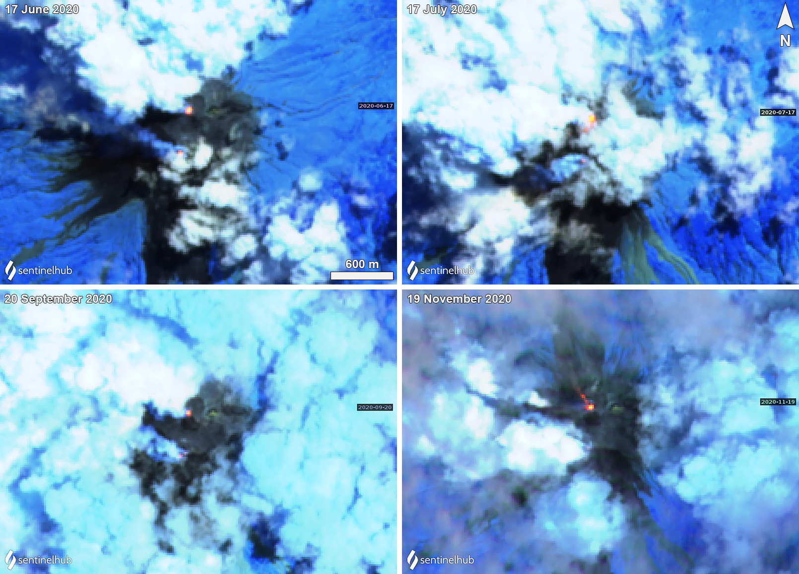 |
Figure 49. Persistent thermal anomalies (bright yellow-orange) at Karangetang were detected in both summit craters using Sentinel-2 thermal satellite imagery during June through November 2020. Gas-and-steam emissions were also occasionally detected in both craters as seen on 17 June (top left) and 20 September (bottom left) 2020. On 19 November (bottom right) the Main Crater (S) showed a hot thermal signature extending NW. Images using “Atmospheric penetration” rendering (bands 12, 11, 8a). Courtesy of Sentinel Hub Playground. |
Information Contacts: Pusat Vulkanologi dan Mitigasi Bencana Geologi (PVMBG, also known as Indonesian Center for Volcanology and Geological Hazard Mitigation, CVGHM), Jalan Diponegoro 57, Bandung 40122, Indonesia (URL: http://www.vsi.esdm.go.id/); MAGMA Indonesia, Kementerian Energi dan Sumber Daya Mineral (URL: https://magma.vsi.esdm.go.id/); MIROVA (Middle InfraRed Observation of Volcanic Activity), a collaborative project between the Universities of Turin and Florence (Italy) supported by the Centre for Volcanic Risk of the Italian Civil Protection Department (URL: http://www.mirovaweb.it/); Hawai'i Institute of Geophysics and Planetology (HIGP) - MODVOLC Thermal Alerts System, School of Ocean and Earth Science and Technology (SOEST), Univ. of Hawai'i, 2525 Correa Road, Honolulu, HI 96822, USA (URL: http://modis.higp.hawaii.edu/); Sentinel Hub Playground (URL: https://www.sentinel-hub.com/explore/sentinel-playground).
Frequent white gas-and-steam emissions, seismicity, and an ash plume on 29 January 2021
Karangetang (also known as Api Siau), located on the island of Siau in the Sitaro Regency, North Sulawesi, Indonesia, consists of two active summit craters: Kawah Dua (the N crater) and Kawah Utama (the S crater, also referred to as the “Main Crater”). Its current eruption period began in November 2018 and has recently been characterized by occasional ash plumes, crater incandescence, an incandescent avalanche, and frequent gas-and-steam emissions (BGVN 45:12). This report updates information during December 2020 through May 2021, describing frequent white gas-and-steam emissions and a single ash plume based on reports from the Pusat Vulkanologi dan Mitigasi Bencana Geologi (PVMBG, also known as CVGHM, or the Center of Volcanology and Geological Hazard Mitigation), MAGMA Indonesia, the Darwin Volcanic Ash Advisory Center (VAAC), and satellite data.
Activity remained relatively low through May 2021 and was primarily characterized by gas-and-steam emissions and occasional ash plumes, according to PVMBG. Frequent gas-and-steam emissions rose 25-600 m above the Main Crater (S crater) during the reporting period and intermittent emissions rose 50-400 m above the N crater.
During December 2020, the volcano was often obscured by clouds and activity was primarily characterized by a low number of volcanic earthquakes, frequent white gas-and-steam emissions rising 50-250 m above the N crater, and occasional emissions rising 25-400 m above the Main Crater. According to PVMBG, seismicity declined during the month.
Similar low-level activity dominated by white gas-and-steam emissions and volcanic earthquakes continued into January 2021; weather often obscured views of the volcano. White gas-and-steam emissions rose 100-300 m above the Main Crater while those from the N crater rose 50-100 m above the crater rim. On 29 January pilots reported that an ash plume reached 2.4 km altitude and drifted SW. Ash plumes continued to be observed to 3 km altitude throughout the night into the 30th, based on satellite imagery, according to the Darwin VAAC.
White gas-and-steam emissions and occasional volcanic earthquakes continued during February through May (figure 50), though weather continued to frequently prevent clear views of the summit. White gas-and-steam emissions rose 25-600 m above the Main Crater and 25-400 m above the N crater. Due to the low-level of activity, PVMBG lowered the Volcano Alert Level to 2 (on a scale of 1-4) on 9 February.
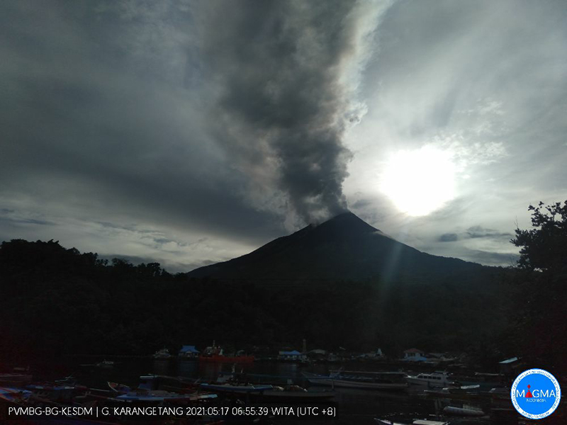 |
Figure 50. Webcam image of Karangetang showing a gas-and-steam plume rising 400 m above the summit on 17 May 2021. Courtesy of MAGMA Indonesia. |
MIROVA (Middle InfraRed Observation of Volcanic Activity) analysis of MODIS satellite data detected intermittent low-power thermal anomalies during the reporting period (figure 51). Sentinel-2 infrared satellite images also showed occasional weak thermal anomalies in the N summit crater and frequent gas-and-steam emissions from both summit craters (figure 52).
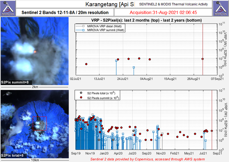 |
Figure 51. Intermittent thermal anomalies (red dots) were detected in the summit area of Karangetang during December 2020-May 2021 as recorded by the Sentinel-2 MODIS Thermal Volcanic Activity data (bands 12, 11, 8A). These anomalies were consistently low in power during the reporting period. Courtesy of MIROVA. |
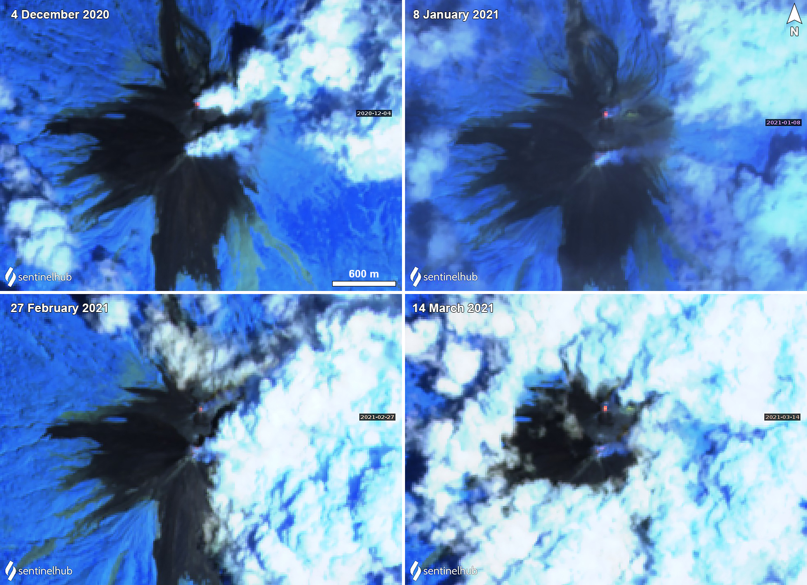 |
Figure 52. Small thermal anomalies (yellow-orange) at Karangetang were detected in the N summit crater on 4 December 2020 (top left), 8 January (top right), 27 February (bottom left), and 14 March (bottom right) 2021. Gas-and-steam emissions were observed from both summit craters drifting generally E on each of those dates; the Main Crater (S) summit crater was dominantly characterized by gas-and-steam emissions. Images using “Atmospheric penetration” rendering (bands 12, 11, 8a). Courtesy of Sentinel Hub Playground. |
Information Contacts: Pusat Vulkanologi dan Mitigasi Bencana Geologi (PVMBG, also known as Indonesian Center for Volcanology and Geological Hazard Mitigation, CVGHM), Jalan Diponegoro 57, Bandung 40122, Indonesia (URL: http://www.vsi.esdm.go.id/); MAGMA Indonesia, Kementerian Energi dan Sumber Daya Mineral (URL: https://magma.esdm.go.id/v1); Darwin Volcanic Ash Advisory Centre (VAAC), Bureau of Meteorology, Northern Territory Regional Office, PO Box 40050, Casuarina, NT 0811, Australia (URL: http://www.bom.gov.au/info/vaac/); MIROVA (Middle InfraRed Observation of Volcanic Activity), a collaborative project between the Universities of Turin and Florence (Italy) supported by the Centre for Volcanic Risk of the Italian Civil Protection Department (URL: http://www.mirovaweb.it/); Sentinel Hub Playground (URL: https://www.sentinel-hub.com/explore/sentinel-playground).
Weak thermal anomalies and gas-and-steam emissions during June-December 2021
Karangetang (also known as Api Siau) is located on the island of Siau in the Sitaro Regency, North Sulawesi, Indonesia, and consists of two active summit craters: Kawah Dua (the N crater) and Kawah Utama (the S crater, also referred to as the “Main Crater”). Its current eruption period began in November 2018 and has more recently been characterized by frequent white gas-and-steam emissions, seismicity, thermal anomalies, and occasional ash plumes (BGVN 46:07). This report updates information during June through December 2021, describing continued white gas-and-steam emissions, thermal anomalies, and intermittent ash plumes, based on reports from the Pusat Vulkanologi dan Mitigasi Bencana Geologi (PVMBG, also known as CVGHM, or the Center of Volcanology and Geological Hazard Mitigation), MAGMA Indonesia, the Darwin Volcanic Ash Advisory Center (VAAC), and satellite data.
Activity during June through December dominantly consisted of white-to-gray gas-and-steam emissions that rose 25-500 m above the Main Crater and 25-50 m above the N crater, according to daily reports from PVMBG. Emissions from the N crater rose 150 m above the crater on 23 December and 200 m above the crater on 24 December. Volcanic earthquakes were also detected. A Darwin VAAC notice reported that on 25 October a pilot observed an ash plume that rose to 3 km altitude and drifted SW. Continuous ash emissions were also visible in satellite images, though they had stopped within five hours. On 24 and 31 December PVMBG reported that incandescence from the N crater was periodically detected 10 m above the crater.
MIROVA (Middle InfraRed Observation of Volcanic Activity) analysis of MODIS satellite data detected intermittent low-power thermal anomalies during the reporting period (figure 53). Sentinel-2 infrared satellite images also showed a thermal anomaly in the N summit crater, a weaker anomaly in the S crater, and intermittent gas-and-steam emissions from both summit craters (figure 54).
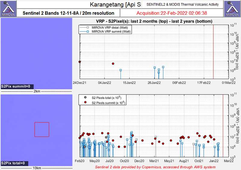 |
Figure 53. Intermittent thermal anomalies (red dots) were detected in the summit area of Karangetang during June through December 2021 as recorded by the Sentinel-2 MODIS Thermal Volcanic Activity data (bands 12, 11, 8A). These anomalies were slightly higher in power during compared to the previous months. Courtesy of MIROVA. |
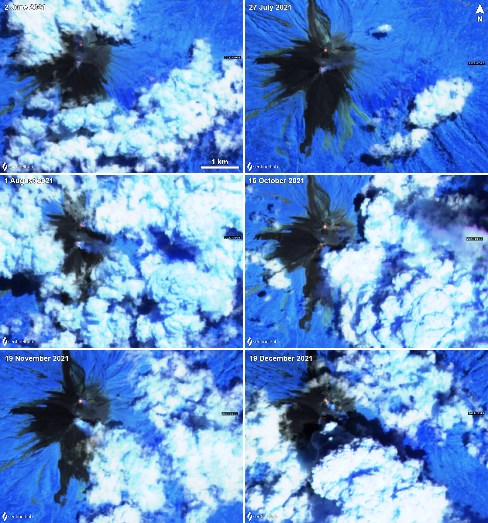 |
Figure 54. Small thermal anomalies (yellow-orange) at Karangetang were detected in the N summit crater on 2 June (top left), 27 July (top right), 1 August (middle left), 15 October (middle right), 19 November (bottom left), and 19 December (bottom right) 2021. A weaker anomaly was also detected in the S summit crater during these dates. Gas-and-steam emissions were observed from both summit craters. Images using “Atmospheric penetration” rendering (bands 12, 11, 8a). Courtesy of Sentinel Hub Playground. |
Information Contacts: Pusat Vulkanologi dan Mitigasi Bencana Geologi (PVMBG, also known as Indonesian Center for Volcanology and Geological Hazard Mitigation, CVGHM), Jalan Diponegoro 57, Bandung 40122, Indonesia (URL: http://www.vsi.esdm.go.id/); MAGMA Indonesia, Kementerian Energi dan Sumber Daya Mineral (URL: https://magma.esdm.go.id/v1); Darwin Volcanic Ash Advisory Centre (VAAC), Bureau of Meteorology, Northern Territory Regional Office, PO Box 40050, Casuarina, NT 0811, Australia (URL: http://www.bom.gov.au/info/vaac/); Darwin Volcanic Ash Advisory Centre (VAAC), Bureau of Meteorology, Northern Territory Regional Office, PO Box 40050, Casuarina, NT 0811, Australia (URL: http://www.bom.gov.au/info/vaac/); MIROVA (Middle InfraRed Observation of Volcanic Activity), a collaborative project between the Universities of Turin and Florence (Italy) supported by the Centre for Volcanic Risk of the Italian Civil Protection Department (URL: http://www.mirovaweb.it/); Sentinel Hub Playground (URL: https://www.sentinel-hub.com/explore/sentinel-playground).
Weak thermal activity during January-June 2022
Karangetang (also known as Api Siau), located on the island of Siau in the Sitaro Regency, consists of two active summit craters: Kawah Dua (the N crater) and Kawah Utama (the S crater, also referred to as the “Main Crater”). Twentieth century eruptions have included frequent explosive activity, sometimes accompanied by pyroclastic flows and lahars. The most recent eruption period began in November 2018 and has more recently consisted of weak thermal anomalies, intermittent ash plumes, and gas-and-steam emissions (BGVN 47:01). Similar activity occurred during this report of January through June 2022, with continued white-to-gray gas-and-steam emissions and thermal anomalies, described in reports from the Pusat Vulkanologi dan Mitigasi Bencana Geologi (PVMBG, also known as CVGHM, or the Center of Volcanology and Geological Hazard Mitigation), MAGMA Indonesia, and satellite data.
Activity was relatively low during this reporting period. Bluish white gas-and-steam emissions drifted S on 2 January and intermittent white-and-gray plumes typically rose 25-250 m above the summit through June (figure 55). On 15 and 16 January gas-and-steam emissions rose as high as 500 m. Intermittent N summit crater incandescence was reported by PVMBG during early January 2022, which was sometimes detected in satellite data. MIROVA (Middle InfraRed Observation of Volcanic Activity) analysis of MODIS satellite data detected very low power thermal anomalies during late January (3), late April (1), and early May (1). Sentinel-2 infrared thermal satellite imagery showed small thermal anomalies in both the N and S summit craters on 8 January, 27 February, 9 March, 18 and 28 April, 3 May, and 2, 17, 22, and 27 June, accompanied by gas-and-steam emissions that drifted in different directions (figure 56).
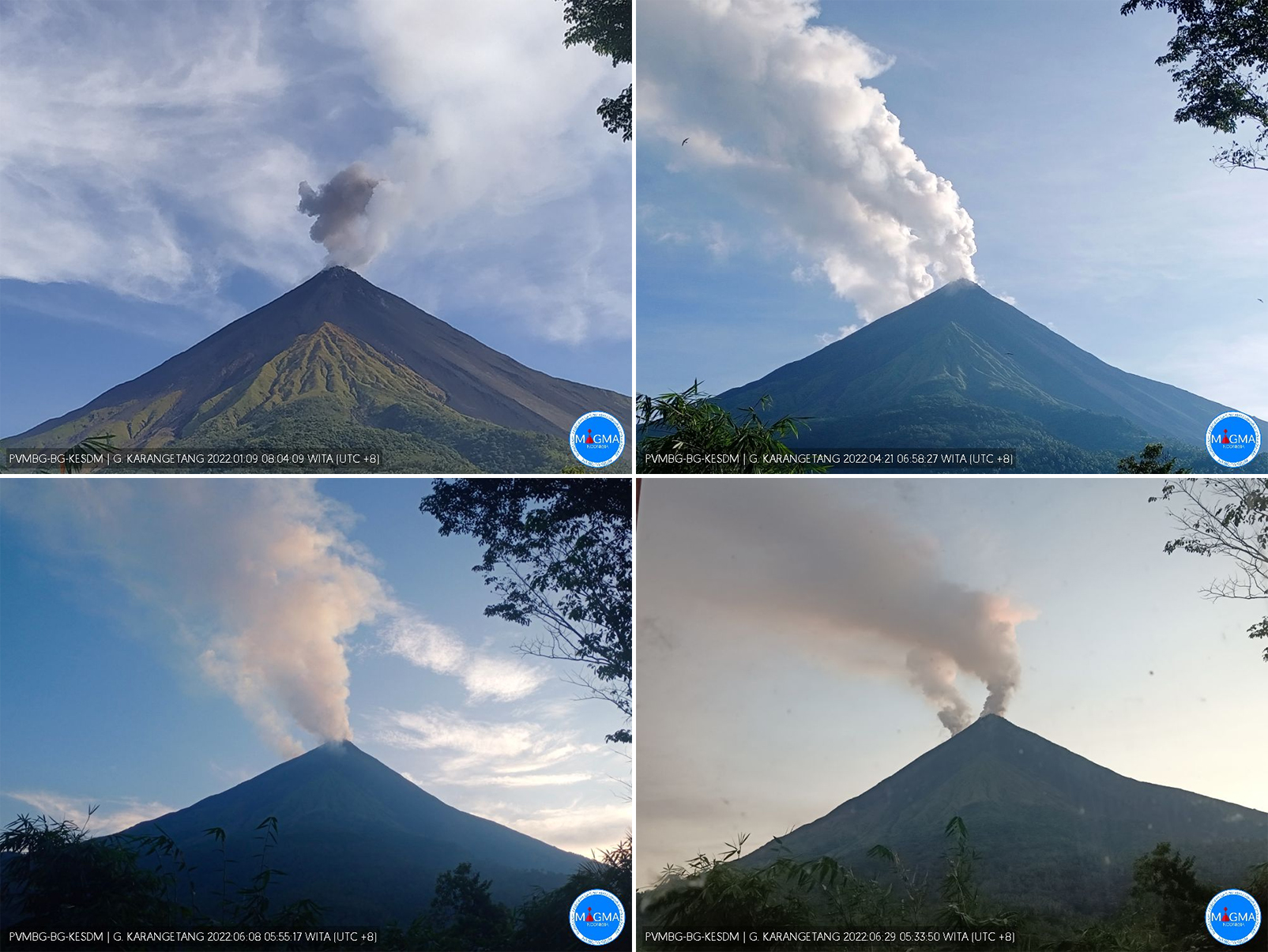 |
Figure 55. Webcam images of Karangetang showing white-to-gray plumes rising above both summit craters on 9 January 2022 (top left), 21 April 2022 (top right), 8 June 2022 (bottom left), and 29 June 2022 (bottom right). Courtesy of MAGMA Indonesia. |
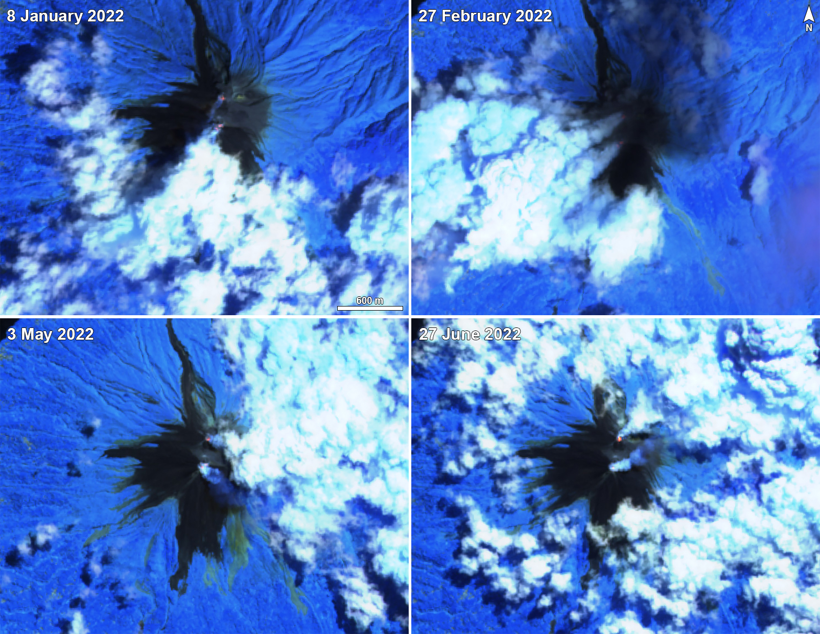 |
Figure 56. Small thermal anomalies (bright yellow-orange) at Karangetang were detected in the N and S summit craters on 8 January 2022 (top left), 27 February 2022 (top right), 3 May 2022 (bottom left), and 27 June 2022 (bottom right). Thermal anomalies from both craters were accompanied by gas-and-steam plumes that drifted in different directions. Images using “Atmospheric penetration” rendering (bands 12, 11, 8a). Courtesy of Sentinel Hub Playground. |
Information Contacts: Pusat Vulkanologi dan Mitigasi Bencana Geologi (PVMBG, also known as Indonesian Center for Volcanology and Geological Hazard Mitigation, CVGHM), Jalan Diponegoro 57, Bandung 40122, Indonesia (URL: http://www.vsi.esdm.go.id/); MAGMA Indonesia, Kementerian Energi dan Sumber Daya Mineral (URL: https://magma.esdm.go.id/v1); MIROVA (Middle InfraRed Observation of Volcanic Activity), a collaborative project between the Universities of Turin and Florence (Italy) supported by the Centre for Volcanic Risk of the Italian Civil Protection Department (URL: http://www.mirovaweb.it/); Sentinel Hub Playground (URL: https://www.sentinel-hub.com/explore/sentinel-playground).
Weak thermal activity and gas-and-steam emissions during July-December 2022
Karangetang (also known as Api Siau), at the northern end of the island of Siau, Indonesia, contains five summit craters along a N-S line. More than 40 eruptions have been recorded since 1675; twentieth-century eruptions have included frequent explosive activity, sometimes accompanied by pyroclastic flows and lahars. Lava dome growth has occurred in the summit craters and collapses of lava flow fronts have produced pyroclastic flows. The two active summit craters are Kawah Dua (the N crater) and Kawah Utama (the S crater, also referred to as the “Main Crater”). The most recent eruption began in late November 2018 and has more recently consisted of intermittent white-and-gray gas-and-steam plumes and summit crater incandescence (BGVN 47:07). This report covers activity during July through December 2022, characterized by crater incandescence and near daily white gas-and-steam emissions, based on reports from Pusat Vulkanologi dan Mitigasi Bencana Geologi (PVMBG, also known as CVGHM, or the Center of Volcanology and Geological Hazard Mitigation), MAGMA Indonesia, and satellite data.
Relatively low activity during the reporting period was mainly characterized by almost daily white, and less frequently gray, gas-and-steam emissions that rose 25-200 m above the summit (figure 57). Incandescence from the S crater on 9 November and from both the N and S craters on 14 November was visible in satellite images. MIROVA (Middle InfraRed Observation of Volcanic Activity) analysis of MODIS satellite data showed weak-to-moderate power thermal anomalies during August through mid-December 2022 (figure 58). There was only one small anomaly detected during early July. By later August, thermal activity began to increase in both frequency and power, which peaked during late September and then began to decline. Anomalies were then lower in power and less frequent during October through mid-December. A thermal anomaly was visible in Sentinel-2 infrared satellite imagery in the N summit crater throughout the reporting period, occasionally accompanied by gas-and-steam emissions (figure 59). A weaker anomaly was visible in the S summit crater at least on 17 July, 31 August, 15 September, 15 October, and 4 December.
|
Figure 57. Webcam images of Karangetang showing white-to-gray plumes rising above both summit craters on 31 August 2022 (top left), 22 September 2022 (top right), 20 October 2022 (bottom left), and 2 December 2022 (bottom right). Courtesy of MAGMA Indonesia. |
|
Figure 58. Weak-to-moderate power thermal anomalies were detected in the summit area of Karangetang during August through mid-December 2022 as recorded by this MIROVA graph (Log Radiative Power). Only a single low-power anomaly was detected during early July. There was a gradual increase in both power and frequency of anomalies during September, which then had declined by the end of the month. Courtesy of MIROVA. |
|
Figure 59. A small thermal anomaly (yellow-orange) was visible at the N summit crater at Karangetang on 17 July 2022 (top left), 31 August 2022 (top right), 15 September 2022 (middle left), 15 October 2022 (middle right), 29 November 2022 (bottom left), and 4 December 2022 (bottom right). A weaker anomaly was also detected in the S summit crater during these dates, except on 29 November due to cloud cover. Gas-and-steam emissions were occasionally observed from both summit craters. Images using “Atmospheric penetration” rendering (bands 12, 11, 8a). Courtesy of Sentinel Hub Playground. |
Information Contacts: Pusat Vulkanologi dan Mitigasi Bencana Geologi (PVMBG, also known as Indonesian Center for Volcanology and Geological Hazard Mitigation, CVGHM), Jalan Diponegoro 57, Bandung 40122, Indonesia (URL: http://www.vsi.esdm.go.id/); MAGMA Indonesia, Kementerian Energi dan Sumber Daya Mineral (URL: https://magma.esdm.go.id/v1); MIROVA (Middle InfraRed Observation of Volcanic Activity), a collaborative project between the Universities of Turin and Florence (Italy) supported by the Centre for Volcanic Risk of the Italian Civil Protection Department (URL: http://www.mirovaweb.it/); Sentinel Hub Playground (URL: https://www.sentinel-hub.com/explore/sentinel-playground).
This compilation of synonyms and subsidiary features may not be comprehensive. Features are organized into four major categories: Cones, Craters, Domes, and Thermal Features. Synonyms of features appear indented below the primary name. In some cases additional feature type, elevation, or location details are provided.
Synonyms |
| Api Siau | Awoeh |
|
|
||||||||||||||||||||||||
There is data available for 56 confirmed Holocene eruptive periods.
2018 Nov 25 - 2024 Mar 1 (continuing) Confirmed Eruption Max VEI: 2
| Episode 1 | Eruption Episode | |||||||||||||||||||||||||
|---|---|---|---|---|---|---|---|---|---|---|---|---|---|---|---|---|---|---|---|---|---|---|---|---|---|
| 2018 Nov 25 - 2024 Mar 1 (continuing) | Evidence from Observations: Reported | ||||||||||||||||||||||||
|
List of 3 Events for Episode 1
| |||||||||||||||||||||||||
2018 Feb 2 - 2018 Feb 2 Confirmed Eruption Max VEI: 1
| Episode 1 | Eruption Episode | |||||||||||||||
|---|---|---|---|---|---|---|---|---|---|---|---|---|---|---|---|
| 2018 Feb 2 - 2018 Feb 2 | Evidence from Observations: Reported | ||||||||||||||
|
List of 1 Events for Episode 1
| |||||||||||||||
[ 2017 May 10 - 2017 May 10 ] Uncertain Eruption
| Episode 1 | Uncertain Episode | |||||
|---|---|---|---|---|---|
| 2017 May 10 - 2017 May 10 | Evidence from Observations: Reported | ||||
| Based on analyses of satellite imagery, wind data, and ground-based visual observations, the Darwin VAAC reported that on 10 May 2017 a gas-and-steam plume, possibly containing ash, rose to an altitude of 3.6 km and drifted more than 35 km SE. | |||||
2014 Jun 8 - 2016 Mar 15 Confirmed Eruption Max VEI: 2
| Episode 1 | Eruption Episode | Main and second craters | |||||||||||||||||||||||||||||||||||||||||||||||||
|---|---|---|---|---|---|---|---|---|---|---|---|---|---|---|---|---|---|---|---|---|---|---|---|---|---|---|---|---|---|---|---|---|---|---|---|---|---|---|---|---|---|---|---|---|---|---|---|---|---|---|
| 2014 Jun 8 - 2014 Oct 20 | Evidence from Observations: Reported | |||||||||||||||||||||||||||||||||||||||||||||||||
|
List of 8 Events for Episode 1 at Main and second craters
| ||||||||||||||||||||||||||||||||||||||||||||||||||
| Episode 2 | Eruption Episode | Main crater | ||||||||||||||||||||||||||||||||||||||||||||||||||||||||||||||||||||||||||||||||||||||||||||||||||||||||||||||||||||||||||||||||||||||||||||||||||||||||||||||||||||||||||||||||||||||||||||||||||||||||||||||||||||||||||||||||||||||||||||||||||||||||||||||||||||||||||||||||||||||||||||||||||||||||||||||||||||||||||||||||||||||||||||||||||||||||||||||||||||||||||||||||||||||||||||||||||||||||||
|---|---|---|---|---|---|---|---|---|---|---|---|---|---|---|---|---|---|---|---|---|---|---|---|---|---|---|---|---|---|---|---|---|---|---|---|---|---|---|---|---|---|---|---|---|---|---|---|---|---|---|---|---|---|---|---|---|---|---|---|---|---|---|---|---|---|---|---|---|---|---|---|---|---|---|---|---|---|---|---|---|---|---|---|---|---|---|---|---|---|---|---|---|---|---|---|---|---|---|---|---|---|---|---|---|---|---|---|---|---|---|---|---|---|---|---|---|---|---|---|---|---|---|---|---|---|---|---|---|---|---|---|---|---|---|---|---|---|---|---|---|---|---|---|---|---|---|---|---|---|---|---|---|---|---|---|---|---|---|---|---|---|---|---|---|---|---|---|---|---|---|---|---|---|---|---|---|---|---|---|---|---|---|---|---|---|---|---|---|---|---|---|---|---|---|---|---|---|---|---|---|---|---|---|---|---|---|---|---|---|---|---|---|---|---|---|---|---|---|---|---|---|---|---|---|---|---|---|---|---|---|---|---|---|---|---|---|---|---|---|---|---|---|---|---|---|---|---|---|---|---|---|---|---|---|---|---|---|---|---|---|---|---|---|---|---|---|---|---|---|---|---|---|---|---|---|---|---|---|---|---|---|---|---|---|---|---|---|---|---|---|---|---|---|---|---|---|---|---|---|---|---|---|---|---|---|---|---|---|---|---|---|---|---|---|---|---|---|---|---|---|---|---|---|---|---|---|---|---|---|---|---|---|---|---|---|---|---|---|---|---|---|---|---|---|---|---|---|---|---|---|---|---|---|---|---|---|---|---|---|---|---|---|---|---|---|---|---|---|---|---|---|---|---|---|---|---|---|---|---|---|---|---|---|---|---|---|---|---|---|---|---|---|---|---|---|
| 2015 Jan 12 - 2016 Mar 15 | Evidence from Observations: Reported | ||||||||||||||||||||||||||||||||||||||||||||||||||||||||||||||||||||||||||||||||||||||||||||||||||||||||||||||||||||||||||||||||||||||||||||||||||||||||||||||||||||||||||||||||||||||||||||||||||||||||||||||||||||||||||||||||||||||||||||||||||||||||||||||||||||||||||||||||||||||||||||||||||||||||||||||||||||||||||||||||||||||||||||||||||||||||||||||||||||||||||||||||||||||||||||||||||||||||||
|
List of 77 Events for Episode 2 at Main crater
| |||||||||||||||||||||||||||||||||||||||||||||||||||||||||||||||||||||||||||||||||||||||||||||||||||||||||||||||||||||||||||||||||||||||||||||||||||||||||||||||||||||||||||||||||||||||||||||||||||||||||||||||||||||||||||||||||||||||||||||||||||||||||||||||||||||||||||||||||||||||||||||||||||||||||||||||||||||||||||||||||||||||||||||||||||||||||||||||||||||||||||||||||||||||||||||||||||||||||||
2014 Feb 9 - 2014 Feb 9 Confirmed Eruption Max VEI: 2
| Episode 1 | Eruption Episode | ||||||||||||||||||||
|---|---|---|---|---|---|---|---|---|---|---|---|---|---|---|---|---|---|---|---|---|
| 2014 Feb 9 - 2014 Feb 9 | Evidence from Observations: Reported | |||||||||||||||||||
|
List of 2 Events for Episode 1
| ||||||||||||||||||||
2012 May 14 - 2013 Sep 5 Confirmed Eruption Max VEI: 2
| Episode 1 | Eruption Episode | Crater II | ||||||||||||||||||||||||||||||||||||||||||||||||||||||||||||||||||||||||||||||||||||||||||||||||||||||||||||||||||||||||||||||||||||||||||||||||||||||||||||||||||||
|---|---|---|---|---|---|---|---|---|---|---|---|---|---|---|---|---|---|---|---|---|---|---|---|---|---|---|---|---|---|---|---|---|---|---|---|---|---|---|---|---|---|---|---|---|---|---|---|---|---|---|---|---|---|---|---|---|---|---|---|---|---|---|---|---|---|---|---|---|---|---|---|---|---|---|---|---|---|---|---|---|---|---|---|---|---|---|---|---|---|---|---|---|---|---|---|---|---|---|---|---|---|---|---|---|---|---|---|---|---|---|---|---|---|---|---|---|---|---|---|---|---|---|---|---|---|---|---|---|---|---|---|---|---|---|---|---|---|---|---|---|---|---|---|---|---|---|---|---|---|---|---|---|---|---|---|---|---|---|---|---|---|---|---|---|---|
| 2012 May 14 - 2013 Sep 5 | Evidence from Observations: Reported | ||||||||||||||||||||||||||||||||||||||||||||||||||||||||||||||||||||||||||||||||||||||||||||||||||||||||||||||||||||||||||||||||||||||||||||||||||||||||||||||||||||
|
List of 31 Events for Episode 1 at Crater II
| |||||||||||||||||||||||||||||||||||||||||||||||||||||||||||||||||||||||||||||||||||||||||||||||||||||||||||||||||||||||||||||||||||||||||||||||||||||||||||||||||||||
2011 Mar 11 - 2011 Aug 13 Confirmed Eruption Max VEI: 2
| Episode 1 | Eruption Episode | Crater I (S crater) | ||||||||||||||||||||||||||||||||||||||||||||||||||||||||||||||||||||||||||||||||||||||||||||||||||||||||||||||||||||||||||||||||||||||||||||||||||||||||||||||||||||||||||||||||||||||||||||||||||||||||||||
|---|---|---|---|---|---|---|---|---|---|---|---|---|---|---|---|---|---|---|---|---|---|---|---|---|---|---|---|---|---|---|---|---|---|---|---|---|---|---|---|---|---|---|---|---|---|---|---|---|---|---|---|---|---|---|---|---|---|---|---|---|---|---|---|---|---|---|---|---|---|---|---|---|---|---|---|---|---|---|---|---|---|---|---|---|---|---|---|---|---|---|---|---|---|---|---|---|---|---|---|---|---|---|---|---|---|---|---|---|---|---|---|---|---|---|---|---|---|---|---|---|---|---|---|---|---|---|---|---|---|---|---|---|---|---|---|---|---|---|---|---|---|---|---|---|---|---|---|---|---|---|---|---|---|---|---|---|---|---|---|---|---|---|---|---|---|---|---|---|---|---|---|---|---|---|---|---|---|---|---|---|---|---|---|---|---|---|---|---|---|---|---|---|---|---|---|---|---|---|---|---|---|---|---|---|---|
| 2011 Mar 11 - 2011 Aug 13 | Evidence from Observations: Reported | ||||||||||||||||||||||||||||||||||||||||||||||||||||||||||||||||||||||||||||||||||||||||||||||||||||||||||||||||||||||||||||||||||||||||||||||||||||||||||||||||||||||||||||||||||||||||||||||||||||||||||||
|
List of 39 Events for Episode 1 at Crater I (S crater)
| |||||||||||||||||||||||||||||||||||||||||||||||||||||||||||||||||||||||||||||||||||||||||||||||||||||||||||||||||||||||||||||||||||||||||||||||||||||||||||||||||||||||||||||||||||||||||||||||||||||||||||||
2010 Aug 6 - 2010 Dec 16 (?) ± 15 days Confirmed Eruption Max VEI: 3 (?)
| Episode 1 | Eruption Episode | Crater I (S crater) | ||||||||||||||||||||||||||||||||||||||||||||||||||||||||||||||||||||||||||||||||||||||||||||||||||||||||||||||||||||||||||||
|---|---|---|---|---|---|---|---|---|---|---|---|---|---|---|---|---|---|---|---|---|---|---|---|---|---|---|---|---|---|---|---|---|---|---|---|---|---|---|---|---|---|---|---|---|---|---|---|---|---|---|---|---|---|---|---|---|---|---|---|---|---|---|---|---|---|---|---|---|---|---|---|---|---|---|---|---|---|---|---|---|---|---|---|---|---|---|---|---|---|---|---|---|---|---|---|---|---|---|---|---|---|---|---|---|---|---|---|---|---|---|---|---|---|---|---|---|---|---|---|---|---|---|---|---|---|
| 2010 Aug 6 - 2010 Dec 16 (?) ± 15 days | Evidence from Observations: Reported | ||||||||||||||||||||||||||||||||||||||||||||||||||||||||||||||||||||||||||||||||||||||||||||||||||||||||||||||||||||||||||||
|
List of 23 Events for Episode 1 at Crater I (S crater)
| |||||||||||||||||||||||||||||||||||||||||||||||||||||||||||||||||||||||||||||||||||||||||||||||||||||||||||||||||||||||||||||
2008 Nov 29 (?) - 2010 Mar 24 (?) Confirmed Eruption Max VEI: 2
| Episode 1 | Eruption Episode | ||||||||||||||||||||||||||||||||||||||||||||||||||||||||||||
|---|---|---|---|---|---|---|---|---|---|---|---|---|---|---|---|---|---|---|---|---|---|---|---|---|---|---|---|---|---|---|---|---|---|---|---|---|---|---|---|---|---|---|---|---|---|---|---|---|---|---|---|---|---|---|---|---|---|---|---|---|
| 2008 Nov 29 (?) - 2010 Mar 24 (?) | Evidence from Observations: Reported | |||||||||||||||||||||||||||||||||||||||||||||||||||||||||||
|
List of 10 Events for Episode 1
| ||||||||||||||||||||||||||||||||||||||||||||||||||||||||||||
[ 2008 Mar 12 - 2008 Mar 12 ] Uncertain Eruption
| Episode 1 | Uncertain Episode | |||||||||||||||||||||||||
|---|---|---|---|---|---|---|---|---|---|---|---|---|---|---|---|---|---|---|---|---|---|---|---|---|---|
| 2008 Mar 12 - 2008 Mar 12 | Evidence from Observations: Aviation | ||||||||||||||||||||||||
| Based on a pilot observation, the Darwin VAAC reported a possible low-level ash plume on 12 March 2008. | |||||||||||||||||||||||||
|
List of 3 Events for Episode 1
| |||||||||||||||||||||||||
2006 Jul 3 - 2007 Oct 16 (in or after) ± 15 days Confirmed Eruption Max VEI: 1
| Episode 1 | Eruption Episode | |||||||||||||||||||||||||||||||||||||||||||||||||||||||||||||||||
|---|---|---|---|---|---|---|---|---|---|---|---|---|---|---|---|---|---|---|---|---|---|---|---|---|---|---|---|---|---|---|---|---|---|---|---|---|---|---|---|---|---|---|---|---|---|---|---|---|---|---|---|---|---|---|---|---|---|---|---|---|---|---|---|---|---|
| 2006 Jul 3 - 2007 Oct 16 (in or after) ± 15 days | Evidence from Observations: Reported | ||||||||||||||||||||||||||||||||||||||||||||||||||||||||||||||||
|
List of 11 Events for Episode 1
| |||||||||||||||||||||||||||||||||||||||||||||||||||||||||||||||||
2004 Apr 2 (?) - 2005 Aug 5 (?) Confirmed Eruption Max VEI: 2
| Episode 1 | Eruption Episode | |||||||||||||||||||||||||||||||||||
|---|---|---|---|---|---|---|---|---|---|---|---|---|---|---|---|---|---|---|---|---|---|---|---|---|---|---|---|---|---|---|---|---|---|---|---|
| 2004 Apr 2 (?) - 2005 Aug 5 (?) | Evidence from Observations: Reported | ||||||||||||||||||||||||||||||||||
|
List of 5 Events for Episode 1
| |||||||||||||||||||||||||||||||||||
1999 Mar 16 (in or before) ± 15 days - 2003 Oct 28 Confirmed Eruption Max VEI: 3 (?)
| Episode 1 | Eruption Episode | |||||||||||||||||||||||||||||||||||||||||||||||||||||||||||||||||||||||||||
|---|---|---|---|---|---|---|---|---|---|---|---|---|---|---|---|---|---|---|---|---|---|---|---|---|---|---|---|---|---|---|---|---|---|---|---|---|---|---|---|---|---|---|---|---|---|---|---|---|---|---|---|---|---|---|---|---|---|---|---|---|---|---|---|---|---|---|---|---|---|---|---|---|---|---|---|
| 1999 Mar 16 (in or before) ± 15 days - 2003 Oct 28 | Evidence from Observations: Reported | ||||||||||||||||||||||||||||||||||||||||||||||||||||||||||||||||||||||||||
|
List of 13 Events for Episode 1
| |||||||||||||||||||||||||||||||||||||||||||||||||||||||||||||||||||||||||||
1998 Jul 5 ± 4 days Confirmed Eruption Max VEI: 1
| Episode 1 | Eruption Episode | |||||||||||||||||||||||||
|---|---|---|---|---|---|---|---|---|---|---|---|---|---|---|---|---|---|---|---|---|---|---|---|---|---|
| 1998 Jul 5 ± 4 days - Unknown | Evidence from Observations: Reported | ||||||||||||||||||||||||
|
List of 3 Events for Episode 1
| |||||||||||||||||||||||||
1996 Oct 1 (in or before) - 1997 Jun 16 (in or after) ± 15 days Confirmed Eruption Max VEI: 1
| Episode 1 | Eruption Episode | ||||||||||||||||||||||||||||||||||||||||
|---|---|---|---|---|---|---|---|---|---|---|---|---|---|---|---|---|---|---|---|---|---|---|---|---|---|---|---|---|---|---|---|---|---|---|---|---|---|---|---|---|
| 1996 Oct 1 (in or before) - 1997 Jun 16 (in or after) ± 15 days | Evidence from Observations: Reported | |||||||||||||||||||||||||||||||||||||||
|
List of 6 Events for Episode 1
| ||||||||||||||||||||||||||||||||||||||||
1995 Nov 9 - 1995 Dec 17 Confirmed Eruption Max VEI: 1
| Episode 1 | Eruption Episode | ||||||||||||||||||||||||||||||
|---|---|---|---|---|---|---|---|---|---|---|---|---|---|---|---|---|---|---|---|---|---|---|---|---|---|---|---|---|---|---|
| 1995 Nov 9 - 1995 Dec 17 | Evidence from Observations: Reported | |||||||||||||||||||||||||||||
|
List of 4 Events for Episode 1
| ||||||||||||||||||||||||||||||
1991 Jul 2 (in or before) - 1993 Dec 31 (in or after) Confirmed Eruption Max VEI: 2
| Episode 1 | Eruption Episode | ||||||||||||||||||||||||||||||||||||||||||||||||||||||||||||||||||||||
|---|---|---|---|---|---|---|---|---|---|---|---|---|---|---|---|---|---|---|---|---|---|---|---|---|---|---|---|---|---|---|---|---|---|---|---|---|---|---|---|---|---|---|---|---|---|---|---|---|---|---|---|---|---|---|---|---|---|---|---|---|---|---|---|---|---|---|---|---|---|---|
| 1991 Jul 2 (in or before) - 1993 Dec 31 (in or after) | Evidence from Observations: Reported | |||||||||||||||||||||||||||||||||||||||||||||||||||||||||||||||||||||
|
List of 12 Events for Episode 1
| ||||||||||||||||||||||||||||||||||||||||||||||||||||||||||||||||||||||
1989 Jul 16 ± 15 days - 1989 Jul 16 ± 15 days Confirmed Eruption Max VEI: 1
| Episode 1 | Eruption Episode | |||||||||||||||||||||||||
|---|---|---|---|---|---|---|---|---|---|---|---|---|---|---|---|---|---|---|---|---|---|---|---|---|---|
| 1989 Jul 16 ± 15 days - 1989 Jul 16 ± 15 days | Evidence from Observations: Reported | ||||||||||||||||||||||||
|
List of 3 Events for Episode 1
| |||||||||||||||||||||||||
1983 May 16 ± 15 days - 1988 Dec 31 (in or after) Confirmed Eruption Max VEI: 3
| Episode 1 | Eruption Episode | Summit and SW flank (1443 m) | ||||||||||||||||||||||||||||||||||||||||||||||||||||||||||||||||||||||||||
|---|---|---|---|---|---|---|---|---|---|---|---|---|---|---|---|---|---|---|---|---|---|---|---|---|---|---|---|---|---|---|---|---|---|---|---|---|---|---|---|---|---|---|---|---|---|---|---|---|---|---|---|---|---|---|---|---|---|---|---|---|---|---|---|---|---|---|---|---|---|---|---|---|---|---|---|
| 1983 May 16 ± 15 days - 1988 Dec 31 (in or after) | Evidence from Observations: Reported | ||||||||||||||||||||||||||||||||||||||||||||||||||||||||||||||||||||||||||
|
List of 13 Events for Episode 1 at Summit and SW flank (1443 m)
| |||||||||||||||||||||||||||||||||||||||||||||||||||||||||||||||||||||||||||
1982 Jul 2 ± 182 days Confirmed Eruption Max VEI: 1
| Episode 1 | Eruption Episode | ||||||||||||||||||||
|---|---|---|---|---|---|---|---|---|---|---|---|---|---|---|---|---|---|---|---|---|
| 1982 Jul 2 ± 182 days - Unknown | Evidence from Observations: Reported | |||||||||||||||||||
|
List of 2 Events for Episode 1
| ||||||||||||||||||||
1980 Mar 24 - 1980 Sep 13 Confirmed Eruption Max VEI: 1
| Episode 1 | Eruption Episode | |||||||||||||||||||||||||
|---|---|---|---|---|---|---|---|---|---|---|---|---|---|---|---|---|---|---|---|---|---|---|---|---|---|
| 1980 Mar 24 - 1980 Sep 13 | Evidence from Observations: Reported | ||||||||||||||||||||||||
|
List of 3 Events for Episode 1
| |||||||||||||||||||||||||
1979 May 31 - 1979 May 31 Confirmed Eruption Max VEI: 1
| Episode 1 | Eruption Episode | NNW flank, 1300 m (Kawah Maralebule) | ||||||||||||||||||||||||
|---|---|---|---|---|---|---|---|---|---|---|---|---|---|---|---|---|---|---|---|---|---|---|---|---|---|
| 1979 May 31 - 1979 May 31 | Evidence from Observations: Reported | ||||||||||||||||||||||||
|
List of 3 Events for Episode 1 at NNW flank, 1300 m (Kawah Maralebule)
| |||||||||||||||||||||||||
1978 Feb 22 - 1978 Dec 18 Confirmed Eruption Max VEI: 1
| Episode 1 | Eruption Episode | ||||||||||||||||||||||||||||||
|---|---|---|---|---|---|---|---|---|---|---|---|---|---|---|---|---|---|---|---|---|---|---|---|---|---|---|---|---|---|---|
| 1978 Feb 22 - 1978 Dec 18 | Evidence from Observations: Reported | |||||||||||||||||||||||||||||
|
List of 4 Events for Episode 1
| ||||||||||||||||||||||||||||||
1976 Sep 15 - 1977 Sep 16 ± 15 days Confirmed Eruption Max VEI: 2
| Episode 1 | Eruption Episode | South flank (1100 m) and summit | |||||||||||||||||||||||||||||||||||||||||||||||||||||||||||||||||||||
|---|---|---|---|---|---|---|---|---|---|---|---|---|---|---|---|---|---|---|---|---|---|---|---|---|---|---|---|---|---|---|---|---|---|---|---|---|---|---|---|---|---|---|---|---|---|---|---|---|---|---|---|---|---|---|---|---|---|---|---|---|---|---|---|---|---|---|---|---|---|---|
| 1976 Sep 15 - 1977 Sep 16 ± 15 days | Evidence from Observations: Reported | |||||||||||||||||||||||||||||||||||||||||||||||||||||||||||||||||||||
|
List of 12 Events for Episode 1 at South flank (1100 m) and summit
| ||||||||||||||||||||||||||||||||||||||||||||||||||||||||||||||||||||||
1972 Jan 16 ± 15 days - 1976 Apr 5 Confirmed Eruption Max VEI: 3
| Episode 1 | Eruption Episode | |||||||||||||||||||||||||||||||||||||||||||||||||||||||||||||||||||||||||||||||||||||
|---|---|---|---|---|---|---|---|---|---|---|---|---|---|---|---|---|---|---|---|---|---|---|---|---|---|---|---|---|---|---|---|---|---|---|---|---|---|---|---|---|---|---|---|---|---|---|---|---|---|---|---|---|---|---|---|---|---|---|---|---|---|---|---|---|---|---|---|---|---|---|---|---|---|---|---|---|---|---|---|---|---|---|---|---|---|
| 1972 Jan 16 ± 15 days - 1976 Apr 5 | Evidence from Observations: Reported | ||||||||||||||||||||||||||||||||||||||||||||||||||||||||||||||||||||||||||||||||||||
|
List of 15 Events for Episode 1
| |||||||||||||||||||||||||||||||||||||||||||||||||||||||||||||||||||||||||||||||||||||
1970 Nov 27 - 1971 Mar 16 ± 15 days Confirmed Eruption Max VEI: 2
| Episode 1 | Eruption Episode | ||||||||||||||||||||||||||||||||||||||||||||||||||||||||||||
|---|---|---|---|---|---|---|---|---|---|---|---|---|---|---|---|---|---|---|---|---|---|---|---|---|---|---|---|---|---|---|---|---|---|---|---|---|---|---|---|---|---|---|---|---|---|---|---|---|---|---|---|---|---|---|---|---|---|---|---|---|
| 1970 Nov 27 - 1971 Mar 16 ± 15 days | Evidence from Observations: Reported | |||||||||||||||||||||||||||||||||||||||||||||||||||||||||||
|
List of 10 Events for Episode 1
| ||||||||||||||||||||||||||||||||||||||||||||||||||||||||||||
1967 Nov 29 - 1967 Dec 2 Confirmed Eruption Max VEI: 2
| Episode 1 | Eruption Episode | ||||||||||||||||||||
|---|---|---|---|---|---|---|---|---|---|---|---|---|---|---|---|---|---|---|---|---|
| 1967 Nov 29 - 1967 Dec 2 | Evidence from Observations: Reported | |||||||||||||||||||
|
List of 2 Events for Episode 1
| ||||||||||||||||||||
1965 Apr 5 ± 4 days - 1967 Jun 16 ± 15 days Confirmed Eruption Max VEI: 2
| Episode 1 | Eruption Episode | |||||||||||||||||||||||||||||||||||||||||||||
|---|---|---|---|---|---|---|---|---|---|---|---|---|---|---|---|---|---|---|---|---|---|---|---|---|---|---|---|---|---|---|---|---|---|---|---|---|---|---|---|---|---|---|---|---|---|
| 1965 Apr 5 ± 4 days - 1967 Jun 16 ± 15 days | Evidence from Observations: Reported | ||||||||||||||||||||||||||||||||||||||||||||
|
List of 7 Events for Episode 1
| |||||||||||||||||||||||||||||||||||||||||||||
1962 Jan 29 - 1963 Dec 16 ± 15 days Confirmed Eruption Max VEI: 2
| Episode 1 | Eruption Episode | |||||||||||||||||||||||||||||||||||||||||||||
|---|---|---|---|---|---|---|---|---|---|---|---|---|---|---|---|---|---|---|---|---|---|---|---|---|---|---|---|---|---|---|---|---|---|---|---|---|---|---|---|---|---|---|---|---|---|
| 1962 Jan 29 - 1963 Dec 16 ± 15 days | Evidence from Observations: Reported | ||||||||||||||||||||||||||||||||||||||||||||
|
List of 7 Events for Episode 1
| |||||||||||||||||||||||||||||||||||||||||||||
1961 Oct 9 - 1961 Oct 19 (in or after) Confirmed Eruption Max VEI: 2
| Episode 1 | Eruption Episode | |||||||||||||||||||||||||||||||||||||||||||||
|---|---|---|---|---|---|---|---|---|---|---|---|---|---|---|---|---|---|---|---|---|---|---|---|---|---|---|---|---|---|---|---|---|---|---|---|---|---|---|---|---|---|---|---|---|---|
| 1961 Oct 9 - 1961 Oct 19 (in or after) | Evidence from Observations: Reported | ||||||||||||||||||||||||||||||||||||||||||||
|
List of 7 Events for Episode 1
| |||||||||||||||||||||||||||||||||||||||||||||
1961 Feb 28 - 1961 Apr 16 ± 15 days Confirmed Eruption Max VEI: 2
| Episode 1 | Eruption Episode | ||||||||||||||||||||
|---|---|---|---|---|---|---|---|---|---|---|---|---|---|---|---|---|---|---|---|---|
| 1961 Feb 28 - 1961 Apr 16 ± 15 days | Evidence from Observations: Reported | |||||||||||||||||||
|
List of 2 Events for Episode 1
| ||||||||||||||||||||
1953 Jul 2 ± 182 days Confirmed Eruption Max VEI: 2
| Episode 1 | Eruption Episode | ||||||||||||||||||||
|---|---|---|---|---|---|---|---|---|---|---|---|---|---|---|---|---|---|---|---|---|
| 1953 Jul 2 ± 182 days - Unknown | Evidence from Observations: Reported | |||||||||||||||||||
|
List of 2 Events for Episode 1
| ||||||||||||||||||||
1952 Feb 16 ± 15 days - 1952 Jun 30 Confirmed Eruption Max VEI: 2
| Episode 1 | Eruption Episode | Craters I, II and III | ||||||||||||||||||||||||||||||||||||||||||||
|---|---|---|---|---|---|---|---|---|---|---|---|---|---|---|---|---|---|---|---|---|---|---|---|---|---|---|---|---|---|---|---|---|---|---|---|---|---|---|---|---|---|---|---|---|---|
| 1952 Feb 16 ± 15 days - 1952 Jun 30 | Evidence from Observations: Reported | ||||||||||||||||||||||||||||||||||||||||||||
|
List of 7 Events for Episode 1 at Craters I, II and III
| |||||||||||||||||||||||||||||||||||||||||||||
1949 Sep 14 Confirmed Eruption Max VEI: 2
| Episode 1 | Eruption Episode | ||||||||||||||||||||||||||||||
|---|---|---|---|---|---|---|---|---|---|---|---|---|---|---|---|---|---|---|---|---|---|---|---|---|---|---|---|---|---|---|
| 1949 Sep 14 - Unknown | Evidence from Observations: Reported | |||||||||||||||||||||||||||||
|
List of 4 Events for Episode 1
| ||||||||||||||||||||||||||||||
1948 Dec Confirmed Eruption Max VEI: 2
| Episode 1 | Eruption Episode | ||||||||||||||||||||
|---|---|---|---|---|---|---|---|---|---|---|---|---|---|---|---|---|---|---|---|---|
| 1948 Dec - Unknown | Evidence from Observations: Reported | |||||||||||||||||||
|
List of 2 Events for Episode 1
| ||||||||||||||||||||
1947 Dec 1 - 1947 Dec 21 Confirmed Eruption Max VEI: 2
| Episode 1 | Eruption Episode | ||||||||||||||||||||
|---|---|---|---|---|---|---|---|---|---|---|---|---|---|---|---|---|---|---|---|---|
| 1947 Dec 1 - 1947 Dec 21 | Evidence from Observations: Reported | |||||||||||||||||||
|
List of 2 Events for Episode 1
| ||||||||||||||||||||
1947 Feb 9 - 1947 Feb 9 Confirmed Eruption Max VEI: 2
| Episode 1 | Eruption Episode | ||||||||||||||||||||
|---|---|---|---|---|---|---|---|---|---|---|---|---|---|---|---|---|---|---|---|---|
| 1947 Feb 9 - 1947 Feb 9 | Evidence from Observations: Reported | |||||||||||||||||||
|
List of 2 Events for Episode 1
| ||||||||||||||||||||
1941 Oct 30 - 1941 Oct 30 Confirmed Eruption Max VEI: 2
| Episode 1 | Eruption Episode | |||||||||||||||||||||||||||||||||||||||||||||||||||||||
|---|---|---|---|---|---|---|---|---|---|---|---|---|---|---|---|---|---|---|---|---|---|---|---|---|---|---|---|---|---|---|---|---|---|---|---|---|---|---|---|---|---|---|---|---|---|---|---|---|---|---|---|---|---|---|---|
| 1941 Oct 30 - 1941 Oct 30 | Evidence from Observations: Reported | ||||||||||||||||||||||||||||||||||||||||||||||||||||||
|
List of 9 Events for Episode 1
| |||||||||||||||||||||||||||||||||||||||||||||||||||||||
1940 Jun 20 - 1940 Aug 23 Confirmed Eruption Max VEI: 2
| Episode 1 | Eruption Episode | ||||||||||||||||||||||||||||||
|---|---|---|---|---|---|---|---|---|---|---|---|---|---|---|---|---|---|---|---|---|---|---|---|---|---|---|---|---|---|---|
| 1940 Jun 20 - 1940 Aug 23 | Evidence from Observations: Reported | |||||||||||||||||||||||||||||
|
List of 4 Events for Episode 1
| ||||||||||||||||||||||||||||||
1940 Mar 1 - 1940 Mar 9 Confirmed Eruption Max VEI: 2
| Episode 1 | Eruption Episode | ||||||||||||||||||||
|---|---|---|---|---|---|---|---|---|---|---|---|---|---|---|---|---|---|---|---|---|
| 1940 Mar 1 - 1940 Mar 9 | Evidence from Observations: Reported | |||||||||||||||||||
|
List of 2 Events for Episode 1
| ||||||||||||||||||||
1935 Aug 31 Confirmed Eruption Max VEI: 2
| Episode 1 | Eruption Episode | ||||||||||||||||||||
|---|---|---|---|---|---|---|---|---|---|---|---|---|---|---|---|---|---|---|---|---|
| 1935 Aug 31 - Unknown | Evidence from Observations: Reported | |||||||||||||||||||
|
List of 2 Events for Episode 1
| ||||||||||||||||||||
1930 Nov (?) Confirmed Eruption Max VEI: 2
| Episode 1 | Eruption Episode | ||||||||||||||||||||
|---|---|---|---|---|---|---|---|---|---|---|---|---|---|---|---|---|---|---|---|---|
| 1930 Nov (?) - Unknown | Evidence from Observations: Reported | |||||||||||||||||||
|
List of 2 Events for Episode 1
| ||||||||||||||||||||
1930 Feb 4 - 1930 Feb 6 Confirmed Eruption Max VEI: 2
| Episode 1 | Eruption Episode | Crater IV | ||||||||||||||||||||||||||||||||||
|---|---|---|---|---|---|---|---|---|---|---|---|---|---|---|---|---|---|---|---|---|---|---|---|---|---|---|---|---|---|---|---|---|---|---|---|
| 1930 Feb 4 - 1930 Feb 6 | Evidence from Observations: Reported | ||||||||||||||||||||||||||||||||||
|
List of 5 Events for Episode 1 at Crater IV
| |||||||||||||||||||||||||||||||||||
1926 Oct Confirmed Eruption Max VEI: 2
| Episode 1 | Eruption Episode | ||||||||||||||||||||
|---|---|---|---|---|---|---|---|---|---|---|---|---|---|---|---|---|---|---|---|---|
| 1926 Oct - Unknown | Evidence from Observations: Reported | |||||||||||||||||||
|
List of 2 Events for Episode 1
| ||||||||||||||||||||
1924 May Confirmed Eruption Max VEI: 2
| Episode 1 | Eruption Episode | ||||||||||||||||||||
|---|---|---|---|---|---|---|---|---|---|---|---|---|---|---|---|---|---|---|---|---|
| 1924 May - Unknown | Evidence from Observations: Reported | |||||||||||||||||||
|
List of 2 Events for Episode 1
| ||||||||||||||||||||
1922 May 4 - 1922 Dec 13 Confirmed Eruption Max VEI: 2
| Episode 1 | Eruption Episode | Crater IV | ||||||||||||||||||||||||||||||||||
|---|---|---|---|---|---|---|---|---|---|---|---|---|---|---|---|---|---|---|---|---|---|---|---|---|---|---|---|---|---|---|---|---|---|---|---|
| 1922 May 4 - 1922 Dec 13 | Evidence from Observations: Reported | ||||||||||||||||||||||||||||||||||
|
List of 5 Events for Episode 1 at Crater IV
| |||||||||||||||||||||||||||||||||||
1921 Mar - 1921 Jun (in or after) Confirmed Eruption Max VEI: 2
| Episode 1 | Eruption Episode | Crater V | |||||||||||||||||||||||||||||
|---|---|---|---|---|---|---|---|---|---|---|---|---|---|---|---|---|---|---|---|---|---|---|---|---|---|---|---|---|---|---|
| 1921 Mar - 1921 Jun (in or after) | Evidence from Observations: Reported | |||||||||||||||||||||||||||||
|
List of 4 Events for Episode 1 at Crater V
| ||||||||||||||||||||||||||||||
1905 May 21 - 1905 May 22 Confirmed Eruption Max VEI: 2
| Episode 1 | Eruption Episode | |||||||||||||||||||||||||
|---|---|---|---|---|---|---|---|---|---|---|---|---|---|---|---|---|---|---|---|---|---|---|---|---|---|
| 1905 May 21 - 1905 May 22 | Evidence from Observations: Reported | ||||||||||||||||||||||||
|
List of 3 Events for Episode 1
| |||||||||||||||||||||||||
1900 Confirmed Eruption Max VEI: 2
| Episode 1 | Eruption Episode | ||||||||||||||||||||
|---|---|---|---|---|---|---|---|---|---|---|---|---|---|---|---|---|---|---|---|---|
| 1900 - Unknown | Evidence from Observations: Reported | |||||||||||||||||||
|
List of 2 Events for Episode 1
| ||||||||||||||||||||
1899 Confirmed Eruption Max VEI: 2
| Episode 1 | Eruption Episode | ||||||||||||||||||||
|---|---|---|---|---|---|---|---|---|---|---|---|---|---|---|---|---|---|---|---|---|
| 1899 - Unknown | Evidence from Observations: Reported | |||||||||||||||||||
|
List of 2 Events for Episode 1
| ||||||||||||||||||||
1892 Jun 14 (?) Confirmed Eruption Max VEI: 2
| Episode 1 | Eruption Episode | ||||||||||||||||||||||||||||||
|---|---|---|---|---|---|---|---|---|---|---|---|---|---|---|---|---|---|---|---|---|---|---|---|---|---|---|---|---|---|---|
| 1892 Jun 14 (?) - Unknown | Evidence from Observations: Reported | |||||||||||||||||||||||||||||
|
List of 4 Events for Episode 1
| ||||||||||||||||||||||||||||||
1887 May 27 - 1887 May 27 Confirmed Eruption Max VEI: 2
| Episode 1 | Eruption Episode | ||||||||||||||||||||
|---|---|---|---|---|---|---|---|---|---|---|---|---|---|---|---|---|---|---|---|---|
| 1887 May 27 - 1887 May 27 | Evidence from Observations: Reported | |||||||||||||||||||
|
List of 2 Events for Episode 1
| ||||||||||||||||||||
1886 Apr 25 - 1886 Jun 19 (in or after) Confirmed Eruption Max VEI: 2
| Episode 1 | Eruption Episode | Crater III | |||||||||||||||||||
|---|---|---|---|---|---|---|---|---|---|---|---|---|---|---|---|---|---|---|---|---|
| 1886 Apr 25 - 1886 Jun 19 (in or after) | Evidence from Observations: Reported | |||||||||||||||||||
|
List of 2 Events for Episode 1 at Crater III
| ||||||||||||||||||||
1883 Aug 25 - 1883 Aug 26 Confirmed Eruption Max VEI: 2
| Episode 1 | Eruption Episode | Crater II? | |||||||||||||||||||
|---|---|---|---|---|---|---|---|---|---|---|---|---|---|---|---|---|---|---|---|---|
| 1883 Aug 25 - 1883 Aug 26 | Evidence from Observations: Reported | |||||||||||||||||||
|
List of 2 Events for Episode 1 at Crater II?
| ||||||||||||||||||||
1864 Jun 6 Confirmed Eruption Max VEI: 2
| Episode 1 | Eruption Episode | ||||||||||||||||||||
|---|---|---|---|---|---|---|---|---|---|---|---|---|---|---|---|---|---|---|---|---|
| 1864 Jun 6 - Unknown | Evidence from Observations: Reported | |||||||||||||||||||
|
List of 2 Events for Episode 1
| ||||||||||||||||||||
1825 Confirmed Eruption Max VEI: 2
| Episode 1 | Eruption Episode | ||||||||||||||||||||
|---|---|---|---|---|---|---|---|---|---|---|---|---|---|---|---|---|---|---|---|---|
| 1825 - Unknown | Evidence from Observations: Reported | |||||||||||||||||||
|
List of 2 Events for Episode 1
| ||||||||||||||||||||
1712 Jan 16 Confirmed Eruption Max VEI: 2
| Episode 1 | Eruption Episode | ||||||||||||||||||||
|---|---|---|---|---|---|---|---|---|---|---|---|---|---|---|---|---|---|---|---|---|
| 1712 Jan 16 - Unknown | Evidence from Observations: Reported | |||||||||||||||||||
|
List of 2 Events for Episode 1
| ||||||||||||||||||||
1675 Confirmed Eruption Max VEI: 3
| Episode 1 | Eruption Episode | ||||||||||||||||||||
|---|---|---|---|---|---|---|---|---|---|---|---|---|---|---|---|---|---|---|---|---|
| 1675 - Unknown | Evidence from Observations: Reported | |||||||||||||||||||
|
List of 2 Events for Episode 1
| ||||||||||||||||||||
There is no Deformation History data available for Karangetang.
There is no Emissions History data available for Karangetang.
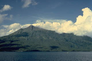 Karangetang volcano, also known as Api Siau, is one of Indonesia's most active volcanoes, with more than 40 eruptions recorded since 1675. Located in the center of the Sangihe island chain north of Sulawesi, Karangetang contains five summit craters oriented along a N-S line. Frequently active in the 20th century, Karangetang has produced explosive eruptions, lava dome growth, and pyroclastic flows.
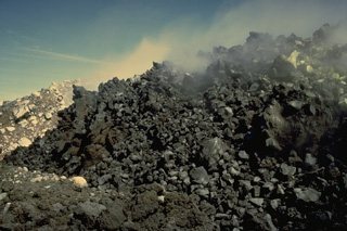 A lava dome, seen here in November 1971, was emplaced in the summit crater at end of an eruption that lasted from November 1970 to March 1971. Emplacement of the dome was accompanied by pyroclastic avalanches down the west flank. The eruption included explosive activity and emission of a lava flow down the east flank.
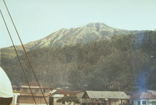 Karangetang volcano, also known as Api Siau, is the northernmost of a chain of volcanoes forming the elongated island of Siau in the Sangihe arc. Seen here from Ulu village on the north, Karangetang is one of Indonesia's most active volcanoes, with more than 40 eruptions recorded since 1675.
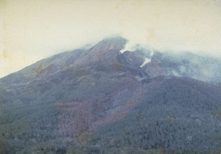 Steam rises from a lava flow descending the north flank in 1976, viewed from Ulu village. A period of almost continuous eruptive activity that began in January 1972 ended in April 1976. Intermittent explosive eruptions were accompanied by lava dome growth and lava flows and lahars.
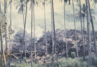 A blocky lava flow descends into a coconut grove during an eruption in 1976. This eruption, which lasted from July 1976 to September 1977, originated from a south-flank vent and produced a lava flow that traveled 7 km to the sea. The lava flow destroyed 24 houses and thousands of coconut and olive trees.
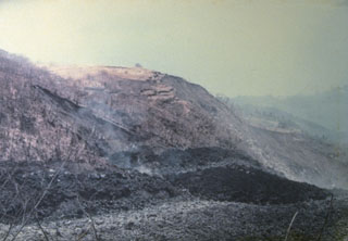 An eruption began on September 15, 1976, from a new vent on the south flank at 1000 m altitude. It produced a lava flow, seen in the foreground of this photo, that traveled 7 km to reach the sea on the SW flank. Pyroclastic flows from collapse of the lava flow's terminous scorched vegetation near the flow, destroyed houses, and caused one fatality. The eruption lasted until September of the following year.
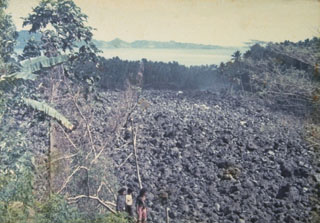 A blocky lava flow, seen here from the NW, descends the southern flank of Karengetang (Api Siau) volcano in 1976. An eruption began on September 15 from a new vent on the south flank at 1000 m altitude. The lava flow traveled 7 km to reach the sea on the SW flank. Pyroclastic flows from collapse of the lava flow's terminous scorched vegetation near the flow, destroyed houses, and caused one fatality. Minor cauliflower-like gas emission accompanied by rumblings continued until the end of the eruption in September of the following year.
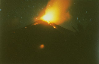 A time exposure captures a nighttime view from the south of explosive eruptions at the summit of Karangetang volcano in February 1985, part of an eruption that began in May 1983 and lasted until the end of 1988. On February 24, 1985, a new vent opened on the south flank, sending a lava flow down the Batuawang River.
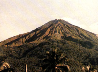 Karangetang (Api Siau) volcano rises above the Pengamatan Maralawa volcano observation post of the Volcanological Survey of Indonesia near the village of Salili on the southern flank. Karangetang is one of Indonesia's most active volcanoes. Twentieth-century eruptions have included frequent explosive activity that is sometimes accompanied by pyroclastic flows and lahars. Lava dome growth has occurred in the summit craters; collapse of lava flow fronts has also produced pyroclastic flows.
 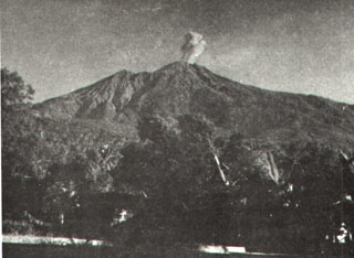 An eruption plume above the summit of Karengetang (Api Siau) volcano is seen from Ulu village on the northern flank sometime during 1961. Explosive eruptions in that year began on February 28 and lasted until April. Incandescent material was ejected to 300 m above the vent and the eruption plume rose 1.5 km above the crater. Explosive activity also occurred in October 1961.
 Karangetang (Api Siau) is one of Indonesia's most active volcanoes. Twentieth-century eruptions have included frequent explosive activity that is sometimes accompanied by pyroclastic flows and lahars. Lava dome growth has occurred in the summit craters; collapse of lava flow fronts has also produced pyroclastic flows.
 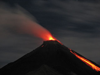 A night time view on August 28, 2007 shows incandescent ejecta from the summit crater and glowing rock avalanches down the flanks. Activity at the frequently active Karangetang volcano had resumed with a small eruption on July 3, 2006 that produced an ash plume. On July 12 lava flows were observed descending to the east, and a pyroclastic flow occurred on July 21. Lava flows were also reported in August, and intermittent explosive activity continued in 2007.
 The maps shown below have been scanned from the GVP map archives and include the volcano on this page. Clicking on the small images will load the full 300 dpi map. Very small-scale maps (such as world maps) are not included. The maps database originated over 30 years ago, but was only recently updated and connected to our main database. We welcome users to tell us if they see incorrect information or other problems with the maps; please use the Contact GVP link at the bottom of the page to send us email.
The following 1 samples associated with this volcano can be found in the Smithsonian's NMNH Department of Mineral Sciences collections, and may be availble for research (contact the Rock and Ore Collections Manager). Catalog number links will open a window with more information.
| Catalog Number | Sample Description | Lava Source | Collection Date |
|---|---|---|---|
| NMNH 116691-23 | Volcanic Rock | -- | 27 Nov 1971 |
| Copernicus Browser | The Copernicus Browser replaced the Sentinel Hub Playground browser in 2023, to provide access to Earth observation archives from the Copernicus Data Space Ecosystem, the main distribution platform for data from the EU Copernicus missions. |
| MIROVA | Middle InfraRed Observation of Volcanic Activity (MIROVA) is a near real time volcanic hot-spot detection system based on the analysis of MODIS (Moderate Resolution Imaging Spectroradiometer) data. In particular, MIROVA uses the Middle InfraRed Radiation (MIR), measured over target volcanoes, in order to detect, locate and measure the heat radiation sourced from volcanic activity. |
| MODVOLC Thermal Alerts | Using infrared satellite Moderate Resolution Imaging Spectroradiometer (MODIS) data, scientists at the Hawai'i Institute of Geophysics and Planetology, University of Hawai'i, developed an automated system called MODVOLC to map thermal hot-spots in near real time. For each MODIS image, the algorithm automatically scans each 1 km pixel within it to check for high-temperature hot-spots. When one is found the date, time, location, and intensity are recorded. MODIS looks at every square km of the Earth every 48 hours, once during the day and once during the night, and the presence of two MODIS sensors in space allows at least four hot-spot observations every two days. Each day updated global maps are compiled to display the locations of all hot spots detected in the previous 24 hours. There is a drop-down list with volcano names which allow users to 'zoom-in' and examine the distribution of hot-spots at a variety of spatial scales. |
|
WOVOdat
Single Volcano View Temporal Evolution of Unrest Side by Side Volcanoes |
WOVOdat is a database of volcanic unrest; instrumentally and visually recorded changes in seismicity, ground deformation, gas emission, and other parameters from their normal baselines. It is sponsored by the World Organization of Volcano Observatories (WOVO) and presently hosted at the Earth Observatory of Singapore.
GVMID Data on Volcano Monitoring Infrastructure The Global Volcano Monitoring Infrastructure Database GVMID, is aimed at documenting and improving capabilities of volcano monitoring from the ground and space. GVMID should provide a snapshot and baseline view of the techniques and instrumentation that are in place at various volcanoes, which can be use by volcano observatories as reference to setup new monitoring system or improving networks at a specific volcano. These data will allow identification of what monitoring gaps exist, which can be then targeted by remote sensing infrastructure and future instrument deployments. |
| Volcanic Hazard Maps | The IAVCEI Commission on Volcanic Hazards and Risk has a Volcanic Hazard Maps database designed to serve as a resource for hazard mappers (or other interested parties) to explore how common issues in hazard map development have been addressed at different volcanoes, in different countries, for different hazards, and for different intended audiences. In addition to the comprehensive, searchable Volcanic Hazard Maps Database, this website contains information about diversity of volcanic hazard maps, illustrated using examples from the database. This site is for educational purposes related to volcanic hazard maps. Hazard maps found on this website should not be used for emergency purposes. For the most recent, official hazard map for a particular volcano, please seek out the proper institutional authorities on the matter. |
| IRIS seismic stations/networks | Incorporated Research Institutions for Seismology (IRIS) Data Services map showing the location of seismic stations from all available networks (permanent or temporary) within a radius of 0.18° (about 20 km at mid-latitudes) from the given location of Karangetang. Users can customize a variety of filters and options in the left panel. Note that if there are no stations are known the map will default to show the entire world with a "No data matched request" error notice. |
| UNAVCO GPS/GNSS stations | Geodetic Data Services map from UNAVCO showing the location of GPS/GNSS stations from all available networks (permanent or temporary) within a radius of 20 km from the given location of Karangetang. Users can customize the data search based on station or network names, location, and time window. Requires Adobe Flash Player. |
| DECADE Data | The DECADE portal, still in the developmental stage, serves as an example of the proposed interoperability between The Smithsonian Institution's Global Volcanism Program, the Mapping Gas Emissions (MaGa) Database, and the EarthChem Geochemical Portal. The Deep Earth Carbon Degassing (DECADE) initiative seeks to use new and established technologies to determine accurate global fluxes of volcanic CO2 to the atmosphere, but installing CO2 monitoring networks on 20 of the world's 150 most actively degassing volcanoes. The group uses related laboratory-based studies (direct gas sampling and analysis, melt inclusions) to provide new data for direct degassing of deep earth carbon to the atmosphere. |
| Large Eruptions of Karangetang | Information about large Quaternary eruptions (VEI >= 4) is cataloged in the Large Magnitude Explosive Volcanic Eruptions (LaMEVE) database of the Volcano Global Risk Identification and Analysis Project (VOGRIPA). |
| EarthChem | EarthChem develops and maintains databases, software, and services that support the preservation, discovery, access and analysis of geochemical data, and facilitate their integration with the broad array of other available earth science parameters. EarthChem is operated by a joint team of disciplinary scientists, data scientists, data managers and information technology developers who are part of the NSF-funded data facility Integrated Earth Data Applications (IEDA). IEDA is a collaborative effort of EarthChem and the Marine Geoscience Data System (MGDS). |

