Phreatic explosion on 16 August
According to a Japan Meteorological Agency (JMA) volcanic advisory issued in the evening of 16 August, a tourist reported a small-scale phreatic explosion at the Karanuma ("Empty Pond") crater near the summit. The explosion occurred at about noon on 16 August. Seismometers at the volcano recorded volcanic tremors during 1053-1204; high numbers of volcanic earthquakes were recorded in the days following the explosion (table 1). JMA estimated that the epicenters were just below the summit.
Table 1. Seismic activity at Akita-Yake-yama during 16-25 August 1997. Reported on the Volcano Research Center's Current Eruptions in Japan website from JMA reports for 22 and 25 August.
| Date | Volcanic earthquakes | Tremors |
| 16 Aug 1997 | 62 | 2 |
| 17 Aug 1997 | 81 | 1 |
| 18 Aug 1997 | 71 | 0 |
| 19 Aug 1997 | 448 | 1 |
| 20 Aug 1997 | 226 | 0 |
| 21 Aug 1997 | 27 | 0 |
| 22 Aug 1997 | 14 | 0 |
| 23 Aug 1997 | 18 | 0 |
| 24 Aug 1997 | 14 | 0 |
| 25 Aug 1997 | 10 | 0 (by 1500) |
A 17 August JMA report detailed the discovery of a new crater 20 m in diameter on the SE rim of Karanuma Crater. Eruptive material including fragments up to 20 cm in diameter were found around the new crater, and volcanic ash "pastes" had been sprayed ~300 m to the S. The report noted that the new crater no longer emitted an eruption cloud on 17 August.
T. Oba and T. Hasenaka, geologists at Tohoku University, conducted a field inspection on 17 August. They reported that the new crater was quiet, and that it had a depth of ~30 m. Fragments up to 30 cm across had been thrown ~25 m away from the crater, but no juvenile materials were included. Ash deposits on the ridge 20-30 m S of the new crater were 4-5 mm thick. The scientists suggested that the 16 August eruption may have created a "new" crater within an old crater formed in 1949, because the volume of recently erupted material was too small to account for the total volume of the crater.
Shintaro Hayashi, a geologist at Akita University, conducted a field inspection on 18 August; he estimated the volume of fallout from the new crater to be ~1,000 m3. He also reported that a mud flow was generated just before the 16 August explosion issued from small depressions just below the new crater (figure 1). The mud was deposited around the depressions, having flowed part of the way down to the crater floor. The total volume of the mud-flow deposit was estimated at ~20,000 m3.
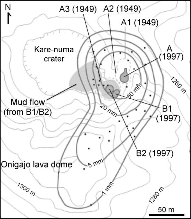 |
Figure 1. Map of Akita-Yake-yama showing recent craters. Craters A1-A3 were formed in 1949; craters A, B1, and B2 were formed in 1997. Heavy lines indicate ash isopachs; dots indicate ash sampling sites. Courtesy of Shintaro Hayashi, Akita University. |
On 20-21 August, new seismometers were installed near the summit and N slope of the volcano; also installed were a microphone on the W foot and cameras (color, high resolution monochromatic, and infrared) on the E foot. Signals are telemetered to Sendai and Akita.
On 22 August, Tatsunori Soya, of the Geological Survey of Japan, drew attention to a document written by the late Prof. H. Tsuya. The document, which appeared in the Tamagawa Hot Spring Study Group's 10th Anniversary Report (1954), describes explosions in 1949, 1950, and 1951 at Akita-Yake-yama; the last two were not officially documented. According to the report, large explosion craters (C1-C4), including the Karanuma crater (C1), existed before the 1949 eruption. Eruptions in 1949 occurred on the E margin of the Karanuma crater, resulting in the formation of craters designated A1, A2, and A3. Although no one in the hot springs area 3 km E of the summit reported hearing an explosion or feeling earthquakes, the eruption products were ~1 m thick along the rim of the A1 crater and contained old lava blocks up to 1 m across. Another explosion occurred at the A1 crater in February 1951; as a result, A1 crater widened to become as much as 50 m across. In terms of volume, the 1951 explosion was smaller than the 1949 eruption. S. Hayashi proposed that the present explosion occurred in A2-A1, and mud spouted out from the A3 crater (figure 1).
Information Contacts: Shintaro Hayashi, Faculty of Education, Akita University, 1-1 Tegata-Gakuen-Cho, Akita 010, Japan; Noritake Nishide, Sendai District Meteorological Observatory, Japan Meteorological Agency, 1-3-5 Gorin, Miyagino-ku, Sendai 983 Japan; Volcano Research Center, University of Tokyo, Yayoi, Bunkyo-ku, Tokyo 113, Japan (URL: http://www.eri.u-tokyo.ac.jp/VRC/index_E.html); Tatsunori Soya, Volcanology Section, Environmental Geology Department, Geological Survey of Japan, 1-1-3, Higashi, Tsukuba, Ibaraki, 305 Japan; Tsukasa Ohba and Toshiaki Hasenaka, Institute of Mineralogy, Petrology, and Economic Geology, Faculty of Science, Tohoku University, Miyagi, Sendai 980-77, Japan.
The Global Volcanism Program has no Weekly Reports available for Akita-Yakeyama.
Reports are organized chronologically and indexed below by Month/Year (Publication Volume:Number), and include a one-line summary. Click on the index link or scroll down to read the reports.
Landslide, explosion, mud- and debris-flows, and tephra
On 11 May, rapid movement of an older landslide was followed by a steam explosion that triggered mud flows and a small tephra emission. The event occurred at Sumikawa-Onsen (a hot spring resort) at the foot of Akita-Yakeyama, ~4 km NE of the summit. The following is based on a report by Shintaro Hayashi.
Although the landslide began moving a few days before 11 May, the sliding accelerated 20 minutes before the explosion. A field party saw the fast-moving landslide and took refuge prior to 0800 on 11 May. The explosion was witnessed at 0800 by a pilot flying over the area; he saw a water-and-steam column rising like a geyser, followed within seconds by black smoke emissions.
The explosion, heard as far as 1.4 km away, triggered a mudflow along the Akagawa River and eventually developed into a debris flow downstream. The field party noticed a thin coat of ash covering the mudflow deposits; they concluded that the tephra had issued from the explosion site.
Hayashi suggested that the explosion was triggered by sudden depressurization of a hot water reservoir under the hot spring due to removal of the overlying debris. The depressurization led to sudden boiling, generating sufficient steam pressure to explode. The volume of erupted material was estimated to be between 1,000 and 10,000 m3.
According to Hiroyuri Hamaguchi the precursory vibration and tremor were recorded by a short-period seismometer 1 km NNE of the hot spring. The landslide was as large as 500 m wide, 150 m long, and 500 m deep. After 2000 on 10 May, tremors of increasing amplitude built up. They declined by midnight and then returned at 0400 on 11 May. A maximum amplitude was reached at 0732, followed by a hiatus during 0753-0757. Short- and long-period events took place at 0757 and 0758, respectively.
Hayakawa reported that two hotels at the foot of Akita Yakeyama were completely destroyed by the landslide and lahar; however, there were no casualties because the staff and guests had evacuated. Air photos taken on 12 May by Asia Air Survey Co. can be seen on the internet.
Information Contacts: Shintaro Hayashi, Faculty of Education, Akita University, 1-1 Tegata-Gakuen-Cho, Akita 010, Japan; Hiroyuki Hamaguchi, Faculty of Science, Tohoku University, Sendai 980-77, Japan; Yukio Hayakawa, Faculty of Education, Gunma University, 4-2 Aramaki-machi, Mae-bashi-chi, Gunma 371, Japan (URL: http://www.hayakawayukio.jp/); Tatsuro Chiba, Dept of Disaster Prevention, Asia Air Survey Co., 4-2-18 Shinjuku, Shinjuku-ku, Tokyo 160, Japan (URL: http://www.ajiko.co.jp/en/).
Phreatic explosion on 16 August
According to a Japan Meteorological Agency (JMA) volcanic advisory issued in the evening of 16 August, a tourist reported a small-scale phreatic explosion at the Karanuma ("Empty Pond") crater near the summit. The explosion occurred at about noon on 16 August. Seismometers at the volcano recorded volcanic tremors during 1053-1204; high numbers of volcanic earthquakes were recorded in the days following the explosion (table 1). JMA estimated that the epicenters were just below the summit.
Table 1. Seismic activity at Akita-Yake-yama during 16-25 August 1997. Reported on the Volcano Research Center's Current Eruptions in Japan website from JMA reports for 22 and 25 August.
| Date | Volcanic earthquakes | Tremors |
| 16 Aug 1997 | 62 | 2 |
| 17 Aug 1997 | 81 | 1 |
| 18 Aug 1997 | 71 | 0 |
| 19 Aug 1997 | 448 | 1 |
| 20 Aug 1997 | 226 | 0 |
| 21 Aug 1997 | 27 | 0 |
| 22 Aug 1997 | 14 | 0 |
| 23 Aug 1997 | 18 | 0 |
| 24 Aug 1997 | 14 | 0 |
| 25 Aug 1997 | 10 | 0 (by 1500) |
A 17 August JMA report detailed the discovery of a new crater 20 m in diameter on the SE rim of Karanuma Crater. Eruptive material including fragments up to 20 cm in diameter were found around the new crater, and volcanic ash "pastes" had been sprayed ~300 m to the S. The report noted that the new crater no longer emitted an eruption cloud on 17 August.
T. Oba and T. Hasenaka, geologists at Tohoku University, conducted a field inspection on 17 August. They reported that the new crater was quiet, and that it had a depth of ~30 m. Fragments up to 30 cm across had been thrown ~25 m away from the crater, but no juvenile materials were included. Ash deposits on the ridge 20-30 m S of the new crater were 4-5 mm thick. The scientists suggested that the 16 August eruption may have created a "new" crater within an old crater formed in 1949, because the volume of recently erupted material was too small to account for the total volume of the crater.
Shintaro Hayashi, a geologist at Akita University, conducted a field inspection on 18 August; he estimated the volume of fallout from the new crater to be ~1,000 m3. He also reported that a mud flow was generated just before the 16 August explosion issued from small depressions just below the new crater (figure 1). The mud was deposited around the depressions, having flowed part of the way down to the crater floor. The total volume of the mud-flow deposit was estimated at ~20,000 m3.
|
Figure 1. Map of Akita-Yake-yama showing recent craters. Craters A1-A3 were formed in 1949; craters A, B1, and B2 were formed in 1997. Heavy lines indicate ash isopachs; dots indicate ash sampling sites. Courtesy of Shintaro Hayashi, Akita University. |
On 20-21 August, new seismometers were installed near the summit and N slope of the volcano; also installed were a microphone on the W foot and cameras (color, high resolution monochromatic, and infrared) on the E foot. Signals are telemetered to Sendai and Akita.
On 22 August, Tatsunori Soya, of the Geological Survey of Japan, drew attention to a document written by the late Prof. H. Tsuya. The document, which appeared in the Tamagawa Hot Spring Study Group's 10th Anniversary Report (1954), describes explosions in 1949, 1950, and 1951 at Akita-Yake-yama; the last two were not officially documented. According to the report, large explosion craters (C1-C4), including the Karanuma crater (C1), existed before the 1949 eruption. Eruptions in 1949 occurred on the E margin of the Karanuma crater, resulting in the formation of craters designated A1, A2, and A3. Although no one in the hot springs area 3 km E of the summit reported hearing an explosion or feeling earthquakes, the eruption products were ~1 m thick along the rim of the A1 crater and contained old lava blocks up to 1 m across. Another explosion occurred at the A1 crater in February 1951; as a result, A1 crater widened to become as much as 50 m across. In terms of volume, the 1951 explosion was smaller than the 1949 eruption. S. Hayashi proposed that the present explosion occurred in A2-A1, and mud spouted out from the A3 crater (figure 1).
Information Contacts: Shintaro Hayashi, Faculty of Education, Akita University, 1-1 Tegata-Gakuen-Cho, Akita 010, Japan; Noritake Nishide, Sendai District Meteorological Observatory, Japan Meteorological Agency, 1-3-5 Gorin, Miyagino-ku, Sendai 983 Japan; Volcano Research Center, University of Tokyo, Yayoi, Bunkyo-ku, Tokyo 113, Japan (URL: http://www.eri.u-tokyo.ac.jp/VRC/index_E.html); Tatsunori Soya, Volcanology Section, Environmental Geology Department, Geological Survey of Japan, 1-1-3, Higashi, Tsukuba, Ibaraki, 305 Japan; Tsukasa Ohba and Toshiaki Hasenaka, Institute of Mineralogy, Petrology, and Economic Geology, Faculty of Science, Tohoku University, Miyagi, Sendai 980-77, Japan.
This compilation of synonyms and subsidiary features may not be comprehensive. Features are organized into four major categories: Cones, Craters, Domes, and Thermal Features. Synonyms of features appear indented below the primary name. In some cases additional feature type, elevation, or location details are provided.
Synonyms |
||||
| Yake-yama | Akita-Yake-yama | ||||
Cones |
||||
| Feature Name | Feature Type | Elevation | Latitude | Longitude |
|
Tsugamori
Tugamori |
Stratovolcano | 1350 m | ||
Craters |
||||
| Feature Name | Feature Type | Elevation | Latitude | Longitude |
| Kani-numa | Crater | |||
| Kare-numa | Crater | |||
Domes |
||||
| Feature Name | Feature Type | Elevation | Latitude | Longitude |
| Kuroishimori | Dome | 1231 m | ||
|
Onigajo
Onigazyo |
Dome | |||
Thermal |
||||
| Feature Name | Feature Type | Elevation | Latitude | Longitude |
|
Goshogake
Gosyogake |
Thermal | |||
| Tamagawa Spa | Thermal | |||
|
|
||||||||||||||||||||||||||
There is data available for 16 confirmed Holocene eruptive periods.
1997 Aug 16 - 1997 Aug 16 Confirmed Eruption Max VEI: 1
| Episode 1 | Eruption Episode | Kare-numa | ||||||||||||||||||||||||||||||||||||||||||||
|---|---|---|---|---|---|---|---|---|---|---|---|---|---|---|---|---|---|---|---|---|---|---|---|---|---|---|---|---|---|---|---|---|---|---|---|---|---|---|---|---|---|---|---|---|---|
| 1997 Aug 16 - 1997 Aug 16 | Evidence from Observations: Reported | ||||||||||||||||||||||||||||||||||||||||||||
|
List of 7 Events for Episode 1 at Kare-numa
| |||||||||||||||||||||||||||||||||||||||||||||
1997 May 11 - 1997 May 11 Confirmed Eruption Max VEI: 1
| Episode 1 | Eruption Episode | NE flank (Sumikawa-Onsen) | |||||||||||||||||||||||||||||||||||||||||||||||||||||||||||
|---|---|---|---|---|---|---|---|---|---|---|---|---|---|---|---|---|---|---|---|---|---|---|---|---|---|---|---|---|---|---|---|---|---|---|---|---|---|---|---|---|---|---|---|---|---|---|---|---|---|---|---|---|---|---|---|---|---|---|---|---|
| 1997 May 11 - 1997 May 11 | Evidence from Observations: Reported | |||||||||||||||||||||||||||||||||||||||||||||||||||||||||||
|
List of 10 Events for Episode 1 at NE flank (Sumikawa-Onsen)
| ||||||||||||||||||||||||||||||||||||||||||||||||||||||||||||
1957 Jul 2 ± 182 days Confirmed Eruption Max VEI: 1
| Episode 1 | Eruption Episode | |||||||||||||||||||||||||
|---|---|---|---|---|---|---|---|---|---|---|---|---|---|---|---|---|---|---|---|---|---|---|---|---|---|
| 1957 Jul 2 ± 182 days - Unknown | Evidence from Observations: Reported | ||||||||||||||||||||||||
|
List of 3 Events for Episode 1
| |||||||||||||||||||||||||
1951 Feb 16 ± 15 days Confirmed Eruption Max VEI: 1
| Episode 1 | Eruption Episode | Kare-numa | |||||||||||||||||||
|---|---|---|---|---|---|---|---|---|---|---|---|---|---|---|---|---|---|---|---|---|
| 1951 Feb 16 ± 15 days - Unknown | Evidence from Observations: Reported | |||||||||||||||||||
|
List of 2 Events for Episode 1 at Kare-numa
| ||||||||||||||||||||
1950 Jul 2 ± 182 days Confirmed Eruption Max VEI: 1
| Episode 1 | Eruption Episode | Kare-numa | |||||||||||||||||||
|---|---|---|---|---|---|---|---|---|---|---|---|---|---|---|---|---|---|---|---|---|
| 1950 Jul 2 ± 182 days - Unknown | Evidence from Observations: Reported | |||||||||||||||||||
|
List of 2 Events for Episode 1 at Kare-numa
| ||||||||||||||||||||
1949 Aug 30 - 1949 Sep 1 Confirmed Eruption Max VEI: 1
| Episode 1 | Eruption Episode | Kare-numa | ||||||||||||||||||||||||||||||||||
|---|---|---|---|---|---|---|---|---|---|---|---|---|---|---|---|---|---|---|---|---|---|---|---|---|---|---|---|---|---|---|---|---|---|---|---|
| 1949 Aug 30 - 1949 Sep 1 | Evidence from Observations: Reported | ||||||||||||||||||||||||||||||||||
|
List of 5 Events for Episode 1 at Kare-numa
| |||||||||||||||||||||||||||||||||||
1948 Confirmed Eruption Max VEI: 1 (?)
| Episode 1 | Eruption Episode | Kare-numa | |||||||||||||||||||
|---|---|---|---|---|---|---|---|---|---|---|---|---|---|---|---|---|---|---|---|---|
| 1948 - Unknown | Evidence from Observations: Reported | |||||||||||||||||||
|
List of 2 Events for Episode 1 at Kare-numa
| ||||||||||||||||||||
1929 Sep Confirmed Eruption Max VEI: 2
| Episode 1 | Eruption Episode | |||||||||||||||||||||||||
|---|---|---|---|---|---|---|---|---|---|---|---|---|---|---|---|---|---|---|---|---|---|---|---|---|---|
| 1929 Sep - Unknown | Evidence from Observations: Reported | ||||||||||||||||||||||||
|
List of 3 Events for Episode 1
| |||||||||||||||||||||||||
1890 Sep 23 Confirmed Eruption Max VEI: 2
| Episode 1 | Eruption Episode | |||||||||||||||||||||||||
|---|---|---|---|---|---|---|---|---|---|---|---|---|---|---|---|---|---|---|---|---|---|---|---|---|---|
| 1890 Sep 23 - Unknown | Evidence from Observations: Reported | ||||||||||||||||||||||||
|
List of 3 Events for Episode 1
| |||||||||||||||||||||||||
1887 Confirmed Eruption Max VEI: 2
| Episode 1 | Eruption Episode | Karenuma | |||||||||||||||||||
|---|---|---|---|---|---|---|---|---|---|---|---|---|---|---|---|---|---|---|---|---|
| 1887 - Unknown | Evidence from Observations: Reported | |||||||||||||||||||
|
List of 2 Events for Episode 1 at Karenuma
| ||||||||||||||||||||
1867 Confirmed Eruption
| Episode 1 | Eruption Episode | |||||||||||||||
|---|---|---|---|---|---|---|---|---|---|---|---|---|---|---|---|
| 1867 - Unknown | Evidence from Observations: Reported | ||||||||||||||
|
List of 1 Events for Episode 1
| |||||||||||||||
1678 Feb 22 (?) Confirmed Eruption Max VEI: 2
| Episode 1 | Eruption Episode | Karenuma | ||||||||||||||||||||||||||||||||||
|---|---|---|---|---|---|---|---|---|---|---|---|---|---|---|---|---|---|---|---|---|---|---|---|---|---|---|---|---|---|---|---|---|---|---|---|
| 1678 Feb 22 (?) - Unknown | Evidence from Observations: Reported | ||||||||||||||||||||||||||||||||||
|
List of 5 Events for Episode 1 at Karenuma
| |||||||||||||||||||||||||||||||||||
1390 ± 75 years Confirmed Eruption
| Episode 1 | Eruption Episode | |||||||||||||||
|---|---|---|---|---|---|---|---|---|---|---|---|---|---|---|---|
| 1390 ± 75 years - Unknown | Evidence from Isotopic: 14C (calibrated) | ||||||||||||||
|
List of 1 Events for Episode 1
| |||||||||||||||
[ 0807 Nov 1 ] Uncertain Eruption
| Episode 1 | Eruption Episode | ||||||||||||||||||||
|---|---|---|---|---|---|---|---|---|---|---|---|---|---|---|---|---|---|---|---|---|
| 0807 Nov 1 - Unknown | Evidence from Unknown | |||||||||||||||||||
|
List of 2 Events for Episode 1
| ||||||||||||||||||||
0570 (?) Confirmed Eruption
| Episode 1 | Eruption Episode | Ay-2 tephra | ||||||||||||||||||||||||
|---|---|---|---|---|---|---|---|---|---|---|---|---|---|---|---|---|---|---|---|---|---|---|---|---|---|
| 0570 (?) - Unknown | Evidence from Correlation: Tephrochronology | ||||||||||||||||||||||||
|
List of 3 Events for Episode 1 at Ay-2 tephra
| |||||||||||||||||||||||||
1250 BCE ± 200 years Confirmed Eruption
| Episode 1 | Eruption Episode | ||||||||||||||||||||
|---|---|---|---|---|---|---|---|---|---|---|---|---|---|---|---|---|---|---|---|---|
| 1250 BCE ± 200 years - Unknown | Evidence from Isotopic: 14C (calibrated) | |||||||||||||||||||
|
List of 2 Events for Episode 1
| ||||||||||||||||||||
3050 BCE (?) Confirmed Eruption
| Episode 1 | Eruption Episode | Onigajo lava dome | ||||||||||||||
|---|---|---|---|---|---|---|---|---|---|---|---|---|---|---|---|
| 3050 BCE (?) - Unknown | Evidence from Radiogenic: Thermoluminescence | ||||||||||||||
|
List of 1 Events for Episode 1 at Onigajo lava dome
| |||||||||||||||
There is no Deformation History data available for Akita-Yakeyama.
There is no Emissions History data available for Akita-Yakeyama.
The maps shown below have been scanned from the GVP map archives and include the volcano on this page. Clicking on the small images will load the full 300 dpi map. Very small-scale maps (such as world maps) are not included. The maps database originated over 30 years ago, but was only recently updated and connected to our main database. We welcome users to tell us if they see incorrect information or other problems with the maps; please use the Contact GVP link at the bottom of the page to send us email.
There are no samples for Akita-Yakeyama in the Smithsonian's NMNH Department of Mineral Sciences Rock and Ore collection.
| Copernicus Browser | The Copernicus Browser replaced the Sentinel Hub Playground browser in 2023, to provide access to Earth observation archives from the Copernicus Data Space Ecosystem, the main distribution platform for data from the EU Copernicus missions. |
| MIROVA | Middle InfraRed Observation of Volcanic Activity (MIROVA) is a near real time volcanic hot-spot detection system based on the analysis of MODIS (Moderate Resolution Imaging Spectroradiometer) data. In particular, MIROVA uses the Middle InfraRed Radiation (MIR), measured over target volcanoes, in order to detect, locate and measure the heat radiation sourced from volcanic activity. |
| MODVOLC Thermal Alerts | Using infrared satellite Moderate Resolution Imaging Spectroradiometer (MODIS) data, scientists at the Hawai'i Institute of Geophysics and Planetology, University of Hawai'i, developed an automated system called MODVOLC to map thermal hot-spots in near real time. For each MODIS image, the algorithm automatically scans each 1 km pixel within it to check for high-temperature hot-spots. When one is found the date, time, location, and intensity are recorded. MODIS looks at every square km of the Earth every 48 hours, once during the day and once during the night, and the presence of two MODIS sensors in space allows at least four hot-spot observations every two days. Each day updated global maps are compiled to display the locations of all hot spots detected in the previous 24 hours. There is a drop-down list with volcano names which allow users to 'zoom-in' and examine the distribution of hot-spots at a variety of spatial scales. |
|
WOVOdat
Single Volcano View Temporal Evolution of Unrest Side by Side Volcanoes |
WOVOdat is a database of volcanic unrest; instrumentally and visually recorded changes in seismicity, ground deformation, gas emission, and other parameters from their normal baselines. It is sponsored by the World Organization of Volcano Observatories (WOVO) and presently hosted at the Earth Observatory of Singapore.
GVMID Data on Volcano Monitoring Infrastructure The Global Volcano Monitoring Infrastructure Database GVMID, is aimed at documenting and improving capabilities of volcano monitoring from the ground and space. GVMID should provide a snapshot and baseline view of the techniques and instrumentation that are in place at various volcanoes, which can be use by volcano observatories as reference to setup new monitoring system or improving networks at a specific volcano. These data will allow identification of what monitoring gaps exist, which can be then targeted by remote sensing infrastructure and future instrument deployments. |
| Volcanic Hazard Maps | The IAVCEI Commission on Volcanic Hazards and Risk has a Volcanic Hazard Maps database designed to serve as a resource for hazard mappers (or other interested parties) to explore how common issues in hazard map development have been addressed at different volcanoes, in different countries, for different hazards, and for different intended audiences. In addition to the comprehensive, searchable Volcanic Hazard Maps Database, this website contains information about diversity of volcanic hazard maps, illustrated using examples from the database. This site is for educational purposes related to volcanic hazard maps. Hazard maps found on this website should not be used for emergency purposes. For the most recent, official hazard map for a particular volcano, please seek out the proper institutional authorities on the matter. |
| IRIS seismic stations/networks | Incorporated Research Institutions for Seismology (IRIS) Data Services map showing the location of seismic stations from all available networks (permanent or temporary) within a radius of 0.18° (about 20 km at mid-latitudes) from the given location of Akita-Yakeyama. Users can customize a variety of filters and options in the left panel. Note that if there are no stations are known the map will default to show the entire world with a "No data matched request" error notice. |
| UNAVCO GPS/GNSS stations | Geodetic Data Services map from UNAVCO showing the location of GPS/GNSS stations from all available networks (permanent or temporary) within a radius of 20 km from the given location of Akita-Yakeyama. Users can customize the data search based on station or network names, location, and time window. Requires Adobe Flash Player. |
| DECADE Data | The DECADE portal, still in the developmental stage, serves as an example of the proposed interoperability between The Smithsonian Institution's Global Volcanism Program, the Mapping Gas Emissions (MaGa) Database, and the EarthChem Geochemical Portal. The Deep Earth Carbon Degassing (DECADE) initiative seeks to use new and established technologies to determine accurate global fluxes of volcanic CO2 to the atmosphere, but installing CO2 monitoring networks on 20 of the world's 150 most actively degassing volcanoes. The group uses related laboratory-based studies (direct gas sampling and analysis, melt inclusions) to provide new data for direct degassing of deep earth carbon to the atmosphere. |
| Large Eruptions of Akita-Yakeyama | Information about large Quaternary eruptions (VEI >= 4) is cataloged in the Large Magnitude Explosive Volcanic Eruptions (LaMEVE) database of the Volcano Global Risk Identification and Analysis Project (VOGRIPA). |
| EarthChem | EarthChem develops and maintains databases, software, and services that support the preservation, discovery, access and analysis of geochemical data, and facilitate their integration with the broad array of other available earth science parameters. EarthChem is operated by a joint team of disciplinary scientists, data scientists, data managers and information technology developers who are part of the NSF-funded data facility Integrated Earth Data Applications (IEDA). IEDA is a collaborative effort of EarthChem and the Marine Geoscience Data System (MGDS). |


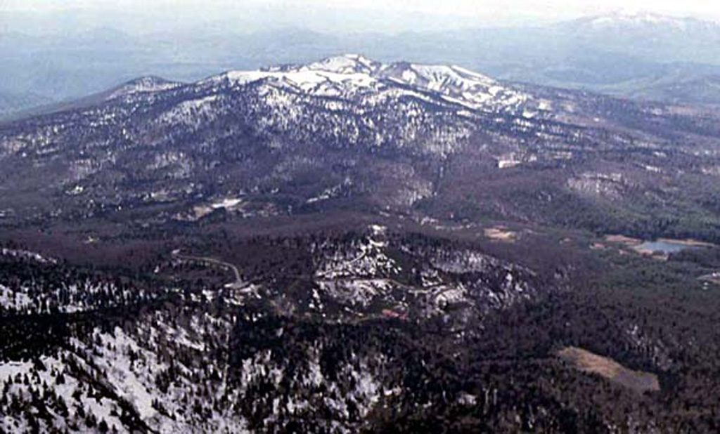
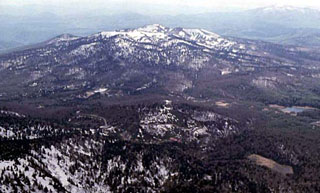 Akita-Yakeyama, seen here from the E, is one of several Japanese volcanoes named Yakeyama ("Burning Mountain"). Yakeyama contains a lava dome in its 600-m-wide summit crater and the flat-topped Kuroshimori lava dome is visible to the left. Several thermal areas are located on the lower western flank.