2007 M~3.3 earthquake followed by clouds of equivocal origin
Our last report on Agrigan volcano covered a May 1992 field visit (BGVN 17:06) by a six-member team of USGS volcanologists that visited the Commonwealth of the Northern Mariana Islands (CNMI) at the request of the CNMI Office of Civil Defense. The team detected thermal activity, but no seismicity, deformation or other signs of an eruption.
The following came from a report by both the USGS and CNMI issued mid-July 2007and labeled Current Update. "An earthquake was reported felt on Agrigan island at 3:49 pm July 16 local time. About 3 seconds of shaking was reported by a local resident. Seismometers on Sarigan and Anatahan recorded the earthquake and allowed estimation the magnitude at approximately 3.3. No sulfur smell or any other signs of volcanic activity were reported on July 16 or in a follow up call on July 17."
Some 2012 and 2013 observations were equivocal. On 29 February 2012, NOAA's Washington Volcanic Ash Advisory Center (VAAC) inferred ash and gas emissions here for the first time on record, but this was later discounted due to lack of forthcoming evidence. The inferred plume was seen in satellite infrared imagery. It extended 74 km NW from the summit.
A possible volcanic plume from Agrigan was spotted again by the VAAC in a satellite image from 22 January 2013.
In a 25 January 2013 USGS update, it was noted that neither the USGS nor NOAA received confirmation of a volcanic source for the satellite anomalies. The authors of the 2013 update interpreted the cloud as weather-related and not volcanic in origin.
Figure 2 shows a photo of Agrigan taken in June 2013. No hotspots were detected during mid-2012 to mid-2013 by the MODVOLC Thermal Alerts System.
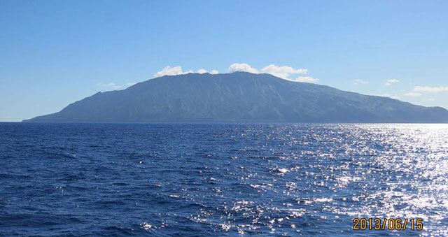 |
Figure 2. Agrigan as seen on 15 June 2013. Photo credit to Yoshi Tamura; featured here thanks to cooperation of Robert Stern. |
Agrigan, the highest-standing stratovolcano and largest (by subaerial volume) in the Northern Mariana Islands, stands 882 m a.s.l (figure 3). The island is ~10 by 6.5 km (N-S by E-W) in size, with a surface area of 52.7 km2. The volcano's subaerial volume is ~15.9 km3. The summit contains a large depression, roughly 1.5 by 1.2 km in diameter, and 380 m deep. A spatter cone and flows from the 1917 eruption cover ~50 percent of the crater floor. This large crater implies a local edifice with shallow magma storage within the volcano. The flanks of the volcano are steep (>30 degrees), with deep furrows extending radially away from the crater. To the north is a large canyon into which a recent, large 'a'ā flow advanced to form a delta on the coast. Pyroclastic flow deposits mantle most of the interior of the island. Rocks erupted on the island range from basalt to andesite. The southwest coast has several beaches composed of mineral sands; otherwise, the coast is rocky. (Trusdell, F.A. and others, 2009).
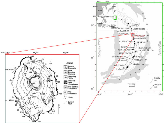 |
Figure 3. Geologic map of Agrigan with 200 m contour intervals (after Stern, 1978) and location map (after Trusdell and others, 2006). |
References. Sako, M. K.; Trusdell, F. A.; Koyanagi, R. Y.; Kojima, George; Moore, R. B., 1995, Volcanic investigations in the Commonwealth of the Northern Mariana Islands, April to May 1994, USGS Open-File Report 94-705.
Stern, R.J., 1978, Agrigan: an introduction to the geology of an active volcano in the Northern Mariana Arc: Bulletin of Volcanology, v. 41, p. 43-55.
Trusdell, F.A., Moore, R.B., and Sako, M.K., 2006. Preliminary Geologic Map of Mount Pagan Volcano, Pagan Island, Commonwealth of the Northern Mariana Islands, USGS Open-File Report 2006-1386 (URL: http://pubs.usgs.gov/of/2006/1386/).
Trusdell, F.A. 2009, Geology of the Mariana Islands, in Gillespie, R.G., and Clague, D.A., eds., Encyclopedia of Islands: Enclyclopedias of the Natural World, 2, University of California Press, Chap. 18. P. 598-603.
Information Contacts: Emergency Management Office of the Commonwealth of the Northern Mariana Islands (EMO-CNMI) and USGS Volcano Hazards Program, PO Box 100007, Saipan, MP 96950, USA (URL: http://www.cnmihsem.gov.mp/ and http://volcanoes.usgs.gov/nmi/activity/); Washington Volcanic Ash Advisory Center (VAAC), Satellite Analysis Branch (SAB), NOAA/NESDIS E/SP23, NOAA Science Center Room 401, 5200 Auth Rd, Camp Springs, MD 20746, USA (URL: http://www.ospo.noaa.gov/Products/atmosphere/vaac/); Hawai'i Institute of Geophysics and Planetology (HIGP), MODVOLC Thermal Alerts System, School of Ocean and Earth Science and Technology (SOEST), Univ. of Hawai'i, 2525 Correa Road, Honolulu, HI 96822, USA (URL://httphotspot.higp); Robert J. Stern, University of Texas at Dallas, 800 W Campbell Rd Richardson, TX 75080; and Yoshi Tamura, Institute for Research on Earth Evolution (IFREE), Japan Agency for Marine-Earth Science and Technology (JAMSTEC), Yokosuka 237-0061, Japan.
The Global Volcanism Program has no Weekly Reports available for Agrigan.
Reports are organized chronologically and indexed below by Month/Year (Publication Volume:Number), and include a one-line summary. Click on the index link or scroll down to read the reports.
Increased fumarolic activity; nine evacuated
An overflight on 1 August revealed increased fumarolic activity at the volcano [(figure 1)]. Nine residents were evacuated from the island. No felt earthquakes were reported.
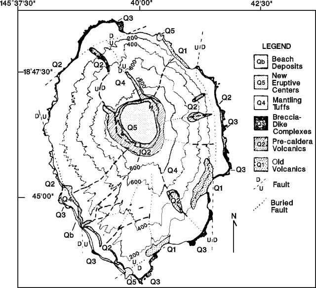 |
Figure 1. Geologic map of Agrigan after Stern (1978). Contour interval is 200 m. |
Reference. Stern, R.J., 1978, Agrigan: an introduction to the geology of an active volcano in the Northern Mariana Arc: BV, v. 41, p. 43-55.
Information Contacts: R. Koyanagi, HVO; F. Sasamoto, Office of Civil Defense, Saipan.
Weak fumaroles; no sign of recent increase in activity
Fieldwork was conducted . . . 28 September-3 October, following reports of increased activity 1 August and the subsequent evacuation of the island's residents. Visits to the summit revealed weak fumarolic activity with sulfur deposition and boiling hot springs. A preliminary seismic study indicated very low levels of local activity, with no sign of a recent increase. A regional network of single vertical-component, short-period seismometers was installed, with instruments located on the islands of Pagan, Alamagan, and Anatahan, and a receiving station on Saipan. The residents evacuated in August had not returned to their homes as of early October.
Information Contacts: R. Koyanagi, HVO.
Strong thermal activity but no unusual seismicity
A seven-member team of USGS volcanologists visited the CNMI 24 September-6 October at the request of the Office of Civil Defense. The following is from a report by Richard Moore.
"On Agrigan, the team established a new EDM network within the summit caldera, and hope to remeasure it in 1991. At that time, geologic investigations terminated by tropical storm Hattie on 2 October 1990 would be continued.
"A revolving drum seismograph operated continuously 28 September-1 October at a village near the coast, and a portable seismograph operated intermittently 28-29 September at several sites on the caldera floor, recorded no sustained microearthquake activity or volcanic tremor on Agrigan.
"The team discovered a boiling hot spring, associated terrace deposits, and solfataras at the 1917 eruption vent (Agrigan's most recent) on the floor of the 1.5-km-diameter caldera. Steam was being emitted from several areas at the base of the caldera wall. Temperatures of the boiling hot spring and 25 solfataras measured by thermocouple were all 98°C. Water from the hot spring had a pH of 2.0. Chemical analysis of the water is in progress. Several measurements (using Kitagawa and Draeger tubes) of the abundances of various gases emitted by the solfataras are summarized in table 1.
Table 1. Range in compositions of gas samples collected at Agrigan, September-October 1990. Courtesy of Richard Moore.
| Gas | Abundance |
| HCl | 200 - 320 ppm |
| CO | 0 - 3 ppm |
| CO2 | >3% |
| H2S | 1900 - >2000 ppm |
| SO2 | >400 ppm |
"The team found no evidence of new fuming on Agrigan (suggested by reports in August and cause of the island's evacuation; 15:7). Hot spring terraces composed of siliceous sinter covered an area of ~20 x 7 m2 below the boiling hot spring. The terraces are now mostly dry, with current deposition of silica limited to a few square meters adjacent to the hot spring, suggesting that activity was more vigorous sometime in the past. However, fluctuations in the volume of flow from the spring may occur as a result of seasonal variations in rainfall."
Information Contacts: R. Moore, USGS; R. Koyanagi and M. Sako, HVO.
Thermal activity but no seismicity or deformation
A six-member team of USGS volcanologists visited the Commonwealth of the Northern Mariana Islands 11-27 May 1992 at the request of the CNMI Office of Civil Defense. The team observed all of the islands in the chain N of Saipan, installed a new seismic station at the base of frequently active Pagan, remeasured existing EDM networks, mapped the geology of Alamagan, sampled fumaroles and hot springs, and collected rocks and charcoal for radiocarbon dating. No volcanoes in the chain erupted during the observation period.
Remeasurement of five EDM lines on 15-16 May yielded no significant changes (>1 cm) since the network was established in September 1990. Two seismometers temporarily operated on the caldera floor recorded no local shallow seismicity. The temperature of the boiling spring in the caldera was 98°C, the same as in 1990. The volume of water issuing from the hot spring was less than in 1990, maybe because of seasonal rainfall variations. The highest measured fumarole temperature was 102°C, 4° higher than in 1990, perhaps related to a drop in the water table.
Information Contacts: R. Moore, USGS; R. Koyanagi, M. Sako, and F. Trusdell, HVO.
2007 M~3.3 earthquake followed by clouds of equivocal origin
Our last report on Agrigan volcano covered a May 1992 field visit (BGVN 17:06) by a six-member team of USGS volcanologists that visited the Commonwealth of the Northern Mariana Islands (CNMI) at the request of the CNMI Office of Civil Defense. The team detected thermal activity, but no seismicity, deformation or other signs of an eruption.
The following came from a report by both the USGS and CNMI issued mid-July 2007and labeled Current Update. "An earthquake was reported felt on Agrigan island at 3:49 pm July 16 local time. About 3 seconds of shaking was reported by a local resident. Seismometers on Sarigan and Anatahan recorded the earthquake and allowed estimation the magnitude at approximately 3.3. No sulfur smell or any other signs of volcanic activity were reported on July 16 or in a follow up call on July 17."
Some 2012 and 2013 observations were equivocal. On 29 February 2012, NOAA's Washington Volcanic Ash Advisory Center (VAAC) inferred ash and gas emissions here for the first time on record, but this was later discounted due to lack of forthcoming evidence. The inferred plume was seen in satellite infrared imagery. It extended 74 km NW from the summit.
A possible volcanic plume from Agrigan was spotted again by the VAAC in a satellite image from 22 January 2013.
In a 25 January 2013 USGS update, it was noted that neither the USGS nor NOAA received confirmation of a volcanic source for the satellite anomalies. The authors of the 2013 update interpreted the cloud as weather-related and not volcanic in origin.
Figure 2 shows a photo of Agrigan taken in June 2013. No hotspots were detected during mid-2012 to mid-2013 by the MODVOLC Thermal Alerts System.
|
Figure 2. Agrigan as seen on 15 June 2013. Photo credit to Yoshi Tamura; featured here thanks to cooperation of Robert Stern. |
Agrigan, the highest-standing stratovolcano and largest (by subaerial volume) in the Northern Mariana Islands, stands 882 m a.s.l (figure 3). The island is ~10 by 6.5 km (N-S by E-W) in size, with a surface area of 52.7 km2. The volcano's subaerial volume is ~15.9 km3. The summit contains a large depression, roughly 1.5 by 1.2 km in diameter, and 380 m deep. A spatter cone and flows from the 1917 eruption cover ~50 percent of the crater floor. This large crater implies a local edifice with shallow magma storage within the volcano. The flanks of the volcano are steep (>30 degrees), with deep furrows extending radially away from the crater. To the north is a large canyon into which a recent, large 'a'ā flow advanced to form a delta on the coast. Pyroclastic flow deposits mantle most of the interior of the island. Rocks erupted on the island range from basalt to andesite. The southwest coast has several beaches composed of mineral sands; otherwise, the coast is rocky. (Trusdell, F.A. and others, 2009).
|
Figure 3. Geologic map of Agrigan with 200 m contour intervals (after Stern, 1978) and location map (after Trusdell and others, 2006). |
References. Sako, M. K.; Trusdell, F. A.; Koyanagi, R. Y.; Kojima, George; Moore, R. B., 1995, Volcanic investigations in the Commonwealth of the Northern Mariana Islands, April to May 1994, USGS Open-File Report 94-705.
Stern, R.J., 1978, Agrigan: an introduction to the geology of an active volcano in the Northern Mariana Arc: Bulletin of Volcanology, v. 41, p. 43-55.
Trusdell, F.A., Moore, R.B., and Sako, M.K., 2006. Preliminary Geologic Map of Mount Pagan Volcano, Pagan Island, Commonwealth of the Northern Mariana Islands, USGS Open-File Report 2006-1386 (URL: http://pubs.usgs.gov/of/2006/1386/).
Trusdell, F.A. 2009, Geology of the Mariana Islands, in Gillespie, R.G., and Clague, D.A., eds., Encyclopedia of Islands: Enclyclopedias of the Natural World, 2, University of California Press, Chap. 18. P. 598-603.
Information Contacts: Emergency Management Office of the Commonwealth of the Northern Mariana Islands (EMO-CNMI) and USGS Volcano Hazards Program, PO Box 100007, Saipan, MP 96950, USA (URL: http://www.cnmihsem.gov.mp/ and http://volcanoes.usgs.gov/nmi/activity/); Washington Volcanic Ash Advisory Center (VAAC), Satellite Analysis Branch (SAB), NOAA/NESDIS E/SP23, NOAA Science Center Room 401, 5200 Auth Rd, Camp Springs, MD 20746, USA (URL: http://www.ospo.noaa.gov/Products/atmosphere/vaac/); Hawai'i Institute of Geophysics and Planetology (HIGP), MODVOLC Thermal Alerts System, School of Ocean and Earth Science and Technology (SOEST), Univ. of Hawai'i, 2525 Correa Road, Honolulu, HI 96822, USA (URL://httphotspot.higp); Robert J. Stern, University of Texas at Dallas, 800 W Campbell Rd Richardson, TX 75080; and Yoshi Tamura, Institute for Research on Earth Evolution (IFREE), Japan Agency for Marine-Earth Science and Technology (JAMSTEC), Yokosuka 237-0061, Japan.
This compilation of synonyms and subsidiary features may not be comprehensive. Features are organized into four major categories: Cones, Craters, Domes, and Thermal Features. Synonyms of features appear indented below the primary name. In some cases additional feature type, elevation, or location details are provided.
Synonyms |
||||
| Agrihan | ||||
Craters |
||||
| Feature Name | Feature Type | Elevation | Latitude | Longitude |
| Agrigan | Caldera | |||
|
|
||||||||||||||||||||||||
There is data available for 1 confirmed Holocene eruptive periods.
1917 Apr 9 Confirmed Eruption Max VEI: 4
| Episode 1 | Eruption Episode | ||||||||||||||||||||||||||||||||||||||||||||||||||
|---|---|---|---|---|---|---|---|---|---|---|---|---|---|---|---|---|---|---|---|---|---|---|---|---|---|---|---|---|---|---|---|---|---|---|---|---|---|---|---|---|---|---|---|---|---|---|---|---|---|---|
| 1917 Apr 9 - Unknown | Evidence from Observations: Reported | |||||||||||||||||||||||||||||||||||||||||||||||||
|
List of 8 Events for Episode 1
| ||||||||||||||||||||||||||||||||||||||||||||||||||
There is no Deformation History data available for Agrigan.
There is no Emissions History data available for Agrigan.
The Global Volcanism Program has no maps available for Agrigan.
The following 29 samples associated with this volcano can be found in the Smithsonian's NMNH Department of Mineral Sciences collections, and may be availble for research (contact the Rock and Ore Collections Manager). Catalog number links will open a window with more information.
| Catalog Number | Sample Description | Lava Source | Collection Date |
|---|---|---|---|
| NMNH 108982-4 | Augite Basalt | -- | -- |
| NMNH 108982-7 | Augite Basalt | -- | -- |
| NMNH 115263-1 | Basalt | -- | -- |
| NMNH 115263-10 | Plagioclase Porphyry | -- | -- |
| NMNH 115263-11 | Plagioclase Porphyry | -- | -- |
| NMNH 115263-12 | Plagioclase Porphyry | -- | -- |
| NMNH 115263-13 | Porphyry | -- | -- |
| NMNH 115263-14 | Volcanic Rock | -- | -- |
| NMNH 115263-15 | Porphyry | -- | -- |
| NMNH 115263-16 | Volcanic Rock | -- | -- |
| NMNH 115263-17 | Basaltic Andesite | -- | -- |
| NMNH 115263-18 | Basaltic Andesite | -- | -- |
| NMNH 115263-19 | Basaltic Andesite | -- | -- |
| NMNH 115263-2 | Plagioclase Porphyry | -- | -- |
| NMNH 115263-20 | Plagioclase Porphyry | -- | -- |
| NMNH 115263-21 | Olivine Porphyry | -- | -- |
| NMNH 115263-22 | Augite Porphyry | -- | -- |
| NMNH 115263-23 | Basalt | -- | -- |
| NMNH 115263-24 | Volcanic Rock | -- | -- |
| NMNH 115263-25 | Plagioclase Porphyry | -- | -- |
| NMNH 115263-26 | Plagioclase Porphyry | -- | -- |
| NMNH 115263-27 | Olivine Porphyry | -- | -- |
| NMNH 115263-3 | Plagioclase Porphyry | -- | -- |
| NMNH 115263-4 | Basaltic Andesite | -- | -- |
| NMNH 115263-5 | Basaltic Andesite | -- | -- |
| NMNH 115263-6 | Andesite | -- | -- |
| NMNH 115263-7 | Volcanic Rock | -- | -- |
| NMNH 115263-8 | Plagioclase Porphyry | -- | -- |
| NMNH 115263-9 | Plagioclase Porphyry | -- | -- |
| Copernicus Browser | The Copernicus Browser replaced the Sentinel Hub Playground browser in 2023, to provide access to Earth observation archives from the Copernicus Data Space Ecosystem, the main distribution platform for data from the EU Copernicus missions. |
| MIROVA | Middle InfraRed Observation of Volcanic Activity (MIROVA) is a near real time volcanic hot-spot detection system based on the analysis of MODIS (Moderate Resolution Imaging Spectroradiometer) data. In particular, MIROVA uses the Middle InfraRed Radiation (MIR), measured over target volcanoes, in order to detect, locate and measure the heat radiation sourced from volcanic activity. |
| MODVOLC Thermal Alerts | Using infrared satellite Moderate Resolution Imaging Spectroradiometer (MODIS) data, scientists at the Hawai'i Institute of Geophysics and Planetology, University of Hawai'i, developed an automated system called MODVOLC to map thermal hot-spots in near real time. For each MODIS image, the algorithm automatically scans each 1 km pixel within it to check for high-temperature hot-spots. When one is found the date, time, location, and intensity are recorded. MODIS looks at every square km of the Earth every 48 hours, once during the day and once during the night, and the presence of two MODIS sensors in space allows at least four hot-spot observations every two days. Each day updated global maps are compiled to display the locations of all hot spots detected in the previous 24 hours. There is a drop-down list with volcano names which allow users to 'zoom-in' and examine the distribution of hot-spots at a variety of spatial scales. |
|
WOVOdat
Single Volcano View Temporal Evolution of Unrest Side by Side Volcanoes |
WOVOdat is a database of volcanic unrest; instrumentally and visually recorded changes in seismicity, ground deformation, gas emission, and other parameters from their normal baselines. It is sponsored by the World Organization of Volcano Observatories (WOVO) and presently hosted at the Earth Observatory of Singapore.
GVMID Data on Volcano Monitoring Infrastructure The Global Volcano Monitoring Infrastructure Database GVMID, is aimed at documenting and improving capabilities of volcano monitoring from the ground and space. GVMID should provide a snapshot and baseline view of the techniques and instrumentation that are in place at various volcanoes, which can be use by volcano observatories as reference to setup new monitoring system or improving networks at a specific volcano. These data will allow identification of what monitoring gaps exist, which can be then targeted by remote sensing infrastructure and future instrument deployments. |
| Volcanic Hazard Maps | The IAVCEI Commission on Volcanic Hazards and Risk has a Volcanic Hazard Maps database designed to serve as a resource for hazard mappers (or other interested parties) to explore how common issues in hazard map development have been addressed at different volcanoes, in different countries, for different hazards, and for different intended audiences. In addition to the comprehensive, searchable Volcanic Hazard Maps Database, this website contains information about diversity of volcanic hazard maps, illustrated using examples from the database. This site is for educational purposes related to volcanic hazard maps. Hazard maps found on this website should not be used for emergency purposes. For the most recent, official hazard map for a particular volcano, please seek out the proper institutional authorities on the matter. |
| IRIS seismic stations/networks | Incorporated Research Institutions for Seismology (IRIS) Data Services map showing the location of seismic stations from all available networks (permanent or temporary) within a radius of 0.18° (about 20 km at mid-latitudes) from the given location of Agrigan. Users can customize a variety of filters and options in the left panel. Note that if there are no stations are known the map will default to show the entire world with a "No data matched request" error notice. |
| UNAVCO GPS/GNSS stations | Geodetic Data Services map from UNAVCO showing the location of GPS/GNSS stations from all available networks (permanent or temporary) within a radius of 20 km from the given location of Agrigan. Users can customize the data search based on station or network names, location, and time window. Requires Adobe Flash Player. |
| DECADE Data | The DECADE portal, still in the developmental stage, serves as an example of the proposed interoperability between The Smithsonian Institution's Global Volcanism Program, the Mapping Gas Emissions (MaGa) Database, and the EarthChem Geochemical Portal. The Deep Earth Carbon Degassing (DECADE) initiative seeks to use new and established technologies to determine accurate global fluxes of volcanic CO2 to the atmosphere, but installing CO2 monitoring networks on 20 of the world's 150 most actively degassing volcanoes. The group uses related laboratory-based studies (direct gas sampling and analysis, melt inclusions) to provide new data for direct degassing of deep earth carbon to the atmosphere. |
| Large Eruptions of Agrigan | Information about large Quaternary eruptions (VEI >= 4) is cataloged in the Large Magnitude Explosive Volcanic Eruptions (LaMEVE) database of the Volcano Global Risk Identification and Analysis Project (VOGRIPA). |
| EarthChem | EarthChem develops and maintains databases, software, and services that support the preservation, discovery, access and analysis of geochemical data, and facilitate their integration with the broad array of other available earth science parameters. EarthChem is operated by a joint team of disciplinary scientists, data scientists, data managers and information technology developers who are part of the NSF-funded data facility Integrated Earth Data Applications (IEDA). IEDA is a collaborative effort of EarthChem and the Marine Geoscience Data System (MGDS). |


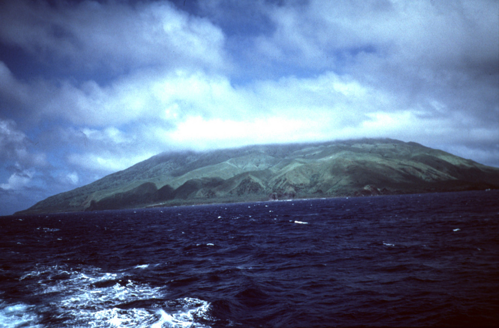
 Agrigan is the highest of the Marianas arc volcanoes, seen here from the south. The island is 8 km long and its summit is the top of a large 4-km-high submarine volcano. The summit caldera is 1 x 2 km wide and 500 m deep, and the vegetated flanks consist almost entirely of pyroclastic deposits that are more than 100 m thick on the SW flank.