
Avalanche moves 5 km down the uninhabited east flank on 20 October
A sizable rock avalanche occurred during 20 October on the E side of Mount Adams. Based on seismic signals, the avalanche began at 0031 and lasted about six minutes. There were no seismic precursors.
On 21 October, a US Geological Survey scientist inspected the avalanche deposit from a small airplane. The avalanche originated at ~3,500 m elevation on the S face of The Castle, a prominent topographic knob at the head of Battlement Ridge. The source area formed an obvious, near-vertical scar roughly triangular in shape with sides ~300 m long. The summit of The Castle remained intact. The avalanche descended the Klickitat Glacier icefall and left a thin veneer of rock debris on the steep upper part of the glacier. Below ~2,500 m elevation the deposit thickened. The avalanche traveled beyond the end of the Klickitat Glacier and continued ~2 km down the valley of Big Muddy Creek, a Klickitat River tributary. The length of the avalanche track totaled ~5 km, and the width may exceed 1 km in places. The average width is ~0.5 km. Maximum deposit thickness may exceed 20 m. The volume of the avalanche debris is probably between 1 and 5 million m3.
The avalanche deposit temporarily blocked the flow of Big Muddy Creek, resulting in the formation of a small lake on the avalanche debris. By noon on 21 October the avalanche dam had breached, and flow in Big Muddy Creek did not appear unusual. Continuing hazards exist due to the threat of additional rockfalls, damming and downstream flooding. However, these hazards exist primarily in unpopulated areas deep within the backcountry of Yakima Nation lands. No evidence suggests that hazards in populated areas far downstream have increased significantly.
This avalanche appeared unrelated to a similar-sized avalanche on the W flank of Mount Adams about seven weeks earlier (31 August). This earlier avalanche consisted of about 90% snow and ice; its source was Avalanche Glacier cirque at ~ 3,650-m elevation on the upper SW flank. Both avalanches originated where rocks evidently had been weakened by intense hydrothermal alteration. Both avalanches may have been triggered in part by wet subsurface conditions associated with late-season thawing of exceptionally heavy snowpack in conjunction with early-season storms. Neither avalanche was triggered by regional earthquake or volcanic activity.
After the 20 October avalanche, a second, smaller one swept down the same path and yielded a much smaller seismic signal that began at 0729 on 24 October. Preliminary reports suggested that the second avalanche traveled only about half the distance of the first.
Mount Adams, one of the largest volcanoes in the Cascade Range, dominates the Mount Adams volcanic field in Washington's Skamania, Yakima, Klickitat, and Lewis counties and the Yakima Indian Reservation of S-central Washington (1,250 km2). At Adams, large landslides and lahars that need not be related to eruptions probably pose the most destructive, far-reaching hazard.
Information Contacts: Cascades Volcano Observatory (CVO), U.S. Geological Survey, 5400 MacArthur Blvd., Vancouver, WA 98661, USA (URL: http://volcanoes.usgs.gov/); Geophysics Program, University of Washington, Seattle, WA 98195, USA (URL: https://volcanoes.usgs.gov/observatories/cvo/).
The Global Volcanism Program has no Weekly Reports available for Adams.
Reports are organized chronologically and indexed below by Month/Year (Publication Volume:Number), and include a one-line summary. Click on the index link or scroll down to read the reports.
Avalanche moves 5 km down the uninhabited east flank on 20 October
A sizable rock avalanche occurred during 20 October on the E side of Mount Adams. Based on seismic signals, the avalanche began at 0031 and lasted about six minutes. There were no seismic precursors.
On 21 October, a US Geological Survey scientist inspected the avalanche deposit from a small airplane. The avalanche originated at ~3,500 m elevation on the S face of The Castle, a prominent topographic knob at the head of Battlement Ridge. The source area formed an obvious, near-vertical scar roughly triangular in shape with sides ~300 m long. The summit of The Castle remained intact. The avalanche descended the Klickitat Glacier icefall and left a thin veneer of rock debris on the steep upper part of the glacier. Below ~2,500 m elevation the deposit thickened. The avalanche traveled beyond the end of the Klickitat Glacier and continued ~2 km down the valley of Big Muddy Creek, a Klickitat River tributary. The length of the avalanche track totaled ~5 km, and the width may exceed 1 km in places. The average width is ~0.5 km. Maximum deposit thickness may exceed 20 m. The volume of the avalanche debris is probably between 1 and 5 million m3.
The avalanche deposit temporarily blocked the flow of Big Muddy Creek, resulting in the formation of a small lake on the avalanche debris. By noon on 21 October the avalanche dam had breached, and flow in Big Muddy Creek did not appear unusual. Continuing hazards exist due to the threat of additional rockfalls, damming and downstream flooding. However, these hazards exist primarily in unpopulated areas deep within the backcountry of Yakima Nation lands. No evidence suggests that hazards in populated areas far downstream have increased significantly.
This avalanche appeared unrelated to a similar-sized avalanche on the W flank of Mount Adams about seven weeks earlier (31 August). This earlier avalanche consisted of about 90% snow and ice; its source was Avalanche Glacier cirque at ~ 3,650-m elevation on the upper SW flank. Both avalanches originated where rocks evidently had been weakened by intense hydrothermal alteration. Both avalanches may have been triggered in part by wet subsurface conditions associated with late-season thawing of exceptionally heavy snowpack in conjunction with early-season storms. Neither avalanche was triggered by regional earthquake or volcanic activity.
After the 20 October avalanche, a second, smaller one swept down the same path and yielded a much smaller seismic signal that began at 0729 on 24 October. Preliminary reports suggested that the second avalanche traveled only about half the distance of the first.
Mount Adams, one of the largest volcanoes in the Cascade Range, dominates the Mount Adams volcanic field in Washington's Skamania, Yakima, Klickitat, and Lewis counties and the Yakima Indian Reservation of S-central Washington (1,250 km2). At Adams, large landslides and lahars that need not be related to eruptions probably pose the most destructive, far-reaching hazard.
Information Contacts: Cascades Volcano Observatory (CVO), U.S. Geological Survey, 5400 MacArthur Blvd., Vancouver, WA 98661, USA (URL: http://volcanoes.usgs.gov/); Geophysics Program, University of Washington, Seattle, WA 98195, USA (URL: https://volcanoes.usgs.gov/observatories/cvo/).
This compilation of synonyms and subsidiary features may not be comprehensive. Features are organized into four major categories: Cones, Craters, Domes, and Thermal Features. Synonyms of features appear indented below the primary name. In some cases additional feature type, elevation, or location details are provided.
Synonyms |
||||
| Pahto | Paddo | ||||
Cones |
||||
| Feature Name | Feature Type | Elevation | Latitude | Longitude |
| Bunnell Butte | Pyroclastic cone | 46° 5' 0" N | 121° 27' 0" W | |
| Goat Butte | Pyroclastic cone | 2281 m | 46° 12' 28" N | 121° 25' 33" W |
| Little Mount Adams | Pyroclastic cone | 2079 m | 46° 10' 12" N | 121° 25' 7" W |
| Potato Hill | Pyroclastic cone | 46° 20' 0" N | 121° 30' 0" W | |
| Red Butte | Pyroclastic cone | 2196 m | 46° 14' 44" N | 121° 27' 34" W |
| Smith Butte | Pyroclastic cone | 46° 4' 0" N | 121° 28' 0" W | |
| Snipes Mountain | Pyroclastic cone | 46° 6' 0" N | 121° 28' 0" W | |
| South Butte | Pyroclastic cone | 2316 m | 46° 11' 0" N | 121° 29' 0" W |
Craters |
||||
| Feature Name | Feature Type | Elevation | Latitude | Longitude |
| King Mountain Fissure | Fissure vent | |||
|
|
||||||||||||||||||||||||||
There is data available for 15 confirmed Holocene eruptive periods.
0950 (?) Confirmed Eruption Max VEI: 2
| Episode 1 | Eruption Episode | East flank?, Tephra layer 24 | |||||||||||||||||||||||||||||
|---|---|---|---|---|---|---|---|---|---|---|---|---|---|---|---|---|---|---|---|---|---|---|---|---|---|---|---|---|---|---|
| 0950 (?) - Unknown | Evidence from Correlation: Tephrochronology | |||||||||||||||||||||||||||||
|
List of 4 Events for Episode 1 at East flank?, Tephra layer 24
| ||||||||||||||||||||||||||||||
0200 (?) Confirmed Eruption Max VEI: 2
| Episode 1 | Eruption Episode | Tephra layer 23 | ||||||||||||||||||||||||||||||||||
|---|---|---|---|---|---|---|---|---|---|---|---|---|---|---|---|---|---|---|---|---|---|---|---|---|---|---|---|---|---|---|---|---|---|---|---|
| 0200 (?) - Unknown | Evidence from Correlation: Tephrochronology | ||||||||||||||||||||||||||||||||||
|
List of 5 Events for Episode 1 at Tephra layer 23
| |||||||||||||||||||||||||||||||||||
0300 BCE (?) Confirmed Eruption Max VEI: 2
| Episode 1 | Eruption Episode | Tephra layer 22 | ||||||||||||||||||||||||
|---|---|---|---|---|---|---|---|---|---|---|---|---|---|---|---|---|---|---|---|---|---|---|---|---|---|
| 0300 BCE (?) - Unknown | Evidence from Correlation: Tephrochronology | ||||||||||||||||||||||||
|
List of 3 Events for Episode 1 at Tephra layer 22
| |||||||||||||||||||||||||
0400 BCE (?) Confirmed Eruption Max VEI: 2
| Episode 1 | Eruption Episode | Tephra layer 21 | ||||||||||||||||||||||||
|---|---|---|---|---|---|---|---|---|---|---|---|---|---|---|---|---|---|---|---|---|---|---|---|---|---|
| 0400 BCE (?) - Unknown | Evidence from Correlation: Tephrochronology | ||||||||||||||||||||||||
|
List of 3 Events for Episode 1 at Tephra layer 21
| |||||||||||||||||||||||||
0550 BCE ± 1000 years Confirmed Eruption Max VEI: 2
| Episode 1 | Eruption Episode | Tephra layers 19-20 | ||||||||||||||||||||||||||||||||||
|---|---|---|---|---|---|---|---|---|---|---|---|---|---|---|---|---|---|---|---|---|---|---|---|---|---|---|---|---|---|---|---|---|---|---|---|
| 0550 BCE ± 1000 years - Unknown | Evidence from Correlation: Tephrochronology | ||||||||||||||||||||||||||||||||||
|
List of 5 Events for Episode 1 at Tephra layers 19-20
| |||||||||||||||||||||||||||||||||||
1850 BCE (after) Confirmed Eruption Max VEI: 1 (?)
| Episode 1 | Eruption Episode | SSE flank (2100 m) | |||||||||||||||||||||||||||||
|---|---|---|---|---|---|---|---|---|---|---|---|---|---|---|---|---|---|---|---|---|---|---|---|---|---|---|---|---|---|---|
| 1850 BCE (after) - Unknown | Evidence from Correlation: Tephrochronology | |||||||||||||||||||||||||||||
|
List of 4 Events for Episode 1 at SSE flank (2100 m)
| ||||||||||||||||||||||||||||||
2650 BCE ± 300 years Confirmed Eruption Max VEI: 2
| Episode 1 | Eruption Episode | Tephra layers 17-18 | |||||||||||||||||||||||||||||
|---|---|---|---|---|---|---|---|---|---|---|---|---|---|---|---|---|---|---|---|---|---|---|---|---|---|---|---|---|---|---|
| 2650 BCE ± 300 years - Unknown | Evidence from Correlation: Tephrochronology | |||||||||||||||||||||||||||||
|
List of 4 Events for Episode 1 at Tephra layers 17-18
| ||||||||||||||||||||||||||||||
2950 BCE ± 100 years Confirmed Eruption Max VEI: 1 (?)
| Episode 1 | Eruption Episode | SSE flank (2600 m), Tephra layer 16 | ||||||||||||||||||||||||||||||||||
|---|---|---|---|---|---|---|---|---|---|---|---|---|---|---|---|---|---|---|---|---|---|---|---|---|---|---|---|---|---|---|---|---|---|---|---|
| 2950 BCE ± 100 years - Unknown | Evidence from Correlation: Tephrochronology | ||||||||||||||||||||||||||||||||||
|
List of 5 Events for Episode 1 at SSE flank (2600 m), Tephra layer 16
| |||||||||||||||||||||||||||||||||||
3250 BCE ± 300 years Confirmed Eruption Max VEI: 2
| Episode 1 | Eruption Episode | Tephra layer 15 | ||||||||||||||||||||||||||||||||||
|---|---|---|---|---|---|---|---|---|---|---|---|---|---|---|---|---|---|---|---|---|---|---|---|---|---|---|---|---|---|---|---|---|---|---|---|
| 3250 BCE ± 300 years - Unknown | Evidence from Correlation: Tephrochronology | ||||||||||||||||||||||||||||||||||
|
List of 5 Events for Episode 1 at Tephra layer 15
| |||||||||||||||||||||||||||||||||||
3550 BCE (?) Confirmed Eruption Max VEI: 2
| Episode 1 | Eruption Episode | Tephra layer 14 | |||||||||||||||||||||||||||||
|---|---|---|---|---|---|---|---|---|---|---|---|---|---|---|---|---|---|---|---|---|---|---|---|---|---|---|---|---|---|---|
| 3550 BCE (?) - Unknown | Evidence from Correlation: Tephrochronology | |||||||||||||||||||||||||||||
|
List of 4 Events for Episode 1 at Tephra layer 14
| ||||||||||||||||||||||||||||||
3800 BCE ± 1950 years Confirmed Eruption Max VEI: 1 (?)
| Episode 1 | Eruption Episode | NNE flank (2100-2250 m) | |||||||||||||||||||||||||||||
|---|---|---|---|---|---|---|---|---|---|---|---|---|---|---|---|---|---|---|---|---|---|---|---|---|---|---|---|---|---|---|
| 3800 BCE ± 1950 years - Unknown | Evidence from Correlation: Tephrochronology | |||||||||||||||||||||||||||||
|
List of 4 Events for Episode 1 at NNE flank (2100-2250 m)
| ||||||||||||||||||||||||||||||
4050 BCE ± 500 years Confirmed Eruption Max VEI: 2
| Episode 1 | Eruption Episode | Upper SW flank?, Tephra layers 11-13 | ||||||||||||||||||||||||||||||||||||||||||||
|---|---|---|---|---|---|---|---|---|---|---|---|---|---|---|---|---|---|---|---|---|---|---|---|---|---|---|---|---|---|---|---|---|---|---|---|---|---|---|---|---|---|---|---|---|---|
| 4050 BCE ± 500 years - Unknown | Evidence from Correlation: Tephrochronology | ||||||||||||||||||||||||||||||||||||||||||||
|
List of 7 Events for Episode 1 at Upper SW flank?, Tephra layers 11-13
| |||||||||||||||||||||||||||||||||||||||||||||
4550 BCE (?) Confirmed Eruption Max VEI: 2
| Episode 1 | Eruption Episode | NW flank (2200-2400 m), Tephra layer 10 | |||||||||||||||||||||||||||||||||||||||
|---|---|---|---|---|---|---|---|---|---|---|---|---|---|---|---|---|---|---|---|---|---|---|---|---|---|---|---|---|---|---|---|---|---|---|---|---|---|---|---|---|
| 4550 BCE (?) - Unknown | Evidence from Correlation: Tephrochronology | |||||||||||||||||||||||||||||||||||||||
|
List of 6 Events for Episode 1 at NW flank (2200-2400 m), Tephra layer 10
| ||||||||||||||||||||||||||||||||||||||||
5150 BCE ± 500 years Confirmed Eruption Max VEI: 2
| Episode 1 | Eruption Episode | Tephra layers 5-9 | ||||||||||||||||||||||||||||||||||
|---|---|---|---|---|---|---|---|---|---|---|---|---|---|---|---|---|---|---|---|---|---|---|---|---|---|---|---|---|---|---|---|---|---|---|---|
| 5150 BCE ± 500 years - Unknown | Evidence from Correlation: Tephrochronology | ||||||||||||||||||||||||||||||||||
|
List of 5 Events for Episode 1 at Tephra layers 5-9
| |||||||||||||||||||||||||||||||||||
7050 BCE ± 1000 years Confirmed Eruption Max VEI: 2
| Episode 1 | Eruption Episode | Tephra layers 1-4 | |||||||||||||||||||||||||||||
|---|---|---|---|---|---|---|---|---|---|---|---|---|---|---|---|---|---|---|---|---|---|---|---|---|---|---|---|---|---|---|
| 7050 BCE ± 1000 years - Unknown | Evidence from Correlation: Tephrochronology | |||||||||||||||||||||||||||||
|
List of 4 Events for Episode 1 at Tephra layers 1-4
| ||||||||||||||||||||||||||||||
There is no Deformation History data available for Adams.
There is no Emissions History data available for Adams.
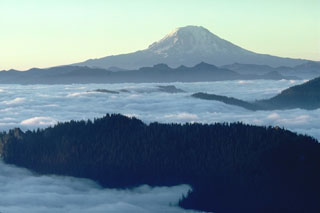 Mount Adams in the Cascade Range is seen here in 1981 from High Knob to the NW. Its base is at a lower elevation than its neighbor Mount Rainier and it has a larger volume. Numerous flank vents surround the volcano and a series of lava flows have erupted on the N, NW, S and E flanks.
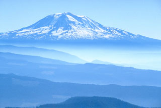 Mount Adams is seen in this view from Mount St. Helens to the west. Eruptive activity continued into the Holocene from both summit and vents on the N, NW, S and E flanks.
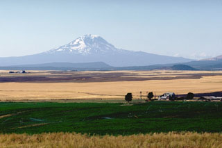 Mount Adams is seen here beyond farmlands on the east side of the Cascades. Mount Adams, known to local tribes as Pahto or Klickitat, featured prominently in tribal legends. The summit was said to have been flattened by a mighty blow from its southern brother, Mount Hood (Wyeast), when the damsel St. Helens (La-wa-la-clough) preferred Adams over Hood.
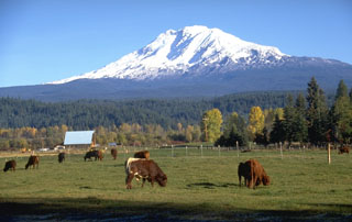 The farmlands of the Trout Lake valley SW of Mount Adams are underlain by a massive lahar produced by collapse of the upper SW flank of Adams about 6,000 years ago. Altered rocks up to several meters in diameter that originated from near the summit of the volcano littered the surface of the deposit, which covered 15 km2 of the Trout Lake lowland and reached as far as 60 km to the south. The source of the mudflow was a debris avalanche from the upper White Salmon glacier area, just left of the shadow beneath the summit.
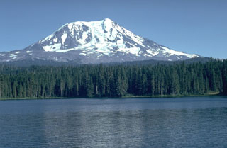 Adams Glacier descends from the summit of Mount Adams, seen here above Takhlakh Lake on the NW side. The main edifice was constructed primarily of lava flows during the Pleistocene, but flank vents produced lava flows and explosive eruptions during the Holocene. The Takh Takh Meadow lava flow originated from a vent low on the NW flank and traveled a total of 10 km, reaching several kilometers beyond the east (left) side of Takhlakh Lake.
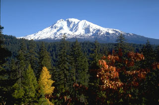 Mount Adams in the southern Cascade Range of Washington in seen from the SW in this view. The large cirque below the left side of the summit is occupied by the White Salmon and Avalanche Glaciers and was the source of a large mudflow that traveled 60 km down the White Salmon River valley about 6,000 years ago.
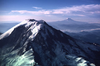 This view of Mount Rainier from the NW shows neighboring Mount Adams to the right in 1985. The steep Willis Wall, named after the 19th-century geologist Bailey Willis, is to the left and exposes relatively young lava flows.
 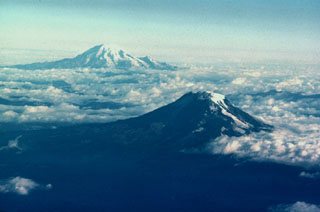 Mount Adams (lower right) and Mount Rainier are the two southernmost of a N-S-trending chain of large stratovolcanoes in the Cascade Range of Washington state. Adams Glacier can be seen descending to the SE from the summit icecap of Mount Adams in this aerial view from the south. The 1,250 km2 Mount Adams volcanic field contains numerous flank cones and lava flows, several of which erupted during the Holocene. Mount Rainier, Washington's highest peak, has been less active during the Holocene, but erupted during the 19th century.
The maps shown below have been scanned from the GVP map archives and include the volcano on this page. Clicking on the small images will load the full 300 dpi map. Very small-scale maps (such as world maps) are not included. The maps database originated over 30 years ago, but was only recently updated and connected to our main database. We welcome users to tell us if they see incorrect information or other problems with the maps; please use the Contact GVP link at the bottom of the page to send us email.
The following 18 samples associated with this volcano can be found in the Smithsonian's NMNH Department of Mineral Sciences collections, and may be availble for research (contact the Rock and Ore Collections Manager). Catalog number links will open a window with more information.
| Catalog Number | Sample Description | Lava Source | Collection Date |
|---|---|---|---|
| NMNH 116133-1 | Scoria | -- | -- |
| NMNH 116133-2 | Andesite | -- | -- |
| NMNH 116133-3 | Andesite | -- | -- |
| NMNH 116133-4 | Andesite | -- | -- |
| NMNH 116133-5 | Andesite | -- | -- |
| NMNH 116133-6 | Andesite | -- | -- |
| NMNH 116133-7 | Basalt (?) | -- | -- |
| NMNH 116133-8 | Scoria | POTATO HILL | -- |
| NMNH 117254-1 | Eclogite | -- | -- |
| NMNH 117254-10 | Actinolite Schist | -- | -- |
| NMNH 117254-2 | Eclogite | -- | -- |
| NMNH 117254-3 | Eclogite | -- | -- |
| NMNH 117254-4 | Eclogite | -- | -- |
| NMNH 117254-5 | Eclogite | -- | -- |
| NMNH 117254-6 | Eclogite | -- | -- |
| NMNH 117254-7 | Eclogite | -- | -- |
| NMNH 117254-8 | Eclogite | -- | -- |
| NMNH 117254-9 | Eclogite | -- | -- |
| Copernicus Browser | The Copernicus Browser replaced the Sentinel Hub Playground browser in 2023, to provide access to Earth observation archives from the Copernicus Data Space Ecosystem, the main distribution platform for data from the EU Copernicus missions. |
| MIROVA | Middle InfraRed Observation of Volcanic Activity (MIROVA) is a near real time volcanic hot-spot detection system based on the analysis of MODIS (Moderate Resolution Imaging Spectroradiometer) data. In particular, MIROVA uses the Middle InfraRed Radiation (MIR), measured over target volcanoes, in order to detect, locate and measure the heat radiation sourced from volcanic activity. |
| MODVOLC Thermal Alerts | Using infrared satellite Moderate Resolution Imaging Spectroradiometer (MODIS) data, scientists at the Hawai'i Institute of Geophysics and Planetology, University of Hawai'i, developed an automated system called MODVOLC to map thermal hot-spots in near real time. For each MODIS image, the algorithm automatically scans each 1 km pixel within it to check for high-temperature hot-spots. When one is found the date, time, location, and intensity are recorded. MODIS looks at every square km of the Earth every 48 hours, once during the day and once during the night, and the presence of two MODIS sensors in space allows at least four hot-spot observations every two days. Each day updated global maps are compiled to display the locations of all hot spots detected in the previous 24 hours. There is a drop-down list with volcano names which allow users to 'zoom-in' and examine the distribution of hot-spots at a variety of spatial scales. |
|
WOVOdat
Single Volcano View Temporal Evolution of Unrest Side by Side Volcanoes |
WOVOdat is a database of volcanic unrest; instrumentally and visually recorded changes in seismicity, ground deformation, gas emission, and other parameters from their normal baselines. It is sponsored by the World Organization of Volcano Observatories (WOVO) and presently hosted at the Earth Observatory of Singapore.
GVMID Data on Volcano Monitoring Infrastructure The Global Volcano Monitoring Infrastructure Database GVMID, is aimed at documenting and improving capabilities of volcano monitoring from the ground and space. GVMID should provide a snapshot and baseline view of the techniques and instrumentation that are in place at various volcanoes, which can be use by volcano observatories as reference to setup new monitoring system or improving networks at a specific volcano. These data will allow identification of what monitoring gaps exist, which can be then targeted by remote sensing infrastructure and future instrument deployments. |
| Volcanic Hazard Maps | The IAVCEI Commission on Volcanic Hazards and Risk has a Volcanic Hazard Maps database designed to serve as a resource for hazard mappers (or other interested parties) to explore how common issues in hazard map development have been addressed at different volcanoes, in different countries, for different hazards, and for different intended audiences. In addition to the comprehensive, searchable Volcanic Hazard Maps Database, this website contains information about diversity of volcanic hazard maps, illustrated using examples from the database. This site is for educational purposes related to volcanic hazard maps. Hazard maps found on this website should not be used for emergency purposes. For the most recent, official hazard map for a particular volcano, please seek out the proper institutional authorities on the matter. |
| IRIS seismic stations/networks | Incorporated Research Institutions for Seismology (IRIS) Data Services map showing the location of seismic stations from all available networks (permanent or temporary) within a radius of 0.18° (about 20 km at mid-latitudes) from the given location of Adams. Users can customize a variety of filters and options in the left panel. Note that if there are no stations are known the map will default to show the entire world with a "No data matched request" error notice. |
| UNAVCO GPS/GNSS stations | Geodetic Data Services map from UNAVCO showing the location of GPS/GNSS stations from all available networks (permanent or temporary) within a radius of 20 km from the given location of Adams. Users can customize the data search based on station or network names, location, and time window. Requires Adobe Flash Player. |
| DECADE Data | The DECADE portal, still in the developmental stage, serves as an example of the proposed interoperability between The Smithsonian Institution's Global Volcanism Program, the Mapping Gas Emissions (MaGa) Database, and the EarthChem Geochemical Portal. The Deep Earth Carbon Degassing (DECADE) initiative seeks to use new and established technologies to determine accurate global fluxes of volcanic CO2 to the atmosphere, but installing CO2 monitoring networks on 20 of the world's 150 most actively degassing volcanoes. The group uses related laboratory-based studies (direct gas sampling and analysis, melt inclusions) to provide new data for direct degassing of deep earth carbon to the atmosphere. |
| Large Eruptions of Adams | Information about large Quaternary eruptions (VEI >= 4) is cataloged in the Large Magnitude Explosive Volcanic Eruptions (LaMEVE) database of the Volcano Global Risk Identification and Analysis Project (VOGRIPA). |
| EarthChem | EarthChem develops and maintains databases, software, and services that support the preservation, discovery, access and analysis of geochemical data, and facilitate their integration with the broad array of other available earth science parameters. EarthChem is operated by a joint team of disciplinary scientists, data scientists, data managers and information technology developers who are part of the NSF-funded data facility Integrated Earth Data Applications (IEDA). IEDA is a collaborative effort of EarthChem and the Marine Geoscience Data System (MGDS). |

