Slight temperature increases at most summit fumaroles and hot springs
Logistical support from the Méxican Navy enabled researchers to measure seven fumarole and hot spring temperatures on 2 February 1995 in the summit region of Socorro Island's Mount Everman. Previous measurements, taken on 5-12 February 1993, were made at the same sites. These sites, labeled A-G, are shown on sketch maps and tables in Siebe and others (1995) and BGVN 18:01. In this most recent series of measurements, all temperatures were 90°C, except site D, which was 74°C. The 1993 measurements were made in conjunction with a local submarine eruption that also produced T-wave signals. These new measurements showed a several-degree increase over many of those in 1993.
The 1993 eruption was seen at the ocean surface over the island's submarine W flanks; during this visit further signs of eruption were absent from the ocean's surface and from distant hydrophones. Unfortunately, local hydrophones on the S end of the island were not operational. Several hundred meters N of the summit, on North Dome, the visitors saw recently killed vegetation and dead trees on the margins of some hydrothermally active pits. They also noted soft warm ground, dead bracken, and newly established pits, suggesting reactivation. In other cases green trees grew in the pit walls. While the majority of the fumaroles appeared similar to those in 1993, the observers noted three 'mud volcanoes'; two were active and the third issued deep rumblings. A stream in the vicinity of the summit and North Dome had a temperature of 60°C and numerous 80°C springs were seen both along its bed and nearby.
Reference. Siebe, C., Komorowski, J-C., Navarro, C., McHone, J., Delgado, H., and Cortes, A., 1995, Submarine eruption near Socorro Island, Mexico: Geochemistry and scanning electron microscope studies of floating scoria and reticulite: Journal of Volcanology and Geothermal Research, v. 68, p. 239-71.
Information Contacts: Andrew M. Burton, OCEAN, Organizatión para la Conservación Estudio y Análisis de la Naturaleza, A.C., 22 de Diciembre No. 1, Col. Manuel Avila Camancho, Naucalpan, Edo. de México.
The Global Volcanism Program has no Weekly Reports available for Socorro.
Reports are organized chronologically and indexed below by Month/Year (Publication Volume:Number), and include a one-line summary. Click on the index link or scroll down to read the reports.
Vesicular lava eruption from underwater vent W of the island
Eruptive activity at Socorro Island (figure 1) was first observed at 1745 on 29 January 2.4 km NW of Punta Tosca (figure 2) by underwater photographers aboard the "Mystique." When the boat approached a steam column, they observed hot, dark-colored rocks ~1-3 m across breaking the surface in an area of ~50 m2. Depending on the specific block, there was production of hissing noises, steam, jets of white vapor several meters high, violent fracturing, or fragmentation that sent clasts to 50 m height. No explosive activity or volcanic plume was observed. Depending on vesicularity, blocks either sank or floated; floating rocks covered an area of ~6,000 m2 by 31 January. Depth soundings gave depths of 138-149 m in an area where a large number of gas bubbles were being generated, presumably by degassing of rising lava clasts. Activity had decreased by 3 February, when only eight blocks were seen at the surface, but the Mystique reported that activity fluctuated during the day and between days. Another depth sounding recorded a depth of 519 m.
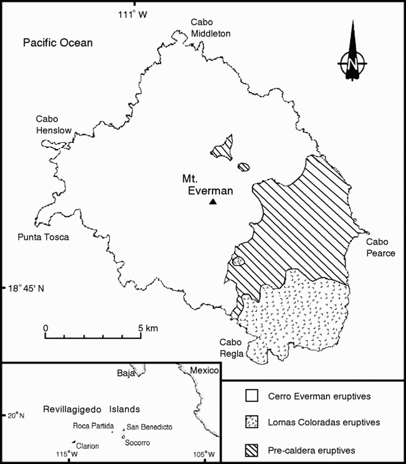 |
Figure 1. Location map and general geologic map of Socorro Island showing three major eruptive units (from Bryan, 1966 and 1976). |
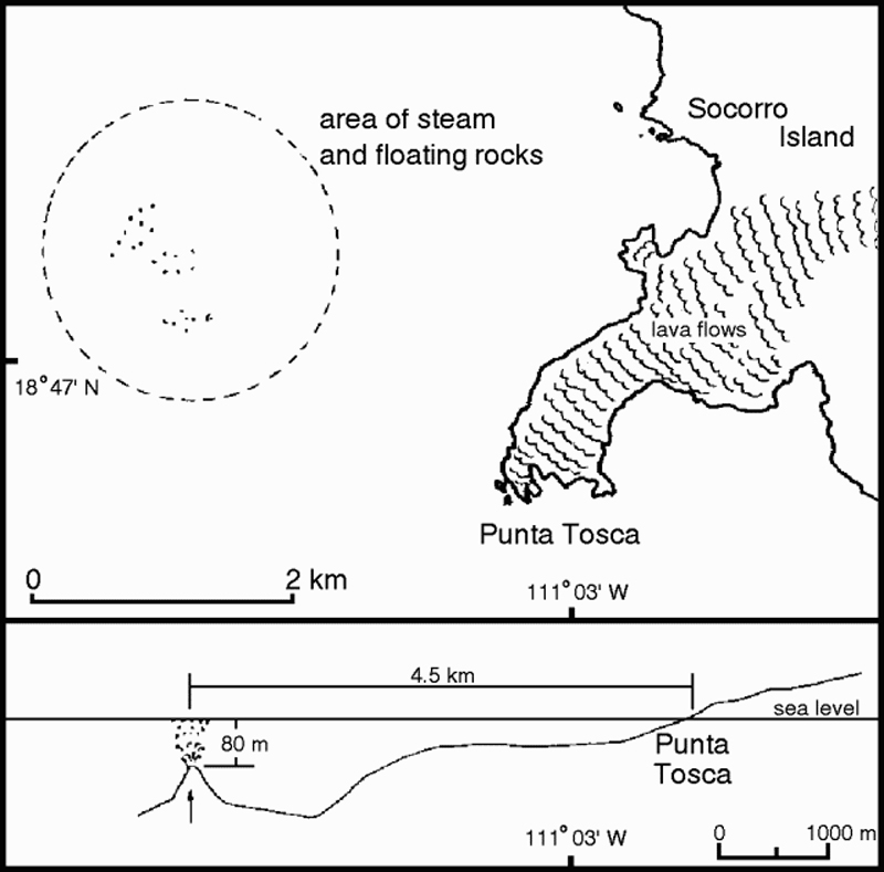 |
Figure 2. Sketch map and interpretive cross-section of the SW part of Socorro Island with location of submarine activity W of Punta Tosca. Courtesy of Ignacio Galindo. |
Juvenile material collected by Mystique divers is described by geologists as black to greenish, semi-translucent, highly vesiculated glass with vesicles up to 5-10 cm in diameter and abundant large (10-15 mm) gray tabular plagioclase phenocrysts.
Activity observed by geologists on 4 February (1245-1700) had a radius of about 1 km, centered at 18.81°N, 111.08°W, about 3.14 km from Punta Tosca and 4.63 km from Cape Henslow on Socorro Island. Water depth, determined by echo-sounding, was 80 m about 200 m SE from the most active area, and rapidly increased to more than 200 m travelling E towards the island. Although the data is only an approximation due to the difficulty of approaching the vent area, a sharp rise in the ocean-floor topography below the most active area is indicated. Very hot scoriaceous lava blocks, ranging in size from several centimeters to 2-3 m, were observed quickly rising to the surface and producing activity similar to that described earlier. Blocks then either floated away or sank, with some being propelled along the surface by steam and effervescence. The vent area was difficult to precisely locate because of strong wind and waves causing the blocks to drift. Most of the time, three distinct and separate areas were observed, somewhat aligned, where the majority of lava fragments were rising. Seawater temperature was normal, but a light sulfurous odor was detected. A helicopter inspection from 1815-1835 observed an accumulation of blocks below the surface from which large (up to 5 m) blocks detached and rose to the surface. Some type of spine from which blocks were being released was confirmed by an overflight about 15 m above the surface.
A helicopter reconnaissance flight the next day (1005-1059) observed activity similar to previous days. About 100 rocks could be seen at any one time during 20 minutes of overflight at 5-10 m above the surface, and there was a strong sulfurous odor. New fragments continuously rose to the surface with a trail of bubbles in two distinct areas about 100 m apart. Wind and waves again made it difficult to define the vent area. Elongated bands of fine gray solid matter floating on the surface, observed from higher altitudes, are interpreted as finely fragmented suspended scoria. There was no evidence of juvenile material accumulating close to the surface or above it. Another helicopter flight that afternoon did not observe any evidence of hot floating scoriaceous rocks. Reports from Naval personnel based on visual observations from the sea and air indicate continued submarine activity through 17 February, but no accumulation of material above the surface.
The summit fumarole area of Everman volcano on Socorro Island exhibited no unusual activity during a 5 February visit. The summit lava dome complex, composed of abundant obsidian and other less vitric lavas, did not contain any fumaroles. However, below the summit to the NNE and NW, there are fumaroles at the base of a relatively young lava dome (figure 3), which appears to be the most recent feature in the summit area. The younger dome, which has obsidian margins, appears to have filled an older crater in a depression about 100 m below the summit to the N. The most active area is on the SE side of the N dome along an apparent zone of weakness with cracks to 1 m deep and 1 m wide. This zone includes areas of vapor, boiling water or mud, clay alteration, sulfates, and sulfur encrustations. Temperature measurements were taken at the major fumaroles (table 1). The largest and most continuously active fumarole produced a hissing sound. Water samples from a hotspring near fumarole F were obtained for analysis. An older dome SE of the summit also has some very small fumaroles. Overall, vapor emissions in the summit area do not seem uncommon for an active volcano.
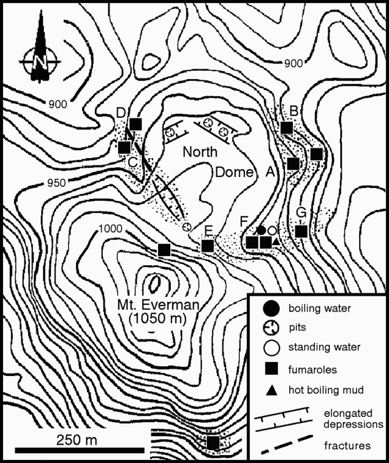 |
Figure 3. Topographic map of the summit of Everman volcano, Socorro Island, with location of major monitored fumaroles, and major structural features of the N lava dome. Light stipling indicates areas with intense fumarolic activity and hydrothermal alteration. |
Table 1. Temperatures (°C) measured in fumaroles in the summit area of Everman volcano, Socorro Island. All temperatures are thermocouple readings, except for location D, which was measured with a calibrated mercury thermometer. Location F contained several fumaroles and associated hydrothermal phenomena.
| Date | A | B | C | D | E | F | G |
| 05 Feb 1993 | -- | -- | -- | -- | -- | 95-101 | 93-97 |
| 06 Feb 1993 | 77 | 76 | 75-84 | 61 | 74 | 73-75 | -- |
| 09 Feb 1993 | 83 | 80 | 77 | 62 | 80 | 75-77 | 76 |
| 12 Feb 1993 | 79 | 81 | 78 | 85 | 84 | 81-89 | 83 |
Precursors were first recorded on 19 January, when an unusual clustering of randomly distributed impulsive hydroacoustic signals (T-phases) was observed on recordings from SOFAR channel hydrophones located near the island of Oahu, Hawaii. The T-phases were accompanied by elevated levels of background noise. Activity intensified at about 1000 GMT, and lasted approximately 1 hour. Based on the strongest phases recorded in Hawaii and at the LDG in Tahiti, the source was located near Socorro Island. Seismicity was felt by Mexican naval authorities on the island beginning on 16 January. A portable MQ-800 seismometer was installed on 4 February at the naval base on the island.
Socorro Island is located ~716 km W of Manzanillo, Colima, and 480 km S of the tip of Baja California. Tectonically, it is located within a segment of the southernmost region of the East Pacific Rise, S of the Riverra Fracture Zone. Eruptions have been reported in 1848, 1896, 1905, and 22 May 1951, but there are no clear details about the eruptions or their effects. The island is a compositionally diverse volcanic complex that rises about 4,000 m from the surrounding ocean floor. Based on recent 40Ar/39Ar dating, the surface is estimated to be 540 Ka old. The youngest reported age, from a lava flow on the S side of the island, is about 15 Ka, but probably does not represent the youngest unit. There are about 60 men, stationed at the Mexican National Navy base, living on the island.
References. Bryan, W. B., 1966, History and mechanism of eruption of soda-rhyolite and alkali basalt, Socorro Island, Mexico: Bulletin of Volcanology, v. 29, p. 453-479.
Bryan, W. B., 1976, A basalt-pantellerite association from Isla Socorro, Islas Revillagigedo, Mexico, in Volcanoes and Tectonosphere, H. Aoki, and S. Iizuka, eds., p. 75-91.
Information Contacts: Gustavo Calderón, Instituto de Oceanografía de Manzanillo, Las Brisas, Manzanillo, Colima, México; Ignacio Galindo, Carlos Navarro, and AbelCortés, CUICT, Univ de Colima, Apartado Postal 380, CP 2800, Colima, México; Jean-ChristopheKomorowski, ClausSiebe, and HugoDelgado, Instituto de Geofísica, UNAM, Coyoacán, 04510, México DF, México; BillChadwick, ChrisFox, and BobEmbley, NOAA, 2115 SE Osu Drive, Newport, OR 97365 USA; Charles S. McCreery and Daniel A. Walker, Univ of Hawaii at Manoa, Hawaii Institute of Geophysics, 2525 Correa Road, Honolulu, HI 96822 USA; J. Talandier, LDG Tahiti; Wendy Bohrson, Dept of Earth & Space Sciences, UCLA, 595 Circle Drive East, Geology Bldg., Room 3806, Los Angeles, CA 90024 USA; Bob Talbot and Charlie Peck, Bob Talbot Productions, P.O. Box 3126, Rancho Palos Verdes, CA 90274 USA.
Slight temperature increases at most summit fumaroles and hot springs
Logistical support from the Méxican Navy enabled researchers to measure seven fumarole and hot spring temperatures on 2 February 1995 in the summit region of Socorro Island's Mount Everman. Previous measurements, taken on 5-12 February 1993, were made at the same sites. These sites, labeled A-G, are shown on sketch maps and tables in Siebe and others (1995) and BGVN 18:01. In this most recent series of measurements, all temperatures were 90°C, except site D, which was 74°C. The 1993 measurements were made in conjunction with a local submarine eruption that also produced T-wave signals. These new measurements showed a several-degree increase over many of those in 1993.
The 1993 eruption was seen at the ocean surface over the island's submarine W flanks; during this visit further signs of eruption were absent from the ocean's surface and from distant hydrophones. Unfortunately, local hydrophones on the S end of the island were not operational. Several hundred meters N of the summit, on North Dome, the visitors saw recently killed vegetation and dead trees on the margins of some hydrothermally active pits. They also noted soft warm ground, dead bracken, and newly established pits, suggesting reactivation. In other cases green trees grew in the pit walls. While the majority of the fumaroles appeared similar to those in 1993, the observers noted three 'mud volcanoes'; two were active and the third issued deep rumblings. A stream in the vicinity of the summit and North Dome had a temperature of 60°C and numerous 80°C springs were seen both along its bed and nearby.
Reference. Siebe, C., Komorowski, J-C., Navarro, C., McHone, J., Delgado, H., and Cortes, A., 1995, Submarine eruption near Socorro Island, Mexico: Geochemistry and scanning electron microscope studies of floating scoria and reticulite: Journal of Volcanology and Geothermal Research, v. 68, p. 239-71.
Information Contacts: Andrew M. Burton, OCEAN, Organizatión para la Conservación Estudio y Análisis de la Naturaleza, A.C., 22 de Diciembre No. 1, Col. Manuel Avila Camancho, Naucalpan, Edo. de México.
This compilation of synonyms and subsidiary features may not be comprehensive. Features are organized into four major categories: Cones, Craters, Domes, and Thermal Features. Synonyms of features appear indented below the primary name. In some cases additional feature type, elevation, or location details are provided.
Cones |
||||
| Feature Name | Feature Type | Elevation | Latitude | Longitude |
| Coloradas, Lomas | Pyroclastic cone | |||
| Evermann, Cerro | Stratovolcano | 18° 47' 0" N | 110° 56' 0" W | |
Domes |
||||
| Feature Name | Feature Type | Elevation | Latitude | Longitude |
| Punta Tosca | Dome | |||
|
|
||||||||||||||||||||||||
There is data available for 3 confirmed Holocene eruptive periods.
1993 Jan 29 - 1994 Feb 24 ± 4 days Confirmed Eruption Max VEI: 0
| Episode 1 | Eruption Episode | Submarine vent 3 km W of Punta Tosca | |||||||||||||||||||
|---|---|---|---|---|---|---|---|---|---|---|---|---|---|---|---|---|---|---|---|---|
| 1993 Jan 29 - 1994 Feb 24 ± 4 days | Evidence from Observations: Reported | |||||||||||||||||||
|
List of 2 Events for Episode 1 at Submarine vent 3 km W of Punta Tosca
| ||||||||||||||||||||
1951 May 22 - 1951 May 22 Confirmed Eruption Max VEI: 2 (?)
| Episode 1 | Eruption Episode | SW flank (west of Lomas Coloradas) | ||||||||||||||||||||||||
|---|---|---|---|---|---|---|---|---|---|---|---|---|---|---|---|---|---|---|---|---|---|---|---|---|---|
| 1951 May 22 - 1951 May 22 | Evidence from Observations: Reported | ||||||||||||||||||||||||
|
List of 3 Events for Episode 1 at SW flank (west of Lomas Coloradas)
| |||||||||||||||||||||||||
[ 1905 Jan ] Uncertain Eruption
| Episode 1 | Eruption Episode | ||||||||||||||||||||
|---|---|---|---|---|---|---|---|---|---|---|---|---|---|---|---|---|---|---|---|---|
| 1905 Jan - Unknown | Evidence from Unknown | |||||||||||||||||||
|
List of 2 Events for Episode 1
| ||||||||||||||||||||
[ 1896 ] Uncertain Eruption
| Episode 1 | Eruption Episode | |||||||||||||||
|---|---|---|---|---|---|---|---|---|---|---|---|---|---|---|---|
| 1896 - Unknown | Evidence from Unknown | ||||||||||||||
|
List of 1 Events for Episode 1
| |||||||||||||||
[ 1848 ] Uncertain Eruption
| Episode 1 | Eruption Episode | |||||||||||||||
|---|---|---|---|---|---|---|---|---|---|---|---|---|---|---|---|
| 1848 - Unknown | Evidence from Unknown | ||||||||||||||
|
List of 1 Events for Episode 1
| |||||||||||||||
3090 BCE ± 500 years Confirmed Eruption
| Episode 1 | Eruption Episode | Lower SW flank (near Bahia Braithwaite) | ||||||||||||||||||||||||
|---|---|---|---|---|---|---|---|---|---|---|---|---|---|---|---|---|---|---|---|---|---|---|---|---|---|
| 3090 BCE ± 500 years - Unknown | Evidence from Isotopic: 14C (uncalibrated) | ||||||||||||||||||||||||
|
List of 3 Events for Episode 1 at Lower SW flank (near Bahia Braithwaite)
| |||||||||||||||||||||||||
There is no Deformation History data available for Socorro.
There is no Emissions History data available for Socorro.
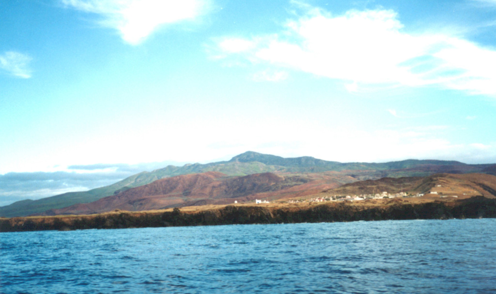
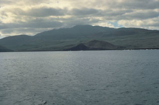 Socorro Island is the summit of a predominantly submarine shield volcano that has a largely buried 4.5-km-wide summit caldera. Cerro Evermann (center) forms the summit and is seen here from the south. Rhyolite lava domes have formed along flank rifts and silicic lava flows have reached the coast. Historical eruptions have been restricted to flank vents, including a submarine vent west of Socorro during 1993-94.
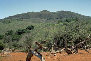 Cerro Evermann is a large cone and lava dome complex that forms the summit of Socorro. It, along with other cones and lava domes, largely fill a 3.8 x 4.5 km caldera at the summit of a shield volcano. Historical eruptions have been restricted to flank vents.
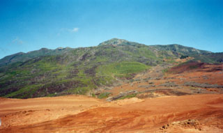 The summit cone and lava dome complex of Cerro Evermann is viewed here from the SE flank. Obsidian lava domes and flows of rhyolite and trachyte composition have filled most of the summit craters. Cerro Evermann formed within the 4.5 x 3.8-km-wide, 370,000 year old Pleistocene caldera. The caldera rim is exposed at about 600 m elevation on the south and east sides of Cerro Evermann, where it forms a 20-50 m high scarp.
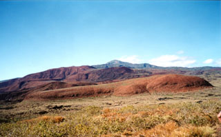 The southern flank of Socorro is underlain by rocks of three distinct origins. On the lower flanks are basaltic rocks of the Lomas Coloradas unit that mostly erupted between about 150,000 and 70,000 years ago. The middle flanks contain trachyte and rhyolite pyroclastic flow deposits that were emplaced between about 540,000 and 370,000 years ago. The summit region, including Cerro Evermann (center horizon), consists of silicic rocks that were erupted between about 180,000 to at least 15,000 years ago.
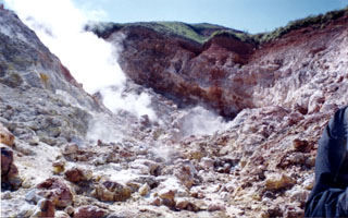 Hydrothermal alteration is extensive within the valley walls of a thermal area near the summit of Cerro Evermann. Gases rise from fumaroles in this 1998 view. The largest fumarolic vent is located at the head of a large barranca NE of the summit. During a 1957 visit by Mooser and Bryan, temperatures of 65-97°C were measured. Similar temperatures ranging from 61-101°C were measured in 1993.
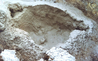 Mudpots are found at hydrothermal areas near the summit of Cerro Evermann. Fumaroles are active at the base of a relatively young lava dome, which is one of the youngest features of the summit area. The most active area is on the SE side of a northern dome and includes areas of emissions, boiling water or mud, clay alteration, and sulfur deposits.
 Cerro Evermann, the high point of Socorro Island, rises above a Mexican Naval camp near the southern tip of the island. Socorro lies in the Revillagigedo Islands south of Baja California. Cerro Evermann is a cone and lava dome complex that forms the summit. Rhyolite lava domes have formed along flank rifts, and silicic lava flows that were erupted from summit and flank vents have created an irregular shoreline.
 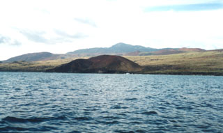 This cone lies along the SSE coast of Socorro Island, east of Cabo Rule (also known as Cabo Regla). The peak on the center horizon is Cerro Evermann, the high point of the island. Basaltic cones and lava flows of the Lomas Coloradas formation blanket the southern tip of the island. Although 80% of the surface of the island is covered by silicic post-caldera lava domes and flows and few pre-caldera rocks are exposed, the bulk of the Socorro shield volcano is considered to be composed of basaltic deposits.
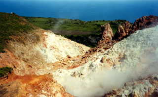 Fumarolic areas at Socorro are concentrated near the summit of Cerro Evermann. They occur on all sides of North Dome, a young lava dome just to the north. The most extensive hydrothermal alteration is located in areas on the E, W, and SW sides of North Dome.
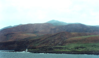 The northern, western, and southern flanks of Socorro are dominated by silicic lava domes and flows, which cover about 80% of the surface of the island. This view shows Cerro Evermann from the SW coast. Trachyte and rhyolite lava flows from summit and flank vents extend into the sea and have produced an irregular shoreline, with the distal portions of lava flows forming numerous small peninsulas.
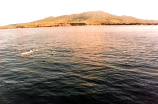 Trails of steam in the foreground rise from floating scoriaceous clasts during a submarine eruption off the west coast of Socorro Island in 1993. The eruption, from vents about 3 km NW of Punta Tosca, was first observed 29 January 1993 following ten days of SOFAR (SOund Fixing And Ranging) signals recorded in Hawaii. Large scoriaceous clasts up to 5 m in size floated to the surface without associated explosive activity. Floating masses of hot scoria were erupted until at least the end of February 1994.
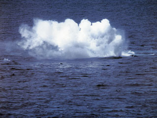 During a submarine eruption that was first observed on 29 January 1993, small explosions were produced when floating hot rocks fractured and their hot interiors came in contact with sea water. Large blocks of dark-gray, highly-vesiculated basalt up to 5 m in diameter rose to the surface. During individual pulses at irregular intervals, tens of blocks accompanied by bubbles could be observed rising through the water column. The blocks emitted loud hissing and crackling noises from thermal expansion prior to breaking up into smaller pieces and sinking.
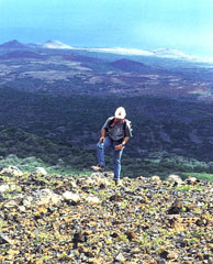 The Lomas Coloradas cones along the SW coast of Socorro appear in the background behind a geologist near the summit of Cerro Evermann. A brief phreatic eruption apparently occurred from a scoria cone west of the Lomas Coloradas on 22 May 1951, witnessed from a yacht offshore at Caleta Binner. During a 5-10 minute period, a plume sequentially incandescent, black, and then white rose a short distance above the cone, and clasts fell around the cone. The plume eventually reached a height of about 1,200 m.
The maps shown below have been scanned from the GVP map archives and include the volcano on this page. Clicking on the small images will load the full 300 dpi map. Very small-scale maps (such as world maps) are not included. The maps database originated over 30 years ago, but was only recently updated and connected to our main database. We welcome users to tell us if they see incorrect information or other problems with the maps; please use the Contact GVP link at the bottom of the page to send us email.
There are no samples for Socorro in the Smithsonian's NMNH Department of Mineral Sciences Rock and Ore collection.
| Copernicus Browser | The Copernicus Browser replaced the Sentinel Hub Playground browser in 2023, to provide access to Earth observation archives from the Copernicus Data Space Ecosystem, the main distribution platform for data from the EU Copernicus missions. |
| MIROVA | Middle InfraRed Observation of Volcanic Activity (MIROVA) is a near real time volcanic hot-spot detection system based on the analysis of MODIS (Moderate Resolution Imaging Spectroradiometer) data. In particular, MIROVA uses the Middle InfraRed Radiation (MIR), measured over target volcanoes, in order to detect, locate and measure the heat radiation sourced from volcanic activity. |
| MODVOLC Thermal Alerts | Using infrared satellite Moderate Resolution Imaging Spectroradiometer (MODIS) data, scientists at the Hawai'i Institute of Geophysics and Planetology, University of Hawai'i, developed an automated system called MODVOLC to map thermal hot-spots in near real time. For each MODIS image, the algorithm automatically scans each 1 km pixel within it to check for high-temperature hot-spots. When one is found the date, time, location, and intensity are recorded. MODIS looks at every square km of the Earth every 48 hours, once during the day and once during the night, and the presence of two MODIS sensors in space allows at least four hot-spot observations every two days. Each day updated global maps are compiled to display the locations of all hot spots detected in the previous 24 hours. There is a drop-down list with volcano names which allow users to 'zoom-in' and examine the distribution of hot-spots at a variety of spatial scales. |
|
WOVOdat
Single Volcano View Temporal Evolution of Unrest Side by Side Volcanoes |
WOVOdat is a database of volcanic unrest; instrumentally and visually recorded changes in seismicity, ground deformation, gas emission, and other parameters from their normal baselines. It is sponsored by the World Organization of Volcano Observatories (WOVO) and presently hosted at the Earth Observatory of Singapore.
GVMID Data on Volcano Monitoring Infrastructure The Global Volcano Monitoring Infrastructure Database GVMID, is aimed at documenting and improving capabilities of volcano monitoring from the ground and space. GVMID should provide a snapshot and baseline view of the techniques and instrumentation that are in place at various volcanoes, which can be use by volcano observatories as reference to setup new monitoring system or improving networks at a specific volcano. These data will allow identification of what monitoring gaps exist, which can be then targeted by remote sensing infrastructure and future instrument deployments. |
| Volcanic Hazard Maps | The IAVCEI Commission on Volcanic Hazards and Risk has a Volcanic Hazard Maps database designed to serve as a resource for hazard mappers (or other interested parties) to explore how common issues in hazard map development have been addressed at different volcanoes, in different countries, for different hazards, and for different intended audiences. In addition to the comprehensive, searchable Volcanic Hazard Maps Database, this website contains information about diversity of volcanic hazard maps, illustrated using examples from the database. This site is for educational purposes related to volcanic hazard maps. Hazard maps found on this website should not be used for emergency purposes. For the most recent, official hazard map for a particular volcano, please seek out the proper institutional authorities on the matter. |
| IRIS seismic stations/networks | Incorporated Research Institutions for Seismology (IRIS) Data Services map showing the location of seismic stations from all available networks (permanent or temporary) within a radius of 0.18° (about 20 km at mid-latitudes) from the given location of Socorro. Users can customize a variety of filters and options in the left panel. Note that if there are no stations are known the map will default to show the entire world with a "No data matched request" error notice. |
| UNAVCO GPS/GNSS stations | Geodetic Data Services map from UNAVCO showing the location of GPS/GNSS stations from all available networks (permanent or temporary) within a radius of 20 km from the given location of Socorro. Users can customize the data search based on station or network names, location, and time window. Requires Adobe Flash Player. |
| DECADE Data | The DECADE portal, still in the developmental stage, serves as an example of the proposed interoperability between The Smithsonian Institution's Global Volcanism Program, the Mapping Gas Emissions (MaGa) Database, and the EarthChem Geochemical Portal. The Deep Earth Carbon Degassing (DECADE) initiative seeks to use new and established technologies to determine accurate global fluxes of volcanic CO2 to the atmosphere, but installing CO2 monitoring networks on 20 of the world's 150 most actively degassing volcanoes. The group uses related laboratory-based studies (direct gas sampling and analysis, melt inclusions) to provide new data for direct degassing of deep earth carbon to the atmosphere. |
| Large Eruptions of Socorro | Information about large Quaternary eruptions (VEI >= 4) is cataloged in the Large Magnitude Explosive Volcanic Eruptions (LaMEVE) database of the Volcano Global Risk Identification and Analysis Project (VOGRIPA). |
| EarthChem | EarthChem develops and maintains databases, software, and services that support the preservation, discovery, access and analysis of geochemical data, and facilitate their integration with the broad array of other available earth science parameters. EarthChem is operated by a joint team of disciplinary scientists, data scientists, data managers and information technology developers who are part of the NSF-funded data facility Integrated Earth Data Applications (IEDA). IEDA is a collaborative effort of EarthChem and the Marine Geoscience Data System (MGDS). |

