OVSICORI-UNA conducted an overflight of Arenal on 14 September to measure gas emissions, and found low concentrations of carbon dioxide, water, and hydrogen sulfide. An infrared camera detected a ring of thermal anomalies along the rim of Crater C.
Source: Observatorio Vulcanologico y Sismologico de Costa Rica-Universidad Nacional (OVSICORI-UNA)
Continued calm with minor gas emissions
Since 1968, Arenal experienced periods of moderate-to-robust volcanic activity that continued through September 2010, when activity declined (BGVN 35:07 and 36:04). This report discusses events between December 2010 and October 2012, a period of continued relative tranquility.
Although sporadic Strombolian explosions were reported in December 2010, they soon ceased; since then, no explosions had occurred through as late as October 2012. According to the Observatorio Vulcanologico Sismologica de Costa Rica-Universidad Nacional (OVSICORI), activity was limited to weak gas emissions, primarily through the NE vent in Crater C and through fumaroles in Crater D (figure 113).
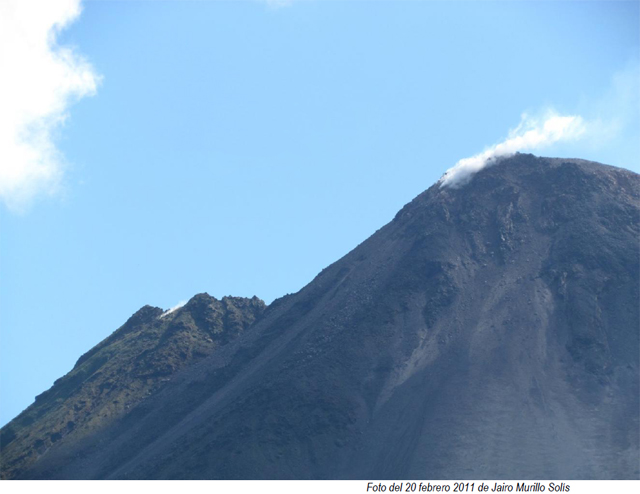 |
Figure 113. A photograph of Arenal's summit taken on 20 February 2011, featuring the volcano's two peaks, both showing weak fumaroles. To the right is crater C, which has been active since 1968; to the left is crater D. Courtesy of Jairo Murillo Solís. |
During the reporting period, the pH of rain-water gradually increased near the volcano. According to OVSICORI, the gradual decrease in rainfall acidity was associated with reduced magmatic activity.
According to OVSICORI, 2012 was one of the years of lowest activity for Arenal since 1968. No volcano-tectonic earthquakes, volcanic earthquakes, or tremors were recorded during the year, and no magmatic activity was detected. OVSICORI (citing Muller and others, 2011) reported that the Electronic Distance Measurement (EDM) network on the W flank of Arenal showed some subsidence from 2008 to near the end of 2011, but then the rate of subsidence decreased and no deformation occurred in 2012.
In June 2012, OVSICORI reported that night observations and long-exposure photographs of the summit revealed no incandescence. According to OVSICORI, the lack of incandescence indicated that gas emissions were of low temperature (probably <300°C), allowing water vapor to condense rapidly upon contact with the atmosphere. Hydrothermal activity remained low with only a few diffuse fumaroles rising from the N flank of Crater C (figure 113).
According to OVSICORI, an Mw 7.6 earthquake on 5 September 2012 centered on the Nicoya Peninsula (Costa Rica) caused moderate rock avalanches at Arenal, mainly dislodging unstable blocks on the active crater's N and NW rim. However, no changes were noted either in the hot springs around the volcano or in surficial expressions of volcanism.
A special issue of Journal of Volcanology and Geothermal Research was devoted to Arenal volcano (see Reference subsection below).
References. Marsh, B. (ed.), 2006, Arenal volcano, Costa Rica: Magma genesis and volcanological processes, Journal of Volcanology and Geothermal Research, v. 157, issues 1-3.
Muller, C., del Potro, R., Gottsmann, J., Biggs, J., and Van der Laat, R., 2011, Combined GPS, EDM and triangulation surveys of the rapid down-slope motion of the western flank of Arenal Volcano, Costa Rica, American Geophysical Union, Fall Meeting 2011, abstract ## V53C-2639 (Poster).
Information Contacts: Observatorio Vulcanologico Sismologica de Costa Rica-Universidad Nacional (OVSICORI-UNA), Apartado 86-3000, Heredia, Costa Rica (URL: http://www.ovsicori.una.ac.cr/); CostaRica21 (URL: http://www.costarica21.com/).
2013: September
2011: August
2010: January
| March
| April
| May
| June
| September
| October
| December
2009: February
| March
| April
| May
| June
| October
| November
2008: January
| February
| April
| June
| September
2007: March
| June
| August
| September
| December
2006: March
| May
| August
| September
| October
2005: November
2004: July
2003: January
| September
2001: March
OVSICORI-UNA conducted an overflight of Arenal on 14 September to measure gas emissions, and found low concentrations of carbon dioxide, water, and hydrogen sulfide. An infrared camera detected a ring of thermal anomalies along the rim of Crater C.
Source: Observatorio Vulcanologico y Sismologico de Costa Rica-Universidad Nacional (OVSICORI-UNA)
OVSICORI-UNA reported that plumes composed mainly of water vapor rose from the NE and SE edges of Arenal's Crater C on 8 and 9 September. Tremors indicative of hydrothermal and magmatic activity were detected on 8 September. The report noted that seismic and fumarolic activity had been very low in the past three years; however steam plumes associated with heavy rains had been frequent.
Source: Observatorio Vulcanologico y Sismologico de Costa Rica-Universidad Nacional (OVSICORI-UNA)
OVSICORI-UNA reported that occasionally during early mornings in July web-camera images showed a plume rising from Arenal that drifted SE and S. Scientists that conducted fieldwork during 29-30 July observed plumes rising from the last cone that formed in the NE part of Crater C.
Source: Observatorio Vulcanologico y Sismologico de Costa Rica-Universidad Nacional (OVSICORI-UNA)
OVSICORI-UNA reported that during November, activity originating from Arenal's Crater C was at a low level and consisted of gas emissions, sporadic Strombolian eruptions, and occasional avalanches. Residents to the N, W, and S observed a decrease in gas emissions and nighttime incandescence from the crater. Acid rain and small amounts of ejected pyroclastic material affected the NE, E, and SE flanks. Crater D produced only fumarolic activity.
Source: Observatorio Vulcanologico y Sismologico de Costa Rica-Universidad Nacional (OVSICORI-UNA)
OVSICORI-UNA reported that during September, activity originating from Arenal's Crater C was at a low level and consisted of gas emissions, sporadic Strombolian eruptions, and occasional avalanches. Residents to the N observed material ejected from Strombolian explosions descending the N flank. Acid rain and small amounts of ejected pyroclastic material affected the NE, E, and SE flanks. Crater D produced only fumarolic activity.
Source: Observatorio Vulcanologico y Sismologico de Costa Rica-Universidad Nacional (OVSICORI-UNA)
OVSICORI-UNA reported that during August activity originating from Arenal's Crater C consisted of gas emissions, sporadic Strombolian eruptions, and occasional avalanches. Some of the Strombolian eruptions caused glass to vibrate in buildings located 6.5 km NE. Block avalanches descended the N and NE flanks. Acid rain and small amounts of ejected pyroclastic material affected the NE, E, and SE flanks. Crater D produced only fumarolic activity.
Source: Observatorio Vulcanologico y Sismologico de Costa Rica-Universidad Nacional (OVSICORI-UNA)
OVSICORI-UNA reported that during June activity originating from Arenal's Crater C consisted of gas emissions, sporadic Strombolian eruptions, and occasional avalanches. Some of the Strombolian eruptions caused glass to vibrate in buildings located 4 km N. A lava flow that began in mid-January remained active on the S flank. Avalanches from edges of the lava flow and from the N and NE crater rim descended multiple flanks. Acid rain and small amounts of ejected pyroclastic material affected the NE, E, and SE flanks. Small explosions of gas and occasionally ash originated from a vent N of Crater C, while Crater D produced only fumarolic activity.
Source: Observatorio Vulcanologico y Sismologico de Costa Rica-Universidad Nacional (OVSICORI-UNA)
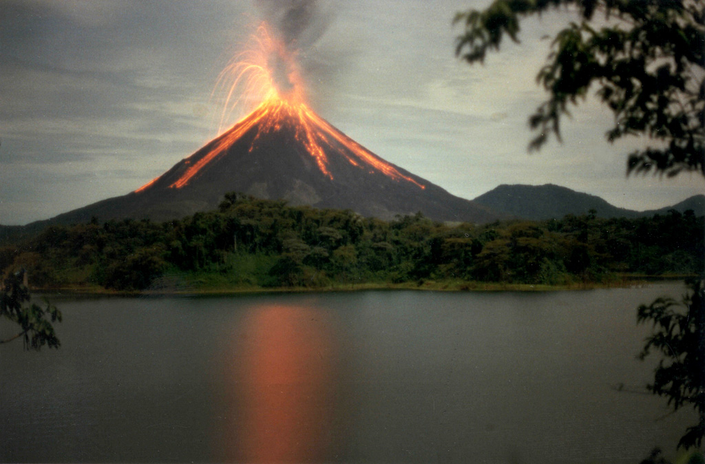
OVSICORI-UNA reported that on 24 May a series of incandescent flows descended the W flank, towards the lake, reaching the forest. An ash plume drifted N. Arenal National Park was closed briefly due to the activity.
Source: Observatorio Vulcanologico y Sismologico de Costa Rica-Universidad Nacional (OVSICORI-UNA)
According to news articles, an eruption from Arenal on 24 May produced gas and ash emissions as well as multiple lava flows, prompting the evacuation of Arenal National Park.
Source: Agence France-Presse (AFP)
OVSICORI-UNA reported that during April activity originating from Arenal's Crater C consisted of gas emissions, sporadic Strombolian eruptions, infrequent ash emissions, and occasional avalanches. A lava flow that began in mid-January remained active on the S flank. Acid rain and small amounts of ejected pyroclastic material affected the NE, E, and SE flanks. Avalanches from the crater and from lava-flow fronts traveled down the SW, S, and SE flanks, occasionally igniting vegetation. Crater D produced only fumarolic activity.
Source: Observatorio Vulcanologico y Sismologico de Costa Rica-Universidad Nacional (OVSICORI-UNA)
OVSICORI-UNA reported that during March activity originating from Arenal's Crater C consisted of gas emissions, sporadic Strombolian eruptions, and occasional avalanches. A lava flow that began in mid-January remained active on the S flank. Acid rain and small amounts of ejected pyroclastic material affected the NE, E, and SE flanks. Avalanches from the crater and from lava-flow fronts traveled down the SW, S, and SE flanks, occasionally igniting vegetation. Crater D produced only fumarolic activity.
Source: Observatorio Vulcanologico y Sismologico de Costa Rica-Universidad Nacional (OVSICORI-UNA)
OVSICORI-UNA reported that during February activity originating from Arenal's Crater C consisted of gas emissions, sporadic Strombolian eruptions, and occasional avalanches. A lava flow traveled down the SW flank. Acid rain and small amounts of ejected pyroclastic material affected the NE and SE flanks. Avalanches from the crater and from lava-flow fronts traveled down the SW, S, and SE flanks, occasionally igniting vegetation. Crater D produced only fumarolic activity.
Source: Observatorio Vulcanologico y Sismologico de Costa Rica-Universidad Nacional (OVSICORI-UNA)
OVSICORI-UNA reported that during December activity originating from Arenal's Crater C consisted of gas emissions, sporadic Strombolian eruptions, and occasional avalanches that traveled down the W and SW flanks. Acid rain and small amounts of ejected pyroclastic material affected the NE and SE flanks. Avalanches from lava-flow fronts traveled down the SW flanks. Crater D produced only fumarolic activity.
Source: Observatorio Vulcanologico y Sismologico de Costa Rica-Universidad Nacional (OVSICORI-UNA)
OVSICORI-UNA reported that during October activity originating from Arenal's Crater C consisted of gas emissions, sporadic Strombolian eruptions, and occasional avalanches that traveled down the W and SW flanks. Acid rain and small amounts of ejected pyroclastic material affected the NE and SE flanks. Avalanches from lava-flow fronts traveled down the SW flanks. Crater D produced only fumarolic activity.
Source: Observatorio Vulcanologico y Sismologico de Costa Rica-Universidad Nacional (OVSICORI-UNA)
OVSICORI-UNA reported that during September activity originating from Arenal's Crater C consisted of gas emissions, sporadic Strombolian eruptions, and occasional avalanches that traveled down the W flank. Acid rain and small amounts of ejected pyroclastic material affected the NE and SE flanks. Avalanches from lava-flow fronts traveled down the SW flanks. Crater D produced only fumarolic activity.
Source: Observatorio Vulcanologico y Sismologico de Costa Rica-Universidad Nacional (OVSICORI-UNA)
OVSICORI-UNA reported that during May activity originating from Arenal's Crater C consisted of gas emissions, sporadic Strombolian eruptions, and occasional avalanches that traveled down the SW, S, and N flanks. Acid rain and small amounts of ejected pyroclastic material affected the NE and SE flanks. Small avalanches traveled down several ravines. Crater D produced only fumarolic activity.
A small eruption on 16 June was verified by field observations on 17 June. The eruption caused avalanches that descended the S flank to an 800-m elevation a.s.l. An ash plume drifted W.
Source: Observatorio Vulcanologico y Sismologico de Costa Rica-Universidad Nacional (OVSICORI-UNA)
Three strong eruptions on 16 June resulted in pyroclastic flows. The National Park was evacuated as a precaution, but reopened the next day. Increased degassing the previous week had prompted an elevation of the hazard status to Level 3 (on a scale of 1-4).
Sources: Tico Times; Inside Costa Rica
OVSICORI-UNA reported that during April activity originating from Arenal's Crater C consisted of gas emissions, sporadic Strombolian eruptions, and occasional avalanches that traveled down the SW, S, and N flanks. Acid rain and small amounts of ejected pyroclastic material affected the NE and SE flanks. Small avalanches of volcanic material traveled down several ravines. Crater D showed only fumarolic activity.
Source: Observatorio Vulcanologico y Sismologico de Costa Rica-Universidad Nacional (OVSICORI-UNA)
OVSICORI-UNA reported that during March activity originating from Arenal's Crater C consisted of gas emissions, sporadic Strombolian eruptions, and occasional avalanches from the fronts of lava flows that traveled down the SW flanks. Acid rain and small amounts of ejected pyroclastic material affected the NE and SE flanks. Small avalanches of volcanic material traveled down several ravines. Crater D showed only fumarolic activity.
Source: Observatorio Vulcanologico y Sismologico de Costa Rica-Universidad Nacional (OVSICORI-UNA)
OVSICORI-UNA reported that during February, activity originating from Arenal's Crater C consisted of gas emissions, sporadic Strombolian eruptions, and occasional avalanches from lava-flow fronts that traveled down the SW flanks. Acid rain and small amounts of ejected pyroclastic material affected the NE and SE flanks. Small avalanches of volcanic material traveled down several ravines. Crater D showed only fumarolic activity.
Source: Observatorio Vulcanologico y Sismologico de Costa Rica-Universidad Nacional (OVSICORI-UNA)
OVSICORI-UNA reported that during January, activity originating from Arenal's Crater C consisted of gas emissions, sporadic Strombolian eruptions, and occasional avalanches from lava-flow fronts that traveled down the SW flanks. Volcanic activity was at relatively low levels and few eruptions occurred. Acid rain and small amounts of ejected pyroclastic material affected the NE and SE flanks. Eruptions produced ash plumes that rose about 2.2 km (7,100 ft) a.s.l. Small avalanches of volcanic material traveled down several ravines. Crater D showed only fumarolic activity.
Source: Observatorio Vulcanologico y Sismologico de Costa Rica-Universidad Nacional (OVSICORI-UNA)
OVSICORI-UNA reported that changes in morphology and the health of vegetation at Arenal were documented during approximately 14-20 September. Fine ashfall produced at the summit by an active lava flow impacted and burned vegetation along the upper and lower E and NE flanks. The impact on the vegetation was more severe near the summit. By mid September, additional material moving down the SW flank had filled the 6 June collapse scar and built an 800-m-high levee. Occasional incandescent blocks roll down the top of the levee. Material accumulated on both sides of the levee and at the distal end, creating a 200-m-wide fan. A mass of material also accumulated at the SW edge of the summit, causing blocks to occasionally roll down the N flank.
Source: Observatorio Vulcanologico y Sismologico de Costa Rica-Universidad Nacional (OVSICORI-UNA)
OVSICORI-UNA reported that during August, activity originating from Arenal's Crater C consisted of gas emissions, sporadic Strombolian eruptions, and occasional avalanches from lava-flow fronts that traveled down the SW flanks. Volcanic activity was at relatively low levels and few eruptions occurred. Acid rain and small amounts of ejected pyroclastic material affected the NE and SE flanks. Eruptions produced ash plumes that rose about 2.2 km (7,100 ft) a.s.l. Small avalanches of volcanic material traveled down several ravines. Crater D showed only fumarolic activity.
Source: Observatorio Vulcanologico y Sismologico de Costa Rica-Universidad Nacional (OVSICORI-UNA)
OVSICORI-UNA reported that an incandescent avalanche descended Arenal's SW flank on 6 June producing an 800-m-long scar and depositing a wide debris fan at the base of the volcano. A plume of dust, ash, and gas drifted W and NW, depositing fine ash in a small area downwind. The plume panicked tourists and park rangers 2 km away to the W. The park was immediately closed for the day and the tourists were evacuated. According to a news article, another incandescent avalanche descended the SW flank on 10 June and generated an ash plume. Authorities evacuated people in the area.
Sources: La Nacion; Observatorio Vulcanologico y Sismologico de Costa Rica-Universidad Nacional (OVSICORI-UNA)
In March, activity originating from Arenal's Crater C consisted of gas emissions, sporadic Strombolian eruptions, and occasional avalanches from lava-flow fronts that traveled down the SW flanks. Volcanic activity was at relatively low levels and few eruptions occurred. Acid rain and small amounts of ejected pyroclastic material affected the NE and SE flanks. Eruptions produced ash plumes that rose about 2.2 km (7,100 ft) a.s.l. Small avalanches of volcanic material traveled down several ravines. Crater D showed only fumarolic activity.
Source: Observatorio Vulcanologico y Sismologico de Costa Rica-Universidad Nacional (OVSICORI-UNA)
In January, activity originating from Arenal's Crater C consisted of gas emissions, sporadic Strombolian eruptions, and occasional avalanches from lava-flow fronts that traveled down the S flanks. Blocks from the lava-flow fronts periodically reached vegetation and started small fires. Volcanic activity was at relatively low levels and few eruptions occurred. Acid rain and small amounts of ejected pyroclastic material affected the NE and SE flanks. Eruptions produced ash plumes that rose about 2.2 km (7,100 ft) a.s.l. Small avalanches of volcanic material traveled down several ravines. Crater D showed only fumarolic activity.
Source: Observatorio Vulcanologico y Sismologico de Costa Rica-Universidad Nacional (OVSICORI-UNA)
In December, activity originating from Arenal's Crater C consisted of gas emissions, sporadic Strombolian eruptions, and occasional avalanches from lava-flow fronts that traveled down the SW flank. Volcanic activity was at relatively low levels and few eruptions occurred. Acid rain and small amounts of ejected pyroclastic material affected the NE and SE flanks. Eruptions produced ash plumes that rose about 2.2 km (7,100 ft) a.s.l. Small avalanches of volcanic material traveled down several ravines. Crater D showed only fumarolic activity.
Source: Observatorio Vulcanologico y Sismologico de Costa Rica-Universidad Nacional (OVSICORI-UNA)
In November, activity originating from Arenal's Crater C consisted of gas emissions, sporadic Strombolian eruptions, lava flows traveling down the S flank, and occasional avalanches from lava-flow fronts. Blocks from near the edge of the crater rolled down the SE and SW flanks. Volcanic activity was at relatively low levels and few eruptions occurred. Acid rain and small amounts of ejected pyroclastic material affected the NE and SE flanks. Eruptions produced ash plumes that rose about 2.2 km (7,100 ft) a.s.l. Small avalanches of volcanic material traveled down several ravines. Crater D showed only fumarolic activity.
Source: Observatorio Vulcanologico y Sismologico de Costa Rica-Universidad Nacional (OVSICORI-UNA)
Based on initial observations from park visitors and resort personnel, OVSICORI-UNA reported that a pyroclastic flow from Arenal traveled W on 18 September. The event was recorded by a local seismic station.
Based on field observations, a scientist from Instituto Costarricense de Electricidad (ICE) reported that multiple pyroclastic flows traveled S an approximate distance of 1 km on 18 September. Explosions occurred that occasionally produced ash. Small avalanches were noted and one larger avalanche on the S flank was incandescent. Avalanche activity continued on 19 September.
Sources: Observatorio Vulcanologico y Sismologico de Costa Rica-Universidad Nacional (OVSICORI-UNA); Instituto Costarricense de Electricidad (ICE)
In August, activity originating from Arenal's Crater C consisted of gas emissions, sporadic Strombolian eruptions, lava flows traveling down the SW and S flanks, and occasional avalanches from lava-flow fronts. Volcanic activity was at relatively low levels and few eruptions occurred. Blocks from the lava-flow fronts periodically reached vegetation and started small fires. Acid rain and small amounts of ejected pyroclastic material affected the NE and SE flanks. Eruptions produced ash plumes that rose about 2.2 km (7,100 ft) a.s.l. Pyroclastic cones on the NE and SW flanks continued to grow. Small avalanches of volcanic material traveled down several ravines. Crater D showed only fumarolic activity.
Source: Observatorio Vulcanologico y Sismologico de Costa Rica-Universidad Nacional (OVSICORI-UNA)
In July, activity originating from Arenal's Crater C consisted of gas emissions, sporadic Strombolian eruptions, lava flows traveling SW and S, and occasional avalanches from lava-flow fronts. Blocks from the lava-flow fronts periodically reached vegetation and started small fires. Volcanic activity was at relatively low levels and few eruptions occurred. Small amounts of pyroclastic material were ejected and affected the NE and SE flanks. Eruptions produced ash plumes that rose about 2.2 km (7,100 ft) a.s.l. Ash and acid rain fell on the NE and SE flanks. Small avalanches of volcanic material traveled down several ravines. Crater D showed only fumarolic activity.
Source: Observatorio Vulcanologico y Sismologico de Costa Rica-Universidad Nacional (OVSICORI-UNA)
In May, activity originating from Arenal's Crater C consisted of gas emissions, sporadic Strombolian eruptions, lava flows traveling SW, and occasional avalanches from lava-flow fronts. Blocks from the lava-flow fronts periodically reached vegetation and started small fires. Volcanic activity was at relatively low levels and few eruptions occurred. Small amounts of pyroclastic material were ejected and affected the NE and SE flanks. Eruptions produced ash plumes that rose about 2.2 km (7,100 ft) a.s.l. Ash and acid rain fell on the NE and SE flanks. Small avalanches of volcanic material traveled down several ravines. Crater D showed only fumarolic activity.
Source: Observatorio Vulcanologico y Sismologico de Costa Rica-Universidad Nacional (OVSICORI-UNA)
In February, activity originating from Arenal's Crater C consisted of gas emissions, sporadic Strombolian eruptions, lava flows traveling N, and occasional avalanches from lava-flow fronts. Blocks from the lava-flow fronts traveled N, NE, and NW, periodically reaching vegetation where they started small fires. Volcanic activity was at relatively low levels, however, with few eruptions occurring and a small amount of pyroclastic material ejected. Eruptions produced ash plumes that rose about 2.2 km (7,100 ft) a.s.l. Ash and acid rain fell on the NE and SE flanks. Small avalanches of volcanic material traveled down several ravines. Crater D showed only fumarolic activity.
Source: Observatorio Vulcanologico y Sismologico de Costa Rica-Universidad Nacional (OVSICORI-UNA)
In September, activity originating from Arenal's Crater C consisted of gas emissions, sporadic Strombolian eruptions, lava flows traveling N, and occasional avalanches from lava-flow fronts. Blocks from the lava-flow fronts traveled N, NE, and NW, periodically reaching vegetation where they produced small fires. Volcanic activity was at relatively low levels, however, with few eruptions occurring and a small amount of pyroclastic material ejected. Eruptions produced ash plumes that rose about 2.2 km (7,100 ft) a.s.l. Ash and acid rain fell on the NE and SE flanks. Small avalanches of volcanic material traveled down several ravines. Crater D showed only fumarolic activity.
Source: Observatorio Vulcanologico y Sismologico de Costa Rica-Universidad Nacional (OVSICORI-UNA)
In August, activity originating from Arenal's Crater C consisted of gas emissions, sporadic Strombolian eruptions, lava flows traveling N, and occasional avalanches from lava-flow fronts. Volcanic activity was at relatively low levels, however, with few eruptions occurring and a small amount of pyroclastic material ejected. Eruptions produced ash plumes that rose ~500 m above the crater (~7,100 ft a.s.l.). Ash and acid rain fell on the NE and SE flanks. Small avalanches of volcanic material traveled down several ravines. Crater D showed only fumarolic activity.
Source: Observatorio Vulcanologico y Sismologico de Costa Rica-Universidad Nacional (OVSICORI-UNA)
In July, activity from Arenal's Crater C consisted of lava flows traveling N, gas emission, sporadic Strombolian eruptions, and occasional avalanches from lava-flow fronts. Volcanic activity was at low levels, with few eruptions occurring and a small amount of pyroclastic material ejected. Eruptions produced ash plumes that rose ~500 m above the crater (or 7,100 ft a.s.l.). Ash and acid rain fell on the NE and SE flanks. Small avalanches of volcanic material traveled down several ravines. There was only fumarolic activity at Crater D.
Source: Observatorio Vulcanologico y Sismologico de Costa Rica-Universidad Nacional (OVSICORI-UNA)
On 10 May around 1000, a pyroclastic flow traveled down Arenal's N flank. An ash-and-gas cloud was produced that drifted SW.
Source: Observatorio Vulcanologico y Sismologico de Costa Rica-Universidad Nacional (OVSICORI-UNA)
OVSICORI reported that on 2 April around 1000 a small pyroclastic flow traveled down Arenal's W flank.
Source: Observatorio Vulcanologico y Sismologico de Costa Rica-Universidad Nacional (OVSICORI-UNA)
In February, activity at Arenal's Crater C consisted of lava flows traveling SW and W, gas emission, sporadic Strombolian eruptions, and occasional avalanches from lava-flow fronts. Volcanic activity was at low levels, with few eruptions occurring and a small amount of pyroclastic material ejected. Eruptions produced ash plumes that rose ~500 m above the crater (or 7,100 ft a.s.l.). Ash and acid rain fell on the NE, E, and SE flanks. Small avalanches of volcanic material traveled down several ravines. There was only fumarolic activity at Crater D.
Source: Observatorio Vulcanologico y Sismologico de Costa Rica-Universidad Nacional (OVSICORI-UNA)
Explosive activity began at Arenal on 2 November at 1454. A pyroclastic flow was generated at 1502 and movement continued for ~10 minutes. During a visit to the volcano the next day, OVISICORI-UNA scientists found that the mid-sized pyroclastic flow traveled down the volcano's W flank, producing an ash cloud that drifted SE. An area was impacted that extended from the volcano's summit to about 1,000 m a.s.l. on Arenal's W flank. The pyroclastic flow occurred in an area that is closed to visitors. During the previous several months lava flows on the volcano's SW flank had been growing rapidly.
Source: Observatorio Vulcanologico y Sismologico de Costa Rica-Universidad Nacional (OVSICORI-UNA)
Since an eruption during the evening of 6 July sent an avalanche of lava cascading down the side of Arenal volcano, no subsequent activity has been reported. According to news reports, on 7 July, Costa Rica's National Emergency Commission (CNE) issued an alert and prohibited people from approaching the volcano.
Source: Agence France-Presse (AFP)
A sequence of pyroclastic flows began at Arenal on 5 September at 1055. Seismographs recorded eight signals within 2 hours after the activity began. Lava flows descended to 800 m down the volcano's N and NE flanks. Ash drifted towards the W and NW. No injuries or deaths were reported and the main effects were limited to the National Park boundaries.
Sources: Reuters; Observatorio Vulcanologico y Sismologico de Costa Rica-Universidad Nacional (OVSICORI-UNA); Associated Press
During December activity at Arenal consisted of continuous gas emissions, lava flows towards the W flank, and sporadic Strombolian eruptions. In addition, fumarolic activity occurred at Crater D.
Source: Observatorio Vulcanologico y Sismologico de Costa Rica-Universidad Nacional (OVSICORI-UNA)
On 29 March OVSICORI-UNA personnel visited the area affected by pyroclastic flows that traveled down the flanks of Arenal on 24, 25, and 26 March. The pyroclastic-flow deposits were located on the N and NE flanks of the volcano. The ash clouds produced from the pyroclastic flows drifted towards the W and SW, depositing ash on an area up to 10 km2 including two towns. Some of the block-and-ash deposits were several meters thick and the debris fan was up to 250 m wide. There were no reports of injuries or damage to buildings.
Source: Observatorio Vulcanologico y Sismologico de Costa Rica-Universidad Nacional (OVSICORI-UNA)
OVSICORI-UNA reported on 26 March that at least three pyroclastic-flow episodes occurred on 24 March between 1234 and 1342. Unlike previous pyroclastic flows, these descended the W flank. National Park guards observed the resulting ash clouds moving SW. There were no reports of injuries or damage.
Source: Observatorio Vulcanologico y Sismologico de Costa Rica-Universidad Nacional (OVSICORI-UNA)
Reports are organized chronologically and indexed below by Month/Year (Publication Volume:Number), and include a one-line summary. Click on the index link or scroll down to read the reports.
Eruption kills 65; explosions cause significant ashfall followed by lava flows
Notification Report (30 July 1968) Eruption began on the night of 29 July 1968
Volcanic eruption began last night [29 July] with explosions and dense smoke cloud. Lava and burning stones being ejected. Huge quantity lava and rock spewing from volcano. Eight inches volcanic ash covered entire region. Volcano continues spurting burnign stones and lava. Ashes, rock and lava dammed rivers and brooks causing flooding. 12 people killed. Hundreds injured. 4,000 evacuated. Heavy rains hamper rescue operations. First eruption of Arenal in 500 years.
Information Report 1 (30 July 1968) Twelve deaths, evacuations, and thick ashfall
Volcano silent for 5 centuries killed 12 person injured hundreds. 4,000 evacuated from towns of Pueblo Nuevo and Tabacon when Mt. Arenal erupted Monday. A State of Emergency was declared. Heavy rains hampered rescue operations. A huge quantity of lava and rock was spewed from the volcano. 8 inches of volcanic ash covered the central part of this rich ranching region 45 miles west of San Jose. The mountain is 5,249 ft. high and it continued spurting burning stones and lava through the night. Ashes, rock and lava dammed the rivers and brooks which overflowed, adding to the damage. Mt. Arenal has been quiet for 500 years.
Information Report 2 (29 July 1968) Ash plume extended 60 km
The following telephone report was received from the Geographic Institute, San Jose, Costa Rica, at 1630 GMT on 29 July 1968: "The volcanic eruption began last night (29 July 68) with explosions followed by a dense smoke cloud. The smoke cloud was carried as far as 60 kms from the volcano. We are sending someone ot the area and will have a more descriptive report for you soon."
Information Report 3 (30 July 1968) Description of three explosions on the first day of the eruption
The following report was received by the Center by radio from San Jose, Costa Rica at 1630 EST on 30 July 1968: "The first eruption occurred at 8 a.m. local time on Monday, July 29, 1968. The volcano blew up in violent activity sending lava and ashes into the air. Ashes covered the major portion of the Province of Guanacaste. The volcano exploded at 8:00 a.m. and 4,000 people were evacuated. The ashes covred an area 50 miles to the west of the volcano. It is throwing out great quantities of ash and rocks. The town of Tilaran, 10 kms from the volcano was evacuated. The second eruption was much stronger and occurred at 11:30 a.m. and threw out great quantities of hot lava. There was also a rain of small stones. Some rocks fell that were 1 meter high. Fire and ash were thrown up and there were strong tremors on the ground. A third eruption came at 7:40 p.m. (local time). It was felt in Liberia, Philadelphia, La Fortuna, and San Carlos."
Information Report 4 (30 July 1968)
Report missing.
Information Report 5 (31 July 1968)
Report missing.
Information Report 6 (31 July 1968) Sixty-five bodies recovered; lava flows seen
The following cable was received from Costa Rica on 31 July 1968: "Ricardo Fernandez Peralta, of National Geographic Institute has provided following eyewitness report on eruptoin Arenal volcano. Sun. night nineteen tremors felt Pueblo Nuevo on western slope of volcano. Mon. morning began under cloudy skies, short, heavy rains alternating with good weather. 0730 loud noise heard followed by stones falling in area. Heavy cinder shower followed. 0800 clouds dense black smoke seen, sand continued to fall. End eyewitness report.
"Six inches volcanic sand, some volcanic bombs found during ground inspection Pueblo Nuevo. Sixty-five bodies found which seems indicate noxious, burning gas. All vegetation destroyed western slope volcano. Fish found dead in streams in area. Photographic evidence indicates there two very narrow lava flows on slope. Aircraft reported smoke clouds 9000 feet high, current activity includes eruptions approximately every hour. However this activity appears to be decreasing."
Information Report 7 (31 July 1968) Pilot observations of ash plume
The following pilot report was received by radio from Roberto Alsaro who flew around the volcano on 30 July 1968: "I was flying at 8,000 feet near the volcano and saw a very high and very dark layer of ashes. It was at a distance of about 40 miles and was being pulled by the winds aloft. I estimate that this layered ash cloud was at 20,000 ft. The ash cloud was heading east with the upper wind levels carrying it over as far as the Atlantic coast. There was another layer of ashes over Punto Arenas at an altitude of 12,000 feet. The ash fall covered Punta Arenas. The whole area was covered with ashes. There was also a heavy ash fall on the island of San Lucas."
Information Contacts:
Notification Report (30 July 1968) United Press International (UPI); Associated Press (AP).
Information Report 1 (30 July 1968) Associated Press (AP)
Information Report 2 (29 July 1968) Ricardo Peralta and Ricardo Sernandez, Instituto Geografico, San Jose, Costa Rica.
Information Report 3 (30 July 1968) Les Anderson, Amateur Radio Operator TI2LSA, San Jose, Costa Rica.
Information Report 4 (30 July 1968) Report missing.
Information Report 5 (31 July 1968) Report missing.
Information Report 6 (31 July 1968) Ricardo F. Peralta, National Geographic Institute, San Jose, Costa Rica.
Information Report 7 (31 July 1968) Roberto Alsara (via Les Anderson), San Jose, Costa Rica.
Continued strong explosions into mid-August; more deaths from a pyroclastic flow
Information Report 8 (01 August 1968) Continued large explosions; 8 more people killed
The following report was received by radio from the Costa Rica Geographical Institute at 1530 GMT on 1 August 1968: "Tremendous explosion at 6:30 a.m. yesterday. It was the largest explosion up to that time. A still larger explosion, the largest one to date, occurred at 1:50 p.m. yesterday. The explosion killed 8 people riding in Jeeps on an inspection tour 3 kilometers from the volcano. There is a lot of heat in the area and numerous rock falls."
Information Report 9 (01 August 1968) Air waves detected from explosions
The following information on the detection of two air waves resulting from explosive eruptions of Mt. Arenal was reported to the Center from Boulder, Colorado on August 1, 1968: "The first signal was received at 23h 50m GMT on 30 July 1968 with an amplitude of 2 dynes per square centimeter peak to peak and a period on the order of 20 to 40 seconds. The second signal was received at 22h 29m 30s GMT on 31 July 1968 with an amplitude of 3.8 dynes per square centimeter peak to peak and a period on the order of 25-45 seconds. Both signals were real clean for the first 10 minutes and lasted for about an hour."
Information Report 10 (03 August 1968) Variable explosions on 2 August
The following report was received by radio from Costa Rica at 1600 GMT on 3 August 1968: "On 2 August there was one eruption with nine consecutive explosions of variable intensity which lasted one hour and 24 minutes. The explosions began at 2125 GMT and ended at 2249 GMT. They were accompanied by some black and some white gas and vapor. By 11:00 p.m. last night (0500 GMT on 3 August) no ash had fallen for 60 hours."
Information Report 11 (03 August 1968) Observations on 1-2 August
The following report was received by radio from Dr. Thomas Simkin, Smithsonian Institution, who arrived in Costa Rica on August 1st and made a preliminary reconnaissance visit to the volcano on August 2nd.
"On 2 August a single eruption was reported to have occurred between 2125 GMT and 2249 GMT. On 2 August we observed a vent steaming between 2310 GMT and 2320 GMT. We saw no evidence of Nuee Ardentes, although we have heard reports of phenomena that sound like Nuee Ardentes. We were told that the flow that killed eight people on an inspection tour on Wednesday was made up of lava, gas, rock, and mud. This event was associated with an explosive eruption and seismic activity.
"We visited the town of Fortuna, five kilometers to the east of the volcano, and interviewed a number of people. Here is their report: On 1 August at 1015 GMT four loud explosions were heard. These were accompanied by strong East-West tremors. At 1200 GMT there were two additional loud explosions. At 1530 GMT an earthquake was reported by a rescue party. At 2000 GMT the cloud cover cleared for 15 minutes and the local people saw no change in the volcano's morphology. At 2015 GMT a steam cloud was emitted from the summit and moved towards Fortuna. At 0320 GMT on 2 August people started seeing flashes through the cloud cover at five-second intervals. There was an intense light from the summit, like flashbulbs from within the crater."
Information Report 12 (02 August 1968) News report of initial eruptions
The following report of the initial activities of the eruption was received from La Nacion newspaper on 2 August 1968. The report indicates the occurrence of nuee ardente phenomena but these have not been confirmed. (translated from the Spanish)
"At 8:40 last Monday the Arenal volcano produced an eruption similar to that of Mount Pele which broke the cone of the volcano at half the altitude in the northeast sector. Through the gap opened by the tremendous interior pressure from the volcano, first a cloud of sulfuric acid gas escaped, then sulfuric acid, cloric acid and other gasses which, at a velocity of 100 kilometers per hour, covered an area 2 kilometers wide and at least 12 kilometers long. The temperature of these gasses was 800° centigrade.
"Almost simultaneously with the blanket of incandescent gasses, the first eruption was produced with ashes and ignited stones that covered the whole area. Upon breaking a seal which imprisoned gasses, the volcano lost intensity and continued filling the air with hot ashes and incandescent stones that, carried by the wind, have covered most of the center of the Province of Guanacaste, and have been carried as far as Granada, Nicaragua. Confirming the findings of the geologists, the most dangerous aspect of the phenomena, lethal incandescent gasses, has already passed."
Information Report 13 (06 August 1968) Additional explosions during 2-4 August
The following report was received by radio from Dr. Tom Simkin at San Jose at 0230 GMT on 6 August: "There were small eruptions at 2158 GMT and 2216 GMT on 2 August, 10 small eruptions producing white eruption clouds between 2217 and 2253 GMT, and a stronger eruption accompanied by black smoke and ashes at 0200 GMT on 3 August. At 1459 and again at 1600 GMT there were eruptions that produced white clouds. At 1700 GMT on 4 August there was a strong eruption that produced a large ash fall in Nicoya. At 2112 GMT there were two strong rumblings reported at Fortuna. Another strong ash eruption occurred at 2326 and lasted until 2350 GMT. On 5 August there was continuous eruption activity between 1730 and 2030 GMT and an additional large eruption at 2200 GMT"
Information Report 14 (06 August 1968) Investigation of the deadly nuee ardente that killed 10
The following report from Dr. William Melson, Smithsonian Institution and Dr. Rodriquez Saenz, Direccion de Geologia Minas y Petrologio, San Jose, was received by radio from Costa Rica at 0240 GMT on 6 August:
"We examined in detail the site at which 10 men were killed last Wednesday, July 31, 1968. This examination shows conclusively that low-angle directed blasts of hot gases, ash, and blocks occurred. These eruptions appear to be appropriately termed nuee ardentes of the Pelean type. It appears that there have been two unusually intense Pelean type blasts; the one of Monday (July 29th) and the one of Wednesday (July 31st). Activity is now confined to weak pulsating emissions of viscous blocky material from the crater accompanied by explosions. Weak explosions occurred most recently at 0145 GMT on 3 August and at 2000 GMT on 5 August. Activity during this period produced small steam and ash clouds which were carried up a short distance and 5-10 kms to the west by prevailing winds.
"The 10 men killed in the Jeeps on Wednesday were caught in the inner margin of a nuee ardente. Two impact craters occur in the road near the Jeeps. The main damage to the Jeeps was caused by the intense heat of the blast. A gas tank of one Jeep was ignited. We have confirmed that ejecta craters measuring up to two meters in diameter occur as far away as ten kilometers from the volcano. The extensive cratering associated with the nuee ardentes is of special interest.
"Rocks so far recovered from the current eruption are not pumiceous; they are relatively dense, glassy, porphyritic rocks which may be identified as hypersthene andesites or possibly dacites. It is impossible to accurately predict the course of the eruption, as it has now been six days since the last major explosion. We believe there is a 50% chance that there will be additional nuee ardentes."
Information Report 15 (07 August 1968)
Report missing.
Information Report 16 (07 August 1968) Explosions continuing during 6-7 August
The following report was received from Mr. Richard Berg, American Embassy, San Jose, Costa Rica, on 7 August 1968: "6 August loud rumbling noises followed by eruptions rising as high as 40,000 feet at 1025 GMT. Volcano was calm by 1200 GMT. Smaller eruptions started again at 1840 GMT with eruptions still continuing at 2300 GMT. 7 August constant eruptions since 1300 GMT."
Information Report 17 (07 August 1968)
Report missing.
Information Report 18 (09 August 1968)
The following report was received from the American Embassy, San Jose, Costa Rica at 0430 GMT 9 August 1968:
"Seismograph began recording 0447 GMT August 7 approx 5 km from Arenal at La Fortuna. Seven local events, all smaller than magnitude 3 recorded during 16 hour period. Continuous pulsating ash emission throughout August 6. Ash clouds rising maximum 1000 ft above crater with considerable ash fall on region, west to northwest of crater. La Fortuna region remains unaffected. Above type activity continuous since morning August 3. Ciudad Quesada at 1750 GMT August 7 reported eruptions since 1300 GMT Aug 7. Tilaran reported eruptions containing ashes at 2125 Aug 7. Farmers reported rumbling sounds heard from Mount El Cacao located in Canas Dulces region NE Liberia in same range de la Vieja volcano."
Information Report 19
Report omitted.
Information Report 20 (12 August 1968)
Report missing.
Information Report 21 (12 August 1968) Decreasing seismicity during 8-10 August; new crater discovery
The following report was received from the American Embassy, San Jose, Costa Rica, 12 August 1968:
Melson reports on activity 1800 Aug. 8 to 1700 Aug. 9 as follows: "Ash emission continues to decrease. Activity consists mainly of pulsating emission of steam. Matumoto reports seismic activity has shown marked increase during the past 24 hours. Following approximately two hours harmonic tremor, swarm of earthquakes recorded during early morning August 9. 64 events of less than magnitude 3 occurred between 0600 and 2030 GMT. Majority these events seem to be of shallow origin."
Melson reports activity on August 10: "Seismic activity has again decreased in past 24 hours. Total of 9 events recorded according to Matumoto. Earthquake of 3.5 magnitude occurred August 10, 0855 GMT. This was largest since Matumoto began recording August 6. 8 microearthquakes preceded this event. Rodrigo Saenz and I ascended to about 1100 meters on west side Arenal to confirm our suspicions there was a crater at that altitude. We discovered a crater, now with only intense fumarolic emission, at about one kilometer west of pre-eruption crater. We believe this crater was formed during initial explosions of July 29. Crater is about 200 meters in diameter, and around 30 meters deep. The caustic vapors (rich in HCl and sulphur dioxide) made precise observations on crater's features difficult. Activity at upper crater, which we estimate to be about 200 meters below old summit crater and located west of old crater, continues to decrease. Activity now mainly quiet steam emission with only traces of ash."
Information Report 22 (13 August 1968) Large explosions on 13 August
The following report was received from Dr. Thomas Simkin at San Jose, Costa Rica, on 13 August 1968: "Report of 13 August 1968. Arenal began erupting violently this morning at 1100 GMT with big explosions at 1235 and 1300 GMT. Pilot reports 25,000 foot eruption cloud at 1215 GMT. Commercial pilot reports eruption cloud decreased to 12,000 feet by 1400 GMT. Landslide reported at Cerro Jabonal volcano 35 kms south of Mt. Arenal and 70 kms WNW of San Jose."
Information Report 23 (16 August 1968)
Report missing.
Information Contacts:
Information Report 8 (01 August 1968) Ricardo Sernendez (via Les Anderson), Geographic Institute, San Jose, Costa Rica.
Information Report 9 (01 August 1968) V.H. Goerke, ESSA Infrasonic Station, Boulder CO, USA.
Information Report 10 (03 August 1968) Les Anderson, Costa Rica.
Information Report 11 (03 August 1968) Thomas Simkin, Smithsonian Institution.
Information Report 12 (02 August 1968) La Nacion news, San Jose, Costa Rica.
Information Report 13 (06 August 1968) Tom Simkin, Smithsonian Institution.
Information Report 14 (06 August 1968) William Melson, Smithsonian Institution; Rodriguez Saenz, Direccion de Geologia Minas y Petrologio, San Jose, Costa Rica.
Information Report 15 (07 August 1968) Report missing.
Information Report 16 (07 August 1968) Richard Berg, American Embassy, San Jose, Costa Rica.
Information Report 17 (07 August 1968) Report missing.
Information Report 18 (09 August 1968) Tom Simkin, Smithsonian Institution (via American Embassy, San Jose, Costa Rica).
Information Report 19 Report omitted.
Information Report 20 (12 August 1968) Report missing.
Information Report 21 (12 August 1968) William Melson, Smithsonian Institution (via American Embassy, San Jose, Costa Rica).
Information Report 22 (13 August 1968) Tom Simkin, Smithsonian Institution (via American Embassy, San Jose, Costa Rica).
Information Report 23 (16 August 1968) Report missing.
Laser ranging on a possible atmospheric dust cloud caused by the eruption
Card 0044 (10 September 1968) Laser ranging on a possible atmospheric dust cloud caused by the eruption
The following report on laser ranging on a possible dust cloud in the atmosphere was received on 10 September 1968 from the Smithsonian Astrophysical Observing Station, Mt. Hopkins, Arizona. "John Masterson of the National Center for Atmospheric Research, Boulder, Colorado, believes that a dust cloud may have formed at the 15-20 km region in the atmosphere as a result of the recent Mt. Arenal volcanic activity [in] Costa Rica. A routine patrol was initiated at Mt. Hopkins and on the nights with excellent seeing conditions the laser was pulsed at the zenith. The results of the returns shown on the oscilloscope were recorded on Polaroid photographs. By use of a 10-microsecond sweep rate and the variable trigger delay, a profile of the atmosphere was constructed up to approximately 54 km above MSL. Preliminary results from four nights with good seeing conditions show an enhancement of 2-3 times molecular scattering in the 16-17 km region."
Information Contacts: John Scott, Smithsonian Astrophysical Observing Station.
Explosions in mid-September followed by lava flows
Card 0094 (01 October 1968) Explosive eruptions in mid-September followed by lava flows from the crater
Renewed Mt. Arenal activity report, dated 20 September 1968, was received on 1 October 1968. "New eruption of the explosive type occurred starting on 14 September and lasting until 18 September (table 1). No nuees ardentes were formed on 18 September. Very little ash was erupted. On the 18th at about 1058 there was an explosive eruption and during the night the crater showed glowing inside probably from near-surface lava. On 19 September there seemed to be a mass of lava showing over the lower crater lip. On 20 September lava began running down from the crater very slowly."
Table 1. Summary of explosions at Arenal, 14-18 September 1968.
| Date | Time of explosions |
| 14 Sep 1968 | 1405 |
| 15 Sep 1968 | 1445-1615 |
| 16 Sep 1968 | 1300 |
| 18 Sep 1968 | 1058 (ash and vapor continued all day) |
Card 0095 (01 October 1968) Fieldwork confirms flank vent and lava flows
The following report, dated 25 September 1968, was received on 1 October 1968. "Today in the morning, we climbed the slopes of Arenal volcano and were able to confirm the report by operator Cordoba that there is a hole in the side of the volcano through which lava flows moving toward the north and northwest of the lower crater. The approximate speed of the lava is 1.5-2.0 m/day. The thickness is 10-20 m. The distance of the flow front is now (25 September) 200 m from fumarolic activity and ash activity is very limited. This opening through which lava flows does not present a danger at the present time."
Card 0110 (08 October 1968) Lava flow that began on 19 September was 800 m long by the 30th
"A lava flow started 19 September at Volcán Arenal and is still moving very slowly at a rate of 1.5-3 m/day. The lava is of the aa type. On 30 September I flew over Arenal and the lava flow was approximately 800 m long on that date."
Card 0118 (11 October 1968) Lava flowing at a rate of 10 m per day
The following report was received from the American Embassy in Costa Rica, 10 October 1968. "Lava flowing NNW, rate 10 m/day, 100 m wide, 25 m deep, extending as of 6 October approximately 1 km from crater outlet. No ash emission, little vapor."
Card 0128 (14 October 1968) Lava flow rate increased to 1.15 m per hour
The following report was received via the American Embassy, San José, Costa Rica, from Rodrigo Saenz R., 14 October 1968. "As of 10 October lava flow increased to 1.15 m/hour, same direction."
Information Contacts:
Card 0094 (01 October 1968) Rodrigo Saenz R., Seccion Sismologica y Vulcanologia de Industria y Comercio, San José, Costa Rica.
Card 0095 (01 October 1968) Rodrigo Saenz R., Seccion Sismologica y Vulcanologia de Industria y Comercio, San José, Costa Rica.
Card 0110 (08 October 1968) Rodrigo Saenz R., Seccion Sismologica y Vulcanologia de Industria y Comercio, San José, Costa Rica.
Card 0118 (11 October 1968) Rodrigo Saenz R., Seccion Sismologica y Vulcanologia de Industria y Comercio, San José, Costa Rica.
Card 0128 (14 October 1968) Rodrigo Saenz R., Seccion Sismologica y Vulcanologia de Industria y Comercio, San José, Costa Rica.
Lava flow advancing at a rate of 70 m per day
Card 0233 (14 November 1968) Lava flow advancing at a rate of 70 m per day
This report was received by direct radio contact with Robert Citron (SI) in Costa Rica on 14 November 1968. "Volcano was observed on 12 and 13 November. The length of the lava flow is now 2,000 m. During the 57 days since the aa-flow began it has averaged a rate of advance of 33 m/day. The height of the front of the aa-flow is between 20 and 25 m. The width of the aa-flow on 13 November was estimated to be 300 m. It is now estimated that the aa-flow is advancing at a rate of approximately 70 m/day."
Information Contacts: Rodrigo Saenz R., Instituto Geografico, San José, Costa Rica.
Lava front approaches road and the Tabacón River
Card 0306 (18 December 1968) Lava front approaches road and the Tabacón River
"Lava front approximately 150 m from road to Tabacón, in front of Pozo Azul Lagoon, one half km from river bed of hot and cold streams forming Tabacón river. Height 15 m. Width 200 m. Extends slightly more than 2 km from crater. On 13 December lava flowing at rate of only 1-1.5 m/day. Rate of flow recently has averaged approximately 2 m/day. If rate maintains same average, Saenz estimates it will be middle of January before it reaches hot and cold Tabacón river."
Information Contacts: Rodrigo Saenz R., Instituto Geografico, San José, Costa Rica.
More eruptions through mid-May
Card 0530 (06 May 1969) Vapor eruptions during 3-4 May
"Arenal Observatory reported vapor eruption from lower crater at 0600 on 3 May rising to height of 5,000 feet [1,500 m] over crater and at 0620 second steam eruption rising 2,000 feet [600 m] over crater. Another vapor eruption observed at 1600 on 4 May from Arenal lower crater rising an estimated 1,500 feet [450 m] above crater."
Card 0541 (13 May 1969) Multiple eruptions on 13 May
Arenal Observatory reports following eruptions 13 May from lower crater (time and height): 0900 (1,000 feet), 1100 (1,000 feet), 1200 (1,000/1,500 feet), 1300 (1,000/1,500 feet), 1400 (1,200 feet), 1600 (200/300 feet).
Card 0548 (19 May 1969) Continued eruptions on 15 May
[This card also reported Póas activity.] Earth shakes felt in San José area at 1900 and 2030 on 13 May, another at 0100 on 14 May. Eruptions on 15 May reported [from Arenal] as follows: [0610 (2,000 ft. above lake level), 0700 (1,500 ft. above lake level)]. Earthquake reported between 1800 and 1830 on 14 May also felt in Puerto Limón.
Card 0553 (21 May 1969) Considerable lava-flow activity on 16 May
The following report from Rodrigo Saenz R. was received by cable on 21 May 1969. "I flew over Arenal on May 16. There was no fumarolic activity from lower crater and only slight emissions from upper craters. There was considerable lava activity, avalanches, etc., on upper western flank of main lava flow. Essentially this is a change of direction in main flow and appears to have increased significantly since my last visit on April 20. Previous lava flow appears stationary with no significant change since April 20."
Information Contacts:
Card 0530 (06 May 1969) Richard Berg, American Embassy, San José, Costa Rica.
Card 0541 (13 May 1969) Richard Berg, American Embassy, San José, Costa Rica.
Card 0548 (19 May 1969) Richard Berg, American Embassy, San José, Costa Rica.
Card 0553 (21 May 1969) Richard Berg, American Embassy, San José, Costa Rica.
Lava flows, night glow, and crater emissions in early June
Card 0568 (04 June 1969) Typical activity generates fumarolic plume
The following is from a cable received on 3 June. Newspapers are carrying a story and photo of "new eruptions" at Arenal. Photo shows what looks like a very large white cloud emanating from the lower crater. Rodrigo Saenz, who visited Arenal on or about 22 May and based on daily observatory reports does not believe there is any increased activity, ascribes reports to lack of wind to disperse usual fumarolic emissions promptly.
Card 0604 (20 June 1969) Lava flows still active; night glow; crater emissions
"Embassy confirms on 6/7 June reports recent eruptions smoke and steam from Arenal's old top crater. Two relatively large such eruptions from this crater seen by many observers in surrounding towns on 31 May and 4 June. Embassy officer observed also on 6/7 June three new fumaroles 200-300 yards [183-274 m] S of lowest crater. Lava flow quite active on latter dates. At night lava flow and all fumaroles give off spectacular red glow."
Information Contacts:
Card 0568 (04 June 1969) Richard Berg, American Embassy, San José, Costa Rica.
Card 0604 (20 June 1969) Richard Berg, American Embassy, San José, Costa Rica.
Lava flows advance 3 km from lower crater
Card 0749 (12 September 1969) Lava flow continues to advance and has severed a road
"The Mt. Arenal flow has advanced at least another quarter of a mile during recent weeks. The lava stops periodically and appears to advance in surges or pulses toward the west and southwest. The flow recently severed the La Fortuna-Pueblo Nuevo road and continues to advance at an increased rate."
Card 0764 (24 September 1969) Lava flow keeps advancing, now 2.5-3 km from lower crater
The following cable was received on 23 September. "Fresh lava flow at Arenal continues on broad front moving primarily west and southwest of first flow [at] rate of approximately 5 feet [1.5 m] per day. Head of fresh flow 60-100 feet [18-30 m] high, 2.5-3 km from lower crater."
Information Contacts:
Card 0749 (12 September 1969) Richard Berg, American Embassy, San José, Costa Rica.
Card 0764 (24 September 1969) Richard Berg, American Embassy, San José, Costa Rica.
Description of lava flow on 6 January
Card 0852 (19 January 1970) Description of lava flow on 6 January
The following was forwarded by Dr. Parsons. "I visited Arenal on 6 January 1970 and climbed to the side crater that has been the source of all lava flows. A massive aa type flow continues to issue from this vent area amid hissing fume clouds. The latter made observation of the actual vent area impossible, due to the acrid nature of the SO2 laden fumes. Just down slope from the actual vent area on the steep side of the cone, the flow was about [90 m] in width and was moving at approximately one foot per minute. The jagged surface of the flow was quite black but red hot lava was visible in many dozens of cracks which opened and closed as the flow changed its angle of descent. The visibly moving part of the flow widened towards the foot of the volcano and merged into a great continuous 1.6-km-long, 400-m-wide strip of aa surface with curving, transverse flow ridges on its lower half. This flow must have been issuing continuously for several months, and is superimposed over the earlier flows."
Information Contacts: W.H. Parsons, Wayne State University.
New crater forms; lake ejected
Card 2200 (20 June 1975) New crater forms; lake ejected
Mt. Arenal... erupted on 17 June, killing two people and injuring many. The first activity occurred during the morning, when the volcano blew up the lake located in its cone, and opened another crater. The eruption took place somewhat later (at 0900), and reportedly caused severe damage. Several towns, including Tabacón, La Fortuna, Pueblo Nuevo, and La Palma, were affected by the eruption. The volcano erupted rock, sand, ashes, and lava. Ash fell on Tilarian and San José, where a thin coat of fine dust covered the area.
Information Contacts: William Melson, SI; San José Radio Monumental, San José, Costa Rica.
Thick block flows advancing NW from the summit crater
Arenal Volcano was very active during observations 12-22 October. Thick block flows were being emitted from the summit crater (D in figure 1) which has been greatly enlarged and now opens to the W. The flows were advancing NW. Avalanches from the flow fronts near the crater were audible about once per minute. Since the initial explosions of July-August 1968, a very large lava "delta" of basaltic andesite (about 0.1 km6 in volume) has been built, covering most of the W slope of the volcano. An additional hot avalanche was emitted in June 1975.
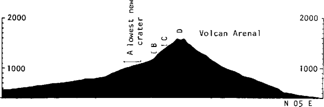 |
Figure 1. Cross-section along N85°E through Arenal, showing locations of craters (no vertical exaggeration). After Melson and Sáenz (1973). |
The activity has sequentially migrated from the lower new explosion crater (A in figure 1) to the middle slope craters (B and C), and is presently from the summit crater (D). Arenal's activity presents an excellent opportunity to observe the eruption and dynamics of thick block flows.
Reference. Melson, W.G., and Saenz, R., 1973, Volume, energy, and cyclicity of eruptions of Arenal Volcano, Costa Rica: BV, v. 37, p. 416-437.
Information Contacts: W. Melson, SI.
Active block flow overrides 1974 flows and buries monitoring stations
Arenal volcano, observed 11 January, 1977, remained as active as it was 12-22 October 1976 (figures 2 and 3). The only change is that an active block flow is now moving from the summit crater (D) towards the SW, overriding 1974 flows. On 29 January, it had descended to about 1,000 m elevation, burying seismic and dry tilt stations recently installed on the rim of the lower crater (A; figure 4).
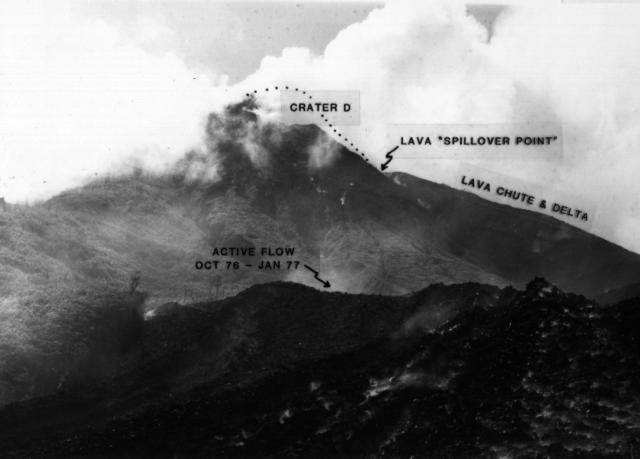 |
Figure 2. Photograph of the N side of Arenal, showing the still-growing N lava field. Crater D (summit crater) has greatly enlarged since the begining of current eruptions (1968). Photo taken by W.G. Melson, October 1976. |
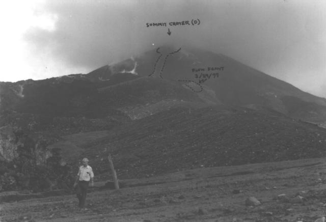 |
Figure 3. Photograph of the SW side of Arenal, showing the now inactive Crater A and an approximate outline of the active SW-moving lava flow as of 29 January 1977. Photo taken by W.G. Melson, 11 January 1977. |
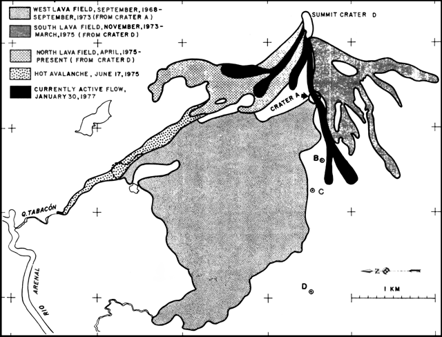 |
Figure 4. Preliminary sketch map of the N, S, and W lava fields at Arenal, showing lava flows and the hot avalanche deposit of 17 June 1975. Dates are approximate. Tilt stations B, C, and D are shown by circles. Grid markings refer to the 1000 Meter Transverse Mercator Grid, Zone 16, Clarke 1866 Spheroid (Fortuna, Costa Rica 1:50,000 Quadrangle). Adapted from a map prepared by Hugo T. Tims and provided by Jorge Umaña, Instituto Costarricense de Electricidad. Tilt station A, not shown in the map, is about 100 m S of the center of Crater A. Courtesy of W.G. Melson. |
Information Contacts: W. Melson, SI.
Map showing currently active lava flows
[A map was included (figure 4) with no accompanying report. The map was referenced in the previous report.]
Information Contacts: J. Umaña, Instituto Costarricense de Electridad (ICE), San José; W. Melson, SI, Washington DC.
Lava flows continue to advance
The following is from Boletin de Volcanologia No. 2 of the Volcanology Section, School of Geographical Sciences, National University of Costa Rica.
Lava extrusion and gas emission at Arenal continued through mid-October. A block lava flow descended NW from Crater C, near the summit at about 1,400 m elevation. By 15 July, this flow had bifurcated at about 1,100 m elevation, one arm moving N, the other W. Three months later, on 14 October, the front of the W arm had traveled 500-600 m from the point of bifurcation, to approximately 830 m elevation, and was about 15 m thick. The N arm had only advanced about 150 m because of damming by older flows. A large gas column from Crater C was also observed on 14 October.
William Melson notes that Crater C has merged with Crater D, the old summit crater, over about the past 5 years, forming a single much-enlarged summit crater breached on the NW. This crater is rimmed elsewhere by nearly vertical cliffs, up to an estimated 100 m high on the E side.
Information Contacts: J. Barquero H., Univ. Nacional, Heredia; W. Melson, SI.
Two years of tilt data summarized
In October 1976, four dry tilt stations were installed along a radial line on the W side of the volcano. Since then, these stations have been releveled at about 1-month intervals. Throughout the 2 years of measurement, Arenal has been emitting block lava flows from its summit crater, at largely unknown but widely ranging rates of emission. During this period each station has shown, on the average, continuing deflation. Figure 5 shows deflation along the approximately 40-m-long radial line at each station. As expected, stations closest to the volcano show the largest rate of deflation. Periods of rapid deflation in some cases correlate with times of high rates of lava emission.
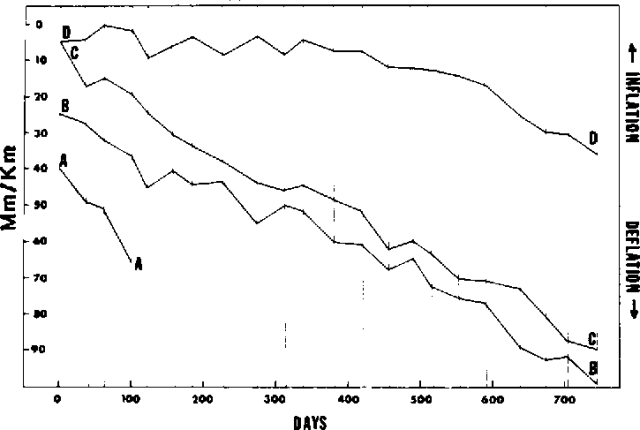 |
Figure 5. Inflation/deflation radial to Arenal's summit, in µrad, at tilt stations A, B, C, and D, from 19 October 1976 (day 0) to 3 November 1978. |
W. Melson notes that these data are consistent with a very shallow magma chamber 2 km below the surface, following the Mogi (1958) model of surface deformation over a spherical magma chamber and assuming maximum tilt at Station A. The extensive tilt measurements at Kīlauea show a quite different pattern than at Arenal. Specifically, deflation is extremely rapid, occurring over 12-hour to 6-month intervals, often accompanied by flank eruptions. At Arenal, more or less continuous deflation is accompanied by nearly continuous, long-term eruption of lava from the summit crater. At Hawaii, rates of lava emission are much higher than at Arenal, where basaltic andesite lavas (55% SiO2) contain about 50% phenocrysts and are clearly more viscous than the basalts of Hawaii. It seems reasonable to conclude that these different deflation behaviors are related directly to the different viscosities.
Access to Station A was blocked in February, 1977 by a new lava flow. Stations A, C, and D are tilt vectors oriented very close to, or on, the radial line. Station B is along a sharp ridge crest and only one component of tilt, along the ridge crest, (roughly on the radial line) can be measured.
The installation and relevelling were done by ICE topographers with advice from W. G. Melson and R. S. Fiske, in accordance with similar successful stations on Hawaii. Relevelling is done using a Wilde N3 level and precision stadia. The benchmarks at each station are in unconsolidated airfall, lahar, and avalanche deposits. Stability was obtained by driving 3 m-long, 2.5 cm-diameter steel rods into the ground. In most cases, it proved possible to drive these completely into the ground. The upper soil zones around each stake were excavated to about 1 m and filled with concrete. The top of each stake was then rounded, and between measurements is coated with grease and capped to prevent rusting.
Information Contacts: W. Melson, SI; J. Umaña and E. Evans, ICE.
Lava flow from the summit crater persists
The following is from the Institute of Volcanology, Boletín de Vulcanología, no. 3.
The block lava that had been flowing NW from the summit crater since mid-1978 stopped in November. However, a new block flow from the summit crater headed NE, reaching 1,100 m elevation (~500 m below the summit) by 2 December. This flow continued to advance in January and February.
Information Contacts: J. Barquero H., Univ. Nacional, Heredia.
New lava flow on W flank
The following is from the Institute of Volcanology, Boletín de Vulcanología, no. 4.
A team from the Institute of Volcanology climbed Arenal via the W and N flanks on 18 and 19 May. A new block lava flow from the summit crater was moving slowly down the W flank, where its front had reached 1,300 m elevation (~330 m below the summit). The NE-flank flow described in SEAN 04:03 had stopped at 1,000 m elevation, ~100 m below its elevation of early December 1978. Glow had been visible over the NE flank in March and April. Strong fumarolic activity obscured the summit crater. Within about 70 m of the summit on the N flank, numerous fumaroles emitted vapors ranging in temperature from 55 to 95°C.
Information Contacts: J. Barquero H., Univ. Nacional, Heredia.
New lava flow down SW flank
The following is from the Institute of Volcanology, Boletín de Vulcanología, no. 5.
A team from the Institute of Volcanology climbed the W flank on 20 September. The active block lava flow observed during the previous ascent on 18-19 May had stopped when its front reached an elevation of ~1,130 m on the W flank. A new block flow from the same crater (Crater C, at the W end of the elliptical summit crater area) had moved to about 900 m elevation on the SW flank. From there, a small lobe flowed W, reaching 700 m elevation by 20 September, with an approximate thickness of 20 m at its front.
During the team's ascent, a series of white vapor ejections occurred from Crater C, producing clouds that rose about 200 m above the summit. Each ejection was accompanied by loud noise. Collapse appeared to have taken place in the summit crater's W wall, which separates it from the active Crater C. Collapse debris fell above Crater C.
Information Contacts: J. Barquero H., Univ. Nacional, Heredia.
Lava extrusion continues; strong fumarolic activity
The following is from the Institute of Volcanology, Boletín de Vulcanología, no. 6.
During a late December visit to Arenal by Guillermo Avila and Jorge Barquero H., the SW-flank lava flow continued to advance at 20-25 m/day, more slowly than when the flow was higher, on steeper slopes. The flow, originating from Crater C, was channeled and composed of blocks ~0.5 m across. Vegetation surrounding the flow front was ignited by the heat of the lava. Since the last ascent of Arenal on 20 September, a new lobe had separated from the main flow and was moving downslope to the S.
Whitish vapor ejections from Crater C remained frequent, accompanied by loud noises and a very strong sulfurous odor. The strong fumarolic emanations forced Avila and Barquero to wear gas masks. A red glow was visible in the summit area at night. Major fissures in the upper wall of the summit crater threaten collapse of part of this wall into the vent area.
Information Contacts: G. Avila, ICE; J. Barquero H., Univ. Nacional, Heredia.
Lava extrusion continues
The following is from the Institute of Volcanology, Boletín de Vulcanología, no. 7.
The block lava flow [noted on 20 September 1979] continued to advance down the SW flank through the end of February. An inspection of the N flank on 23 January revealed no new lava flows on that side of the volcano. The rate of extrusion from Crater C had diminished in late January to the extent that it was difficult to see blocks moving in the central channel of the SW-flank flow. However, the extrusion rate increased in February, and lava overflowed its channel at about 1,200 m elevation. By 28 February, the new lobe had reached an elevation of ~1,000 m, with a front 50 m wide and 20 m high, partially covering an older flow. Emission of white vapor from Crater C also continued, accompanied by loud noise.
Information Contacts: J. Barquero H., Univ. Nacional, Heredia.
Lava extrusion continues
The following is from the Institute of Volcanology, Boletín de Vulcanología, no. 8.
The block lava flow extruded from the W end of the elliptical summit crater since mid-1979 continued to descend the SW flank through April, causing small forest fires. During a period of increased extrusion in February, the lava had overflowed its channel at about 1,200 m elevation and divided into seven subflows, partially covering three earlier flow deposits.
In early May, lava from the same vent began moving down the W flank. This flow, ~60 m wide and 20 m thick, reached the N rim of Crater A (~1,100 m elevation) by early July. An arm of the flow at 900 m elevation was still advancing on 10 July, although feeding from the vent had stopped.
Another flow, the 33rd since nearly continuous extrusion of block lava began in 1968, started to descend the NW flank in early July. On 11 July its front was at ~1,200 m elevation and was continuing to advance.
Further References. Guendel, F. and Malavassi, E., 1980, La actividad del volcán Arenal entre los días 15 al 20 de Agosto de 1980: Boletín de Vulcanología, no. 9, p. 3-4.
Wadge, G., 1983, The magma budget of Volcán Arenal, Costa Rica from 1968-1980: JVGR, v. 19, p. 281-302.
Information Contacts: J. Barquero H., Univ. Nacional, Heredia.
Lava extrusion continues; vigorous gas emission
The vent located at 1,450 m elevation at the W end of the elliptical summit crater area continued to emit block lava and vapor. The lava flow that began to descend the NW flank in early July had reached 1,100 m by November and continued to advance. Two other flows that had been active in July on the SW and W flanks had stopped advancing by November. A newer flow, the 34th since 1968, descended the W flank to 1,300 m elevation, where it bifurcated into lobes moving W and NW over the channels of older flows. The front of the W lobe was at 800 m elevation on 11 November, and the other (NW) lobe had reached 1,200 m elevation by 12 November. A mean velocity of 1.5 km/hour was measured on blocks in the central flow channel on the upper W flank.
The vapor emissions observed 15-20 August were a little more voluminous than normal, included small quantities of ash, and were accompanied by rumblings. The constant noise from the violently escaping gases was occasionally loud enough to be heard in nearby villages. Vegetation on the upper part of the volcano's E flank had been burned by the effects of the vapor eruptions. The loss of vegetation had noticeably augmented fluvial erosion.
In a separate communication, Jorge Umaña reports that as of early February Arenal continued to emit lava and vapor from the summit area. The gases had a high chlorine content.
Information Contacts: J. Barquero H., Univ. Nacional, Heredia; J. Umaña, ICE.
Lava extrusion continues; more chlorine in gases
Lava flow 34 continued to descend the W flank. By mid-March, the flow had divided into five lobes. Geologists noted an increase in the chlorine content of gas emitted from the summit area.
Information Contacts: J. Barquero H., Univ. Nacional, Heredia.
Lava extrusion continues
The following is from the Institute of Volcanology, Boletín de Vulcanología, no. 10, March 1981.
Lava extrusion continued from the vent at 1,450 m elevation at the W end of the summit crater. Portions of multi-lobed flow 34 were still advancing in early 1981. One lobe partially covered the W flank explosion crater that had formed in 1968 and extruded lava until 1973. At about 1,000 m elevation, this lobe separated into three sub-lobes, all of which flowed generally westward, reaching an elevation of about 900 m by late February. Two other lobes had halted, one in December 1980 at 700 m elevation, the second in January 1981 at 750 m elevation.
Information Contacts: J. Barquero H., Univ. Nacional, Heredia.
Lava flows and incandescent tephra; lava dome obstructing active vent deflates
In June 1979 and again in April 1980, the active vent was obstructed by a lava dome. Lava extruded from the dome flowed down the flanks, and gases (table 2) with temperatures between 930 and 954°C escaped at low pressure from radial fissures in the dome. Beginning in March 1981, violent degassing of the upper part of the conduit ejected large vapor columns, accompanied by strong detonations heard in La Fortuna, 6 km to the E. The vapor columns occasionally included fine tephra and bombs, which fell as far as 100 m from the crater rim. Incandescent tephra was sometimes observed at night.
Table 2. Analysis of the anhydrous component (H2O = 94%) of one of 60 samples collected from fissures in Arenal's dome between June 1979 and October 1980. Courtesy of J.L. Cheminee.
| Component | Amount |
| H2 | 8% |
| CO2 | 50% |
| SO2 | 37% |
| CO | 0.27% |
| H2S | 900 ppm |
| CH4 | 120 ppm |
In May 1981 the dome deflated, reopening the active vent's central conduit. At about the same time a multi-lobed flow, fed by the dome for the past several months, stopped advancing down the W flank. Later in May, block lava overflowed the S wall of the vent and began to move downslope at 50 m/hour in a channel 20 m wide. The flow split into two parallel lobes at 1,200 m elevation. The front of one lobe halted at 500 m elevation on the S flank, but the second lobe continued down the SW flank. Vapor emission continued to kill vegetation on the N and E flanks, resulting in increased erosion that carved large gullies.
An ascent to the crater area 25 June revealed a new flow (the 36th since 1968) descending the W flank. Continuous vigorous emission of gas and fresh tephra (basaltic andesite with plagioclase phenocrysts) was punctuated 1-3 times per day by stronger explosions that ejected bombs and blocks to roughly 200 m above the crater rim. The stronger explosions, which typically occurred after periods of decreased degassing but without immediate warning, kept geologists from getting close to the crater. A network of five radon-monitoring stations were installed on the volcano, in cooperation with Michel Monnin, Univ. of Clermont-Ferrand.
Information Contacts: J. Barquero H., E. Malavassi R., Univ. Nacional, Heredia; J. Cheminée, IPG, Paris; H. Delorme, Univ. de Paris; G. Avila, F. Guendel, ICE.
Block lava emission continues from summit crater
Block lava emission continued from the single crater near the summit at a rate of ~1 m/hour. By 3 December this flow had reached a cliff SW of the crater, and incandescent material cascaded in spectacular avalanches from the flow front. A continuous white gas column was only briefly observed due to poor weather conditions at the summit.
Information Contacts: R. Stoiber, S. Williams, H.R. Naslund, J.B. Gemmell, and D. Sussman, Dartmouth College; E. Malavassi R. and J. Barquero H., Univ. Nacional, Heredia.
New lava flow moves down SW flank in January
Lava continued to emerge from the active vent (Crater C). In January, a new lava flow, the 38th since 1968, started to move down the SW flank. By April, the flow front had reached an elevation of ~700 m. Continuous gas emission produced a vapor column that was always present over the active vent.
Information Contacts: J. Barquero H., Univ. Nacional, Heredia.
Lava flows and gas explosions
The following is a report from Dartmouth College geologists.
"A blocky lava flow continued to descend the upper slopes. On 17 November, a short, very slow-moving flow descended barely a hundred meters from the summit on the W side. This flow was much like others of recent months, slow-moving and not far-reaching, and the summit elevation had been built up as a result. By 27 November, a new flow had moved 250 m down the NE slope toward the head of the Río Tabacón, where a small nuée ardente eruption killed one and injured another in 1975. This flow was moving at a velocity more like that observed in November, 1981 (~1 m/hour).
"Numerous loud gas explosions could be heard during several days of observation. SO2 output, as determined by COSPEC, was extremely small considering the active state of the volcano. [Total SO2 output was about a quarter of the 200 ± 30 metric tons/day reported by Casadevall and others (1984) for Arenal in February 1982.] Large areas of the volcano's lower slopes were covered by a thin haze of blue gas suspected of being HCl-rich."
Reference. Casadevall, T., Rose, W.I. Jr., Fuller, W., Hunt, W., Hart, M., Moyers, J., Woods, D., Chuan, R., and Friend, J., 1984, Sulfur dioxide and particles in quiescent volcanic plumes from Poás, Arenal, and Colima volcanoes, Costa Rica and México: JGR, v. 89, no. D6, p. 9633-9641.
Information Contacts: R. Stoiber, S. Williams, H. Naslund, C. Connor, J. Prosser, and J. Gemmell, Dartmouth College; E. Malavassi R. and J. Barquero H., Univ. Nacional, Heredia.
Lava flows remain active
The lava flow that had advanced down the SW flank since January stopped in August. A new lava flow, the 39th since 1968, began descending the SW flank in August. In early September, the front of its main lobe stopped at an elevation of ~700 m, but another lobe continued to move SW until November. In mid-November, another new flow began advancing NW. On 18 November, its front had reached an elevation of ~1,300 m. Vapor emissions and gas explosions continued in the active crater.
Information Contacts: J. Barquero H. and E. Malavassi R., Univ. Nacional, Heredia.
Lava extrusion continues
By late March, the lava flow that had been advancing down the NW flank along the Río Tabacón had stopped. However, a new flow was emerging from the active crater and had advanced a short distance over its predecessor. Lava extrusion from the summit area has produced more than 40 discrete flows.
Information Contacts: E. Malavassi R., Univ. Nacional, Heredia; J. Prosser, Dartmouth College.
Lava flows active on the NW flank
The lava flow that began to move down the NW flank in mid-November continued to advance very slowly. By 5 April, its front was at 700 m elevation, but it was being overridden by a new faster-moving flow (the 41st since 1968) which had reached 1,200 m elevation. Gas emission remained constant from the active crater.
Information Contacts: J. Barquero H., J. de Dios Segura, Univ. Nacional, Heredia.
Continued lava extrusion
The lava flow that was advancing rapidly down the NW flank in April stopped in July with its front at an elevation of 625 m. A new flow, the 42nd since 1968, began to emerge in July and by September had reached 1,380 m elevation. Gas emission was continuous and strong rumblings were heard.
Information Contacts: J. Barquero H., E. Fernández S., Univ. Nacional, Heredia.
43rd to 46th lava flows since 1968
Lava extrusion continued from the vent at 1,450 m elevation. The lava flow that had been active in September 1983 stopped advancing in October. During the same month, a new flow (the 43rd since 1968) began to emerge, moving NW before halting at 980 m elevation in November. Another flow (no. 44) started to advance NW in December, remaining active until February, and still another flow moved N between January and March. Extrusion of flow no. 46 started in March and it continued to travel westward late in the month. Rumblings, or sounds similar to those produced by jet aircraft, were often heard in the crater.
Information Contacts: J. Barquero H., E. Fernández S., Univ. Nacional, Heredia.
Lava production slows as strong tephra ejection begins
The following is from R. Van der Laat. "An increase in the activity of Arenal, in the form of eruptions of ash and large pyroclastics, was observed beginning the first week in June. A small increase in the crystallinity and quantity of silica in the lava, signs of a greater although low viscosity, may explain the increase in the intensity and frequency of eruptions of ash and bombs originating in the active crater. This coincides with a clear diminution in the movement of lava flow number 49 with an active front on 10-11 July at about 1,100 m elevation (400 m below the level of the active crater; figure 6). The frequency of the eruptions was approximately every 30 minutes. All emitted gases and about every fourth one produced ash and bombs accompanied by rumbling. The size of the ash eruptions was medium to small, reaching a mean maximum height of 800 m, and ashfall extended some 10 km W to SW of the active crater. The large pyroclastics did not reach farther than 1 km (on the flanks of the volcano, figure 6).
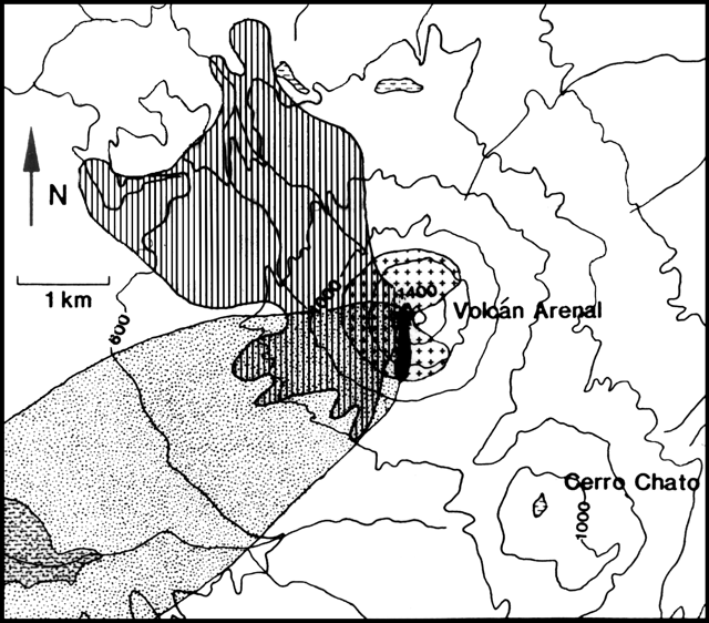 |
Figure 6. Map of Arenal and vicinity. Countour interval is 100 m. Lakes are indicated by a horizontal line pattern. The area covered by lava since the eruption started in 1968 is shown by vertical lines, the most recent lava flow by heavy shading, and the zones of June-July 1984 ash and bomb deposition by stipple pattern and crosses. Courtesy of R. Van der Laat. |
"Seismic data obtained in three visits to the volcano revealed a nearly total absence of volcanic earthquakes (other than seismicity accompanying the eruptions) but showed drastic changes in the eruptive character. Abundant on the seismograms were volcanic tremors and sonic waves that accompanied the eruptions of ash and bombs. Because bombs did not reach inhabited or farming-grazing areas and thanks to the great quantity of rain that continuously washes the ash, the risk at this time is minimal."
Strombolian activity was occurring during an 11-14 July visit to the volcano by Michael Carr. The following is from his report. "Explosions usually occurred erratically, but occasionally in a regular pattern with small explosions spaced at 10 ± 2-minute intervals. Weak explosions and 10-50-second periods of continuous pulsing gas emission occurred sporadically. Most of the explosions produced large blocks, which were red at night. Ashfall was intermittent and very light, even immediately downwind of the vent. A portable seismometer about 2.5 km from the crater, operated by Luis Diego Morales and Walter Montero of the Universidad Nacional, recorded B-type earthquakes during each explosion. The first seismic wave arrivals preceded the appearance of the eruption column by 2 seconds, indicating that the explosions originated at least 50 m below the crater rim. Until recently, lava flows were being nearly continuously produced from the crater, but the level of magma is now lower."
Information Contacts: R. Van der Laat, Univ. Nacional, Heredia; M. Carr, Rutgers Univ.
Strombolian activity and lava extrusion continue
The Strombolian activity that began to accompany the extrusion of block lava flows in June was continuing in mid-November. The eruptions were accompanied by strong rumblings. Blocks and bombs fell as much as 300 m from the crater. Ash was carried by the wind toward the W, to a distance of 5 km. No losses have occurred to agriculture or livestock. Nevertheless, because of the action of acid rain and ash, some vegetable species have chlorosis symptoms and fungus proliferation, both of which have affected plant development.
Lava flow number 49 ended its advance in October. A new flow (no. 50) began to advance toward the SW in October, stopping in November. Flow no. 51, descending toward the W, was still active in mid-November. Portable seismic stations have been operated periodically. They have not registered type A or B volcanic earthquakes, but only events produced by the explosions, and volcanic tremors of different character.
Information Contacts: Observatorio Vulcanológico y Sismológico, Univ. Nacional, Heredia.
Explosions; ashfall; lava flows remain in summit area
"Dartmouth geologists visited the volcano 3-4 December. Lava flows had reached Arenal's lower flanks earlier in the eruption, but lava now being extruded was restricted to the summit. Eruption noises were heard at approximately half-hour intervals, some as far as 5 km from the summit. They were accompanied by sounds of ejecta falling on the upper slopes. Light ashfall was observed 2 km from the summit. A local farmer reported that eruptions (perhaps mud pots?) had occurred in a small lake near La Fortuna, 6 km E of Arenal, but the report was not substantiated."
Information Contacts: B. Barreiro, R. Naslund, R. Stoiber, and P. Turner, Dartmouth College.
Strombolian activity and lava extrusion continue
In late February, a new lava flow was descending Arenal's N flank, filling gullies that had been formed by erosion. Summit area Strombolian activity was continuing, although explosions were not frequent. Explosions typically began with strong rumblings, followed a few seconds later by the ejection of bombs, blocks, and ash from the upper crater to a height of 2,000 m. The ash was carried by the prevailing winds toward the W, to a distance of 4 km from the crater. Blocks and bombs fell as far as 500 m from the crater. Some blocks reached 40 cm in diameter. The N and E flanks of the volcano are covered by trees, and falling tephra caused small fires that burned vegetation. Gas emission continued at the same rate as before.
Information Contacts: J. Barquero H. and E. Fernández S., Univ. Nacional, Heredia.
Lava extrusion
During July, two lava flows descended from the active vent. On the NE flank a flow that originated in April continued to advance. A new flow (the 55th since 1968) began erupting in July. Strombolian eruptions continued but were becoming less frequent. Accompanied by very strong rumblings, they produced small quantities of ash that were carried 3 km W and SW from the crater. Gas emission was continuous.
Information Contacts: J. Barquero H., E. Fernández S., Univ. Nacional, Heredia.
Lava flows and tephra ejection continues
Lava production continued through early November from the active vent (Crater C), feeding lava flows that advanced NW, W, and S. A dome has formed on the W rim of Crater C. Gas emission was continuous. The ejections of pyroclastic materials that began in June 1984 were also continuing in early November. Geologists noted that when the advance of the lava flows was slow, the explosions were strong and very frequent, whereas when much lava was flowing from the crater there were almost no pyroclastic ejections. There were strong explosions during the first week in October. A 50 x 60 cm bomb fell 1 km from the crater, forming an impact crater that measured 80 x 50 cm and 20 cm deep. A block with dimensions of 90 x 30 x 20 cm formed a 90 x 100 cm crater that was 30 cm deep; this block came to rest 20 m from its initial impact crater. Small quantities of ash were emitted. Prevailing winds carried the ash about 3 km W and SW.
Further Reference. Alvarado, I.G.E. and Barquero, R., 1987, Las señales sísmicas del volcán Arenal (Costa Rica) y su relación con las fases eruptivas (1968-1986): Instituto Costarricense de Electricidad, Departamento de Geología, San José, 33 p.
Information Contacts: J. Barquero H. and E. Fernández S., Univ. Nacional, Heredia.
Continued lava production; avalanches from flow fronts
"Arenal remained very active, with emission of lava from Crater C at 1,450 m elevation. Lava advanced towards the N, NW, W, SW, and S, with flow fronts reaching 900 m elevation. Frequent avalanches, from continuous to every 15 minutes or so, occurred from the flow fronts. Sporadic explosions ejected pyroclastic materials, with some blocks and bombs falling at 800 m elevation. Ash was carried by winds, mainly toward the W and SE, to 4 km distance. Gas and vapor emission was continuous."
Information Contacts: J. Barquero and E. Fernández, OVSICORI.
Increased seismicity with gas/ash emissions & lava flows
"Continuous eruptive activity at Arenal started in 1968 with a strong explosive phase and nuées ardentes, preceded by a seismic swarm lasting several days. The volcano then entered into an effusive phase with more or less continuous block lava flows and some small explosions. This activity was interrupted in 1975 by a new explosive phase that included hot avalanches. From 1976 through 1983 activity was mainly effusive, with numerous lava flows. In 1984, another moderate explosive phase lasted for 6 months. Normal effusive Strombolian activity occurred in 1985, with a moderate increase in October and November.
"This year, a moderate increase in Arenal's activity started 1 May, with a maximum of 25 volcanic earthquakes (B-type)/day associated with gas and ash eruptions, and with block lava flows. Countable events totalled 188 in May (figure 7). The maximum trace amplitudes of the earthquakes showed a rather important increase relative to previous months (figure 7), indicating an increase in the energy liberated by the volcano, perhaps due to the beginning of the rainy season. Activity was intermittent through mid-July; the number of events in June was 144 with a maximum of 16/day. Maximum daily amplitudes of volcanic tremor showed clear increases prior to days with a greater number of volcanic earthquakes (figure 7). So far the activity can be considered normal within the present active period."
 |
Figure 7. Seismicity at Arenal recorded at the FOR station during 1 May-15 July 1986. Daily number of B-type volcanic earthquakes (top), maximum daily amplitude of volcanic earthquakes (center), and maximum daily amplitude of volcanic tremor (bottom). Courtesy of R. Barquero. |
Information Contacts: R. Barquero, ICE.
Tephra eruptions and lava flows; seismicity declines
A moderate increase in seismic activity . . . continued until August, when seismicity began a gradual decline that persisted through the end of 1986. The number of explosive volcanic earthquakes (C-type) peaked during July with 261 events recorded at a rate of 8/day. Totals of 160 events were recorded in August, 89 in September, 100 in October, 85 in November, and 55 in December (figure 8, top). These earthquakes were associated with moderate eruptions of gas, ash, and bombs, and small block lava flows from the upper crater. Tremor activity declined after increases in May, July, and August (figure 8, bottom).
 |
Figure 8. Seismicity at Arenal recorded at station FOR during July-December 1986. Daily number of volcanic earthquakes (top) and maximum daily amplitude of tremor (bottom). Courtesy of ICE. |
A small volcanic debris flow, probably of low temperature, was generated in 1986 (possibly on 16 March). A new well-defined lava flow was observed in January 1987 on the NW flank. The flow descended to ~1,000 m elevation before stopping temporarily by the beginning of February. In early February, Strombolian explosions occurred every 2 hours. Continuous eruptive activity started in 1968 with strong explosions and pyroclastic flows. More than 60 lava flows have emerged from the summit crater since then.
Information Contacts: R. Barquero and Guillermo Alvarado, ICE.
Stronger explosions and seismicity; nuée ardents
Arenal remained active, with emission of lava from a summit crater (C) toward the N, NW, SW, and S. Vapor emission was continuous. During March, there was a small increase in activity, principally Strombolian eruptions. Ash was ejected to 1 km height and carried W by the prevailing wind. The largest material, blocks and bombs, fell on the flanks to 600 m from the crater. Numerous strong explosion earthquakes were recorded, and periods of harmonic tremor lasting up to 20 minutes were associated with the explosive episodes (table 3). Electronic tiltmeters on the E and W flanks have not shown significant changes this year.
Table 3. Daily number of seismic events and tremor duration at Arenal, 15-26 March 1987, recorded by a seismic station just E of the volcano.
| Date | Number of Seismic Events | Tremor Duration hours) |
| 15 Mar 1987 | 17 | 0.34 |
| 16 Mar 1987 | 16 | 0.40 |
| 17 Mar 1987 | 17 | 1.00 |
| 18 Mar 1987 | 10 | 6.20 |
| 19 Mar 1987 | 17 | 4.05 |
| 20 Mar 1987 | 19 | 0.30 |
| 21 Mar 1987 | 40 | 2.20 |
| 22 Mar 1987 | 66 | 1.60 |
| 23 Mar 1987 | 56 | 1.58 |
| 24 Mar 1987 | 47 | 2.25 |
| 25 Mar 1987 | 55 | 1.85 |
| 26 Mar 1987 | 37 | 1.00 |
On 18 March at 1005, a large 10-minute ash eruption occurred, and a small nuée ardente moved 500 m down the SW flank. The first material that fell (at the volcano's W base) was very fine ash that originated from the nuée ardente. Fifteen minutes after the start of the eruption, deposition of coarser-grained ash began, lasting 6 minutes. The ash column was carried some 10 km W by winds. The eruption was accompanied by a seismic event that lasted 2 minutes 42 seconds. Explosions continued about once an hour. On 22 March, the wind direction changed to the E, causing 2 days of ashfall in the town of La Fortuna . . . .
Information Contacts: J. Barquero, M. Protti, and E. Fernández, OVSICORI.
Earthquake swarm preceded 18 March eruption
Activity was at a low level during January with a total of 106 explosions (C-type earthquakes) recorded (figure 9). Daily maximum tremor amplitudes increased slightly. A significant increase in explosive (Strombolian type) activity occurred 11-14 February. A total of 377 explosion earthquakes were recorded in February; tremor remained at January levels.
 |
Figure 9. Seismicity recorded at Arenal at station FOR, January-March 1987. Number of daily volcanic earthquakes (top) and maximum daily tremor amplitude (bottom). Courtesy of ICE. |
The number of explosions decreased in March but their energy increased considerably; 231 events were recorded. Bombs were ejected at velocities of >100 m/s reaching 1,800 m NW and 1,000 m W of the active crater. Several explosions were recorded at seismic stations >100 km from the volcano. Daily maximum amplitudes showed a significant increase.
On 7 and 8 March, a shallow earthquake swarm was registered by National Seismological Network stations. The 15 tectonic-like events had epicenters 15 km E of Arenal. Three earthquakes were felt by residents of La Fortuna (figure 10) at MM II-IV. The strongest reached magnitude 4.2 (figure 9). On 18 March a large ash eruption occurred.
 |
Figure 10. Sketch map of Arenal and the surrounding area, showing locations of seismic stations and epicenters of the 7-8 March 1987 earthquake swarm. Courtesy of ICE. |
Information Contacts: R. Barquero and Guillermo Alvarado, ICE.
New lava flow; explosions decrease; tremor continues
The number of explosions decreased in May to 201 events (figure 11) that were mostly of low energy. Tremor remained at a normal level. During a helicopter flight over the volcano, two hot spots were seen in the active crater and an incipient lava flow extended NW.
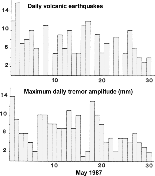 |
Figure 11. Seismicity recorded at Arenal at station FOR, May 1987. Daily number of volcanic earthquakes (top) and maximum daily tremor amplitude (bottom). Courtesy of ICE. |
Information Contacts: R. Barquero and Guillermo Alvarado, ICE.
Stronger explosions; ashfalls to 20 km W
During the first half of June, activity was at a relatively low level, with an average of four explosions daily (figure 12). A moderate increase was recorded beginning 17 June, with several significant explosions: 27 June, 1455; 28 June, 1503; and 29 June, 1655. These ejected substantial quantities of vapor, ash, and blocks. Ash clouds reached Tilaran, 20 km W of Arenal. Costa Rican geologists noted that such increases in activity have been a normal part of the current eruption.
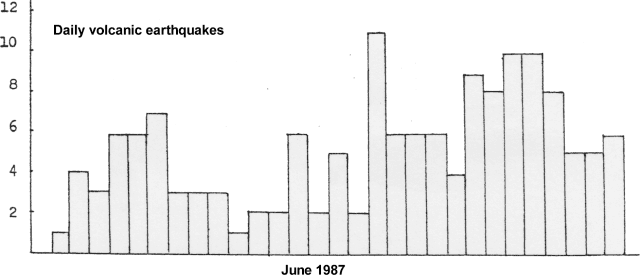 |
Figure 12. Daily number of Arenal's volcanic earthquakes recorded at station FOR, June 1987. Courtesy of ICE. |
Information Contacts: R. Barquero and Guillermo Alvarado, ICE.
Moderate activity continues; explosions increase
Activity continued at a moderate level during July (figure 13). The number of explosions increased to an average of 8/day, but explosion energy decreased. Maximum recorded explosion rates peaked at 15/day at the beginning and end of July (figure 14). Tremor amplitude showed a moderate increase around mid-month (figure 14).
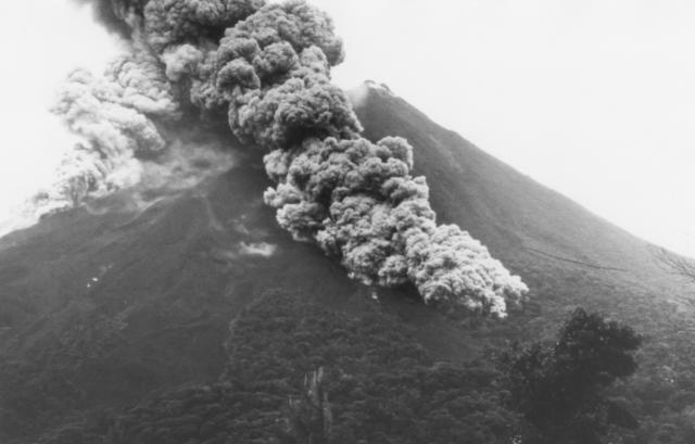 |
Figure 13. Nueé ardente descending the SSE slope of Arenal at 1631 on 13 July, taken from the Volcanological and Biological Observatory, 2.5 km S of the summit. Courtesy of W. Melson. |
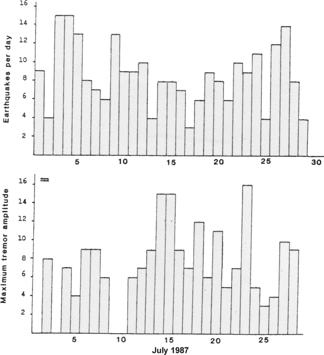 |
Figure 14. Seismicity recorded at Arenal's FOR station in July 1987. Daily number of volcanic earthquakes (top) and maximum daily tremor amplitude (bottom). |
Information Contacts: R. Barquero and Guillermo Alvarado, ICE.
Strombolian activity and lava flows; explosions decline
Strombolian activity persisted from Crater C with continuous emission of lava and gases, and sporadic ejection of pyroclastic material. The stronger June/July activity produced occasional nuées ardentes that extended ~500 m from the crater on ... 13 July at 1630 (burning 1/2 hectare of forest on the S flank) and 17 July at 1430. Ash emission also increased in June, with fine ash generally carried to ~4-5 km W and NW from the crater by the prevailing winds. Lava flows continued to descend the N and NE flanks. The incipient lava flow seen 23 May during a helicopter overflight continued to advance NW toward the Río Tabacón. At the end of July, its front was at ~1,000 m elevation, roughly 1 km from the summit.
Activity declined sharply in August. Only 21 explosion earthquakes were recorded compared to 248 in July, and tremor weakened considerably.
Information Contacts: J. Barquero, OVSICORI; R. Barquero and Guillermo Alvarado, ICE; G. Soto and L. Morales, Univ de Costa Rica.
Explosions increase slightly
Recorded explosions declined in August to fewer than 1/day, but increased to ~5/day in September and activity was moderately stronger by the first week in October. A M 5.7 earthquake on 4 October, centered in the Middle American Trench roughly 180 km WSW of Arenal, was not followed by changes in the activity of Costa Rican volcanoes. Intensities reached MM III-IV in Tilaran, 30 km W of Arenal, and MM IV in Santa Cruz, 45 km WSW.
Information Contacts: G. Alvarado and I. Boschini, ICE; J. Barquero, OVSICORI.
Seismographs record vigorous explosions
Vigorous explosions were reported by the beginning of October, continuing to average ~5/day through the month.
Information Contacts: I. Boschini and G. Alvarado, ICE.
Frequent explosions continue to eject ash and blocks
Eruptive activity continued in November. The volcano erupted 17 times during 14 daylight hours of observation 15-16 November. Intervals between eruptions varied from 15 to 150 minutes. Most were accompanied by loud explosions and rumbling. Clouds, often containing ash, rose 1,300-1,700 m above the summit. Summit eruptions caused light ashfall (grain size 0.25-0.50 mm) 4 km W, and threw incandescent blocks 900 m down the flanks. Very frequent rockfalls occurred on the NW side of the dome. Measurements indicated an SO2 flux of <100 t/d.
Information Contacts: E. Fernández, OVSICORI; B. Gemmel, H. Mango, K. Roggensack, R. Stoiber and other geologists, Dartmouth College.
Slight increase in explosions
Eruptive activity increased slightly in November, continuing the general rise that began in September. Volcanic earthquakes totaled 209 for November and explosions averaged 10/day. The strongest activity occurred 14, 18, and 23 November, with tremor amplitude reaching a maximum on the 23rd.
Information Contacts: G. Alvarado, ICE.
Continued lava production; nuées ardentes; ashfalls
Arenal's eruption continued, as lava descended from Crater C towards the N and NE; a small lava flow moved S in April. Occasional tephra eruptions were observed, some of which ejected considerable ash in March. On 11 March at 0954, a nuée ardente descended in two lobes, one toward the SW and the larger toward the S, reaching 800 m from Crater C. Ash was carried W by the wind, to 12 km from the crater. Flank vegetation was covered with ash, some of which remained on trees a month later. On 28 March at 1105, another nuée ardente was generated, again with two lobes to the NW and SW. The larger (NW) lobe advanced 500 m. Ash fell 10 km W of the crater. During a period of moderate explosive activity 3-9 April, there were 6-13 explosions/day. Activity declined considerably from 10 April, and on the 17th and 18th, for example, no explosions were seen or heard. At the end of the month, a slight increase was detected in volcanic noise or explosion shocks.
Information Contacts: J. Barquero and E. Fernández, OVSICORI; G. Soto, Univ de Costa Rica; G. Alvarado, ICE.
Explosions and lava flow; one climber killed
Activity at Arenal remained similar to that of previous years. Short lava flows were extruded, accompanied by periodic Strombolian explosions that averaged ~10/day on seismic records (figure 15). Earthwatch observers continuously recorded the number of Vulcanian explosions and estimated sound magnitudes 19-28 July. A total of 89 explosions were recorded during the 10-day period (figure 16), a decline from 418 during 28 April-9 May 1987, 395 during 10-19 July 1987, and 130 during 12-21 February 1988 (figure 17). Geologists noted that similar decreases during the 20-year eruption have been followed by renewed increases in the frequency of explosions. Between observations on 18 June and 18 July, a blocky lava flow had moved ~1 km S from the summit crater but had ceased moving by 18 July. On 16 June, geologists observed considerable searing of marginal forests caused by a number of hot avalanches that moved down the headwaters of the Río Tabacón, reaching 1-1.5 km from the summit. On 6 July, a climber died near Arenal's crater rim after being struck in the head by tephra. The victim and a companion had approached to ~3 m from the crater rim when the explosion occurred. The second climber escaped with first- and second-degree burns and a head cut; a third, who had not approached the crater, was uninjured.
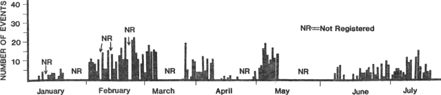 |
Figure 15. Daily number of volcanic earthquakes recorded at Arenal by station FOR, January-July 1988. Courtesy of Guillermo Alvarado I. |
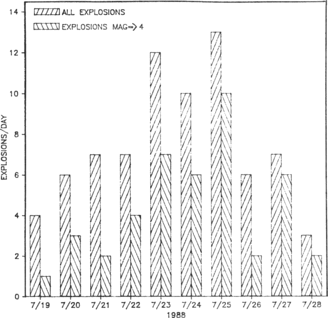 |
Figure 16. Total number of explosions and number of explosions with subjective magnitudes >4 at Arenal 19-28 July 1988, based on a qualitative sound magnitude scale of 1-10. Courtesy of W. Melson. |
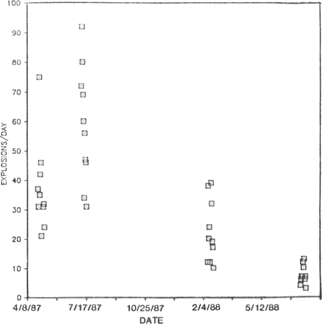 |
Figure 17. Explosions/day at Arenal during three observation periods, April 1987-July 1988. Courtesy of W. Melson. |
Information Contacts: W. Melson, SI; J. Barquero, R. Saenz, and E. Fernández, OVSICORI; G. Alvarado, ICE; The Tico Times.
Tephra ejection; ashfall on nearby town
Eruptions of pyroclastic materials continued, with ash carried W and NW by the wind. During the morning of 26 August, the wind shifted to the E, causing ashfall on the town of La Fortuna . . . .
Information Contacts: J. Barquero, E. Fernández, and R. Van der Laat, OVSICORI.
Explosive activity documented
From 13 to 21 September, the number, type, and estimated magnitudes of Arenal's Vulcanian eruptions were continuously noted by volunteers from the Smithsonian Research Expedition Program. Because of poor summit visibility, eruption type was recognized by sound signature. Eruptions (figure 18) consisted of explosions, intense block and bomb fountains (identified by "whooshing" sounds), and smaller rhythmic block and bomb fountains (weak "chugging" noises at ~1- to 2-second intervals). The eruption rate varied greatly but averaged 1.5/hour. Seismic energy release was greatest for intense block and bomb fountaining and much less for explosions. The frequency of explosions continued a 2-year decline, but intense fountains of bombs, blocks, and ash continued to increase in number. At 0910 on 17 September, a fountaining episode produced a hot fallback avalanche (~60,000 m3) that descended to 1.5 km S of the summit crater. Explosions ejected incandescent, highly phyric, viscous, basaltic andesite bombs and blocks to ~650 m from the crater, and rarely to 1 km. No lava flows were emitted.
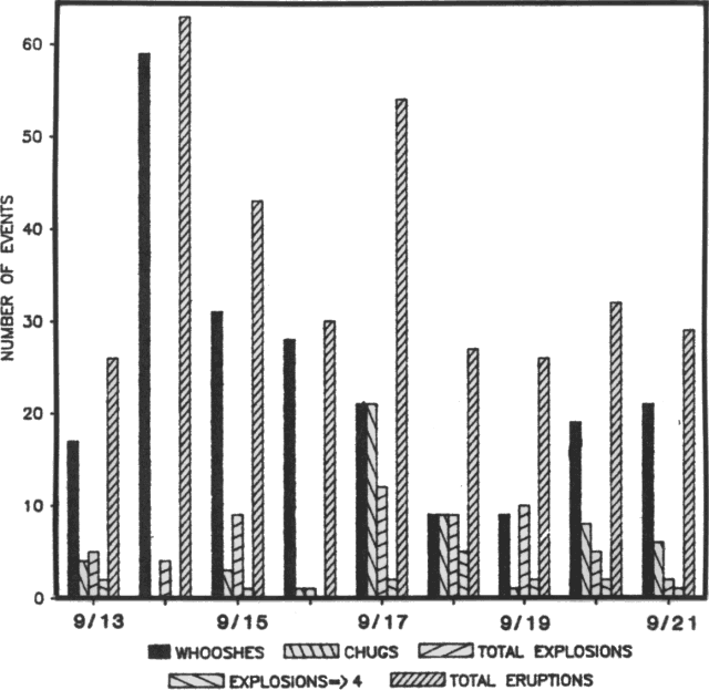 |
Figure 18. Number and type of emissions from Arenal's summit cone, 13-21 September, 1988. Courtesy of W. Melson. |
The activity continued to build a new cone (over Crater C) that reached 1,550 m elevation about 350 m W of the old summit cone, inactive except for numerous fumaroles. The old cone's walls, 1,633 m high prior to the 1968 eruption, continued to collapse, largely due to ballistic impacts from the explosions.
Acid rain within 2.5 km of the summit had pH values as low as 3.4. During the mid-September observations, the winds were typically from the W, contrary to the normal easterly trade winds. Ash frequently fell to the E, including the town of La Fortuna.
The Univ of Costa Rica reported that an average of 15 explosions were registered/day during the last week in September. The two main summit area fumaroles emitted gas that was predominantly white (water vapor) but included some basal bluish coloration, probably from sulfur compounds or chlorine.
Information Contacts: W. Melson, SI; G. Soto, Univ de Costa Rica.
Explosions eject blocks to 1 km from crater
Activity continued with sporadic explosions that were not accompanied by loud rumbling. Vibrations were occasionally felt on the volcano, but cloudy weather usually obscured the summit. Blocks fell as far as 1 km from the crater. On 10 January at 1442, several blocks struck near geologists working on the W flank, forming impact craters and burning plants.
Information Contacts: J. Barquero and E. Fernández, OVSICORI.
Continued Strombolian activity; small nuees ardentes
Arenal's Strombolian activity continued during the first 4 months of 1989. The number of small to moderate explosions increased in March, when a maximum of 42 daily volcanic earthquakes were recorded by the Instituto Costarricense de Electricidad (figure 19). Activity then gradually declined. Sporadic explosions continued in April, sometimes producing nuées ardentes that moved 800-1,000 m downslope, observed 6 April at 1341, and 12 April at 1134 and 1337. Lava extrusion was sporadic and the flows did not advance far.
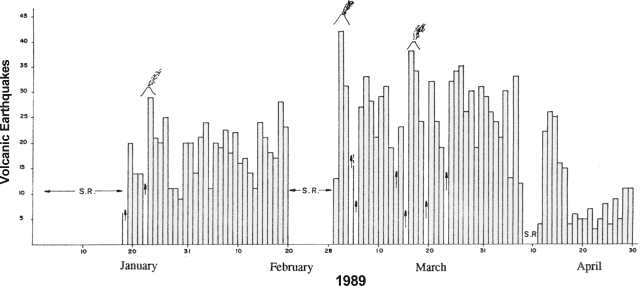 |
Figure 19. Number of volcanic earthquakes at Arenal, January-April 1989, recorded at the FOR station (Red Sismologica Nacional). Vigorous eruptive activity is marked by sketches of active cones; vertical arrows are minimum values indicating incomplete data (amplifier failure or masking by excessive volcanic noise); no data were collected during periods labeled "S.R." Courtesy of Rafael Barquero and Guillermo Alvarado, ICE. |
Information Contacts: R. Barquero and G. Alvarado, ICE; J. Barquero, E. Fernández, and V. Barboza, OVSICORI.
1987-89 explosive activity described
A cooperative study of Arenal by the OVSICORI and the SI, assisted by Earthwatch and Smithsonian Research Expedition volunteers, has completed eight periods of continuous day/night monitoring, generally of 10-14 days each, in the past 2 years. Most of the observations were made from the Arenal Volcanological and Biological Observatory, 2.7 km S of the summit, on the Marigold Genis macademia plantation. The following is excerpted from a report by W. Melson. A more detailed version will be published in Boletín de Vulcanología [see Further Reference, below].
"Over the past 2 years, Arenal's eruptions include the infrequent emission of lava flows and a variety of frequent pyroclastic eruptions that can be classified into three overlapping and sometimes sequential event types. Sounds were recorded at the Observatory using a standard cassette recorder and directional microphone. We also used a sound-level meter and a strip recorder to obtain time-sound intensity records of eruptions. Only rarely is Arenal's summit visible. Thus, we normally must classify eruptions by their sound characteristics (figure 20).
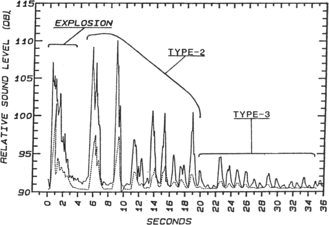 |
Figure 20. Arenal eruption sound sequence at 0407 on 3 April 1989, beginning with an explosion (type 1) and grading through type 2 to type 3. Sound level intensities were made from a tape recording and are thus only relative. The predominance of low-frequency components in the sequence is shown by comparing the unfiltered sequence (solid line) with the low-frequency filtered ( |
1. Explosions are intense, brief, energy releases, usually
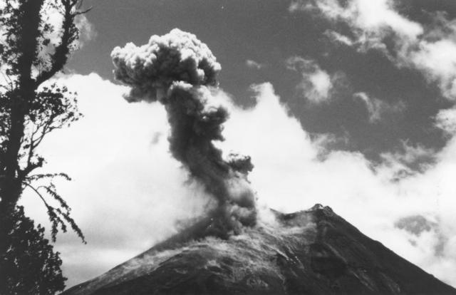 |
Figure 21. Explosion plume and impacting blocks, photographed from the Observatory, 2.7 km S of the new summit crater, on 15 April 1989 about 25 seconds after the onset of the explosion at 0759. Plume drift and tephra fall are to the W, the normal direction of trade winds at Arenal. |
2. Long-duration eruptions of blocks, bombs, and tephra may occur singly, or, more typically, in a series of varying loudness and ejecta volume. They are commonly associated with an intense, sometimes harmonic seismic event lasting >30 seconds. Pyroclastic flows associated with this type of eruption are of the fallback type, where tephra of low ejection velocity falls on the crater rim and coalesces into coherent flows. We have observed three pyroclastic flows over the past 2 years that descended >1 km from the crater; all were associated with a low-intensity sound signal but with a strong and sustained seismic signal. The sonic signatures are rich in low-frequency components (50 volume % crystals with compositionally evolved matrix glasses that are mainly dacitic.
3. A sequence of rhythmic gas emissions with or without ejection of small amounts of tephra. Frequencies are typically about 0.75-1.5 Hz between separate events. Within a given eruptive sequence, these are the highest-frequency, lowest sound-intensity, events.
"The frequency of eruptions varies widely with time. We have found no clear-cut cyclicity nor other obvious patterns in these data (figure 22). Over the past 2 years, the seven periods of close monitoring suggest a decline in the frequency of pyroclastic eruptions followed by a slight increase. During the April 1989 observations, the number of explosions (type 1) particularly increased. Small lava flows moving down the S slope also led to an increase in recorded rockslides. However, during the past 2 years, most of the lava flows have moved down the N slopes, many of them in the headwaters of the Río Tabacón; rockslides associated with their advance are not audible from the Observatory.
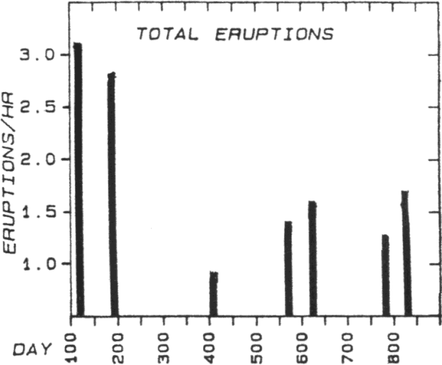 |
Figure 22. Average number of eruptions at Arenal per hour during each 10-14-day period of observation, 28 April 1987-April 1989. |
"The number of pyroclastic events decreased dramatically after about 15 April 1989, reaching the lowest level in the past 2 years. Only one explosion occurred during 5 days of close monitoring 30 June-4 July. During that time, intense lava fountaining in the summit crater was visible at night and at least two wide but thin flows were active on the N flank, in the headwaters of the Río Tabacón, with advancing flow fronts ~1,200 m below the new crater, now at ~1,600 m elevation. This is the second period of low pyroclastic activity associated with a high level of lava flow production. The first was recorded 9-19 February 1988, when an active lava flow had reached ~1,200 m elevation in the headwaters of the Río Tabacón. The rate of magma emission is far greater during times of strong lava emission than during even high levels of pyroclastic activity. It is likely that during periods of high rates of lava production, the conduit is essentially open, preventing formation of a plug by cooling and degassing, and hence the buildup of vapor pressure and attendant pyroclastic events.
"We find no consistent relationship between tremor levels and eruption frequency or type during our last two periods of close monitoring, except for Type 2 eruptions, which were most common at high tremor levels during both periods. Notably, explosions (Type 1 eruptions) occurred at minimal levels during tremor-free periods during the February expedition, but at maximum frequency during periods of maximum tremor in February."
The ICE reported that seismicity declined to a moderate level in June, with a mean of only three recorded volcanic earthquakes/day. However, there was an increase in the number of harmonic tremor episodes, related to lava degassing.
Further Reference. Melson, W., 1989, Las erupciones del Volcán Arenal, 1 al 13 de Abril de 1989: Boletín de Vulcanología (Univ Nacional, Costa Rica), no. 20, p. 15-22 (in Spanish).
Information Contacts: W. Melson, SI; V. Barboza, J. Barquero, E. Fernández, and R. Saenz, OVSICORI; R. Barquero and G. Alvarado, ICE.
Strombolian activity and seismicity increase; lava flow
The number of volcanic earthquakes at Arenal recorded by the Red Sismológica Nacional increased on 20 July, to a daily mean of 19 for the rest of the month. Seismicity was most frequent on the 26th, when 30 events were recorded. A moderate increase in Strombolian activity was associated with the enhanced seismicity. A small lava flow descended the NW flank during July.
Information Contacts: R. Barquero and G. Alvarado, ICE; G. Soto, Univ de Costa Rica.
Increased Strombolian activity; lava flows
Strombolian activity remained moderate through August. Some of the August explosions were accompanied by detonations that rattled windows in the town of Fortuna . . . . Ash columns rose >1 km above the summit and were carried by the prevailing winds toward the W flank. Blocks and bombs fell as far as 800 m from the crater. Lava flows advanced N and NE from the crater, and the NE flank lava caused small fires as it moved through the forest. The permanent Univ Nacional seismic station continued to record harmonic tremor and explosions. Average values for tremor rose from 16.8 hours/day in May to 22.5 in June and 23 in July before dropping to 20 in August. Explosions, on the other hand, increased to a maximum of 18.5/day in August (from 2.5 in May, 3 in June and 5.2 in July) (figure 23). Eruption signals were of low to medium frequency (2.5-5 Hz) with amplitudes of 6-40 mm. Red Sismológica Nacional instruments recorded an average of 27 volcanic earthquakes daily in August, with a maximum of 38 on the 13th.
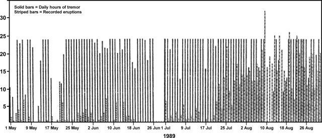 |
Figure 23. Daily hours of tremor (solid bars) and number of recorded eruptions (striped bars), May-August 1989 at Arenal. Courtesy of OVSICORI. |
Information Contacts: J. Barquero, E. Fernández, and V. Barboza, OVSICORI; R. Barquero and G. Alvarado, ICE.
Continued explosions; small block lava flows
The moderate increase in explosions and volcanic seismicity that began in July continued in September. Small block lava flows descended the N and NW flanks. The number of earthquakes averaged 17/day, with a daily maximum of 32.
Information Contacts: R. Barquero, ICE.
Volcanic seismicity and recorded explosions increase
At the end of September, seismic instruments at Arenal recorded a significant increase in the number of volcanic events and tremor episodes. Volcanic seismicity remained at an increased level during October, with a mean of 45 and a maximum of 64 volcanic events daily . . . . Recorded explosions also increased significantly, but in general were of moderate to intermediate magnitude.
Information Contacts: R. Barquero, ICE.
Stronger seismicity; Strombolian explosions; lava flows
During the first few months of 1989, activity at Arenal remained at its normal level. A small increase in Strombolian activity occurred in March, accompanied by as many as 42 volcanic events/day (figure 24), then declined rapidly, reaching a minimal rate in June with a mean of only 3/day. A renewed moderate increase in July was marked by stronger degassing associated with characteristic (blowing) sounds and more frequent tremor at a station (FOR, Red Sismológica Nacional) 4 km E of the crater. Activity built somewhat more during the first half of August, declining slightly before the onset of a stronger phase in late September. Daily seismicity reached its highest 1-day total, 64 shocks, on 11 October. Similar activity continued in November, with a mean of 40 earthquakes daily and a maximum of 52 (on the 21st), accompanied by significant tremor throughout the month.
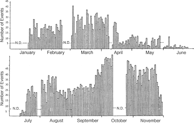 |
Figure 24. Number of volcanic earthquakes/day at Arenal, registered at Red Sismológica Nacional station FOR, 4 km E of the crater, January-November 1989. Periods when no data were recorded are marked N.D. Courtesy of R. Barquero. |
November field observations revealed small to moderate Strombolian explosions, most of which ejected ash columns to 1-1.5 km height. Winds carried most of the ash to the W, where it fell on Lake Arenal (extending from the W foot of the volcano), and on some occasions reached Tilarán (~30 km away). Block lava from the upper crater (Crater C, at 1,300 m elevation) moved down the NW and SW flanks, with blocks spalled from flow fronts reaching elevations as low as 750 m elevation in the Río Tabacón area. Geologists noted that a similar level of activity had not occurred since 1984.
Information Contacts: R. Barquero, ICE; G. Soto, Univ de Costa Rica.
Continuous tephra emission; blocks and bombs to 1,200 m from the crater; small nuées ardentes; flank lava flows
Continuous gas and tephra emission was accompanied by sporadic Strombolian eruptions. Blocks and bombs fell as much as 1,200 m from the active crater (C) to 880 m elevation. The activity occasionally produced small nuées ardentes, such as one observed on 9 November at 0230 that traveled some 400 m down the S flank from Crater C. Lava flows moved down the NE, N, and NW flanks. Some of the flows covered and burned vegetation on parts of the NE and N flanks. Fumarolic activity continued from the summit crater (D).
Winds carried ash columns toward the NW, W, and SW flanks, the area most affected by gases. During November, the mean pH of rain in this area was 3.8. Vegetation on the E flank continued to be affected by gases, acid rain, and falling blocks. The combination of vegetation damage, steep slopes, poorly consolidated material, and heavy precipitation has caused strong erosion, producing small cold avalanches in the canyons Calle de Arenas, Guillermina, and Río Agua Caliente.
During observations by geologists 9-10 January, loud explosions (Type 1 in 14:06) were heard, on average, about every 1.5 hours. Ash columns associated with five of the explosions were seen through breaks in the cloud cover. The loudest explosion during the period, on 10 January at 1720, was associated with the largest observed ash column, which rose ~1 km and was videotaped from the N side of Lake Arenal, ~20 km from the volcano. On 9 January at 2240, another Type 1 eruption ejected incandescent blocks and bombs onto the upper 2/3 of the N flank. A lava flow from the summit area descended the N flank, spalling blocks from its surface and levees.
Information Contacts: E. Fernández, E. Duarte, V. Barboza, J. Barquero, and J. Bravo, OVSICORI; S. Halsor, Wilkes Univ, USA; C. Chesner, Eastern Illinois Univ, USA.
Vigorous Strombolian activity; lava flows; little change in chemistry over last 3 years
A significant increase in Strombolian activity during March started with a corresponding increase in volcanic earthquakes at the beginning of the month. Between 20 and 24 March, substantially enhanced tremor accompanied lava production from Crater C. A small flow descended the NW flank toward the Río Tabacón, reaching ~700 m elevation. Lava continued to flow onto the NW flank in April, and a second flow began to advance down the S flank. Strombolian eruptions were larger and more frequent than in previous months and gas emission was continuous. Blocks and bombs fell 800-900 m from Crater C. Ash columns rose as much as 1 km and were carried by the wind toward the NW, W, and SW, the area most affected by acid rain. The activity occasionally produced small nuées ardentes.
Arenal remained highly active 1-22 April during 24 hour/day observations by Smithsonian Research Expeditions. Activity consisted of frequent pyroclastic events as well as production of small block lava flows that advanced down the S and WNW flanks. Flow movement down the NNW slope, the dominant direction during the past 3 years, had ceased. A pronounced leveed ridge had been produced by the most active (WNW) flow. Smaller flows were extruded from a small fissure ~100 m S of the summit crater rim, and a few hundred meters S from a spillover along the SSE part of the crater rim. Frequent explosions continued to eject blocks and bombs around the crater. Some fell more than a kilometer away, creating extremely hazardous conditions for ground observation of the crater area. Because the active flow fronts were all within the impact zone, there were no direct observations of flow rates.
Over the 23-day period, 807 pyroclastic events were recorded (figure 25), including sharp explosions [Type 1 in 14:06]; intense gas, block and bomb fountains [Type 2 in 14:06]; and rhythmic, less intense gas emissions, commonly accompanied by blocks and bombs [Type 3 in 14:06]. A "flashing arc", as described by Perret (1912) from eruptions at Vesuvius and Mont. Pelée, was observed from an explosion on 4 April at 1047 (figure 26). Two blocky pyroclastic flows moved down the S flank, each reaching ~800 m from the crater.
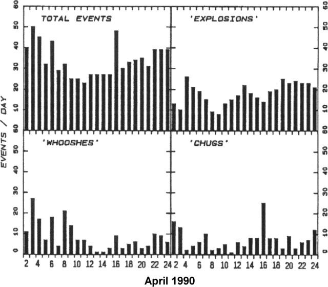 |
Figure 25. Number of pyroclastic events/day at Arenal, 2-24 April 1990. Poor weather conditions frequently prevented viewing of the summit, so different activity types were identified by sound: type 1 ('Explosions') are sharp explosions; type 2 ('Whooshes') corresponds to intense gas, block, and bomb fountains; type 3 ('Chugs') are rhythmic, less intense gas emissions commonly accompanied by blocks and bombs. |
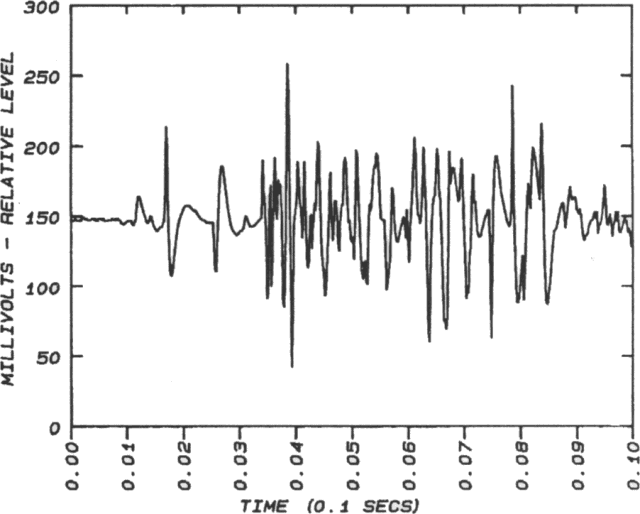 |
Figure 26. Airwave train of an explosion from Arenal that produced a "flashing arc" on 4 April at 1047. The tape recording from which this was derived was made 2.7 km S of the crater, where the event's maximum sound intensity was ~90 dB. |
The level of pyroclastic activity (figure 27), sampled at various times over the past 1,000 days at 10-23-day intervals, as well as lava flow directions and rates, continued to show wide variations on both day-to-day and longer time scales. However, the volume of individual lava and pyroclastic flows appears to have gradually declined over the 1,000-day period, with few reaching more than ~800 m from the summit crater. The crater appeared to contain at least two vents, with the S vent the source of much of the pyroclastic activity, while the lava flows emerged from the vent to its N and W.
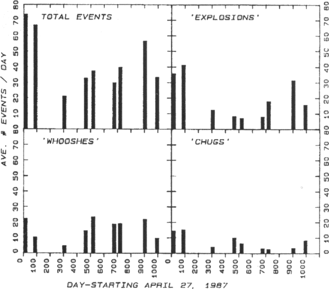 |
Figure 27. Comparisons of the number of pyroclastic events heard and (sometimes) seen at the Arenal Observatory, 2.7 km S of the summit crater, by Earthwatch and Smithsonian Research Expeditions volunteers since 27 April 1987. Activity types are as in figure 25. Sampling was over 10-22-day intervals during the periods shown. |
Chemical compositions of the highly phyric basaltic andesitic blocks and bombs (table 4) have remained essentially constant over the past 3 years, reflecting both a constant source composition and high magma viscosity. However, petrography has varied, particularly the glass/crystal ratio, high in bombs and near-vent lava flows and much lower in blocks.
Table 4. Compositions of 1987-89 eruption products from Arenal; XRF analyses by Joseph Nelen, SI. The August 1989 lava flow sample is from J. Barquero and E. Fernández. pf = bomb from pyroclastic flow; b = ejected block; B = ejected scoriaceous bomb; L = lava flow.
| Sample | EW51-2(pf) | EW2-105(b) | EW5-1(b) | EW5-2(B) | EW5-3(B) | 82389(L) |
| Date | 1986 | 07 May 87 | 20 Feb 89 | 20 Feb 89 | 20 Feb 89 | 23 Aug 89 |
| SiO2 | 54.84 | 54.90 | 54.82 | 54.52 | 55.09 | 55.82 |
| TiO2 | 0.64 | 0.61 | 0.62 | 0.62 | 0.61 | 0.63 |
| Al2O3 | 18.59 | 18.91 | 19.00 | 18.78 | 19.24 | 19.09 |
| Fe2O3 | 1.55 | 2.06 | 2.01 | 2.10 | 0.32 | 2.42 |
| FeO | 5.88 | 5.32 | 5.27 | 5.19 | 6.78 | 5.06 |
| MnO | 0.16 | 0.15 | 0.15 | 0.15 | 0.15 | 0.16 |
| MgO | 4.88 | 4.17 | 4.65 | 4.68 | 4.61 | 4.83 |
| CaO | 9.00 | 8.97 | 8.84 | 9.09 | 9.10 | 9.04 |
| Na2O | 2.88 | 2.92 | 2.92 | 2.89 | 2.92 | 3.30 |
| K2O | 0.66 | 0.65 | 0.66 | 0.66 | 0.65 | 0.71 |
| P2O5 | 0.18 | 0.18 | 0.18 | 0.19 | 0.18 | 0.21 |
| LOI | 0.22 | 0.28 | 0.00 | 0.16 | 0.25 | 0.20 |
| Total | 99.48 | 99.66 | 99.12 | 99.03 | 99.90 | 101.47 |
| Rb | 11 | 10 | 11 | 10 | 10 | 13 |
| Ba | 532 | 568 | 549 | 561 | 548 | 570 |
| Sr | 712 | 48 | 727 | 717 | 710 | 738 |
| V | 190 | 176 | 174 | 186 | 175 | 188 |
| Cr | 62 | 60 | 57 | 59 | 60 | 46 |
| Ni | 30 | 29 | 28 | 29 | 30 | 32 |
| Zr | 46 | 48 | 46 | 47 | 44 | 73 |
Reference. Perret, F.A., 1912, The flashing arcs: a volcanic phenomenon: American Journal of Science, ser. 4, v. 34, p. 329-333.
Information Contacts: W. Melson, SI; E. Fernández and J. Barquero, OVSICORI; Red Sismológica Nacional, ICE; Escuela Centroamericana de Geología, Univ de Costa Rica.
Lava flows; small Strombolian explosions; strong degassing and acid rain
Activity was moderate during May, with intense fumarolic activity and small Strombolian explosions from the active crater (C). Weak degassing, rich in meteoric water vapor, continued from the summit crater (D). Wind was blowing towards the NW, W, and SW. Vegetation on the NW and SW flanks was most affected by acid rain and falling blocks, with much of the vegetation high on the volcano in the process of dying. The lava flow that had descended the NW flank over the past few months had reached 750 m elevation and had a four-lobed front. Two new blocky lava flows from crater C had begun to descend toward the NW and the SSW.
Seismic activity associated with the volcano was at normal levels with an average of 15 events/day. Some were associated with the small to moderate Strombolian explosions that produced clouds of ash and vapor not exceeding 1 km height. Tremor related to degassing was also recorded. Seismic activity was most frequent on 12 and 15 May, when 42 and 38 earthquakes were registered respectively. Strong erosion due to heavy rainfall on unconsolidated material caused a number of small avalanches in the Calle de Arenas (E flank) and Guillermina (NE flank) quebradas (streams) and the Agua Caliente river (SW flank).
Information Contacts: R. Barquero and G. Soto, ICE; E. Fernández, J. Barquero, and V. Barboza, OVSICORI.
Pyroclastic activity resumes after brief pause; lava flows
Strombolian activity and lava emission continued during the end of May and through the end of June. Three new lava flows were noted on 6 June, extending as much as 300 m from the active crater's S rim; one flow was still advancing a few meters/day. Several older lava flows continued to advance, and the NW lava flow continued to build a delta in the southern headwaters of the Rio Tabacón, roughly 1 km from the summit. This and other flows are continuing sources of small block and ash flows.
A cessation of pyroclastic activity, similar to that of July 1989, lasted from 28 May to 16 June. The resumption of pyroclastic activity was preceded by an increase in seismicity (figure 28) and accompanied by a moderate increase in tremor. The number of earthquakes/day peaked on 17 June. The renewed pyroclastic activity included Strombolian explosions, sometimes intense, that occurred every hour to few hours, ejecting blocks to several hundred meters height. The explosions were accompanied by other pyroclastic events, identified by sound characteristics as intense gas, block, and bomb fountains, or less intense emissions of the same components. On 21 June around 1900, a particularly intense episode of fountaining was observed.
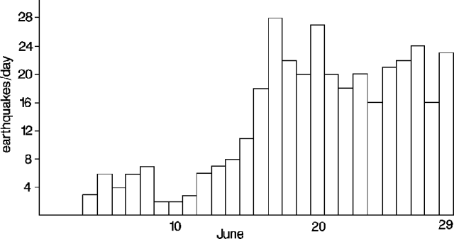 |
Figure 28. Number of earthquakes recorded at Arenal by the Univ de Costa Rica, June 1990. |
Information Contacts: W. Melson, SI; G. Soto and R. Barquero, ICE.
Continued Strombolian and effusive activity; strong gas emission
Strombolian and effusive activity accompanied by strong emissions of vapor and gas continued through July. Small block and ash flows were observed, principally on the NW flank where the active lava flows are situated (figure 29). The daily average number of volcanic earthquakes was 20 (figure 30), similar to the second half of June. A significant increase in harmonic tremor was noted.
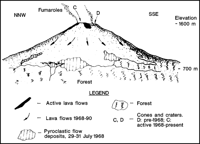 |
Figure 29. Sketch of the profile of Arenal, showing the location of lava flows and pyroclastic deposits. Figure by G. Soto, from a photograph taken by Rafael Barquero on 28 June 1990. |
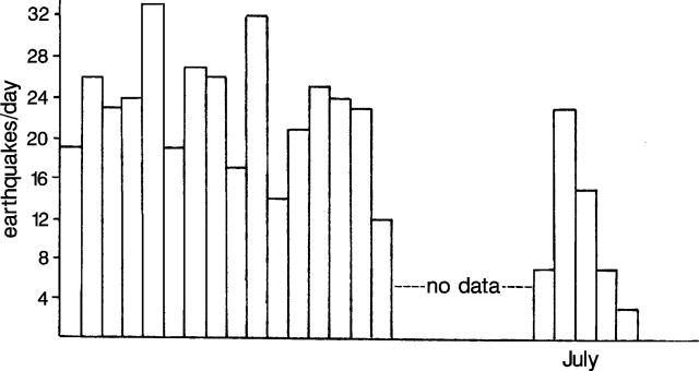 |
Figure 30. Number of earthquakes recorded at Arenal by the Univ de Costa Rica, July 1990. Courtesy of R. Barquero and G. Soto. |
Information Contacts: R. Barquero and G. Soto, ICE.
More frequent explosions; lava flow remains active
An average of 24 explosions/day, with a maximum of 41 (12 August), were recorded during August; June and July averaged 20 explosions/day. The Strombolian explosions ejected material to 1,000 m above the crater. "Fountains of bombs," without corresponding explosions, were noted 14 and 17 August. In addition to the explosions, tremor activity increased, especially between 17 and 21 August. Crater gas emissions appeared to be water-rich and an active lava flow on the NW flank reached 1,200 m elevation.
Information Contacts: G. Soto, ICE.
More frequent explosions; lava extrusion continues
Strombolian, effusive, and fumarolic activity continued through September. During August, lava descended the SW and S flanks and small nuées ardentes originating from the crater were periodically observed. Explosive activity produced an ash column (to 1 km above the crater) that was carried predominantly NW, W, and SW by the wind, and ejected blocks and bombs to 800 m from the crater. Flank vegetation continued to be affected by ashfall. Heavy rainfall and steep slopes caused small avalanches in the Calle de Arenas (E flank) and Guillermina (NE flank) quebradas (streams), and the Agua Caliente river (SW flank).
Explosive activity increased . . . to a maximum of 63 explosions/day, on 18 September. An average of 40/day were recorded during the last half of September. On 27 September, an increase in volcanic tremor was detected, with episodes of continuous tremor lasting up to 10 hours.
Information Contacts: G. Soto and R. Barquero, ICE; J. Barquero, E. Fernández, and V. Barboza, OVSICORI.
Strombolian activity; lava flows; small nuées ardentes
Strombolian activity and lava production continued, and occasional small nuées ardentes were observed during October. An average of 18 explosions (with three or four strong events) were recorded daily (figure 31) . . . . Explosions ejected blocks and bombs that were deposited to ~1 km from the crater, and produced ash columns 1 km high. White and occasionally bluish gas plumes were carried NW, W, and SW; acid rain continued to cause damage. At the end of October, two blocky lava flows were observed extending down the NW and SW flanks.
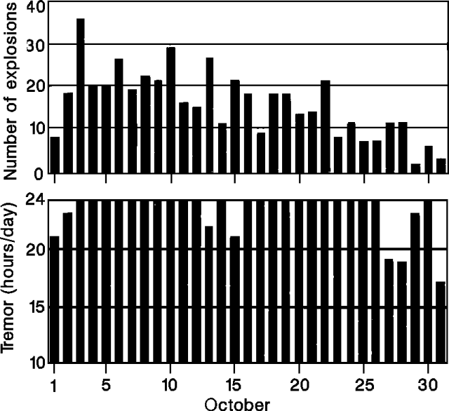 |
Figure 31. Number of explosions/day (top) and hours/day of tremor (bottom) recorded at Arenal by the Univ Nacional, October 1990. |
Tremor was nearly continuous, averaging 23 hours/day (figure 31), and increased in intensity towards the end of the month as the number of explosions decreased. Deformation measurements indicated continued deflation of the volcano since 1986, with occasional pulses of inflation during explosive stages (figure 32). The area around the active summit crater (C) continued to grow by accumulation of pyroclastic materials. The rate of this accumulation, which totaled 9 m from early 1987 through May 1988, has decreased (figure 33).
 |
Figure 32. Electronic tilt measurements at Arenal, January-October 1990. Courtesy of the Univ Nacional. |
 |
Figure 33. Growth of the active crater at Arenal, April 1987-August 1990. Courtesy of the Univ Nacional. |
Information Contacts: J. Barquero, V. Barboza, E. Fernández, and R. van der Laat, OVSICORI; G. Soto and R. Barquero, ICE.
Strombolian activity and lava production; seismicity dominated by E-W motion
Strombolian activity, with small explosions, lava extrusion, and voluminous gas emission, continued during November. The following is a report by W. Melson.
"The volcano was continuously monitored, seismically and by direct observations from the Arenal Observatory 24-27 November. During this period, lava flow emission was continuous down the S and SW slopes, none reaching farther than 300 m below the summit (~1,300 m elevation). The volcano was usually obscured by clouds, but changing rates of flow advance were evidenced by the frequency of audible and sometimes visible avalanches that ranged from ~1-20/hour from the lava fronts on the oversteepened near-crater slopes. We did not determine whether flows were simultaneously active on the N and NW slopes. No significant pyroclastic events, such as explosions, occurred during this interval.
"Seismicity was marked by frequent intervals of intense harmonic tremor. Digital seismic recordings (figure 34) using a 3-component Mark L-4 3D geophone revealed the dominance of E-W horizontal motions, typically at 1-2 Hz, accompanied by very little vertical motion, and sometimes completely without vertical motion. The motion may reflect sub-horizontal flow of the viscous andesitic magma in an E-W subvolcanic conduit."
 |
Figure 34. Three-component seismogram of harmonic tremor at Arenal, November 1990. Courtesy of W. Melson. |
Information Contacts: W. Melson, SI:G. Soto and R. Barquero, ICE.
Strombolian explosions resume as seismicity increases; lava flows
Lava and gas emission continued during December, although there was an absence of explosions and only sporadic chugging noises (rhythmic block and bomb fountains) were heard. One group of small explosions was recorded by seismograph on 16 December. Strombolian explosions reappeared 10 January, throwing blocks and bombs ~1 km from Crater C. On 15-17 January, explosions were observed at a rate of 2-3/hour, with several stronger explosions producing ash columns to 1,000 m height. During January, the plume averaged 700 m high and was carried predominantly to the SW, W, and NW, over the region most affected by acid rain. A pH of 4.62 was measured in this area. Ash fell 7 km from the summit (on Lago Arenal and the Sangregado dam). Lava traveled down the N, NW, SW, and S flanks of the volcano, with the N and NW flows reaching ~900 m length by the end of January. Seismicity increased in January (figure 35). Nearly continuous tremor was recorded 2-3, 8-9, 10-17, 20-24, and 26 January.
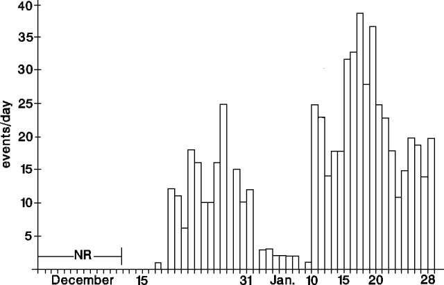 |
Figure 35. Daily number of earthquakes at Arenal, December 1990-January 1991. Courtesy of G. Soto. |
Information Contacts: G. Soto and R. Barquero, ICE; M. Fernández and W. Rojas, Univ de Costa Rica; J. Barquero and E. Fernández, OVSICORI.
Explosions continue
During February, explosive activity continued, with an average of three recorded explosions daily. Seismic activity was at low levels (figure 36). Strong emissions of water-rich gas were accompanied by prevalent volcanic tremor.
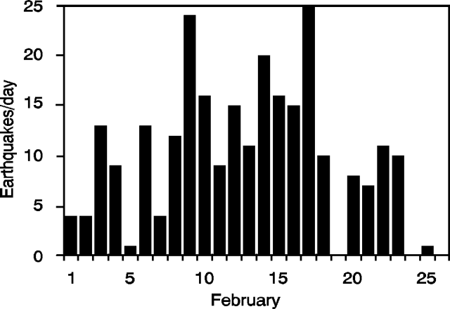 |
Figure 36. Daily number of earthquakes at Arenal, February 1991. Courtesy of Rafael Barquero and Mario Fernández. |
Information Contacts: R. Barquero, ICE; M. Fernández, Univ de Costa Rica.
Strombolian activity; explosions; lava extrusion
Strombolian activity, with sporadic small explosions, lava extrusion, and voluminous gas emission, continued during April. Tremor, associated with lava extrusion, dominated seismicity during the first half of the month. Following 15 April, the number of explosions increased and tremor diminished.
The following is a report by W. Melson. "From 7 to 17 April, continuous 24 hour/day seismic, sound, and visual observations from the Arenal Observatory . . . revealed that; 1) blocky lava flows are moving down and have covered the S slope to about 900 m elevation. None are now active in the previous long-term channel on the N slopes into the Río Tabacón drainage; one small 200-m-long flow was active on the WNW slope. 2) The level of pyroclastic activity ranged from 3 events/day (10 April) to 46/day (14-15 April) (figure 37). 3) Episodic periods of intense harmonic tremor are common. Compared to 11 other periods of close monitoring, beginning in 1987, the pyroclastic activity is low (figure 38)."
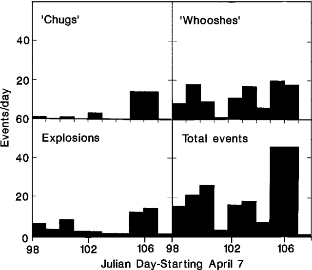 |
Figure 37. Daily number of pyroclastic events at Arenal, 7-17 April 1991. Event types are characterized by sound; 'Whooshes' are intense gas, block, and bomb fountains;'Chugs' are rhythmic, less intense gas emissions, commonly accompanied by blocks and bombs. Observations were made from Arenal Observatory Lodge, 2.7 km S of the summit. Courtesy of W. Melson. |
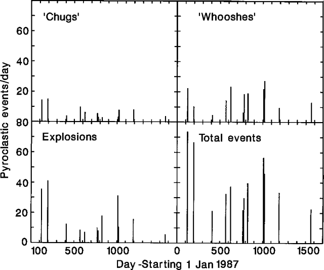 |
Figure 38. Average daily number of pyroclastic events at Arenal, during 12 approximately 10-day periods, 1987-91. Observations were made from Arenal Observatory Lodge (2.7 km S of the summit) by Earthwatch and Smithsonian Volunteer Expeditions personnel. Courtesy of W. Melson. |
Information Contacts: W. Melson, SI; V. Barboza, E. Fernández, J. Barquero, and R. Sáenz, OVSICORI.
Strombolian activity and seismicity increase, then decline; block lava flows on S and SW flanks
On 20 April, seismic explosion signals became moderately more frequent, and seismicity increased to >40 recorded earthquakes/day (RSN network). Seismicity was similar in May, with a daily average of 20 recorded earthquakes and a maximum of 43 (Univ Nacional network). Strombolian explosive activity was stronger, more voluminous, and more frequent, especially on 19-26 May when explosions vibrated windows and were heard 34 km SE (in Quesada). Several explosions were recorded at a seismic station 98 km away (Juan Diaz). Plumes rose to 1 km height above Crater C, depositing ash to Chambacú (17.5 km NE) and La Palma (4 km N). After 26 May, seismic and eruptive activity returned to normal levels. Gas emission continued with periodic, smaller explosions; plumes were carried predominantly to the NE, W, and SW. Block lava flows continued down the SW and S flanks, reaching 700 m elevation by the end of April.
Information Contacts: E. Fernández, J. Brenes, V. Barboza, and T. Marino, OVSICORI; R. Barquero, ICE.
Frequent explosions; new lava flow
Gas and vapor emission increased in June, as Strombolian activity decreased moderately from May. Seismometers recorded up to 65 explosions/day (on 22 June) and medium- and high-frequency tremor (>4 Hz) was recorded up to 24 hours/day (Univ Nacional network). Seismicity decreased from a daily average of 20 earthquakes in May, to 15 in June (Red Sismológica Nacional). Two lobes of lava continued down the S and SW flanks [but see July observations below], reaching and partially burning some of the upper forest. No serious mudflows had yet occurred, midway through the rainy season.
The following is from W. Melson, V. Barboza, and E. Fernández. "We monitored the activity of Arenal 24 hours/day, 7-17 July 1991. About 40 pyroclastic eruptions/day were heard, and their acoustic and seismic signals recorded at the Arenal Observatory lodge. This is the highest eruption frequency we have observed since 1-23 October 1989. The flows that advanced down the S slope during January-May 1991 have ceased moving, and a new flow sequence has begun spilling over the westernmost crater and moving down the WSW slope. Over 17 cm of rain and constant clouds prevented observations of the summit during most of this time."
Information Contacts: J. Barquero, E. Fernández, V. Barboza, R. Van der Laat, and E. Malavassi, OVSICORI; R. Barquero, Guillermo Alvarado, Mario Fernández, Hector Flores, and Sergio Paniagua, ICE; W. Melson, SI.
Increased Strombolian activity; seismicity
Strombolian activity, lava effusion, and seismicity all increased in July . . . . The number of volcanic earthquakes rose to a maximum of 59 recorded events/day on 11 July (figure 39). Seismometers recorded intermittent, vigorous tremor episodes, several hours long (6-hour average duration), especially at the beginning of the month.
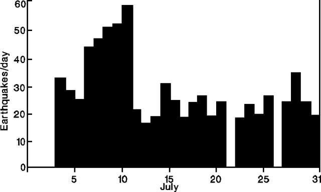 |
Figure 39. Daily number of earthquakes at Arenal, July 1991. Courtesy of the Instituto Costarricense de Electricidad. |
Information Contacts: R. Barquero and Guillermo Alvarado, ICE.
Explosions and seismicity decline; lava flows
An average of 3 explosions/day was recorded in August . . . . Seismicity also decreased, to a daily average of 20 earthquakes (figure 40). Fumarolic activity continued from the active crater, and lava flows continued to travel down the W and SW flanks of the volcano.
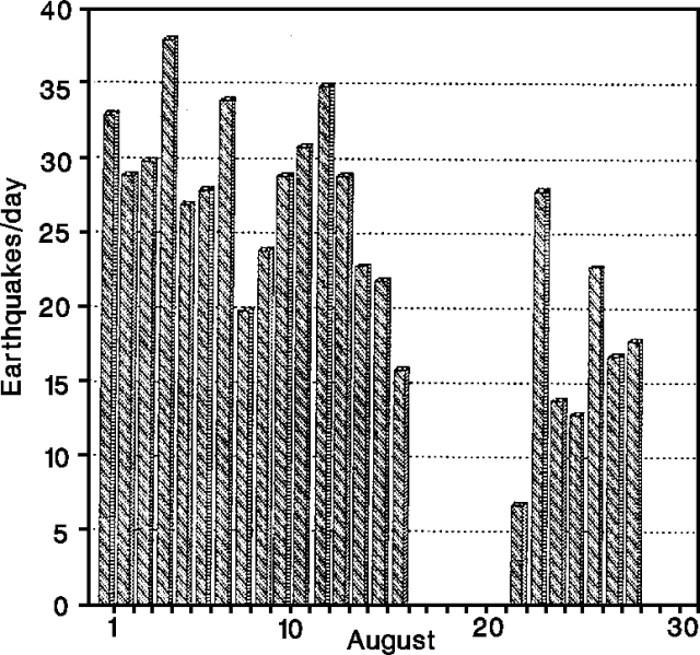 |
Figure 40. Daily number of earthquakes at Arenal, August 1991. Courtesy of the Instituto Costarricense de Electricidad. |
Information Contacts: R. Barquero and G. Soto, ICE; Mario Fernández, Hector Flores, and Sergio Paniagua, Sección de Sismología y Vulcanología, Escuela de Geología, Univ de Costa Rica, San José, Costa Rica.
Continuous gas and lava emission; occasional explosions eject large blocks
In September, continuous gas and lava emission were accompanied by sporadic block and ash ejections from Crater C (300 m W of the summit). Blocks landed as much as 1.2 km away (at 850 m elevation), and impact craters on the W flank reached 50 cm in diameter. Explosion columns rose to 1 km height and were carried by wind predominantly to the NW, W, and SW. Fumarolic activity was visible in the summit crater. Vegetation on the NE, E, and SE flanks continued to be affected by acid rain. Resulting erosion problems included small debris flows, especially on the NE flank (Quebrada Guillermina), E flank (Quebrada Calle de Arenas), and SW flank (Río Agua Caliente).
Information Contacts: J. Barquero, E. Fernández, V. Barboza, and J. Brenes, OVSICORI.
Block lava continues to advance; Strombolian explosions
Lava effusion continued through October. Two blocky flows were observed descending the WNW and SSW flanks in September, and continued to spall blocks from the advancing fronts in October. September fieldwork revealed that only blocks from the SSW-flank flow that was active in May and June reached the forest edge, and that the flow itself did not enter the forest. This flow was still hot in September and emitted vapor from its surface. Rapid erosion continued in flank ravines, carrying sediment downstream, where 14 cm of material has been deposited in Laguna Cedeño (2.5 km N) during the last 9 months.
Strombolian and fumarolic activity continued in Crater C, although explosions weakened at the end of September. During observations on 23-25 October, explosions were separated by 25-100 minutes. The daily number of earthquakes recorded by the ICE network was relatively low in September, averaging 10 (maximum 18), increasing to an average of 20 (maximum 55) in October. Significant tremor episodes occurred on 18-20 September, and 6, 12, and 26-29 October.
Information Contacts: R. Barquero and G. Soto, ICE.
Strombolian explosions and block lava
Lava and tephra emission continued in November from Crater C. The flow observed on the SW flank in September-October reached 850 m elevation. Strombolian explosions ejected ash, bombs, and blocks, producing 1-km-high columns and vibrating windows 2.7 km S of the crater (at Observatorio Vulcanológico y Biológico de la Finca La Macadamia). Gas and ash clouds were carried predominantly NW, W, and SW. Fumarolic activity continued in the summit crater (D).
Information Contacts: E. Fernández and J. Barquero, OVSICORI.
Vigorous lava production; pyroclastic flows; explosions eject large tephra
The lava flow active in September-November on the SW flank was different from other recent flows, being long, voluminous, and having well-defined levees. By the end of November the flow had divided into three lobes, of which two were still active to nearly 850 m elevation. The surface of the third lobe was cold, but it continued to emit vapor. Some of the nearby vegetation appeared scorched, but not burned. The flow extended ~1 km from the vent by 1 December, but no longer appeared active. Seismicity was at normal levels in November, with a daily average of 20 events and a maximum of 30 (on 7 November). Tremor activity increased on 1-4, 18, 21, 24, and 28 November.
The following was prepared by a UNESCO Regional Volcano Monitoring Workshop, organized by OVSICORI.
In mid to late November, a new lava flow began to follow the well-defined levees of the older flow, reaching an elevation of 1,150 m by 7 December. During fieldwork on 1-10 December, two types of pyroclastic flows were observed. The first type, produced by landslides from the active vent during vigorous lava emission, was generally restricted to the area close to the vent, with only two reaching moderate size (on 5 December). One of three portable seismographs on the volcano recorded a low- to intermediate-frequency signal with a 160-second duration, produced by the larger of the two moderate-sized pyroclastic flows. The second type, produced by landslides from an active levee due to high rates of extrusion, was always very small.
On 3 December, 31 seismic events were recorded (the most during the period 2-10 December; figure 41). Of these, 20 corresponded to explosions characterized by the ejection of blocks, bombs, gas, and ash, and occasionally pyroclastic flows. The others corresponded to low-frequency degassing events, which were more common after 3 December. Tremor increased after 7 December, reaching a maximum of 12 hours on 9 December (figure 42).
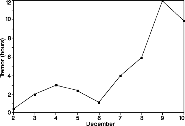 |
Figure 41. Daily number of seismic events at Arenal, 2-10 December 1991. Courtesy of OVSICORI. |
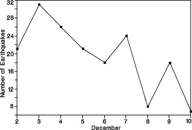 |
Figure 42. Hours of tremor/day at Arenal, 2-10 December 1991. Courtesy of OVSICORI. |
Deformation studies were conducted 2-10 December. Dry-tilt measurements indicated 6-8 µrads of subsidence at 2.5-4 km from the summit, and EDM measurements suggested contractions of 6-12 ppm along radial lines on the W and S flanks. This study occurred during the later part of one of the periods of inflation that have been associated with increases in explosivity. Growth of the active crater's (C) rim, monitored by vertical angle measurements, has averaged 63 cm/month over the past 5 years, reaching a maximum elevation of 1,657 m (24 m higher than the old summit rim of crater D, active [roughly 500 years ago]).
Information Contacts: G. Soto, R. Barquero, and M. Fernández, ICE; R. Van der Laat, OVSICORI.
Lava extrusion and Strombolian explosions continue
Lava emission and Strombolian explosions continued at Crater C in January; at Crater D, activity was restricted to fumarolic emissions. One lobe of the SW-flank lava flow, observed since September, was active in December, reaching 720 m elevation and covering ~100 m2 of grass. A flow that began in mid-to late November and followed the well-defined levees of the September flow, had reached 1,000 m elevation in January. A third flow was visible high on the NNW flank in January.
Explosions decreased in number and magnitude near the end of January (figure 43). White clouds associated with ash emissions rose >1 km and were carried NW, W, and SW. Acid rain, with pH as low as 3.1, continued to affect certain types of ferns, grasses, and heath. Measurements of pH at hot and warm springs on the N and NW flanks showed no significant changes from previous years.
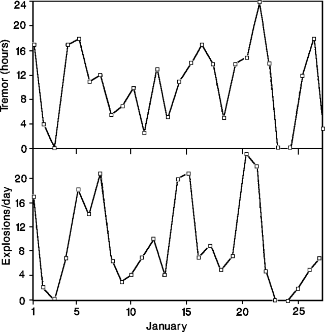 |
Figure 43. Daily hours of tremor (top) and number of explosions (bottom) recorded at Arenal, 1-27 January 1992. Courtesy of OVSICORI. |
Seismicity in January declined to 50% of December's recorded levels. Tremor became more frequent with continuous episodes of more than 24 hours.
Information Contacts: E. Fernández, V. Barboza, and J. Barquero, OVSICORI; G. Soto and R. Barquero, ICE.
Strombolian explosions and extrusion of block lava flows
Two blocky lava flows continued to extend down the WSW and W flanks in February (figure 44). The WSW-flank flow, which began in mid-to late November, followed the well-defined levees of the September flow. By the end of February, the active flow had surpassed the older flow's front, advancing several meters daily, burning grass, and reaching 1.8 km length (750 m elevation). The 200-m-wide W-flank lava flow extended ~700 m, to 1,200 m elevation, by the end of February. Gravitational collapse of the W-flank's lava flow front on 24 February produced block-and-ash flows that traveled down valleys to 780 m elevation. Geologists believed that an apparent new amphitheater on the WSW side of crater C had caused lava flows to travel preferentially in that direction during recent months.
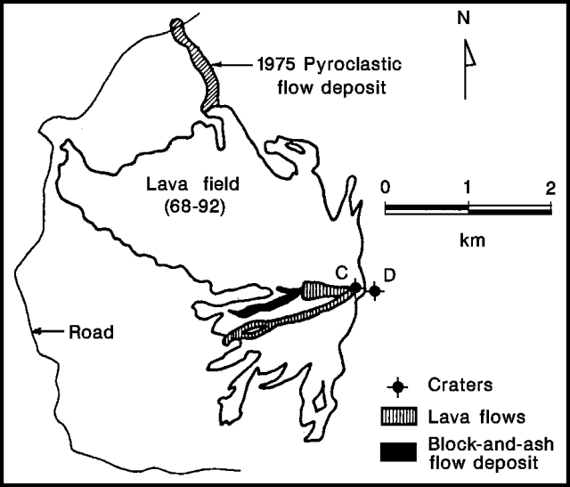 |
Figure 44. Map of late 1991-February 1992 lava flows and the 24 February block-and-ash flow at Arenal. Courtesy of ICE. |
Strombolian explosions were low in number and magnitude in February, with 173 recorded during the first 18 days. Many ash emissions, to 1 km height, were observed without obvious explosions. Size analysis of one tephra sample collected on 26 February showed that 85% was coarse-ash and <15% was very coarse ash to fine lapilli. The sample was composed primarily of vesiculated rock fragments, aphanitic and porphyritic in character, and plagioclase crystals.
An average of 10 volcanic earthquakes (a range of 2-24) was recorded daily (at ICE station "Fortuna" 4 km E of the crater) in February. Large increases in tremor period and energy were measured on 6, 7, and 21-25 February, coinciding with increased lava output and strong gas emission. Tremor was recorded up to 24 hours/day.
Information Contacts: E. Fernández, J. Barquero, V. Barboza, and R. Van der Laat, OVSCIORI; G. Soto and R. Barquero, ICE.
Lava flows continue to advance; Strombolian activity weakens
The two lava flows active in February continued to descend the W and WSW flanks in March (figures 45 and 46). The WSW-flank flow bifurcated, with one tongue advancing 50 m in early March to 730 m elevation, before stopping in mid-month. Near 1,100 m elevation, the W-flank flow also divided; one lobe advanced W down a valley, while the other diverged to the WSW, overflowing the September 1991-March 1992 flows (figure 46). The lava flow advanced an estimated 10-20 m daily on the upper slope, and 2-5 m daily on the gentler, lower slope. The most active, northern- and southern-most, lobes extended to 870 m and 830 m elevation, respectively, the first time in several years that lava had reached that elevation on the WSW flank.
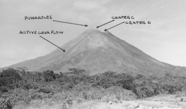 |
Figure 45. Photograph of Arenal by G. Soto, showing its summit craters and active lava flows, 16 March 1992. Courtesy of ICE. |
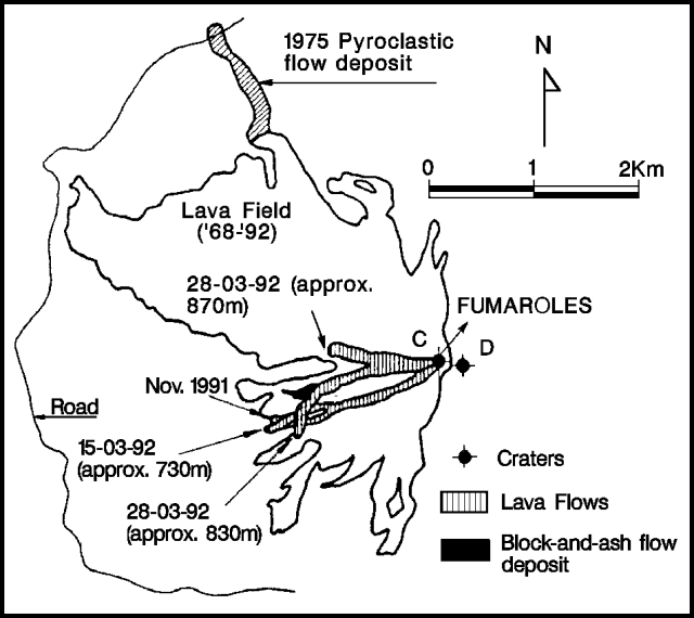 |
Figure 46. Map of late 1991-March 1992 lava flows at Arenal. Courtesy of ICE. |
Strombolian activity continued at a significantly decreased rate and intensity, consisting primarily of sudden or rhythmic degassing events, with little or no pyroclastic ejection. In addition to intense fumarolic activity in Crater C (the active crater), intense steaming was observed between craters C and D (300 m E of Crater C).
Seismic activity was at moderate levels, with an average of 15 earthquakes recorded daily (at station FOR, 4 km E), and peaks on 4, 25, and 30 March. Increases in tremor were recorded on 11, 13, and 18 March.
Information Contacts: G. Soto and R. Barquero, ICE; G. Alvarado, GEOMAR, Germany; M. Fernández, Univ de Costa Rica.
Continued block lava extrusion and Strombolian explosions; frequent tremor
Block lava extrusion from the summit area began soon after the start of the eruption in 1968. Since then, an extensive lava field has developed on the W side of the volcano. The northernmost lobe of the W-flank lava flow stopped growing in April. Its southernmost lobe, however, continued a slow advance to 775 m elevation, reaching the forest, and burning some 20,000 m2 of fields. Strombolian explosions continued, at intervals of several minutes to hours. During 12-22 April fieldwork by OVSICORI and SI scientists and volunteers, 539 seismic events were recorded. The majority of the signals were associated with gas and ash emissions with locomotive and jet-engine sounds (figure 47). Continuous tremor of low, medium, and high frequency, associated with lava extrusion, was recorded almost 24 hours/day during this period. Seismicity decreased moderately from previous months (recorded at the ICE station "Fortuna", 4 km E of the summit), with a maximum of 16 earthquakes/day (18 April), and an average of 6/day. High levels of continuous tremor were recorded on 9-15, 21, 23, 25, and 27-28 April.
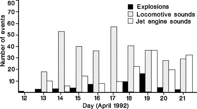 |
Figure 47. Seismicity at Arenal, 12-21 April 1992. The 21 April data only include 17 hours of measurements. Courtesy of OVSICORI. |
Information Contacts: E. Fernández, J. Barquero, and V. Barboza, OVSICORI; G. Soto and R. Barquero, ICE; W. Melson, SI.
Lava flows continue to advance; stronger and more frequent explosions
Two lobes of the lava flow active since November continued to extend down the W flank in May, with an estimated total volume of 3 x 10⁶ m3 of lava. The northernmost lobe divided into several fronts; the longest reached to ~800 m elevation, while the most active front became channeled in a valley at ~855 m elevation on 14 May. A lava temperature of 820°C was measured at the front using an infrared thermometer. The southern lobe continued to travel along a more gentle slope to ~700 m elevation, covering and burning roughly 100 m2 of forest and grasslands. Summit incandescence, visible at night, suggested to scientists that a lava lake was feeding the active lava flow. Small pyroclastic flows occurred sporadically. One observed at 0723 on 13 May flowed down the W flank to 1,200 m elevation.
Explosive activity increased in number and magnitude from preceding months, especially since 26 May, when new explosions produced ash columns >1 km high and bombs fell to 1,000 m elevation. Between 23 April and 12 May, 80 g/m2 ash had accumulated 1.8 km W of the crater (at 740 m elevation). Samples were composed of very fine ash (40%), and fine and medium-sized scoria fragments and plagioclase crystals (60%). Volcanic earthquakes averaged 10/day in May (compared to 6 and 15 daily in April and March, respectively), with maxima of 20-24 on 15, 23, and 28 May. The month's highest levels of tremor were recorded on 7, 12, 14, 17, and 22 May.
Information Contacts: G. Soto, R. Barquero, and G. Alvarado, ICE; M. Fernández, Univ de Costa Rica; E. Fernández, J. Barquero, and V. Barboza, OVSICORI.
Lava production and tephra ejection continue
Lava production, tephra ejection, and fumarolic activity continued through mid-July. Most of the W-flank lava moved down a channel feeding the flow's S lobe, which moved into young forest on the WSW flank, an area that had been affected by the 1968 pyroclastic flows. Since mid-May, the S lobe's front had advanced almost 300 m, reaching 665 m elevation on 10 June and 650 m elevation by the 24th. As it advanced, the lava flow continued to start fires that burned well over a hectare of the surrounding woodland. Between 12 and 22 July, the flow front advanced at an average rate of ~20 m/day, reaching ~2.5 km from the new summit crater (C). The lava supply to the N lobe had dwindled, and its front had halted at 830 m elevation.
Explosions were stronger and more numerous in June than in May. Some caused rumbling that vibrated house windows in La Palma, 4 km N of the volcano. An impact crater 1 m in diameter and 30 cm deep was found at 780 m elevation on the W flank, and large blocks frequently reached slightly >1 km from the new summit crater (C) 12-22 July. Some ash columns rose >1 km above Crater C. The rate of explosions varied; during observations on 12 June, an explosion was heard every hour. Ashfall on the observation point at 780 m elevation, 1.8 km W of the active crater, accumulated more rapidly in the 4 weeks ending 10 June than in the succeeding 2 weeks (see table 5). Vegetation on the NE, E, and SE flanks continues to be affected by acid rain and tephra fall, as it has for more than 20 years. Fumarolic activity occurred from the remnants of the old summit crater (D).
Volcanic seismicity recorded at a station (Fortuna) 4 km E of the active crater averaged 30 events/day, with a maximum of 51 on 18 June (figure 48). Conspicuous tremor episodes occurred on 4, 6, 10, 17, and 30 June. The level of both seismic and pyroclastic activity decreased 12-22 July, as did the number of avalanches from the advancing lava flow front.
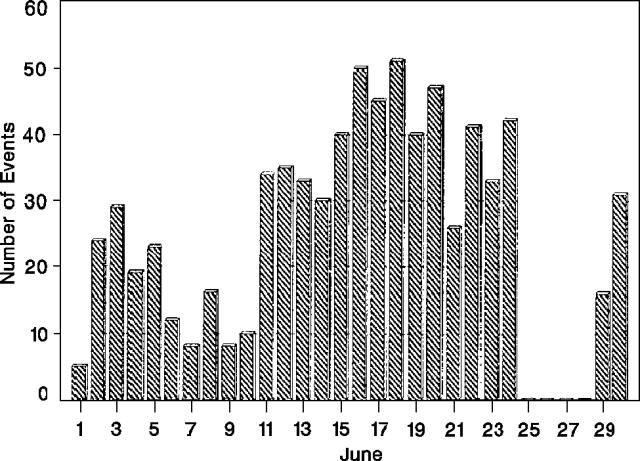 |
Figure 48. Daily number of seismic events recorded at a station (Fortuna) 4 km E of Arenal's active crater, June 1992. Courtesy of the Instituto Costarricense de Electricidad. |
Information Contacts: E. Fernández, J. Barquero, and V. Barboza, OVSICORI; G. Soto, ICE; M. Fernández, Univ de Costa Rica.
Lava extrusion; Strombolian activity; pyroclastic flows
Extrusion of block lava, sporadic Strombolian activity, and gas emission were continuing in early August. Small pyroclastic flows were occasionally generated, as on 4 August at 1543 when one moved W and another S, and the ash column rose more than 1 km above the active summit crater (C). Another pyroclastic flow traveled S at 1604, reaching 1,050 m elevation. Lava continued to flow SW into the forest, advancing 150 m over a 15-day period ending in early August to reach 640 m elevation. Fumarolic activity occurred from the old summit crater (D).
On 12-22 July, personnel from OVSICORI, W. Melson, and a group of SI volunteers carried out 24-hour monitoring of the volcano. They sonically recorded 679 eruption events of three types (figure 49). Some were detected seismically 30 km away (at OVSICORI station JTS). Harmonic and monochromatic tremor were recorded for several-minute periods.
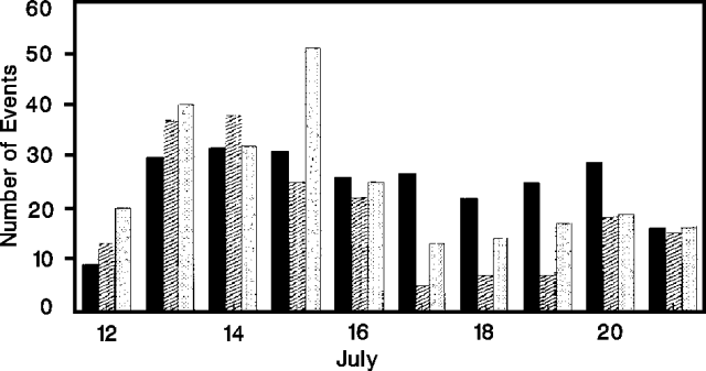 |
Figure 49. Number of sonically recorded eruptive episodes at Arenal, 12-21 July 1992. Black bars represent explosions; diagonally shaded bars, brief pulses of Strombolian activity; and stippled bars, more continuous Strombolian activity. Data were collected for 6 hours on 12 July and for 13 hours on 21 July. Courtesy of the Univ Nacional. |
Vegetation on the NE, E, and SE flanks continued to be affected by acid rain and tephra fall. Small cold avalanches occurred in the Calle de Arena and Guillermina quebradas, and the Río Agua Caliente.
Information Contacts: E. Fernández, J. Barquero, and V. Barboza, OVSICORI.
Lava extrusion and explosive activity; small pyroclastic flows
Lava extrusion, explosive activity, and gas emission were continuing in early September. The block-lava flow that has been descending the WSW flank reached 615 m elevation, entering an area of forest and grassland along a front 6-15 m high and 100 m wide. A small area of vegetation was burned. The active lobe was subdivided into two tongues; the southern tongue was advancing at the end of August. By early September, however, its rate of advance was very slow, and a new flow had begun to descend toward the SW, with an active front at 850 m elevation.
Strombolian explosions were infrequent in August; gradual to sudden degassing events were more common. Characteristics of ash collected on the W flank are shown in table 5. Small pyroclastic flows were occasionally generated. Fumarolic activity continued from the old summit crater (D). Acid rain with a mean pH of 4.3 was still affecting vegetation on the W and SW flanks.
Volcanic seismicity generally remained similar to June and July, with an average of 25 events/day and maxima of 30-40 daily (figure 50). Periods of intermittent tremor occurred mainly on 5-7, 11, 14, 17, and 21-22 August.
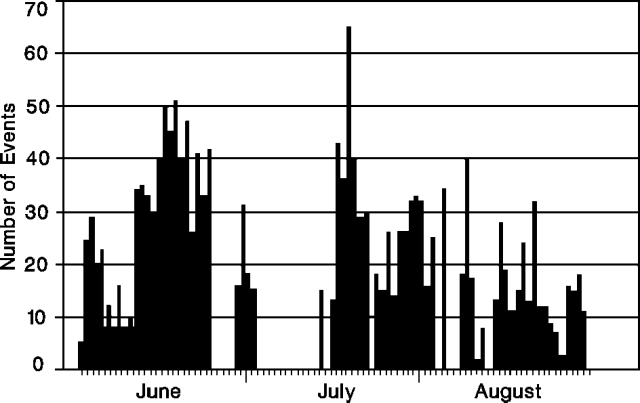 |
Figure 50. Number of seismic events recorded (by station FOR) 4 km E of Arenal's active crater, June-August, 1992. Courtesy of ICE. |
Information Contacts: G. Soto and R. Barquero, ICE; E. Fernández, J. Barquero, and V. Barboza, OVSICORI.
Lava production and Strombolian activity continue
Lava production, explosive tephra ejection, and gas emission continued from the summit area. The lava flow that had been advancing down the WSW flank stopped at 615 m elevation around the end of August and the beginning of September. Advance of the front appeared to have halted because of an interruption of the flow at ~1,100 m elevation, where overflows of block lava occurred from both sides of the lava channel. A flow that had begun to emerge in mid-August continued its advance toward the SW, reaching 720 m elevation and covering a grassy area. Overflows from the central part of this flow produced small avalanches. Strombolian explosions remained sporadic, but became more vigorous after 28 September, sometimes rattling windows in La Fortuna, ~6.5 km NE of the summit, and at an ICE facility in Sangregado, 7 km to the NW. Ash columns rose >1 km from Crater C, dropping ash on the flanks (see table 5), and blocks and bombs fell to 1,000 m elevation. Occasional pyroclastic flows were generated, extending to elevations of 1,300 m on the NE flank and 1,200 m on the N and S flanks. Vigorous fumarolic activity continued in the summit area. Little change was detected in volcanic seismicity, with an average of 25 events/day, peaking at 55 on 29 September.
Information Contacts: G. Soto and R. Barquero, ICE; E. Fernández, J. Barquero, and V. Barboza, OVSICORI.
Strong Strombolian explosions; lava and pyroclastic flows
Lava production, explosive activity, and gas emission continued from Crater C. The lava flow that had been descending the E and ESE flanks since mid-January has stopped, with its front at 610 m elevation. The lava channel remained obstructed near 1,100 m elevation. Levees had been pushed away and broken on both sides of the channel. Residents of the area reported that some of the resulting block overflows caused small pyroclastic flows that reached ~800 m elevation, producing ash columns several hundred meters high. At the beginning of October, a new lava flow began to descend to the SW, using the same channel to 1,200 m elevation, where it bifurcated. One lobe (to the W) reached 950 m elevation, the other (to the SW) extended to 1,000 m elevation. The lava flow that had been moving SW in September, covering a grassy area, stopped at 700 m elevation.
Intermittent Strombolian eruptions continued, some producing ash columns that rose more than a kilometer above Crater C. Activity was vigorous during the first half of the month, when ashfall on a fixed sampling point 1.8 km W of the active crater (at 735 m elevation) was at the highest rate of the year (see table 5). Blocks and bombs fell to 1,000 m elevation. The explosions vibrated windows in [La Fortuna]. Pyroclastic flows were occasionally generated, and probably produced the pyroclastic-flow deposits found on the W, SW, and S flanks.
Seismicity recorded at a station (Fortuna) 4 km E of the active crater showed a moderate increase during the first 2 weeks of the month, coinciding with the vigorous explosive activity. The 80 events recorded on 9 October were the most on a single day in 1992. Fewer earthquakes occurred during the second half of October, with a mean of 25 events daily and a maximum of 46 (on the 31st). High-energy tremor accompanied the increased activity, especially during the first and third weeks of the month.
Floods during the intense rainy period in September and October caused some small erosive changes in the depositional fans of the Chato and Calle de Arena rivers (E of the volcano), carried sand into Laguna Cedeño (N side), and deposited sand and blocks in the Agua Caliente river (to the SW).
Species repopulating the lava flows and the devastated area continued to be affected by acid rain. Some plants had burns on their edges and tips, and others had discolored leaves.
Two persons were injured on the W flank during the last week in September while making separate ascents to the summit. The first was a local guide, overtaken by a landslide of unstable material near Crater D, who received head injuries that required several days of hospitalization. The second was an English tourist, who suffered a fractured tibia and fibula when he fell into a canyon after the collapse of the wall on which he was walking.
Information Contacts: G. Soto and R. Barquero, ICE; E. Fernández, J. Barquero, and V. Barboza, OVSICORI.
Lava flows, Strombolian activity, and gas emission
Lava production, intermittent Strombolian activity, and gas emission continued from the active summit-area crater (C). Activity continues to build a lava delta on the WSW slope. The most recent flow continued to advance through pre-existing channels, reaching 855 m elevation on 5 December, near the terminus observed in May. The flow was ~200 m wide and 10 m thick. Temperatures of the crust at the flow front reached 480°C, but the red interior exceeded 800°C. Blocks overflowed levees on both sides of the other lobe's channel, where it was obstructed at ~1,100 m elevation. Occasional pyroclastic flows left deposits on the W and SW flanks.
Ash ejected by the Strombolian activity occasionally rose >1 km above the crater and was carried by winds onto the NW, W, and SW flanks (table 5). Blocks and bombs fell on the upper flanks, to 1,000 m elevation. As usual, the more intense explosions vibrated windows of houses in La Fortuna, 6.5 km E. Between 14 and 22 November, the rate of audible pyroclastic activity monitored from the Arenal Observatory lodge . . . averaged 120 events/day (figure 51).
Table 5. Deposition rates, volume, and size distributions of ash collected 1.8 km W of Arenal's active crater, at 735 m elevation, 23 April-5 December, 1992. Courtesy of ICE.
| Dates | g/m2 | (g/m2)/day | Medium to very coarse ash | Fine ash to dust |
| 23 Apr-12 May 1992 | -- | 4.3 | 0 | 100% |
| 12 May-10 Jun 1992 | 538 | 20.1 | 34.7% | 65.3% |
| 10 Jun-24 Jun 1992 | 174 | 12.4 | 46.4% | 53.6% |
| 24 Jun-19 Jul 1992 | 457 | 17.6 | 51.8% | 48.2% |
| 19 Jul-25 Aug 1992 | 559 | 15.1 | 46.7% | 53.3% |
| 25 Aug-09 Sep 1992 | 106 | 7.1 | 37.0% | 63.0% |
| 09 Sep-23 Sep 1992 | 183 | 13.1 | 33.3% | 66.7% |
| 23 Sep-14 Oct 1992 | -- | 36.2 | 49.3% | 50.7% |
| 14 Oct-05 Nov 1992 | -- | 33.7 | 55.1% | 44.9% |
| 05 Nov-05 Dec 1992 | -- | 14.6 | 51.1% | 48.9% |
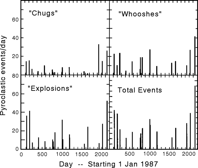 |
Figure 51. Average daily number of pyroclastic events at Arenal, during 16 approximately 10-day periods, 1987-92. Event types are characterized by sound: "whooshes" are intense gas, block, and bomb fountains; "chugs" are rhythmic, less intense gas emissions, commonly accompanied by blocks and bombs. Observations were made from Arenal Observatory lodge (2.8 km S of the summit) by Earthwatch and Smithsonian Volunteer Expeditions personnel. Courtesy of W. Melson. |
Summit fumarolic activity remained vigorous, and gases were carried W by the trade winds. Vegetation on the NW, W, and SW flanks continued to be affected by acid rain, and falling blocks and bombs, as it has over the past 24 years. Steep slopes and high rainfall continued to trigger small cold avalanches in flank canyons (quebradas Guillermina and Calle de Arenas, and the río Agua Caliente).
In November, seismic activity averaged 25 events/day, with a maximum of 51 (on the 9th). Tremor activity had also declined somewhat.
Information Contacts: G. Soto and R. Barquero, ICE; E. Fernández and J. Barquero, OVSICORI; W. Melson, SI.
Lava flows; sporadic Strombolian activity; gas emission
Strombolian activity, gas emission, and extrusion of lava flows persisted through December from Crater C. Fumarolic activity continued from Crater D. Both lobes of the November lava flow had stopped advancing, the SW lobe at 800 m elevation, covering a small grassy area, and the W lobe at 850 m. A new flow began to descend toward the SW in December, using the same channel. It divided at 1,100 m elevation, with one lobe moving more toward the S, to 1,000 m elevation, the other more toward the W to 1,050 m elevation. Lava overflows fed small avalanches.
Sporadic Strombolian activity ejected bombs, blocks, and ash. Impact craters 1.5 m in diameter and 40 cm deep were found on the W flank above 800 m elevation. Ash columns rose >1 km. Some of the explosions vibrated windows 4 km N of the volcano (in La Palma).
Plants colonizing the lava flows and the devastated zone continued to be affected by acid rain (pH 3.8-4.4) and ashfall. Some had burns on the tips and edges of their leaves, and the colors of others had faded.
Information Contacts: E. Fernández and J. Barquero, OVSICORI.
Lava flows continue; Strombolian activity decreases; deflation
The lava flow that began to descend SW from Crater C in December remained active. The W lobe had reached 840 m elevation, the S lobe 820 m, covering a grassy area. Lava overflows continued to feed small avalanches. Strombolian explosions from Crater C were weaker and less frequent in January than in December. Fumarolic activity continued from Crater D.
Deflation has continued since deformation measurements began in 1982. The deflation is more evident on dry tilt stations nearest the active crater (at 1.8-3 km distance). Small-scale inflation averaging 9 µrads occurred between measurements in October and December 1992 on stations SW, W, NW, and NE of the summit. Although horizontal distance measurements generally contracted between November 1991 and January 1993, two of five distances expanded ~15 ppm between October and December 1992, coinciding with inflation detected by dry-tilt measurements. Geologists noted that these changes could have been influenced more by lava flows near the reflectors than by magma movements at depth.
Information Contacts: E. Fernández, J. Barquero, R. Van der Laat, F. de Obadía, T. Marino, and R. Sáenz, OVSICORI; M. Martini, Univ di Firenze, Italy.
Gas emission, explosions, lava flows continue; tremor activity increases
Gas emission, explosions, and lava flows continued from Crater C. Strombolian activity was similar to last month, with relatively quiet explosions of moderate size that produced columns, with minor ash content, to 500-1,000 m above Crater C. Ash fell 1.8 km W of the active crater down to 735 m elevation. Sudden small-moderate degassing events, separated by a few to tens of minutes, were accompanied by frequent loud sounds. A pyroclastic flow in mid-February moved down the S flank to 850 m elevation.
The lava flow that began to descend in December 1992 remained active after dividing into two lobes at 1,100 m elevation. The W lobe, with an approximate thickness of 18 m, descended to 800 m elevation in February. During the same period, the SE lobe descended from a flat area just above 800 m down to 700 m elevation.
Tremor activity recorded at Fortuna station, 3.5 km E of the active crater, has increased since the end of January. The increase is thought to be associated with the rise of new magma to the surface. The number of seismic events (average of 36/day; figure 52), was similar to last month and in the normal range. However, there was an increase in the number of seismic events after each tremor episode.
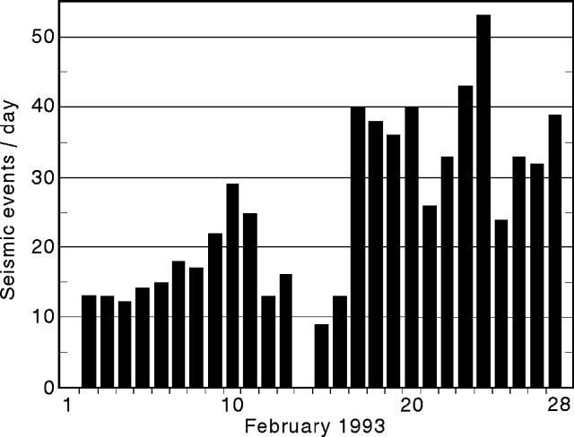 |
Figure 52. Number of seismic events/day at Arenal (Fortuna station), February 1993. Courtesy of G. Soto and R. Barquero. |
Sulfur and chlorine gas emissions from fumaroles on the rim of Crater C continued to produce acid rain that has damaged vegetation on the NE, E, and SE flanks. Fumarolic activity continued from Crater D.
Information Contacts: G. Soto and R. Barquero, ICE; E. Fernández and J. Barquero, OVSICORI.
Strombolian activity increases; new lava flow
Gas emission and lava flows continued from Crater C. Both the number and magnitude of Strombolian eruptions increased from January and February levels. Some eruptions caused vibration of windows at the Macadamia Biological Observatory (2.7 km S) and ballistic bombs reached the 1,000-m elevation on the flanks.
The more-SW lava flow that was active last month advanced over a grassy field and stopped at 760 m elevation. A new flow descended SW, following the same route as the December 1992 flow. At 1,350 m elevation it divided; one lobe went W, reaching 1,100 m elevation, while the other traveled SW to 1,200 m elevation. Another lava flow moved down the SSW flank to 1,450 m elevation. At 0920 on 31 March, gravitational failure of this flow produced numerous small avalanches falling to 750-850 m elevation. On 23 March at 1930 a pyroclastic flow descended SE to 1,100 m elevation.
Seismic activity remained normal. An average of 40 earthquakes/day were recorded by ICE (figure 53), a slight increase from last month. A seismometer operated by UNA, 2.7 km NE of the main crater, registered a total of 465 explosions and 226.5 hours of tremor during 13-31 March (figure 54. The dominant frequencies of these events were 1.5-2.3 Hz. During 28-30 March the tremor increased, becoming continuous for a 24-hour period. The highest daily total of explosions for the month occurred on 16 March, the fewest on 30 March. Fumaroles near the summit continued to emit sulfur gases and water vapor. Explosions were accompanied by decreased gas emission.
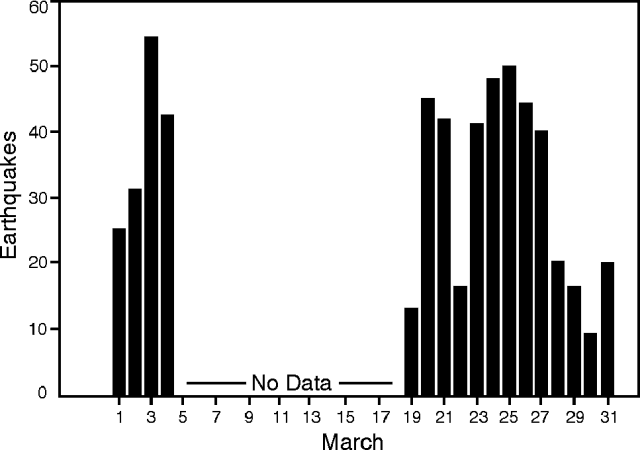 |
Figure 53. Earthquakes/day recorded at Arenal during March 1993. Courtesy of ICE. |
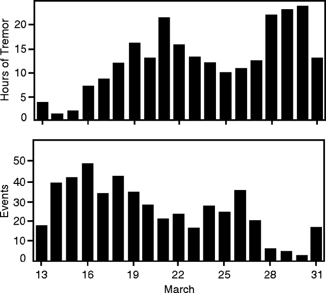 |
Figure 54. Hours of tremor/day (top) and events/day (bottom) recorded 2.7 km NE of the summit of Arenal during 13-31 March 1993. Courtesy of OVSICORI. |
The slight inflationary trend seen at most of the dry-tilt stations stopped. Occasional slight deflation occurred at dry-tilt sites Ferreto (3 km SW of summit) and Cedeño (4 km NW of summit). EDM lines on the S and W contracted in March.
Information Contacts: G. Soto and R. Barquero, ICE; E. Fernández, J. Barquero, V. Barboza, T. Marino, R. Van Der Laat, F. de Obaldía, and R. Sáenz, OVSICORI.
Explosions decrease as lava production increases
Gas emissions and lava flows continued from Crater C in April, and Strombolian activity vibrated windows of houses in La Palma, ~4 km N. Ash-laden columns were blown E on 15 April, and sporadic pyroclastic flows were observed. The character of the eruption changed on 20 April as the number of explosions decreased while degassing and effusion of lava increased.
The lava flow that started down the SW flank in March remained active. Its W lobe reached 1,050 m elevation and its SW lobe reached 1,000 m elevation. The flow descending the S flank halted at 1,400 m elevation. About the middle of the month a new flow began to descend the SW flank.
A seismograph ~2.7 km NE of the active crater recorded 1,314 explosions in April, an average of 44 explosions/day (figure 55, bottom). The highest daily total was 84 on April 21, and the lowest was 13 on 27 April. Some of the explosions were recorded by a new seismograph network 120 km distant. Tremor was most persistent on 7, 19 and 20 April with 19, 19, and 21 hours recorded respectively (figure 55, top). The tremor frequency was between 1.3 and 2.3 Hz.
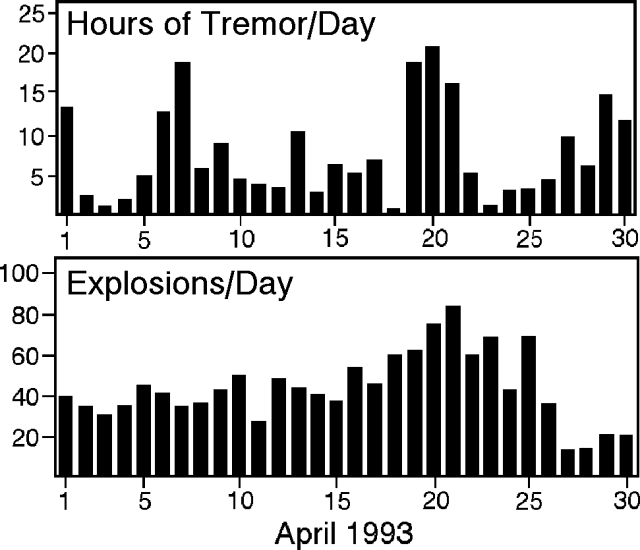 |
Figure 55. Hours of tremor/day (top) and explosions/day (bottom) recorded 2.7 km NE of Arenal. Courtesy of OVSICORI. |
Activity 18-27 April was reported by W. Melson. "Arenal volcano was in continuous eruption. Loud explosions were common 18-19 April, but by 21 April were replaced by frequent chugging and whooshing sounds (figure 56) from summit scoria fountains. These fountains fed a slowly descending, viscous, blocky, highly phyric hypersthene-augite basaltic andesite flow, which spilled over the WSW side of the crater. The flow's advance was accompanied by spectacular avalanches of incandescent blocks from the flow front."
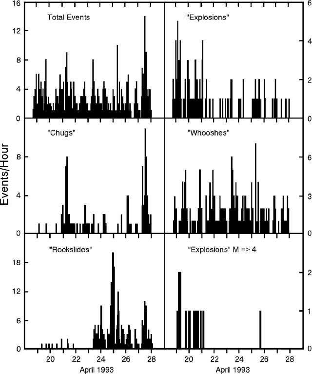 |
Figure 56. Activity of Arenal, 18-27 April, as observed from Arenal Volcano Lodge, 2.8 km S of the summit craters. "Chug" and "whoosh" events are characterized by their sound. Courtesy of W. Melson. |
Information Contacts: E. Fernández, J. Barquero, V. Barboza, and W. Jimenez, OVSICORI; W. Melson, SI; S. McNutt, AVO.
More lava; ash explosions decrease
Activity continued at Crater C in April and May with gas emission and lava flows. Several areas near the summit and within the crater contained active fumaroles. Fumarolic activity was also present in Crater D. Explosive activity from Crater C was continuing, but has declined since early in the year. An average of 7.2 g/m2/day of ash was collected by ICE geologists between 30 March and 5 May at a point 1.8 km W of the active crater. During January and February of this year, an average of 18.5 g/m2/day was collected.
Sporadic ash eruptions reached 600 m above the crater rim. Ballistic bombs and blocks fell to 1,100 m elevation. The SW-flank lava flow that started from Crater C in March remained active in May, with the W lobe stopping at 1,000 m, 50 m below the April terminus. The W lobe of the SW-flank lava flow that began in mid-April stopped at 1,200 m elevation, while the SW lobe reached 1,250 m. The flow that was descending SSW in March and April, reaching 1,400 m elevation, is no longer active. Small avalanches or pyroclastic flows are occasionally generated from the lava flow fronts. A new lava flow began traveling W in early May and reached 1,400 m. One lobe, to the WNW, continued to almost 1,200 m elevation and generated frequent block collapses, which have filled the valley between it and the October 1991 to March 1992 lava flows. Three Merapi-type pyroclastic flows were observed moving WSW at 1235 on 12 May. Ash clouds from these pyroclastic flows reached 300-500 m height.
Deformation measured at dry-tilt stations between 2 March and 15 April was less than the survey error limits. Slight inflation was detected at the NW dry-tilt stations during this period, and the radial distance to the crater increased 23 ppm SW and 12 ppm S. The seismic station 2.7 km NE of the active crater (VACR, operated by OVSICORI) recorded 496 explosions, most associated with gas and vapor emission (figure 57, top). This is a significant decrease from April, when 1,314 explosions were recorded . . . . The highest daily number of seismically detected explosions (34) occurred on 10 May. A similar decrease in seismicity since April was evident at a seismic station 3.5 km E of the active crater (Fortuna, operated by ICE). This station recorded an average of 30 volcanic seismic events/day in April, decreasing to an average of 10 events/day in May (figure 58). Several small tectonic events, an average of 3/day, were also detected, with epicenters <=25 km from the volcano. Middle- and low-frequency tremor was recorded at the VACR station for 123 hours in May (figure 57, bottom); frequencies were <3 Hz.
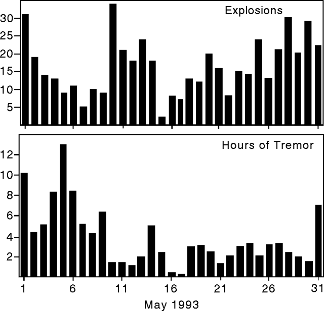 |
Figure 57. Daily totals of seismically detected explosions (top) and hours of tremor (bottom) recorded 2.7 km NE of the active crater at Arenal, May 1993. Courtesy of OVSICORI. |
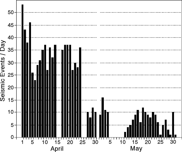 |
Figure 58. Daily totals of volcanic seismic events recorded 3.5 km E of the active crater at Arenal, April-May 1993. Gaps in data are a result of equipment failure. Courtesy of Gerardo Soto, ICE. |
Information Contacts: E. Fernández, J. Barquero, F. De Obaldía, T. Marino, R. Van Der Laat, V. Barboza, and R. Saenz, OVSICORI; G. Soto, ICE.
Pyroclastic flows; lava flows remain active
Lava flows that began earlier this year remained active, and gas emissions continued from Crater C in June. Sporadic Strombolian activity sent ash columns >500 m above the crater rim; some ash fell up to 1 km away. Ash was carried by the wind to the NW, W, and SW. Ballistic bombs and blocks fell to 1,100 m elevation. Several pyroclastic flows produced by lava-front collapses have been seen. The largest observed pyroclastic flow, at 1434 on 24 June, produced an ash cloud about 1 km high and traveled about 750 m while descending from 1,400 to 1,000 m elevation on the SW flank. Based on morphological changes of the cone, other rockslides are believed to have occurred high on the NW flank at ~1,300 m elevation. The lava flow on the SW flank that began in March has stopped with both the W and SW lobes at ~1,000 m elevation. The W flank lava flow that began in May descended to 1,000 m elevation. The lava flow that started in mid-April on the SW flank remained active as its W lobe reached 1,200 m elevation and its SW lobe descended to 1,250 m. Summit fumaroles also remained active.
The seismic station 2.7 km NE of the active crater (VACR, operated by OVSICORI) recorded 790 seismic events (1.4-3.0 Hz), an average of 26 events/day. The highest daily totals were 65 events on 16 June and 64 on 22 June. Most of the seismicity was associated with explosive gas emissions that sounded like jet engines or trains. The VACR station also registered >195 hours of tremor with frequencies of 1.3-2.8 Hz. The highest daily totals were on 24-26 June, when >57 hours of tremor were recorded. ICE geologists saw or heard an average of 10 explosions/day in late June. Tremor was recorded for several hours/day in June by portable seismometers operated by ICE.
Information Contacts: E. Fernández, J. Barquero, and V. Barboza, OVSICORI; G. Soto, ICE.
Lava flows remain active; explosions and pyroclastic-flow activity decrease
Gas emissions and lava flows continued at Crater C in July, as well as sporadic Strombolian activity that sent ash columns >500 m above the crater rim. Explosions have decreased in quantity and magnitude compared to June. The lava flow that started in mid-April on the SW flank remained active as its W lobe descended another 50 m to 1,150 m elevation and the SW lobe traveled 150 m down to 1,100 m. A new lobe from this flow that formed in early July descended to the SW. A new lava flow was also observed on 20 July moving WNW. At 1022 on 21 July a rock avalanche traveled NW to 1,300 m elevation. Another avalanche was observed later that day at 1100, and seven more occurred from 1314 and 1355. The lowest elevation reached by the fronts of these nine avalanches was 1,150 m.
Three distance lines continued to show minor contraction in 1993. The last measurement was made on 21 July. The radial leveling line on the W flank indicated deflation of 8.9 µrad between 26 August 1992 and 21 July 1993. Deformation measured at most dry-tilt stations was insignificant. However, three stations on the SW and W flanks exhibited cumulative inflation of ~10 µrad since 15 April. The seismic station 2.7 km NE of the active crater (VACR) registered 651 events in July, with the highest daily total on 21 July. Most of the seismicity was associated with ash eruptions and pyroclastic activity. The level of explosive activity was less in June and July than earlier in the year. Tremor averaged 13 hours/day, with the highest daily total of 23 hours recorded on 8 July. There was more tremor in July than in any previous month this year.
The following report, of activity from 25 July to 4 August, is from W. Melson (SI), and V. Barboza and Jorge Barquero (OVSICORI). "Arenal showed an extremely low level of pyroclastic activity during this period, the lowest recorded during regular periods of observations by Smithsonian Institution volunteers since 1987. There have been 18 such observation periods, each lasting about 10 days for 24-hours/day, from the Arenal Observatory Lodge about 2.8 km S of the summit (figure 59). Periods of high tremor were common. Ongoing 3-component seismic measurements have shown that tremor produces weak vertical signals but strong horizontal signals (figure 60). The dominance of horizontal over vertical motion has been characteristic of Arenal's seismicity over the past 3 years. Local observers reported that a large fragment of the WNW rim collapsed around 19 or 20 July, forming a notch through which lava continued to move as of 4 August. The lava flow was moving slowly (~10-30 m/day) down the WNW slope, and had reached ~1,100 m elevation below the new cone being built to an approximate elevation of 1,650 m above old Crater C."
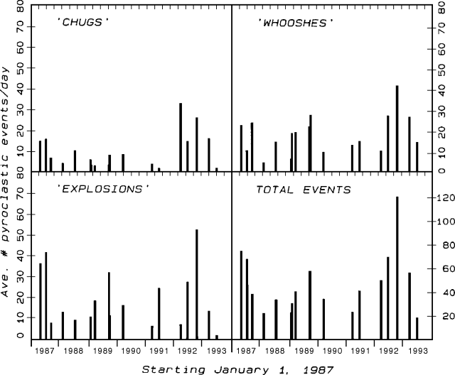 |
Figure 59. Summary of pyroclastic-flow activity at Arenal since 1987 during 18 approximately 10-day periods of 24-hours/day observations from the Arenal Observatory Lodge, 2.8 km S of the summit, made by Earthwatch and Smithsonian Institution volunteer expeditions. "Chug" and "whoosh" events are characterized by their sound. Courtesy of W. Melson. |
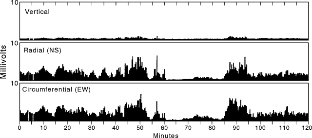 |
Figure 60. Tremor levels at Arenal during a 2-hour period on 25 July 1993. Values are averaged over 21.5-second intervals and calculated as equal to the sum of the absolute values of signals in decimillivolts divided by number of counts/21.5 seconds at an AD conversion rate of about 100 counts/second. A Mark L-4C 3D seismometer was used with a 16 bit AD board. Courtesy of W. Melson. |
Information Contacts: E. Fernández, J. Barquero, R. Van der Laat, F. de Obaldia, T. Marino, V. Barboza, and R. Sáenz, OVSICORI; W. Melson, SI.
Large pyroclastic flow down W flank; lava flows
New lava flows in late August were accompanied by one or more pyroclastic flows and a minor ashfall containing accretionary lapilli. On 28 August scientists at OVSICORI reported an active lava flow, followed by multiple pyroclastic flows at 2005-2044. Figure 61 documents the path of the new lava flow, the paths of possible multiple pyroclastic flows, the zone of disrupted vegetation (including many tree limbs broken by the weight of airfall ash), and the outer limits of airfall ash. Earlier in August, repeated lava eruptions, fumarolic activity, and occasional tephra emissions issued from crater C in a pattern well established over the past several years.
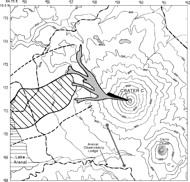 |
Figure 61. Map of Arenal depicting eruptive products from the 28 August activity. Universal Transverse Mercator (UTM) ticks on the map edges are 1 km apart. Map symbols include elevation contours (in meters), roads (dashed lines), lakes (horizontal slashed pattern), and the approximate location of the sub-radial distance line discussed in text (double lines terminated with circled squares). The symbols for eruptive products include the new lava flow (solid black), pyroclastic flow paths (shaded), the area where airfall ash damaged vegetation (oblique slashed pattern), and the margins of the airfall ash deposit (thick dashed lines). Courtesy of OVSICORI. |
The number of seismic events per month increased from January to April, but dropped to about half the April peak in May, and was roughly constant through August (figure 62, top). Thus, the number of seismic events per month has not been diagnostic of Arenal's recent, more explosive phase. In contrast, the number of hours of tremor/day (figure 62, bottom) clearly increased from May to August; it reached nearly continuous levels (23 hours/day) for 18-22 August, and remained comparatively high until the 28 August eruption (figure 63).
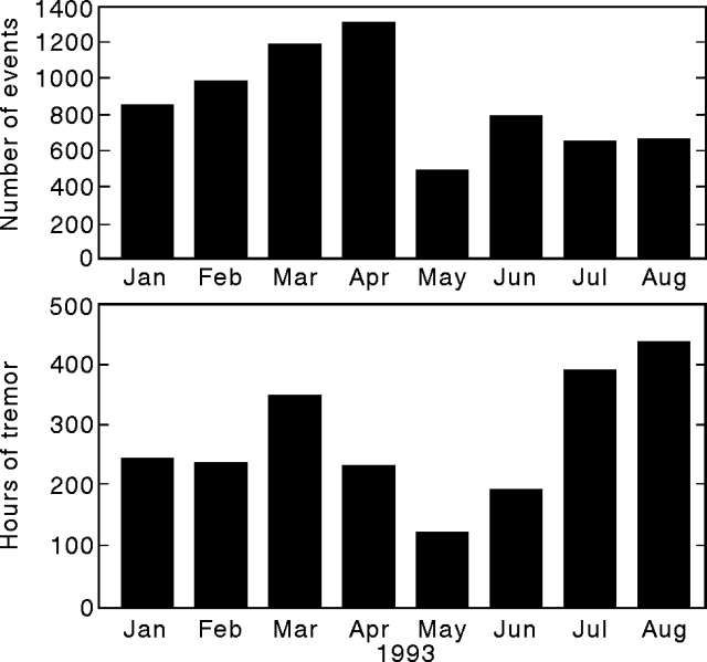 |
Figure 62. Seismicity for 1993 at Arenal showing monthly totals for number of events (top) and hours of tremor (bottom). Courtesy of OVSICORI. |
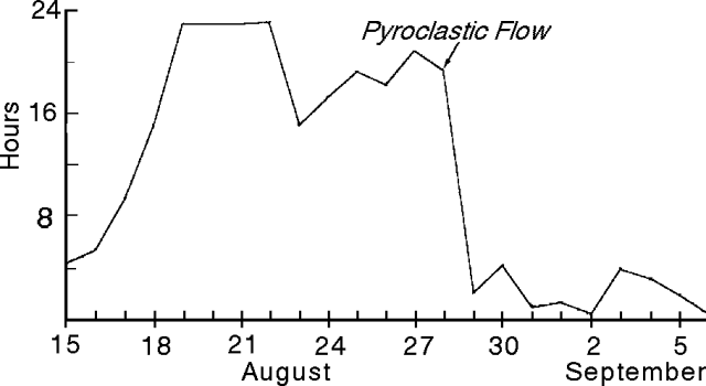 |
Figure 63. Hours of daily tremor at Arenal, 15 August to 6 September 1993. Courtesy of OVSICORI. |
Dry-tilt measurements made from October 1992 to 21 July 1993 on the W flank of the volcano showed inflation of 15 µrad. Horizontal strain computed from surveyed distance measurements on a SW sub-radial line (figure 61) for 1992-1993 generally indicated weak to moderate contraction. The last reported measurement, 24 August, was atypical because it indicated a length contraction of 116 ± 3 ppm, >4x as large as any reported in the last year.
On 27 August, seismic signals were of intermediate frequency, 6.5 mm amplitude and consistently of 118 seconds duration. Scientists at OVSICORI noted that these characteristic signals were repeated, and were possibly due to a series of small pyroclastic flows thought to have been generated by the partial collapse of active lava flows and a spatter cone constructed by Strombolian activity in the past few years. One or more larger pyroclastic flows were generated the next day (see figure 61).
Scientists at ICE reported that from about 2000-2040 on 28 August, several rockslides issued from the WNW face of the crater C cone; these loosened ~7 x 10⁵ m3 of material and were seismically registered 3.5 km E of the summit at the La Fortuna station (figure 64). At 2030, lava erupted from crater C and flowed NW. Then, from 2102-2105, ash discharged and flowed downslope. The resulting pyroclastic flow divided into multiple lobes. Associated with the pyroclastic flow, an ash cloud rose several kilometers. Deposits from the ash cloud consist of fine ash and accretionary lapilli, the latter presumably caused by mixing of ash with water droplets above the weather-cloud deck (see figure 64). The airfall deposit was distributed to the W of Arenal: 25-40 mm thick at 3 km, 0.5 mm thick at 13.5 km, and detected, but of unspecified thickness, at 30 km. After the ash discharge a blocky lava flow issued from the new crater opening. The lava advanced at an initial rate of 1,000 m/day on the first day, and at ~100 m/day on subsequent days.
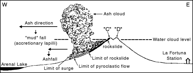 |
Figure 64. Diagrammatic illustration of Arenal's 28 August eruption (not to scale). Courtesy of ICE. |
Although the recent eruption caused no injuries, ashfall led to respiratory problems among some inhabitants of the region.
Information Contacts: E. Fernández, J. Barquero, R. Van der Laat, F. de Obaldia, T. Marino, V. Barboza, and R. Sáenz, OVSICORI; G. Soto, ICE.
Lava flow advances while overall level of eruptive activity declines
After the moderately explosive behavior seen on 28 August, the intensity of explosive activity at Arenal decreased in September. Lava flowing from crater C advanced farther to the NW, following the same drainages as the 28 August pyroclastic flows. By the end of September, lava in the Tabacón River valley had descended to 780 m elevation (see map in 18:08). In early September the rate of lava advance was about 50 m/day, slowing to ~20-25 m/day later in the month when flow fronts were ~1.5 km from the crater.
According to José Luis Sibaja, who lives on the E flank of the volcano, several degassing events in mid-September sent columns >1 km above the vent. Also, passive degassing was reported from crater D. On 15 September, due to atmospheric disturbances associated with a tropical storm, wind directions shifted and gases were swept toward the N and NE flanks, affecting forest vegetation.
The following discussion of seismicity is based on reports by OVSICORI. Total seismicity (number of events) in September was slightly higher than in May, July, or August. In contrast, the total hours of tremor for September decreased >3x compared to the previous two months, and is the lowest monthly level so far this year. Daily tremor chiefly remained below 4 hours/day from 1 to 27 September, then progressively increased to >20 hours/day on 30 September. The high total seismicity for September may be a result of abundant rockfalls and avalanches, some of which were visually documented. Rockfall and avalanche noise varies at different seismic stations, partly depending on the distance from the station to the noise source. The variable amount of noise contamination complicates simple comparison of seismic data collected by different research groups monitoring the volcano.
Information Contacts: E. Fernández, J. Barquero, R. Van der Laat, F. de Obaldia, T. Marino, V. Barboza, and R. Sáenz, OVSICORI; G. Soto, ICE.
Lava flows advance
October marked the second consecutive month of relative quiet at Arenal. The moderately explosive behavior seen on 28 August at the active vent, Crater C, decreased through both September and October. Fumarolic activity persisted at Crater D.
Lava flowing from crater C down drainages on the W slope of Arenal continued to advance. Scientists at OVSICORI reported that lava advanced in the Tabacón river valley (NW of the summit), and by the end of August reached 700 m elevation. They also reported that seismicity ranged from roughly 500 to 800 events/month for May through October 1993, whereas for January through May 1993, seismicity ranged from 550 to 1,300 events/month.
In the last ten days of October the daily number of earthquakes suddenly dropped. For the first 20 days of October 14-48 events/day were registered. In comparison, for the majority of the last 11 days of October <=10 events/day were registered. Thus far in 1993 continuous tremor averaged 264 hours/month; a low in continuous tremor occurred in September (109 hours), and it was above average in October (299 hours). Arenal's weakly explosive behavior was confirmed by scientists at ICE. Their seismometer, located 1.5 km from crater C (1.2 km closer to the crater than the OVSICORI seismometer), detected similar, though not identical, patterns of low seismicity and tremor.
Information Contacts: E. Fernández, J. Barquero, R. Van der Laat, F. de Obaldia, T. Marino, V. Barboza, and R. Sáenz, OVSICORI; G. Soto, ICE.
Relatively few explosions, high tremor and continued lava emissions
At Arenal hundreds to thousands of "seismic events" happen each month. The bulk of these events are thought to be caused by explosions associated with pyroclastic activity. In November the OVSICORI seismometer registered 203 seismic events (figure 65), the lowest total for any month thus far in 1993. For comparison, earlier in 1993 the same seismometer registered 2-7 times more events. In accord with the low number of seismic events, no one reported explosions or pyroclastic activity, although some minor pyroclastic flow deposits were recognized in the SW quadrant of the volcano.
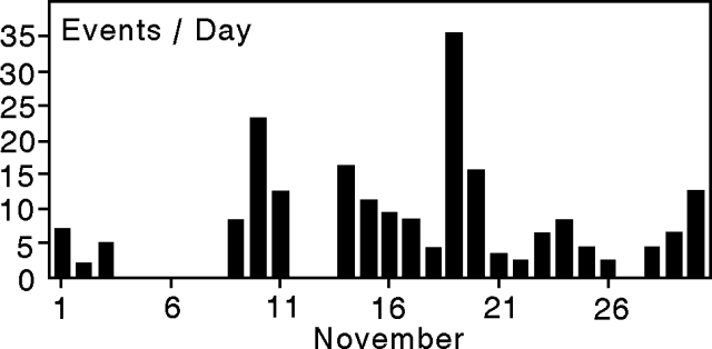 |
Figure 65. Arenal seismic events for November 1993 (received at station "VACR," 2.7 km NW of the active crater). Courtesy of OVSICORI. |
In contrast with the low number of seismic events, in November scientists reported high tremor (figure 66). The duration of tremor in November reached over 400 hours, a significant rise over the last several months. For comparison, tremor duration in 1993 reached its low in September at slightly over 100 hours, and reached its high in August at ~430 hours. In October and November lava issued from near 1,600 m elevation at the active vent, Crater C, and crept farther NE along the Tabacón river valley near 700 m elevation. Thus, the high tremor appears to correspond with continued lava emission, a common observation at Arenal.
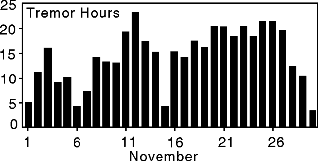 |
Figure 66. Arenal tremor duration for November 1993. Courtesy of OVSICORI. |
Crater C generated a moderate explosion on 28 August, and since that time chiefly Strombolian-style eruptions have prevailed. On 24 August, 4 days before the explosion and the associated partial collapse the NW crater wall, OVSICORI found an usually large sub-radial length contraction in the SW quadrant. A length contraction corresponds to an inflation of the edifice. The length contraction (116 ± 3 ppm) was followed on 17 October by a length extension (102 ppm). Between 17 October and 5 December, tilt and deformation measurements in the SW quadrant revealed a 24.4 µrad deflationary tilt (equivalent to 5.0 ppm/month). Thus, deformation studies indicated that the SW quadrant inflated before the eruption and deflated after the eruption. These observations are consistent with transport and continued expulsion of molten material.
Information Contacts: E. Fernández, J. Barquero, R. Van der Laat, F. de Obaldia, T. Marino, V. Barboza, and R. Sáenz, OVSICORI.
Lava flows continue; summary of 1993 behavior
Relatively quiet conditions prevailed at Arenal in December 1993 and most of January 1994. Starting on 28 January, both Strombolian activity and pyroclastic output increased. These outbursts were noted in La Palma, a village 4 km N of Crater C, where explosions vibrated the glass windows of houses.
Arenal continued its ongoing emission of gases and lava from its active vent, Crater C, situated just W of the summit. Some basic observations were made in the interval January 1993 through January 1994. Crater C emitted lava that flowed toward the S, SW, W, and NW. Strombolian eruptions produced columns that reached as high as several kilometers above the crater. Ash chiefly fell toward the NW, W, and SW, and noticeable amounts fell as far away as 25 km WNW (Tronadora), and 28 km W (Tilarán). Pyroclastic flows mainly traveled towards the NW, W, SW, S, and SE. The most noteworthy pyroclastic flow of the interval took place on 28 August; the same eruption also produced an accretionary lapilli fall deposit.
Figure 67 shows seismicity and tremor at Arenal for January 1993 through January 1994. The OVSICORI seismic station functioned for 19 days in January. During this time it registered an average of 15.8 earthquakes/day. Assuming the 19 days suitably reflect the average seismicity for the whole month, the estimated number of January events is 491 (figure 67). This estimate is in rough accord with an unbroken record of January seismicity at the ICE station ("La Fortuna," located 3.5 km E of Crater C). A similar averaging and readjustment procedure was also applied for tremor, and again this is in rough accord with the record seen at the ICE station.
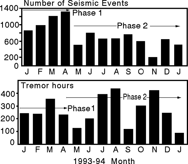 |
Figure 67. Number of seismic events and tremor duration at Arenal for January 1993 through January 1994 (received at station "VACR," 2.7 km NW of the active crater). The intervals phase 1 and 2 are discussed in the text. Courtesy of OVSICORI. |
The seismicity for January 1993 through January 1994 was divided into two phases. The interval January-April 1993, termed Phase 1, had the most explosive behavior. Phase 1 was characterized as follows: a) seismicity typically in the range of 27-44 events/day, b) seismic signals predominantly in the high-to-moderate frequency range, c) high sound levels, and d) explosions, sometimes accompanied by pyroclastic flows.
The interval May 1993-January 1994 was termed Phase 2. It was characterized as follows: a) an average of 7-26 seismic events/day, b) seismic signals of low-frequency, short duration, and low amplitude, and c) intermediate sound levels described as like those of a jet or locomotive. Phase 2 also had relatively low numbers of seismic events and the most pronounced highs in tremor duration, the latter associated with lava emission.
Scientists at OVSICORI described the eruptive behavior of Arenal based on the following model of the magma conduit. Phase 1 behavior, when major explosions took place, resulted from a more restricted conduit. Phase 2 behavior, characterized by jet and locomotive sounds, high tremor, and common lava emissions, resulted from a less restricted conduit.
Information Contacts: E. Fernández, J. Barquero, R. Van der Laat, F. de Obaldia, T. Marino, V. Barboza, and R. Sáenz, OVSICORI; G. Soto, G. Alvarado, and F. Arias, ICE; H. Flores, Univ de Costa Rica.
Vigorous venting of gas and emission of lava flows from Crater C
In March, . . . Crater C continued to emit gases, lava, and sporadic Strombolian eruptions. Lava progressing toward the NE and the Tabacón valley flowed along the same drainages in early 1994 as in 1993. A lobe branched off at 840 m elev and advanced separately. The front of the older, main flow has remained stationary at 620 m elev, 2.4 km from the source vent. Ash columns ascended up to 1 km above crater C; falling blocks and bombs reached 1,100 m elev (several hundred meters above the base of the edifice). Near the explosive vent, the erupted material built a small, blocky, dome-like structure. During March the seismic station VACR recorded 1,011 seismic events and 101 hours of tremor (figure 68). Sampling in early April revealed no new changes in temperature or acidity of hot and cold springs around the volcano.
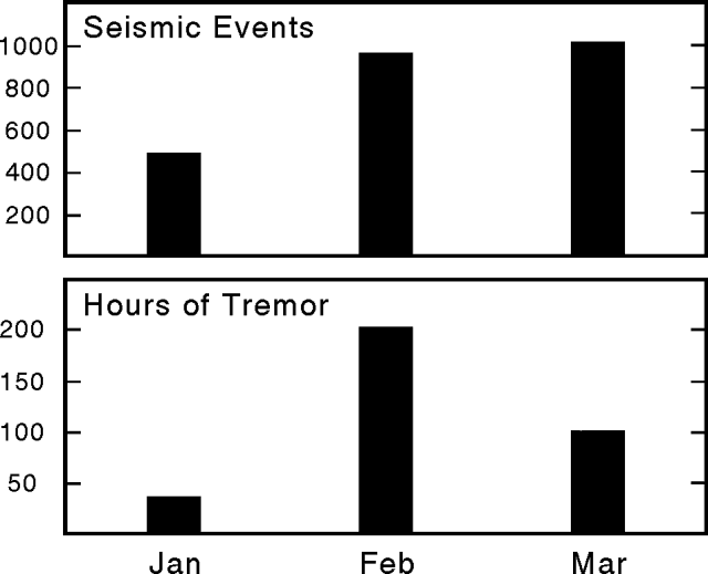 |
Figure 68. Arenal seismic events and duration of tremor for January, February, and March of 1994 (received at station "VACR," 2.7 km NW of the active crater). Courtesy of OVSICORI. |
Information Contacts: G. Soto, G. Alvarado, and F. Arias, ICE; E. Fernández, J. Barquero, R. Van der Laat, F. de Obaldia, T. Marino, V. Barboza, and R. Sáenz, OVSICORI.
Continued sporadic Strombolian eruptions and emission of gases and lava
The active Crater C continued to emit gases and lava, and was the site of sporadic Strombolian eruptions. Crater D continued fumarolic degassing. The lava that began to exit from crater C at the end of December remained active along its two NW-flowing channels. These divided at 1,100 m elev, forming two arms that in April extended to 900 m and 750 m elev. The temperature and pH of hot and cold springs around the volcano remained stable during early April sampling.
Compared to previous months, the Strombolian eruptions that had accompanied strong rumbling have diminished in both number and magnitude. On days with good visibility observers on the W flank saw Arenal noiselessly send up small, ash-bearing eruptions that rose to 300 m above the rim of Crater C.
In April, low-frequency seismic events took place 621 times, and harmonic tremor lasted for 57 hours. Relative to previous months, there was a decrease in the duration of tremor with frequencies below 3 Hz.
Information Contacts: E. Fernández, J. Barquero, V. Barboza, and W. Jiménez, OVSICORI; G. Soto, G. Alvarado, and F. Arias, ICE; H. Flores, Univ de Costa Rica.
Lava flows, "mute" events, and damage from gas emissions
During May, Crater C continued its continuous emission of gases, lava flows, and sporadic Strombolian-style eruptions. The lava flows that began to exit in late December (1993) and late April (1994) both continued to move, but some of the smaller lobes had stopped. Though not erupting, Crater D maintained fumarolic activity.
During May, Strombolian eruptions remained low in number and magnitude. As in April, erupted ash reached 100-200 m above Crater C, but no explosive noises were evident ("mute" events). In late June, ICE geologists saw an average of one eruption every half hour, ejecting ash plumes up to 1,200 m above the crater.
During May, the OVSICORI seismic station ("VACR," located 2.7 km NE of the main crater) registered 831 events with frequencies of 1.7-2.3 Hz; the majority of these were associated with eruption of gas and pyroclastics (figure 69). The number of hours of harmonic tremor received for the month was relatively low (a total of 29 hours, figure 69c). Several peaks and troughs in seismic activity took place during the course of the month (figure 69c). The greatest duration of tremor took place around the 12th, when seismicity was moderate to low. A comparison with May data collected at the ICE seismic station ("La Fortuna," 3.5 km E of Crater C) shows good agreement in terms of seismic events and tremor near the middle of the month, but less agreement early and late in the month.
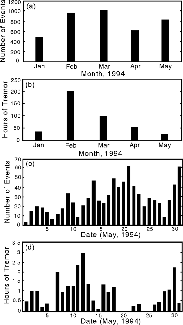 |
Figure 69. Seismicity and duration of tremor at Arenal, as follows: (a and b) monthly summary for January-May 1994, (c and d) daily summary for May 1994. Courtesy of OVSICORI. |
During April and May, surveys of both a W-flank trigonometric-leveling line and the distance-measurement network showed no significant changes.
Information Contacts: G. Soto, G. Alvarado, and F. Arias, ICE; H. Flores, Univ de Costa Rica; E. Fernández, J. Barquero, V. Barboza, and W. Jiménez, OVSICORI.
Lava flows, gas emissions, and sporadic Strombolian eruptions
During June, Crater C continued to emit gases, lava flows, and sporadic Strombolian-style eruptions. The lava flow that emerged in December, and took a more westerly course, stopped at an elevation of 800 m. The flow that emerged in late April followed the same channel as a previous flow and remained active to an elevation of 1,000 m. At ~1,300 m elev small blocky flows escaped the confines of bounding levees.
OVSICORI scientists reported that during June, Strombolian eruptions were both infrequent and small. ICE scientists watched ash plumes escape at rates averaging once each half-hour; these plumes rose up to 1,200 m above the crater. Though not erupting, Crater D maintained fumarolic activity.
During a 10-day period in June, a total of 227 earthquakes were recorded. The earthquakes mainly fell in the 1.2-2.6 Hz range. Tremor was also relatively rare; during these 10 days of recording, it remained below 2 Hz and totaled only 6 hours.
Information Contacts: E. Fernández, J. Barquero, R. Van der Laat, F. de Obaldia, T. Marino, V. Barboza, and R. Sáenz, OVSICORI; G. Soto, G. Alvarado, and F. Arias, ICE; H. Flores, Univ de Costa Rica.
Continued gas and lava emissions; sporadic Strombolian eruptions
At . . . Crater C, July marked another month of continued gas and lava emissions, and sporadic Strombolian eruptions. During July, the lava flow that began at the end of April continued to erupt and flow down an established channel. During 23 days in July, seismic station VACR (2.7 km NE of crater C) recorded an average of 18 events/day. These were interspersed with days having very low seismicity and tremor. Beginning on 23 July, Strombolian-type eruptions became common, and during 23-30 July they were seen 52 times. In some cases these eruptions were accompanied by sounds similar to a jet or steam engine. On 28 July tremor reached an amplitude of 27 mm at a frequency below 2.5 Hz.
Information Contacts: E. Fernández, J. Barquero, V. Barboza, R. Van der Laat, F. de Obaldia, and T. Marino, OVSICORI; G. Soto, G. Alvarado, and F. Arias, ICE; M. Mora, C. Ramirez, and G. Peraldo, Univ de Costa Rica.
Lava flows remain active and produce rockfalls from flow-front collapses
Strombolian eruptions and lava output from Crater C continued in August-September, while Crater D exhibited fumarolic activity. The new lava flow observed in July on the high W flank stopped in August. However, the composite lava flow active since 28 August 1993 formed two new lobes that overflowed levees around 1,200 m elev. In August-September a cone in Crater C, new lava flows, and pyroclastic materials had covered and filled the bulk of the amphitheater opened by the August 1993 event.
ICE scientists noted that explosive activity in August was similar to July, although volcano-seismic activity declined. On 11 and 15 August the number and size of explosions escalated, vibrating windows and other infrastructure at a settlement 4 km from the active crater. Some of these events were detected seismically 30 km away (station Las Juntas de Abangares).
In September, explosions were fewer in number, of lower magnitude, and they carried smaller amounts of pyroclastic material. The lobes of the 28 August 1993 lava flow remained active in September. Several flow-front collapses, resembling pyroclastic flows, were witnessed during September. The largest such witnessed event (1600, 29 September), resulted in a 500-m-high, reddish-brown ash cloud. In addition, some "noisy" seismic signals recorded by ICE may have been caused by similar unwitnessed collapse events. Summit fumarolic activity remained very vigorous. Explosive activity was similar to previous months. Volcano-seismic events decreased to an average of 55/day, and tremor declined slightly to 58 minutes/day. On the SE, E, and NE flanks the vegetation continued to recede because of the effects of acidic rain, rock falls, and other factors such as high rainfall, which had induced small cold avalanches (specifically down Calle de Arena, Guillermina, and Agua Caliente rivers).
On average, 76 daily seismic events were recorded by ICE during August, compared to 104 in July and 73 in June; daily number of tremor hours averaged ~1.3, similar to July. During September, 620 seismic events (1.5-2.5 Hz frequencies) were recorded by OVSICORI-UNA, and were thought to correlate chiefly to gas-dominated eruptions, or in some cases to gas-and-ash eruptions. Sounds associated with these eruptions were similar to a jet or steam locomotive. Sporadic tremor took place in the 1.3-3.0 Hz frequency range; total tremor duration for September was 99 hours. During August-September, distance and dry tilt measurements failed to show significant changes.
Information Contacts: E. Fernandez, J. Barquero, V. Barboza, R. Van der Laat, T. Marino, F. de Obaldia, and L. Carvajal, OVSICORI; G. Soto, W. Taylor, F. Arias, G. Alvarado, and R. Barquero, ICE; M. Mora, Univ de Costa Rica.
Lava flows and modest explosions continue
Continuing activity in September consisted of Strombolian eruptions and lava output from Crater C and fumarolic activity from Crater D. Two lobes of lava continued to progress toward the Tabacón valley (figure 70). ICE workers suggested that at elevations below 800 m the estimated velocities of lava flows have averaged roughly 2.5 m/day. In some of the steeper upslope reaches flows may have averaged as much as roughly 50 m/day, but velocities were more typically 10-20 m/day. These values are approximate, because field work is hampered by hazards associated with sudden collapse of lava-flow fronts.
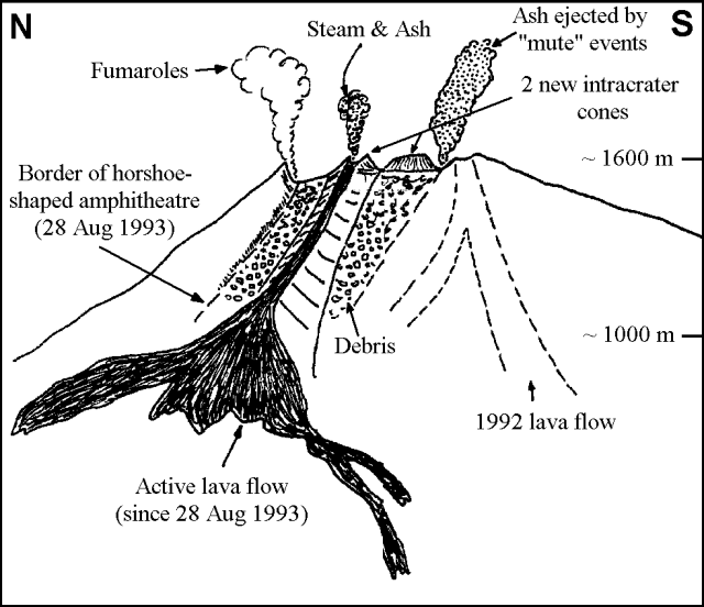 |
Figure 70. Rough field sketch of Arenal, from the ash-sampling locality mentioned in the text (1.8 km W of the summit); view is toward the E. Courtesy of G. Soto, ICE. |
In the summit crater, vents active for the past several months had built two small cones. The northernmost cone extruded lava during the past several months. The southerly cone appears to be mainly composed of pyroclastic materials. Toward the crater's center there was a third vent. Summit fumaroles remained vigorous and occasional explosions took place (table 6); at night a red glow still prevailed over the crater area suggesting ponded lava remains molten there. Seismicity reported by ICE appears in table 7; their mid-October sampling found that both pH values and water temperatures remained unchanged.
Table 6. Ash collected downwind at a spot 1.8 km W of Arenal's crater. "Collection Interval" refers to the time period in 1994 when the ash sample accumulated (also shown as "Days," the number of days), but the mass/area value is a computed daily average. Courtesy of G. Soto, ICE.
| Collection Interval | Days | Mass/Area (grams/m2-day) | % Fine (250-125µ) | % Very Fine (less than 124µ) |
| 27 Mar-08 Jun 1994 | 73 | 14.1 | 21 | 60 |
| 08 Jun-05 Aug 1994 | 58 | 6.0 | 10 | 76 |
| 05 Aug-15 Oct 1994 | 75 | 3.6 | 61 | -- |
Table 7. Number of seismic events and tremor duration at Arenal. October values are extrapolated from 20 days of observations. Courtesy of ICE.
| Month | Number of Events | Hours of Daily Tremor |
| Jul 1994 | 104 | 1.3 |
| Aug 1994 | 76 | 1.3 |
| Sep 1994 | 55 | 0.94 |
| Oct 1994* | 82 | 1.1 |
OVSICORI-UNA reported that September seismic events often accompanied gas- and ash-bearing eruptions. During September seismic events in the frequency range 1.2-2.5 Hz totaled 657; tremor duration totaled 55 hours.
Information Contacts: E. Fernández, J. Barquero, and V. Barboza, OVSICORI; G. Soto and F. Arias, ICE; M. Mora, Univ de Costa Rica.
Ongoing Strombolian activity and a deflating edifice during 1994
Strombolian eruptions and lava output from Crater C continued in November with columns reaching as high as 1 km above the Crater. OVSICORI reported that during 1994 the following accumulated deflations took place: a) the W-flank leveling line, 7.8 µrad; b) the inclination network, 7.7 µrad; and c) the distance network, 28.6 and 18.5 ppm (SW- and S-flanks, respectively). ICE reported that seismicity for November 1994 was comparatively low (table 8).
Table 8. ICE reported seismicity for Arenal, fall 1994. Their seismometer sits 1.5 km from Crater C. * November seismicity extrapolated based on 15 days of data. Courtesy of G. Soto.
| Month | Number of Events | Hours of Daily Tremor |
| Jul 1994 | 104 | 1.3 |
| Aug 1994 | 76 | 1.3 |
| Sep 1994 | 55 | 0.94 |
| Oct 1994 | 53 | 1.1 |
| Nov 1994* | 56 | 0.24 |
Information Contacts: E. Fernández, J. Barquero, R. Van der Laat, F. de Obaldia, T. Marino, V. Barboza, and R. Sáenz, OVSICORI; G. Soto, Guillerma E. Alvarado, and Francisco (Chico) Arias, ICE.
Continued lava flows and mild Strombolian eruptions
Strombolian eruptions and lava output from Crater C continued in December with columns reaching as high as 1 km above the crater. Both the magnitude and number of explosions increased in December compared to those seen in November. OVSICORI reported that lava flows discharged from Crater C divided at ~1,200 m elev forming three arms: one reaching 950 m (NW arm), and the other two, 1,100 m (W and SW arms).
Information Contacts: OVSICORI.
Continued Strombolian eruptions and lava output
Strombolian eruptions and lava output from Crater C continued in January with columns reaching as high as 1 km above the crater. In the village of La Palma, located 4 km N of the volcano, the eruptions vibrated windows. OVSICORI-UNA reported that lava continued to extrude in October 1994. The lava flow branched into three lobes; in January 1995 the flow's N lobe reached down to ~900 m elevation, and the W and SW lobes, to ~1,050 m elevation.
OVSICORI-UNA registered 577 seismic events of low frequency (<3.0 Hz) during January. The majority of these events were correlated with near-synchronous tephra-bearing eruptions. During January, tremor took place for 115 hours, a duration similar to March 1994. Much of the tremor arrived between 2 and 9 January, an interval when the number of the low-frequency earthquakes was low (typically <5/day). Just over 40 low-frequency earthquakes took place on 14 January, the highest number recorded for any day of the month. Except for the lull early in the month, the number of earthquakes each day was typically between ~10 and 25.
ICE reported relatively weak effusion of lava in mid- and late-January, but in the same interval, explosive activity remained the same as in recent months. They suggested that following this interval there were stronger Strombolian eruptions between longer repose intervals.
Information Contacts: E. Fernández, J. Barquero, R. Van der Laat, F. de Obaldia, T. Marino, V. Barboza, and R. Sáenz, OVSICORI; G. Soto, ICE.
Eruptions and lava flows continue; ash deposition rate quantified
Crater C continued its ongoing emission of gases, lava flows, and sporadic Strombolian eruptions. The Strombolian eruptions remained similar to those of January, with ash columns reaching up to 1 km above the crater. These eruptions vibrated windows in the village of La Palma 4 km from the volcano. Falling bombs and blocks reached 1,000 m elev, ~660 m below the summit. Crater D continued fumarolic activity. Moderate low-frequency (<3 Hz) seismicity continued to decrease during March, but tremor duration remained high (figure 71).
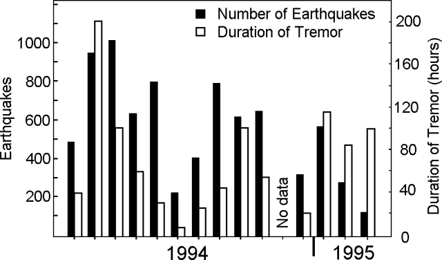 |
Figure 71. Arenal low-frequency seismicity for 1994 and January-March 1995. Data courtesy of OVSICORI. |
The record of ash deposition 1.8 km W of the vent (table 9) shows, in terms of total mass, that the deposition rate has increased since October 1994. Daily deposition after 3 March was 22.7 g/m2, compared to a daily average of only 7.6-8.2 g/m2 between 19 October 1994 and 3 March 1995.
Table 9. Ash collected 1.8 km W of Arenal's active vent. Courtesy of G. Soto, ICE.
| Collection Interval | Avg daily ashfall (grams/m2) | Ash % 300+µ | Ash % less than 300µ |
| 19 Oct 94-23 Jan 1995 | 7.6 | 38.0 | 62.0 |
| 23 Jan 95-03 Mar 1995 | 8.2 | 54.7 | 45.3 |
| 03 Mar 95-30 Mar 1995 | 22.7 | 42.2 | 57.8 |
Information Contacts: E. Fernández, V. Barboza, and J. Barquero, OVSICORI; G. Soto, ICE.
Gas analysis; high tremor and a large explosion
During April, Crater C continued its ongoing emission of gas, lava flows, and small Strombolian eruptions. The lava flow that started in October 1994, reached 1,100 m elevation along the W arm and at 850 m elevation along the NW arm. On Arenal's NW, W, and SW flanks the tips and borders of tree leaves showed signs of scalding by acidic rain; some species were merely discolored, others were dying.
During April, a total of 484 low-frequency seismic events took place (figure 72); the majority of these events correlated with Strombolian eruptions; some events were registered as far away as 30 km SW of the active crater (station JTS). In terms of total (broad-band) seismicity, the most seismically active single day was 30 April, with 53 events registered.
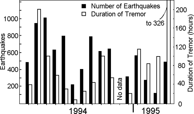 |
Figure 72. Arenal low-frequency seismicity for 1994 and January-April 1995. Data courtesy of OVSICORI-UNA. |
According to OVSICORI-UNA, tremor prevailed during April for a total of 326 hours, 160% larger than any month (with data) in 1994 and thus far in 1995 (figure 72). At station JTS the tremor's dominant frequency fell between 2.0 and 3.2 Hz, its amplitude was as large as 101 mm.
ICE reported that average daily ashfall near the vent fluctuated significantly in the past few collection intervals (table 10). In three of the four collection intervals, the percentage of material above and below a quarter of a millimeter (250 µm) typically broke down in a roughly 40:60 ratio (coarse to fine).
Table 10. Ash collected 1.8 km W of Arenal's active vent, 19 October 1994 through 21 April 1995. Courtesy of ICE.
| Collection Interval | Avg daily ashfall (grams/m2) | Ash % 300+µ | Ash % less than 300µ |
| 19 Oct-23 Jan 1995 | 7.6 | 38.0 | 62.0 |
| 23 Jan-03 Mar 1995 | 8.2 | 54.7 | 45.3 |
| 03 Mar-30 Mar 1995 | 22.7 | 42.2 | 57.8 |
| 30 Mar-21 Apr 1995 | 16.3 | 39.5 | 60.5 |
On 9 May at 2003, one of the biggest explosions in the last year and a half took place--sufficiently large to capture the attention of local newspapers. The amplitude of the accompanying seismic signal recorded 23 km W of Arenal reached ~20x larger than a "normal explosion"; the signal took ~0.3 seconds to grow to maximum amplitude. The elevated signal from the 9 May seismic event lasted >1.2 minutes; in contrast, at this same station the elevated signal from a normal explosion lasts perhaps 0.1 minute.
Robust, monochromatic, 2.5 Hz tremor took place at least 40 minutes prior to the 9 May event. After the event, the tremor became spasmodic, and although the bulk of the energy remained at 2.5 Hz, there was also some centered around 2.0 and 3.2 Hz.
Glyn Williams-Jones and John Stix sent the following. "During the period from 20 February to 20 April 1995, CO2 and Rn soil gas samples and correlation spectrometer SO2 fluxes were measured on Arenal. Four lines of 19 soil gas stations consisting of meter-long, 7.6-cm-diameter PVC tubes and 1-cm-diameter metal tubes, buried to approximately 75 cm in the ground, were installed on the N, S, W, and E flanks of the volcano.
"Radon values are extremely low, ranging from 2values show a similar pattern, with proximal stations starting at 0.01% to a maximum of ~8% for the more distal stations. The more developed organic-rich soils appear to show higher values of CO2 and Rn, implying a possible organic or soil influence.
"The SO2 flux in the volcanic plume was measured using a Plume Tracker instrument, similar to a COSPEC correlation spectrometer. The instrument was mounted 'looking up' on a moving motor vehicle passing under the plume. Eleven days of SO2 data were collected, resulting in more than 100 measurements. The flux appears to be small but highly variable, with the highest measured value at 370 metric tons/day (t/d). The highest values were associated with explosive eruptions. Following eruptions, SO2 flux dropped to background levels of about 60 +- 10 t/d. Less apparent from the data is a possible gradual increase in SO2 output prior to an eruption.
"The values that we measured are comparable to those measured by Casadevall and others (1984) in 1 February 1982 (210 +- 30 t/d) and by Stoiber and others (SEAN 07:11) in November 1982 (~50 t/d). It is likely that these variations are related to changes in the volcano's activity."
Arenal's first chronicled eruption, in 1968, began an unbroken sequence of Strombolian explosions, and basaltic andesite discharges from multiple vents (see map in BGVN 18:08). The volcano lies adjacent to Lake Arenal, a dammed reservoir for generating hydroelectric power.
References. Casadevall, T.J., Rose, W.I., Fuller, W.H., Hunt, W.H., Hart, M.A., Moyers, J.L., Woods, D.C., Chuan, R.L., and Friend, J.P., 1984, Sulfur dioxide and particles in quiescent volcanic plumes from Póas, Arenal, and Colima volcanoes, Costa Rica and Mexico: J. Geophys. Res., v. 89, p. 9633-9641.
Information Contacts: Erick Fernandez, Vilma Barboza, and Jorge Barquero, Observatorio Vulcanologico y Sismologico de Costa Rica, Universidad Nacional (OVSICORI-UNA), Apartado 86-3000, Heredia, Costa Rica; G.E. Alvarado, Waldo Taylor, and Gerardo J. Soto, Oficina de Sismologia y Vulcanologia del Arenal y Miravalles: OSIVAM; Instituto Costarricense de Electricidad (ICE), Apartado 10032-1000, San José, Costa Rica; Glyn Williams-Jones and John Stix, Departement de Geologie, Universite de Montreal, Quebec, Canada, H3C 3J7.
Strombolian eruptions, lava flows, and deflation continue
The lava flow first emitted in April 1995 trended W and branched into two arms at 1,150 m elevation. During May one of these branches progressed to the 1,050-m elevation, and the more SW-directed flow progressed to 950 m elevation. During June, these same two branches descended to the 1,000- and the 800-m elevations, respectively. In June, the lower flow measured 23-25 m thick, and 50-m wide.
During May, there were increases in the number of eruptions, their sound intensity, and the amount of ash in eruptive columns; in both May and June some ash column heights ascended to over 1 km above Crater C. Fumarolic activity continued at Crater D during May and June.
ICE reported that from late April through most of June the amount of ash collected 1.8 km W of the active vent remained relatively high, 15-38 grams/m2 (table 11). Shifting wind directions brought ash to the village of La Fortuna, 6.5 km E of Arenal. Ashfall was reported in Arenal's NW, W, and SW sectors, and infrequently in the S sector.
Table 11. Ash collected 1.8 km W of Arenal's active vent; note the corrected grain size of 300 µm (rather than 250 µm) also applies to tabled data in previous reports. Courtesy of Gerardo Soto, ICE.
| Collection Interval | Avg daily ashfall (grams/m2) | Ash % 300+µ | Ash % less than 300µ |
| 21 Apr-23 May 1995 | 37.6 | 51.1 | 48.9 |
| 23 May-29 Jun 1995 | 15.4 | 51.2 | 48.8 |
Seismic activity in May consisted of 866 events (low frequency-3.5 Hz range), mainly associated with Strombolian eruptions. Some events were sufficiently large to be detected 30 km SW of Crater C (station JTS). On the most seismically active day of the month, 7 May, there were 50 events. June seismic activity consisted of 1,027 events.
Tremor took place during May for 419 hours, and during June for 402 hours. The tremor signal was centered between 2 and 3.2 Hz, with amplitudes in May reaching over 100 mm, and in June, typically in the 50-80 mm range. The relatively large tremor in May was also registered at the more distant station JTS.During April and May the leveling network continued to show an average deflation of 15 microrad, a continuation of the tilt direction and magnitude witnessed in previous years. Surveys of the distance measuring network in 1994 and principally in 1995 registered a contraction of 15 ppm/year. A local reversal of this trend was seen between 17 and 25 May 1995 when one of four distances measured on the S flank revealed a 23 ppm expansion.
Arenal's first historical eruption, in 1968, began an unbroken sequence of Strombolian explosions and basaltic andesite discharges from multiple vents. The volcano has been watched by many tourists from a mountain lodge 2.8 km S of the vent that enables visitors to hear, to see, and occasionally to smell its dynamism.
Information Contacts: E. Fernandez, R. Van der Laat, F. de Obaldia, T. Marino, V. Barboza, W. Jimenez and R. Saenz, Observatorio Vulcanologico y Sismologico de Costa Rica, Universidad Nacional (OVSICORI-UNA), Apartado 86-3000, Heredia, Costa Rica; Mauricio Mora, Escuela Centroamericana de Geologia, Universidad de Costa Rica; J.F. Arias, L.A. Madrigal, and G.J. Soto, Oficina de Sismologia y Vulcanologia del Arenal y Miravalles: OSIVAM, Instituto Costarricense de Electricidad (ICE), Apartado 10032-1000, San José, Costa Rica.
Crater C continues to emit lavas and Strombolian eruptions
During July, craters C and D continued to emit gases, and Crater C generated lava flows and sporadic Strombolian eruptions. The lava flow that started in May continued to move, but during June its SW arm only advanced ~180 m. During June this arm had a 52-m width and terminated at the 760-m elevation with the final 100 m of its length inclined 10-12° downward. A newer flow began to be extruded into a previously active channel and reached ~1,100 m elevation; the front of this flow produced small avalanches. Distance measurements revealed a transitory expansion of the edifice beginning in March 1995 and attaining an average maximum of ~20 ppm on about 25 May. Measurements in early July showed a return to the previous tendency of contraction. Ashfall was again measured W of the crater (table 12).
Table 12. Ash collected 1.8 km W of Arenal's active vent. Courtesy of Gerardo Soto, ICE.
| Collection Interval | Avg daily ashfall (grams/m2) | Ash % 300+µ | Ash % less than 300µ |
| 21 Apr-23 May 1995 | 37.6 | 51.1 | 48.9 |
| 23 May-29 Jun 1995 | 15.4 | 51.2 | 48.8 |
| 29 Jun-27 Jul 1995 | 17.5 | 19.3 | 80.7 |
Arenal's recent lavas have had basaltic andesite compositions. The volcano lies directly adjacent to Lake Arenal, a dammed reservoir that generates hydroelectric power.
Information Contacts: E. Fernandez, R. Van der Laat, F. de Obaldia, T. Marino, V. Barboza, W. Jimenez and R. Saenz, Observatorio Vulcanologico y Sismologico de Costa Rica, Universidad Nacional (OVSICORI-UNA), Apdo. 86-3000, Heredia, Costa Rica; Mauricio Mora, Escuela Centroamericana de Geologia, Universidad de Costa Rica; Gerardo J. Soto, Observatorio Sismologico y Vulcanologico del Arenal y Miravalles (OSIVAM), Instituto Costarricense de Electricidad (ICE), Apdo. 10032-1000, San José, Costa Rica.
Ongoing eruptions; high earthquake and tremor counts
In August, Crater C continued its regular emission of gases, lava, and sporadic Strombolian eruptions; in addition, there were occasional lava avalanches. Lava that began to be emitted in May 1995 followed a course toward the SW and flowed down as far as 720 m elevation. Lava emitted a month earlier branched into two arms at ~1,300 m elevation. Explosions sent columns to 1 km above the active vent. These columns were typically blown to the NW, W, and SW; however, some minor local ashfalls also took place on the N and NE as well.
During August, OVSICORI-UNA reported comparative highs in both the number of seismic events (925) and the duration of tremor (348 hours). No seismic data are currently available for July 1995. Comparing the available record starting in January 1994, greater numbers of seismic events took place only in February and March 1994 (956 and 1,011 events) and in June 1995 (1,027 events). For the same interval, tremor prevailed longer only in May and June 1995 (419 and 402 hours, respectively).
A May explosion of >1.2 minutes duration and a plot of the available 1994-95 seismic record were both discussed in BGVN 20:04. The volcano's first chronicled eruption occurred in 1968 and many basaltic andesite discharges have followed since then.
Information Contacts: E. Fernandez, E. Duarte, R. Saenz, W. Jimenez, and V. Barboza, Observatorio Vulcanologico y Sismologico de Costa Rica, Universidad Nacional (OVSICORI-UNA), Apartado 86-3000, Heredia, Costa Rica.
Gas and lava emissions; some Strombolian eruptions and pyroclastic flows
In September, Arenal's active vent, crater C, continued its regular emission of gases, lava, and sporadic Strombolian eruptions; in addition, there were occasional pyroclastic flows. Lava that began to be emitted in July 1995 followed a course toward the SW and by the end of September had flowed to 1,050-m elevation. By the end of September, lava moving NW reached 800 m elevation. At the 1,400-m elevation a new arm branched off; it trended SW and by the end of September had reached 1,200 m elevation.
Explosions in September sent columns >1 km above the active vent that were typically blown to the NW, W, and SW. Toward the end of the month, some ash also fell on the NE and E flanks. Bombs and blocks arrived at elevations as low as 1,200 m. Crater D was fumarolically active.
During September there were 977 seismic events and 223 hours of tremor (figure 73). The majority of the seismic events were associated with Strombolian eruptions. Some of these eruptions were large enough to register at an outlying station 27 km more distant from Arenal than the one usually used (station JTS, 30 km SW of the crater). The total number of events (figure 73) for February and March were extrapolated based on 9 and 19 days, respectively, of recorded data.
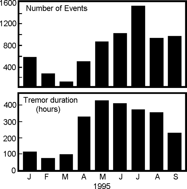 |
Figure 73. Seismic events and tremor at Arenal, January-September 1995, recorded at Station VACR (2.7 km NE of the main crater). Courtesy of OVSICORI-UNA. |
A pulse of expansion detected in May 1995 ceased, and in September distance lines returned to a tendency toward long-term contraction (13 µrad/year). With the exception of one dry tilt instrument, which indicated deflation at 12 µrad/year on the W flank, there were no significant measured changes in tilt.
A brilliant color photograph of Arenal erupting appeared on the front page of the Washington Times on 22 September. Without either objects for scale or accompanying clarifying text, the photo caused considerable short-term confusion about the volcano's status. It was quickly learned that the photo depicted typical conditions at the volcano and observers in Costa Rica had not witnessed increases in activity. The volcano's first chronicled eruption took place in 1968 and many basaltic andesite discharges have followed.
Information Contacts: E. Fernandez, E. Duarte, R. Saenz, W. Jimenez, and V. Barboza, Observatorio Vulcanologico y Sismologico de Costa Rica, Universidad Nacional (OVSICORI-UNA), Apartado 86-3000, Heredia, Costa Rica.
Explosive activity increase from October; lava flows continue
October plumes rose as high as 1 km above Crater C. During the second week of November explosive activity increased, growing both in terms of the number of outbursts and the overall quantity of tephra emitted. Blocks and bombs landed above 1,000 m elevation. Ash columns rose over 1 km and blew over the NW, W, and SW flanks. Windows vibrated in buildings 6.5 km E (La Fortuna).
A lava flow first emitted in July remained mobile; one arm reached 860 m and another reached 900 m elevation. A new flow began at the end of the month, venting from a point S of the vent for the previous month's flow, and moving SW. Re-established vegetation in the zone of lava flows continued to degrade due to acid rain.
For the frequency range below 3.5 Hz, there were 765 events during October and 444 seismic events during November (figure 74). These events chiefly occurred associated with Strombolian eruptions; some were of sufficient amplitude to reach station JTS, 30 km from the active crater. The largest number recorded in a single day was 40 (on 5 November). During October and November, 2.1-3.5 Hz tremor took place for about 232 and 238 hours, respectively (figure 74). On 15 and 17 November tremor prevailed for 21 and 20 hours, respectively.
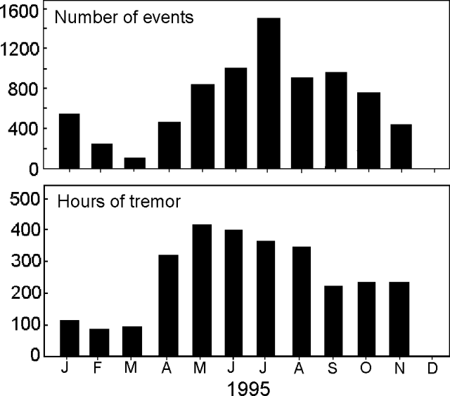 |
Figure 74. Arenal seismicity and tremor for 1995 (recorded at station "VACR," 2.7 km NE of the main crater). Courtesy of OVSICORI-UNA. |
Information Contacts: E. Fernandez, E. Duarte, R. Saenz, W. Jimenez, and V. Barboza, Observatorio Vulcanologico y Sismologico de Costa Rica, Universidad Nacional (OVSICORI-UNA), Apartado 86-3000, Heredia, Costa Rica.
Small Strombolian eruptions continue
During December 1995 and January 1996, Crater C continued its ongoing emission of gases, lava flows, and sporadic Strombolian eruptions. The intensity of Strombolian activity remained high, but showed some decline during this interval. Ash columns reached up to 1 km above the crater.
Lava that began extruding in July 1995 ceased advancing during much of January 1996. In contrast, new lava began extruding during January; it followed previously established channels and reached the 1,100-m contour.
During some past years, a general tendency toward deflation of the edifice had been noted. For the W and N sectors, inclinometers detected a 1995 deflation averaging 15.4 µrad/year. In harmony with this observed deflation, 1995 distance surveys over the local net registered an overall contraction of 21.2 ppm/year.
During December and January, seismic station VACR (2.7 km NE of the main crater) registered a moderate number of local events (figure 75). The majority of these events were thought to be associated with Strombolian eruptions; some were sufficiently strong to be recognized at station JTS (30 km SW of the crater). Tremor during these same two months registered for 306 and 420 hours, respectively (figure 75).
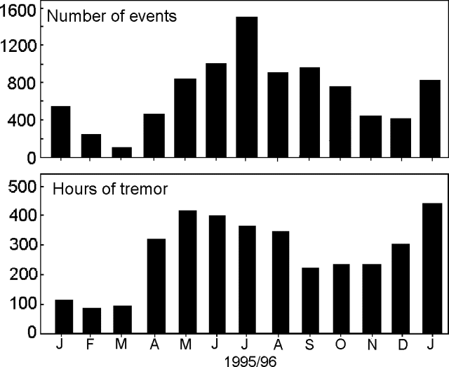 |
Figure 75. Arenal monthly low-frequency seismicity (<3.5 hz) and tremor, January 1995-January 1996. Data courtesy of OVSICORI-UNA. |
Information Contacts: Rodolfo Van der Laat, Vilma Barboza, Erick Fernández, Jorge Barquero, Franklin de Obaldia, Tomás Marino, and Rodrigo Sáenz, Observatorio Vulcanológico y Sismológico de Costa Rica, Universidad Nacional (OVSICORI-UNA), Apartado 86-3000, Heredia, Costa Rica.
Continued eruptions and recently updated map of lava flows
During February and March, Crater C continued to emit gas, lava, and sporadic Strombolian eruptions. For both months, OVSICORI-UNA reported that the intensity of explosive activity was slightly below that of January, however, columns still rose ~1 km. Prevailing winds blew towards the NW, W, and SW. Arenal continued to cause acidic rains and to eject volcanic bombs, blocks, and ash. The volcano's steep slopes and receding vegetation have led to gullying in unconsolidated material and cold avalanches down local drainages.
ICE reported the distribution of lava flows down Arenal's W slopes (figure 76). A flow active from May 1995 through early January 1996 ceased and a new one trending WNW began in late January, its downslope end reaching 1,200-m elevation in early March. Also, on the N flank in early March, some rolling blocks destroyed forest down to 1,150 m elevation. Deposits reminiscent of those from pyroclastic flows were found in late December at 950 m elevation.
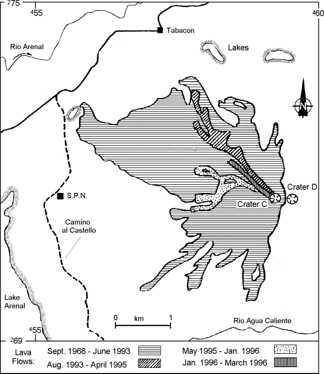 |
Figure 76. Sketch map of Arenal area showing distribution of lavas as of March 1996. Courtesy of G. J. Soto. |
ICE noted that December explosions were ~15-30 minutes apart; after mid-January the explosions were ~27 ± 21 minutes apart (1 sigma standard deviation); steam often vented in the N quadrant of Crater C. Nightime observers saw cyclic changes in the intensity of crater glow repeating every 39 ± 22 seconds; the changes were attributed to convection in the intra-crater lava pool. ICE also repeatedly measured ash deposition rates adjacent to the crater (table 13).
Table 13. Mass of Arenal's ash collected at a site 1.8 km W of the active vent. Courtesy of ICE.
| Collection Interval | Avg daily ashfall (grams/m2) | Ash % 300+µ | Ash % less than 300µ |
| 24 Aug-26 Sep 1995 | 20.7 | 36 | 64 |
| 26 Sep-23 Oct 1995 | 1.1 | 0 | 100 |
| 23 Oct-22 Dec 1995 | 24.2 | 56 | 44 |
| 22 Dec-06 Mar 1996 | 32.9 | 50 | 50 |
OVSICORI-UNA reported the respective values of tremor duration and local seismicity during February and March: 386 and 261 hours and 758 and 624 events. Events of frequency below 3.5 Hz typically accompanied those eruptions that ejected pyroclastics.
Information Contacts: Erick Fernández, Elicer Duarte, Vilma Barboza, Rodolfo Van der Laat, and Enrique Hernandez, Observatorio Vulcanológico y Sismológico de Costa Rica, Universidad Nacional (OVSICORI-UNA), Apartado 86-3000, Heredia, Costa Rica; Gerardo J. Soto, Oficina de Sismolog¡a y Vulcanolog¡a, Departamento de Geolog¡a, Instituto Costarricense de Electricidad (ICE), Apartado 10032-1000, San José, Costa Rica.
Tremor duration unusually large in April (434 hours), but normal in May (325 hours)
Fluctuations in the intensity and frequency of explosive activity were reported by OVSICORI-UNA. Activity during April increased above that of the previous several months but diminished during May. The April increase was accompanied by a corresponding rise in the amount of pyroclastic material produced; columns ascended over 1 km above Crater C in April and somewhat lower in May; these were commonly blown towards the NW, W, and SW. Ashfall measured at the ICE station 1.8 km W of the vent was higher during March-May than earlier in the year (table 14).
Table 14. Ash collected 1.8 km W of Arenal's active vent. Courtesy of Gerardo Soto, ICE.
| Collection Interval | Avg daily ashfall (grams/m2) | Ash % 300+µ | Ash % less than 300µ |
| 22 Dec-06 Mar 1996 | 33 | 50 | 50 |
| 06 Mar-15 Apr 1996 | 43 | 50 | 50 |
| 15 Apr-16 May 1996 | 48 | 56 | 44 |
During April and May, bombs and blocks fell to 1,200 m elevation. New pyroclastic-flow deposits were noted in April. Early April pyroclastic deposits descended the SW flank (to 1,000 m elevation) and those of late April descended the NW flank (to 1,250 m elevation). Light ash fell towards the N and NE in May.
Lava flows emitted in the previous month divided into two arms that both trended about NW. A new, NE-trending flow began during April and by the end of the month its front reached 1,200 m elevation. Sporadic avalanches fell off this front and sometimes reached into forested land. During May, continued descent of the flows to as low as 750 m elevation led to avalanches off their fronts producing small fires in the woods. Accumulating tephra and lava have caused Crater C's floor to rise an average of 5.4 m/year since 1987.
OVSICORI-UNA reported a progressive seismic buildup during April; over the course of the month the number of local earthquakes increased 4- to 6-fold peaking on the 27th. Station VACR (2.7 km NE of the Crater C) registered rather typical numbers of earthquakes for both April and May: 798 and 828 events, respectively. Many of these earthquakes were associated with Strombolian eruptions that took place on 20-28 April.
The number of hours of tremor during April, 434, was the highest measured in more than two years. While there occurred a progressive buildup in the number of earthquakes during April (ending on the 27th), tremor during the same interval fluctuated strongly, with daily totals between about 6 and 23 hours. May tremor totalled 325 hours. Results for monthly earthquakes and tremor obtained by ICE are smaller but also show relative increases (table 15).
Table 15. Average seismicity at Arenal, as recorded in Fortuna station, 3.5 km E of active vent. Courtesy of ICE.
| Month | Earthquakes/day | Daily tremor (hours) |
| Jan 1996 | 44 | 4.25 |
| Feb 1996 | -- | -- |
| Mar 1996 | 47 | 5.61 |
| Apr 1996 | 63 | 7.83 |
Deformation studies carried out during April and May indicated no significant changes in that time interval. By the end of April 1996 the distance network had indicated a contraction of 22.4 ppm/year during the last two years.
OVSICORI-UNA and a team of seven visiting scientists reported that on 1-9 March Arenal's summit was almost continuously visible due to abnormally clear weather. Two gas plumes were observed, the largest being associated with the continuing Strombolian activity. This plume had extremely variable output and was often ash laden. The smaller plume, which was emitted at a more-or-less constant rate (even during the Strombolian explosions), carried no ash. The separate plumes were thought to signify the existence of two or more summit vents.
The Strombolian activity remained vigorous and variable, with large bombs being regularly thrown over the crater rim, making access to points on the edifice above 1000 m extremely hazardous. The ash column sometimes collapsed, resulting in pyroclastic surges, some of which were witnessed. Ash fallout from the plume was observed to vary from a wet, fine powder to dry particles up to 0.5 mm in diameter. Ash occasionally fell on the lower western flanks of the volcano.
The two lava flows referred to above were active when observed by visiting scientists. One flow was more vigorous; it issued from a steeply leveed channel aligned westwards from the summit for 200 m before diverging northwestwards.
A survey of lava flows erupted during 1995 showed that the westward flow had halted at 750 m and was composed of Arenal's typical basaltic andesite. The visiting scientists saw one anomalously hot area at 850 m elevation on the N levee that was distinguished by escaping steam. The levee on the flow's opposite side had completely collapsed. The flow was beginning to be vegetated by moss and ferns. The westward flow, which halted at 850 m in November 1995, contained vesiculated lava as well as the usual basaltic andesite mixed with blocks of ash. Flow thickness at the front of the surveyed flow that lies to the NW was around 100 m.
SO2 fluxes were also measured by COSPEC as a follow-up to measurements made at the same time last year. Six days of flux data during 29 February-8 March were collected, the result of more than 40 measurements. Daily averages were 110, 194, 111, 130, 259, and 171 metric tons/day (t/d); the mean for the period was 163 ± 53 t/d (1 sigma). The flux appeared to be small and variable, though less so than at the same time last year (BGVN 20:04). The highest SO2 flux was associated with mild explosive eruptions. Also evident in the fluxes in some instances were both a strong post-eruption decrease and a possible gradual pre-eruption increase.
Information Contacts: Erick Fernández, Elicer Duarte, Vilma Barboza, Rodolfo Van der Laat, and Enrique Hernandez, Observatorio Vulcanológico y Sismológico de Costa Rica, Universidad Nacional (OVSICORI-UNA), Apartado 86-3000, Heredia, Costa Rica; Hazel Rymer and Mark Davies, Dept. of Earth Sciences, The Open University, Milton Keynes MK7 6AA, United Kingdom; John Stix, Dora Knez, Glyn Williams-Jones, and Alexandre Beaulieu, Dept. de Geologie, Universite de Montreal, Montreal, Quebec, H3C 3J7, Canada; Nicki Stevens, Dept. of Geography, University of Reading, Reading RG2 2AB, United Kingdom; Gerardo J. Soto, Oficina de Sismología y Vulcanología, Departamento de Geología, Instituto Costarricense de Electricidad (ICE), Apartado 10032-1000, San José, Costa Rica.
Sub-continuous Strombolian fountaining and lava flow details
During June, Arenal continued its unbroken eruptive sequence lasting nearly 28 years. In the second half of the month, the active crater, Crater C, increased the volume of pyroclastic emissions above that seen in recent months. Some plumes ascended over 1 km above Crater C. Bombs and blocks landed as far down on the flanks as 1,100 m elevation.
Gerardo Soto (ICE) sketched how lava flows had advanced ~2 km into the N sector and then paused at this point on 17 June (figures 77 and 78). A new, parallel flow that developed on the W side of the older one reached 1,100 m elevation on 20 June. The estimated volume of these flows was 2.5 x 10⁶ m3. They spawned occasional avalanches off their margins. The lava's source vent was the scene of sub-continuous fountaining that formed a 30-m tall, horse-shoe shaped spatter cone open towards the escaping flows. W-flank ashfalls have increased in mass during the course of 1996 (table 16).
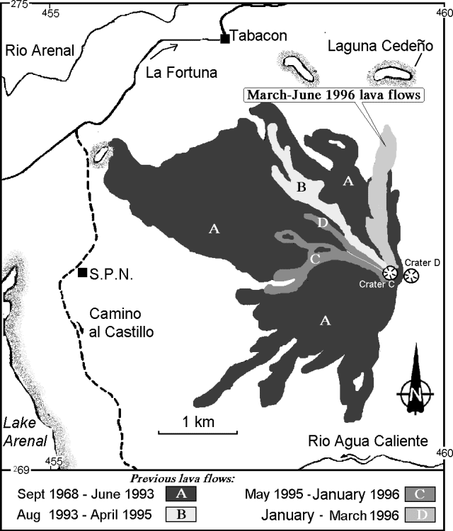 |
Figure 77. Sketch map of Arenal and vicinity showing distribution of major lava flows, 1968-96. Courtesy of G. Soto (ICE). |
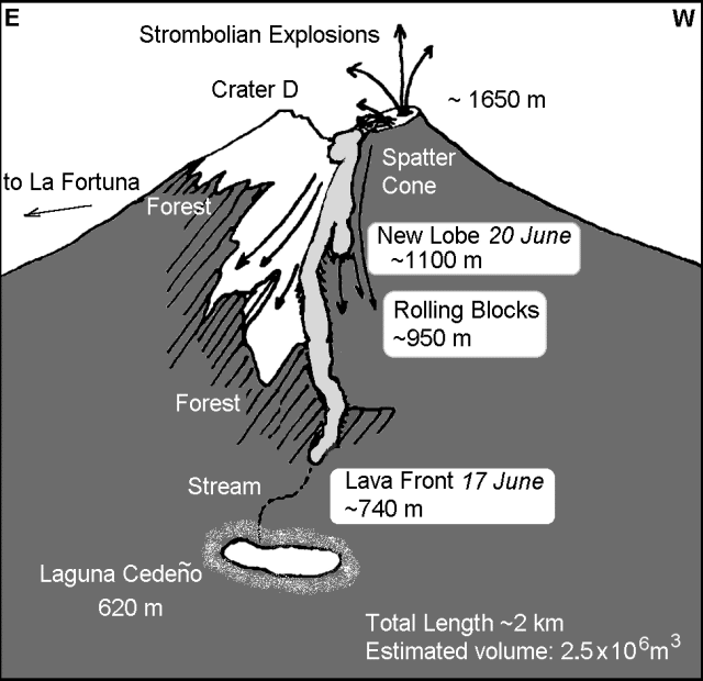 |
Figure 78. Sketch of Arenal in an oblique view from the N flank, mid-June 1996. Courtesy of G. Soto and F. Arias (ICE). |
Table 16. The mass of Arenal's ash accumulating per day (collected 1.8 km W of the active vent). Courtesy of ICE.
| Collection Interval | Avg daily ashfall (grams/m2) | Ash % 300+µ | Ash % less than 300µ |
| 22 Dec-06 Mar 1996 | 33 | 50 | 50 |
| 06 Mar-15 Apr 1996 | 43 | 50 | 50 |
| 15 Apr-16 May 1996 | 48 | 56 | 44 |
| 16 May-20 Jun 1996 | 58 | 20 | 70 |
OVSCICORI-UNA reported that during June low-frequency (<3.5 HZ) seismicity totalled 781 events; the majority of these events were associated with eruptions; some events were also recorded at a station 30 km SW of the active crater. Tremor durations of over 23 hours took place on 4, 6, 7, and 11 June; the total for the month was 375 hours. This tremor's dominant frequency was 2.1-3.4 hz.
Information Contacts: Erick Fernández, Elicer Duarte, Vilma Barboza, Rodolfo Van der Laat, and Enrique Hernandez, Observatorio Vulcanológico y Sismológico de Costa Rica, Universidad Nacional (OVSICORI-UNA), Apartado 86-3000, Heredia, Costa Rica; Gerardo J. Soto, Guillermo E. Alvarado, and Francisco (Chico) Arias, Oficina de Sismología y Vulcanología, Departamento de Geología, Instituto Costarricense de Electricidad (ICE), Apartado 10032-1000, San José, Costa Rica.
Lava continues to flow N
During July and August the lava flow on Arenal's N flank continued to extrude, descending to 760-800 m elevation. Near the end of August a second lobe running just W of the previous one became well developed. Blocks falling off the older flow's front continued to tumble E, burning vegetated areas. The small spatter cone near the vent (BGVN 21:06) disappeared.
Average daily ashfall 1.8 km W of the active vents (table 17) was higher during May and June than earlier in the year (>50 grams/m2), but then decreased somwhat in July.
Table 17. Ash collected 1.8 km W of Arenal's active vent; note the corrected grain size of 300 µm (rather than 250 µm) also applies to tabled data in previous reports. Courtesy of Gerardo Soto, ICE.
| Collection Interval | Avg daily ashfall (grams/m2) | Ash % 300+µ | Ash % less than 300µ |
| May 1996 | 53 | 45 | 55 |
| Jun 1996 | 51 | 38 | 63 |
| Jul 1996 | 38 | 53 | 47 |
Eruptive activity during July appeared to decrease, but then in August appeared to again increase in terms of the amount and size of pyroclastic materials ejected. Some August eruptions vibrated the glass in houses 6.5 km E of the volcano and plumes from some of these eruptions rose up to 1 km above Crater C. On the morning of 29 August the volcano generated a small pyroclastic flow that traveled down the SE flank. During July, acidic rainfall most affected the NW, W, and SW flanks; during August, it affected the NE, E, and SE flanks. These acidic rains scalded the leaves of some plants.
Low-frequency earthquakes (table 18 and figure 79) often coincided with intervals of Strombolian eruptions. The days with the greatest numbers of eruptions were in the middle of the month; for example, 12, 14, and 18 July eruptions totalled 52, 55, and 59, respectively. July tremor (table 18 and figure 79), which was in the 2.1-3.4 Hz frequency range, took place for a total of 345 hours. For comparison, there were 420 hours in January 1996, the longest duration seen in the past two years; in 1994 many months had less than 100 hours of tremor. On seven days during July, tremor had durations of 15-18 hours; only one day had a duration of less than 5 hours.
Table 18. Average seismicity at Arenal, March-August 1996, as recorded 3.5 km E of the active vent (Fortuna station). Courtesy of ICE.
| Month | Earthquakes/day | Daily tremor (hours) |
| Mar 1996 | 47 | 5.6 |
| Apr 1996 | 63 | 7.8 |
| May 1996 | 68 | 7.8 |
| Jun 1996 | 79 | 8.3 |
| Jul 1996 | 67 | 5.9 |
| Aug 1996 | 65 | 6.6 |
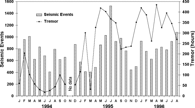 |
Figure 79. Arenal seismicity for 1994-August 1996 as registered at station VACR, 2.7 km NE of the active crater. There was no data in March 1994; five other months (June and December 1994 and December, February, and March 1995) had incomplete data. Consequently, the sums for these six months were scaled up and plotted assuming the rate of generated events during those months remained constant. Courtesy of OVSICORI-UNA. |
Although prior to 1995 measurements along the distance network generally indicated deflation, from the end of 1995 through an unspecified date in 1996 surveys to two stations found 7 µrad of accumulated inflation. Other stations remained relatively stable. During July 1996 a continued contraction was seen amounting to 22 ppm/year on average.
Arenal's first historical eruption, in 1968, began an unbroken sequence of Strombolian explosions and basaltic andesite discharges from multiple vents. The volcano has been watched by many tourists from a mountain lodge 2.8 km S of the vent that enables visitors to hear, to see, and occasionally to smell its dynamism.
Information Contacts: E. Fernández, E. Duarte, V. Barboza, R. Van der Laat, E. Hernandez, M. Martinez, and R. Sáenz, Observatorio Vulcanológico y Sismológico de Costa Rica, Universidad Nacional (OVSICORI-UNA), Apartado 86-3000, Heredia, Costa Rica; G.J. Soto and J.F. Arias, Oficina de Sismología y Vulcanología del Arenal y Miravalles: OSIVAM, Instituto Costarricense de Electricidad (ICE), Apartado 10032-1000, San José, Costa Rica.
Small pyroclastic flows
Some small pyroclastic flows took place in September but eruptions were milder than the previous month. Eruptions were often separated by 10-60 minute intervals, and plumes seldom rose much over 1 km. During September, a new lava flow began moving toward the crater's SW side.
Noteworthy eruptions took place several times during September. An eruption at 0926 on the 11th generated a pyroclastic flow that traveled SW; the associated plume reached 1,230 m altitude. At 1700 on the 29th eyewitnesses saw a rockslide off a lava flow that led to a small avalanche (figure 80). Also, at 1720 that same day, an ash-column collapse produced a small pyroclastic flow (figure 80). At 1634 on the 30th a pyroclastic flow swept NW; the associated plume reached 1,000 m altitude.
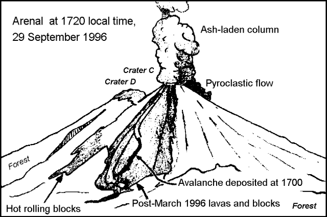 |
Figure 80. Arenal seen from the NNW looking towards the active flow field (shaded). The sketch shows events visible at 1720 on 29 September 1996: (A) the avalanche deposit laid down ~20 minutes earlier, and (B) the ash-laden column collapsing to create a small pyroclastic flow. Courtesy of G.J. Soto, ICE. |
During September, OVSICORI-UNA reported about average monthly seismic activity: 875 events and 300 hours of tremor (station VACR, 2.7 km NE of Crater C). ICE reported above-average seismic activity during September: 86 events and 4.78 hours of tremor (Fortuna Station, 3.5 km E of Crater C). OVSICORI-UNA noted that many of the seismic events were associated with Strombolian eruptions.
Although the volcano's distance network has generally shown a cumulative contraction since the initial measurements in 1991, a small pulse of inflation (reaching 5 ppm) took place in April 1996. Due to accumulating lava and pyroclastic materials, the summit of the active crater (C) grew 1.65 m between April and September 1996. This growth rate was consistent with the average rate of 4.13 m/year seen thus far in 1996 and close to the overall average of 5.33 m/year.
Arenal's post-1968 Strombolian-type eruptions have produced basaltic-andesite tephra and lavas. The volcano lies directly adjacent to Lake Arenal, a dammed reservoir for generating hydroelectric power.
Information Contacts: E. Fernández, E. Duarte, V. Barboza, R. Van der Laat, E. Hernandez, M. Martinez, and R. Sáenz, Observatorio Vulcanológico y Sismológico de Costa Rica, Universidad Nacional (OVSICORI-UNA), Apartado 86-3000, Heredia, Costa Rica; G.J. Soto and J.F. Arias, Oficina de Sismología y Vulcanología del Arenal y Miravalles (OSIVAM), Instituto Costarricense de Electricidad (ICE), Apartado 10032-1000, San José, Costa Rica.
Ongoing vigorous eruptions the subject of visits, reports, and concerns
During late 1996, Arenal's ongoing Strombolian eruptions continued. OVSICORI-UNA noted that late-1996 avalanches had traveled down the N and SW flanks. For example, one at 1109 on 11 December traveled down the N flank to ~1,300 m elevation. Acidic rainfall also continued to damage vegetation.
Some noteworthy September eruptions and their associated pyroclastic flows were mentioned in BGVN 21:09. Others also occurred late in 1996; one at 0926 on 11 December reached a point on the SW flank at 1,230 m elevation. Another pyroclastic flow occurred at 1630 on 30 December reaching 1,000 m elevation.
Observations during 19-24 November. Multiple pyroclastic flows with distinct pulses were reported by Steve O'Meara, Tippy D'Auria, and Robert Benward who watched Arenal for much of five days (19-24 November 1996) from 3.8 km due N of the summit (location determined by GPS); they found it very active with eruptions occurring intermittently from five distinct vents. The group noted long-duration fountaining and jetting; on 20 November these processes were continuous for over 30 minutes. The group saw multiple eruptions discharging plumes to heights >1 km, observed ashfall, and heard window-rattling explosion noises. They watched an advancing incandescent summit lava flow lobe whose front frequently calved off and produced spectacular incandescent rockfalls and avalanches. Also, they witnessed tumbling boulders and noted periodically strong snorting and huffing noises at the summit vents associated with the escape of incandescent gas.
Sheared from the lava flow front, some of the boulders were easily the size of small cars. As the boulders fell they made audible impact bursts and broke into smaller pieces as they rolled and bounced down the mountain (sometimes reaching the 700-m elevation). The scene of the falling and breaking boulders looked similar to a fireworks display.
The source of the lava lobe appeared to be the new spatter cone on the N side of Crater C, which the flow all but encompassed. The main lobe branched into three separate ones, each a source of rock falls. A lava lobe also appeared to be moving E into the saddle between craters C and D. A new lobe was moving down Crater C's NW side.
The source of the pyroclastic flows was unclear to the group, though they thought it might be the new spatter cone. On video footage some of the pyroclastic flows were very distinct. Many of the flows were also accompanied by a sluggish, reddish, small ash eruption from what appears to be one of the five vents, though these eruptions could also have issued from the spatter cone. Pyroclastic flows traveled 100-1000 m from the summit, but stayed within well-defined channels on the W side of the latest 1996 lava flow. O'Meara was somewhat concerned to encounter an active campsite at Laguna Cedeño--right in the path of some of the pyroclastic flows--and only 2 km from the summit.
Table 19 shows a sample of some of the kinds of observations recorded during the O'Meara group's stay. During their visit they also considered the positions of the sun and moon. The group suggested that the largest eruptions may have had a possible correlation to moon phase and tidal pulls as well as moon rise and set times. It appeared that the more violent eruptions of Vent 1 occurred at intervals of 6.5 hours. Using that hypothesis, the group claimed to have successfully and confidently estimated vent 1's major blasts to within 2 minutes of the events.
Table 19. A sample of the field notes, from 20 November 1996, describing Arenal activity during the O'Meara group's 5-day visit (complete observations available upon request). Courtesy of Steven O'Meara, Tippy D'Auria, and Robert Benward.
| Time | Observations |
| 1206 | Eruption; vent 2. |
| 1258 | Vents degassing. |
| 0108 | Vent 5 eruption with possible pyroclastic flow. |
| 0113-0118 | Small eruptions with sustained jetting combined with summit glow; jetting episodes appear to trigger lava flow surges. |
| 0149 | More degassing and summit glow. |
| 0215-0245 | Large eruption with continuous fountaining-jetting activity for 30 minutes; several bursts of intense activity (particularly vents 1 and 4, with a single blast from vent 2). |
| 0255 | A medium eruption from twin vents; 30 seconds later a small emission at vent 4. |
| 0252 | Degassing. |
| 0328 | Small explosion. |
| 0333 | Huffing noise at vent 2; D'Aurria likens it to the snorting of a bull getting ready to charge. |
| 0338 | Large discharge of blocks from vent 2 accompanied by snorting noises. |
| 0339 | Vents 3 and 4 spitting. |
| 0345 | Medium eruption from the center vent; heavy huffing; lots of gas escaping and boulders rolling from northerly flow. |
| 0416 | Explosion followed by degassing. |
| 0442 | Vent 4 spattering. |
| 0448 | Vent 2, small amounts of spattering. |
| 0450 | Vent 1, small silent eruption. |
| 0451 | Vent 1, larger and louder eruption. |
| 0454 | Medium-to-strong eruption noted from three different vents creating a large pyroclastic flow and discharging several large lava fragments. Saw the new lava flow area in the vicinity of vent 1, W of the large block lava flow. |
| 0509 | Medium eruption from center vent. |
| 1000 | Big explosions and noise. |
| 1036 | Big explosion and noise. |
| 1045 | Small eruption and big noise. |
| 1110 | Small eruption of reddish color observed from the settlement of Tabacón. |
Behavior at the five vents during the group's visit were as follows. Vents 1 and 3 were twin summit vents that appeared to be centered in Crater C. Vent 1 was the stronger of the two when they erupted separately. Both sent plumes vertically and produced prolonged roars and blasts.
Vent 2, located on the E side of Crater C, was the strongest and loudest, producing most of the house- and window-shaking eruptions. Many times the ejecta would blow out of this vent at a 45° angle toward Crater D. Sometimes, E- and N-arcing ejecta fell about a quarter of the way down the volcano's slope. This vent may have been the eastern lava lobe's source.
Vent 4 was centered on the new summit spatter cone N of Crater C. The vent ejected occasional spatter, though some long-enduring fountaining-degassing episodes also took place. Whereas vent 4 had been active when the group arrived, it was almost inactive by 22 November, though the lava flow around it continued to advance.
Vent 5, on the W side of the summit, produced very strong ash eruptions, but these events were mostly associated with muffled blasts at the observation site. Variously directed eruptions sometimes sent ejecta E, at a 45° angle toward the W, and at other times vertically.
Seismic data, recent reports, and a hazards caution. During September and November OVSICORI-UNA noted that both tremor and earthquakes were common, though not in unusual abundance (tremor duration, 300 and 237 hours; number of earthquakes, 875 and 471; respectively). Earthquakes were more abundant during October, a month when 1,094 registered, more than at any time during 1996. At the OVSICORI-UNA station, tremor duration in the previous months of 1996 had ranged between 261 and 434 hours; during October it was also moderately high (381 hours).
Some Arenal reports and abstracts that may not appear in typical European and North American literature indexes have come out recently. Five technical reports on Arenal appeared in a volume in November 1996 (ICE, 1996). The reports include discussions of 1) the volcano's behavior during the year 1993, 2) the spectral character of seismic signals and the P-wave velocity in the upper part of the edifice, 3) possible eruptions in 1915 and 1922, 4) the hazards, costs, and hazard perceptions associated with a moderate eruption, and 5) how meta-igneous, granulite facies xenoliths in Arenal lavas could provide evidence for a mafic basement. In addition, at least one of about 50 papers at a recent conference in Perú discussed hazards from Arenal (Laurent, 1996).
As a caution to people visiting or acting as guides at the popular volcano it should be noted that Melson and others (1997) have looked at the frequency of eruptions in a sample of over 196 days between 1987 and 1994. They found that hazardous pyroclastic eruptions occurred at wide-ranging intervals, from as little as a minute to over a day apart. However, 96% had a recurrence interval of <100 minutes. During these eruptions, ballistic blocks and bombs and infrequent pyroclastic flows posed the greatest hazards.
References. ICE Boletín, 1996, año 6, no. 11-12, Dirección de Ingeniería Civil, Departamento de Ingeniería Geológica, 78 p.
Laurent, K., 1996, Impacto de los desastres ocasionados por los volcanes Arenal e Irazú sobre la infraestructura energética de Costa Rica y medidas actuales para mitigar sus efectos: El Segundo Seminario Latinamericano "Volcanes, Sismos Y Prevencion" en Lima-Arequipa, Perú, del 4 al 9 de noviembre de 1996, J-C Thouret (coodinator), 178 p.
Melson, W.G., O'Hearn, T., Funk, V., Barquero, J., Barboza, V., Saenz, R., Fernandez, E., McNutt, S., and Benoit, J., 1997, Probabilistic volcanic hazard assessment, Arenal volcano, Costa Rica, 1987-95: unpublished report, Smithsonian Institution, Washington DC, U.S.A., 10 p.
Information Contacts: E. Fernández, E. Duarte, V. Barboza, R. Van der Laat, E. Hernandez, M. Martinez, and R. Sáenz, Observatorio Vulcanológico y Sismológico de Costa Rica, Universidad Nacional (OVSICORI-UNA), Apartado 86-3000, Heredia, Costa Rica; G.J. Soto and J.F. Arias, Oficina de Sismología y Vulcanología del Arenal y Miravalles (OSIVAM), Instituto Costarricense de Electricidad (ICE), Apartado 10032-1000, San José, Costa Rica; Steven O'Meara, PO Box 218, Volcano, HI 96785, USA.
Explosions diminished in January but continued through March
During January explosive activity diminished with respect to December 1996 in terms of both the number of eruptions and the quantity of ejected tephra. A S-flank avalanche on 1 January descended to ~1,000 m elevation. On the night of 14 January, a NE-flank pyroclastic flow traveled down to 800 m elevation, scalding vegetation. During February eruptive activity dropped yet lower, and in March, lower still. Despite these decreases, an incandescent avalanche was noted on 27 February at 1600. In addition, during the last week of that month the number of eruptions increased. March ash columns rose <1 km above Crater C. Crater D remained fumarolically active.
During January and February the lava flow on the N flank became active at 950 m elevation. During March, the N-flank flow maintained activity down to 800 m elevation and a new flow began, its path following the previous flow's channel and its front reaching 1,300 m elevation. Cold rock avalanches took place down local drainages (e.g. Calle de Arenas, Gillermina, and Rio Caliente).
Tremor duration peaked in April and June 1996 at around 400 hours/month; thereafter tremor typically remained at ~200-300 hours/month (figure 81). The number of earthquakes peaked in middle to late 1996 (figure 81). Surveys of the distance array revealed that between November 1996 and January 1997 the relative positions of survey stations contracted by an average of 4-5 ppm/month. In March it was reported that the average contraction seen in recent years (~27 ppm) continued along the radial lines on the volcano's W, SW, and S flanks. A dry-tilt station at the base of the volcano typically has small measured tilts amounting to 7-10 µrad/year.
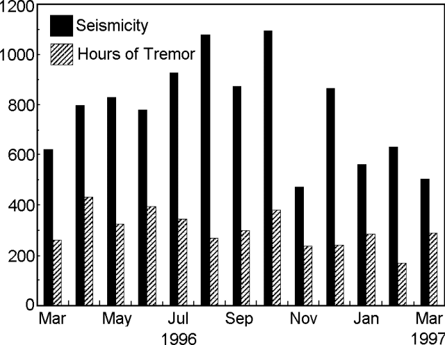 |
Figure 81. Arenal seismicity and tremor recorded during March 1996 through March 1997 (registered at station "VACR," 2.7 km NE of the main crater). Courtesy of OVSICORI-UNA. |
The vegetation that had begun to regrow on the NE, E, and SE flanks continued to be affected by acid rain. Some species displayed burns on the edges and tops of leaves, while others showed signs of discolored leaves.
Information Contacts: E. Fernández, E. Duarte, V. Barboza, R. Van der Laat, E. Hernandez, M. Martinez, and R. Sáenz, Observatorio Vulcanológico y Sismológico de Costa Rica, Universidad Nacional (OVSICORI-UNA), Apartado 86, 3000 Heredia, Costa Rica.
New pyroclastic cone noted in May
During April OVSICORI-UNA scientists noted a decrease in eruptive vigor and seismicity at Arenal compared to the previous month. Lavas erupted beginning in January 1997 advanced during April to reach an elevation of ~800 m on the N flank; lavas erupted in March advanced during April to reach an elevation of 1,150 m. During mid-May some advancing lava fronts had reached an elevation of about 1000 m. As has been typical during recent years, Crater D showed only fumarolic activity. Crater C erupted about 288 times during May.
Tremor occurred for as much as 15 hours/day during April, but both tremor and earthquake counts dropped by about a third compared to March, and further still during May. Nonetheless, on 16 May there were 8 hours of continuous tremor (amplitude, 18 mm; dominant frequency, 2.0-3.9 Hz). This tremor accompanied venting of new lava that traveled down the NNW flank. At least through April, the OVSICORI-UNA distance network continued to undergo radial contraction of ~22 ppm/year.
During 10-14 May, Gerardo Soto saw mild Strombolian eruptions tens of minutes apart, with ash columns up to 500 m above the crater. Although this seemed comparatively quiet, the usual vigorous summit fumarolic outgassing prevailed. A new pyroclastic cone was noted in Crater C (figure 82); it stood tens of meters high. Although the volcano lacked pyroclastic flows while he was watching, well developed pyroclastic-flow fans existed on the N and W flanks and summit.
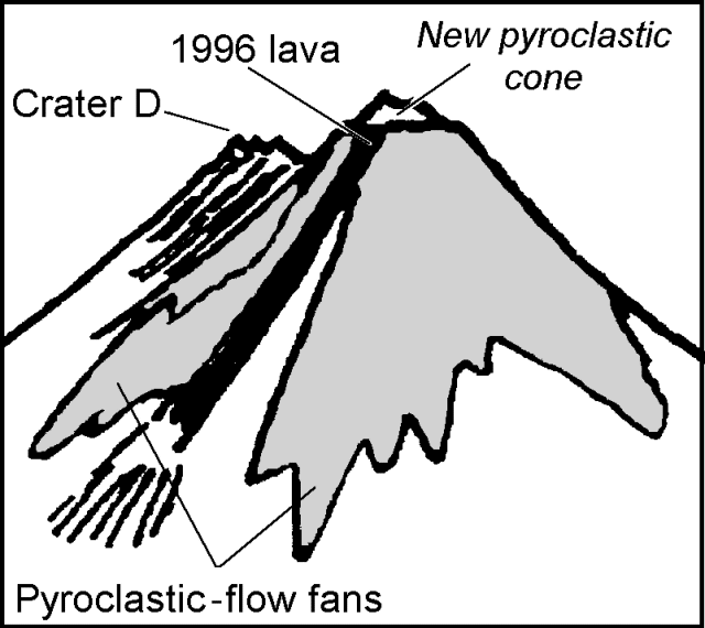 |
Figure 82. A rough sketch of Arenal as seen from the NW during 10-14 May 1997. Courtesy of Gerardo Soto, ICE. |
Arenal's first chronicled eruption, in 1968, began an unbroken sequence of Strombolian explosions and basaltic andesite discharges from multiple vents. The volcano can be seen from a lodge 2.8 km S of the vent that enables visitors to hear, to see, and occasionally to smell its dynamism.
Information Contacts: E. Fernandez, R. Van der Laat, F. de Obaldia, T. Marino, V. Barboza, W. Jimenez, R. Saenz, E. Duarte, M. Martinez, E. Hernandez, and F. Vega, Observatorio Vulcanologico y Sismologico de Costa Rica, Universidad Nacional (OVSICORI-UNA), Apartado 86-3000, Heredia, Costa Rica; G.J. Soto, Oficina de Sismologia y Vulcanologia del Arenal y Miravalles (OSIVAM), Instituto Costarricense de Electricidad (ICE), Apartado 10032-1000, San José, Costa Rica.
June-September behavior and summary of 1992-96 lava output
Since the last report of activity through May (BGVN 22:05), and through September, seismic and explosive pyroclastic activity remained vigorous. Blocky lavas continued to emerge from the active summit crater, Crater C, although a minor pause took place. Crater C continued to aggrade as lava and pyroclastic deposits accumulated on its floor. An estimate during June put the aggradation rate at ~1 m/month.
The passing of a tropical storm during June brought a shift in winds and caused ashfall at Fortuna, a settlement ~6.5 km E of the summit. N-flank lavas emitted in May traveled NW. During June these lavas advanced down to the 1,100-m elevation, and during July to 850 m. Around noon on 23 June incandescent avalanches descended the N flank to 850 m elevation. Associated ash blew W.
During August newly erupted lavas were absent, though pyroclastic flows were frequent. One, on 19 August, traveled S and another, on 20 August, was heard heading NW for a duration of 50 seconds. August also brought acidic rain and rain-triggered mass wasting. On 5 and 7 September observers noticed W-flank avalanches that traveled downslope to the 950-m elevation. In their upper reaches, these avalanches carved a small notch in the crater's western border. During the last week of September escaping lavas followed this avalanche track to 1,450 m elevation.
Survey of the distance network during June disclosed a monthly contraction of 2-4 ppm. This change was consistent with that seen over the past four years.
During the last week of June, seismic signals had variable amplitudes, periods of under 3 Hz, and continued unbroken for durations up to 400 seconds. These signals accompanied puffing and the expulsion of gas and ash. The same seismic signals repeated again in July but these had even longer unbroken durations of up to 800 seconds.
Unusually vigorous seismicity during the first half of June included an explosion detected at OVSICORI- UNA seismic stations over 150 km away. Such a seismically energetic explosion had not occurred during the past 3 years.
Gerardo Soto (OSIVAM) noted that many Arenal eruptions were relatively mild and quiet "mute events" that sent ash clouds to 0.5-km altitudes. During July, explosions occurred every half hour, whereas during early August, they occurred every ten minutes or less. Soto also confirmed the above-mentioned absence of NNW-flank lavas escaping in late August. OSIVAM found that temperatures and acidity in the springs around Arenal had remained stable.
The OSIVAM seismic system (at Fortuna Station, 3.5 km E of Crater C) measured the average numbers of earthquakes and hours of tremor/day (table 20). During this interval, 78 earthquakes/day occurred on average, about one every 18 minutes. Tremor prevailed ~34% of the time.
Table 20. Daily averages for earthquakes and tremor duration registered by OSIVAM, January-June 1997. Courtesy of G. Soto.
| Month | Earthquakes/day | Daily tremor (hours) |
| Jan 1997 | 62 | 10.5 |
| Feb 1997 | 91 | 7.3 |
| Mar 1997 | 73 | 10.8 |
| Apr 1997 | 88 | 8.5 |
| May 1997 | 68 | 6.7 |
| Jun 1997 | 84 | 6.8 |
| Average | 78 | 8.1 |
Soto also noted that during July, lava flows issued from the same vent high on the N slope that fed lava during the past year. Finally, Soto presented annual estimates on the rates and volumes of erupted products from Arenal during 1992-96 (table 21).
Table 21. Volume and rate of lava effusion at Arenal, 1992-96 (Soto, in press).
| Year | Volume (million m3) | Rate (m3/s) |
| 1992 | 7.8 | 0.25 |
| 1993 | 11.1 | 0.35 |
| 1994 | 12.3 | 0.39 |
| 1995 | 9 | 0.29 |
| 1996 | 10 | 0.32 |
| Average | 10.0 | 0.32 |
References. Soto, G.J., 1996, La actividad del volcán Arenal durante 1995: Boletín OSIVAM, San José, Costa Rica, v. 8, no. 15-16, p. 56-61.
Soto, G.J., in press, La actividad del volcán Arenal durante 1996: Boletín OSIVAM, San José, Costa Rica, v. 9, no. 17-18.
Information Contacts: E. Fernandez, R. Van der Laat, F. de Obaldia, T. Marino, V. Barboza, W. Jimenez, R. Saenz, E. Duarte, M. Martinez, E. Hernandez, and F. Vega, Observatorio Vulcanologico y Sismologico de Costa Rica, Universidad Nacional (OVSICORI-UNA), Apartado 86-3000, Heredia, Costa Rica; G.J. Soto, Oficina de Sismologia y Vulcanologia del Arenal y Miravalles (OSIVAM), Instituto Costarricense de Electricidad (ICE), Apartado 10032-1000, San José, Costa Rica.
January-November tremor and earthquakes
Seismicity for Arenal during January through November 1997 is shown on figure 83. The monthly earthquake count peaked in July at around 1,600 events, but many months had fewer than 600. Tremor reached durations of 250-300 hours during January, March, and June.
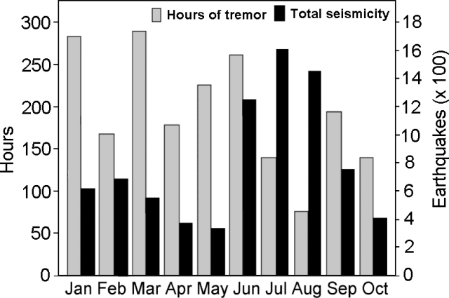 |
Figure 83. Arenal's monthly earthquake count and tremor duration for the interval January-October 1997. Data were registered at station "VACR," 2.7 km NE of the main crater. Courtesy of OVSICORI-UNA |
Arenal's first historical eruption, in mid-1968, began an unbroken sequence of Strombolian explosions and lava effusion from multiple vents. Since then the volcano has erupted material of basaltic-andesite composition.
Information Contacts: E. Fernandez, R. Van der Laat, F. de Obaldia, T. Marino, V. Barboza, W. Jimenez, R. Saenz, E. Duarte, M. Martinez, E. Hernandez, and F. Vega, Observatorio Vulcanologico y Sismologico de Costa Rica, Universidad Nacional (OVSICORI-UNA), Apartado 86-3000, Heredia, Costa Rica.
Relatively quiet in December but lavas still venting in March
During December [1997], lavas emitted beginning in September continued to flow down Arenal's W flank. They reached 1,400 m elevation and mass wasting carried some material to as low as 1,000 m elevation. December eruptive rates and intensities were low; also, the number of earthquakes and hours of tremor were both at or near the minimum values seen during the course of the year. This pattern continued into January 1998. Still, on infrequent occasions the active crater (Crater C) discharged plumes reaching at least 1 km in height above the crater.
Lavas vented in late January continued to flow in February, descending to 1,100 m elevation, and branching near 1,300 m elevation to form a new arm directed to the NW down the Tabacón river valley. During March, this new arm flowed down to reach 1,200 m elevation; the main channel extended to 1,000 m elevation; another arm branched off to the W at 1,400 m elevation and descended about 100 m.
Observers noted two pyroclastic flows during January-February. The first reached 1,100 m elevation on the SE flank. The second followed a similar path and reached 900 m elevation.
The number of low-frequency earthquakes (<4.0 Hz) during January and February, while still low, rose more than 25% over the number during December. The hours of tremor during January-February also remained low; during the latter month the dedicated seismic station (VACR) registered only 58 hours, the lowest monthly record in at least two years. During March, seismicity appeared to rise again, but the seismic system only functioned 18 days of the month. During this time the system recorded 80 hours of tremor.
OVSICORI-UNA scientists noted fumarolic activity in crater D as well as acid rain on the volcano's leeward flanks (towards the NW, W, and SE). In these sectors, some species of plants sustained visible leaf damage.
Information Contacts: E. Fernandez, V. Barboza, R. Van der Laat, R. Saenz, E. Duarte, E. Malavassi, T. Marino, M. Martinez, and E. Hernandez, Observatorio Vulcanologico y Sismologico de Costa Rica, Universidad Nacional (OVSICORI-UNA), Apartado 86-3000, Heredia, Costa Rica; Mauricio Mora Fernandez, Sección de Sismologia, Vulcanologia y Exploración Geofisica, Escuela Centroamericana de Geología, Universidad de Costa Rica, P.O. Box 35-2060, San José, Costa Rica.
Unusually energetic eruption on 5 May sends pyroclastic flows 2 km downslope
In the early afternoon of 5 May, Arenal, which typically issues Strombolian eruptions and lava flows, began discharging pyroclastic flows. Although pyroclastic flows have been common here in the past, rarely have so many repeatedly erupted over the course of hours. What follows integrates reports from OVSICORI-UNA and OSIVAM.
OVSICORI-UNA noted that few premonitory signs were apparent during April. Compared to March, April eruptive active appeared diminished in terms of the number of eruptions, their intensity, and the quantity of ejecta. During April lava flows traveling down the W flanks stood at about 1,250- and 1,450-m elevations, the latter flow having first vented at the beginning of April. Also during April a new lava flow directed NW reached 1,200 m elevation and a lava flow descended the N flank to 1,300 m elevation.
During April blocks on Crater C's NW wall broke loose and caused small avalanches. Only fumarolic emanations came from Crater D. During nine days of April when the OVSICORI-UNA seismic system operated, 93 events were registered, most associated with Strombolian eruptions and avalanches down the W and NW flanks. Tremor prevailed during this period for 86 hours. Histograms showing recent values for monthly earthquakes and tremor appeared in BGVN 22:11.
The strongest emissions on 5 May took place during about 1300-1500. During 1254-1900 OVSICORI-UNA estimated Arenal produced 23 pyroclastic flows. These flows traveled down the NNW flank (in the upper reaches of the Tabacón drainage basin) reaching 740 m elevation (dashed arrow, figure 84). OSIVAM also reported 23 pyroclastic flows, during the interval 1220-1800, which they designated block-and-ash flows. They noted that several of these flows occurred almost continuously during the first 30 minutes, followed by others separated by several minutes (i.e., events at 1305-1317, 1420, 1427-1435, 1440, 1450, 1510, 1516, 1530, 1547, and 1600). They also noted that the pyroclastic flows began after the partial collapse of the cone's NNW wall, a spot that contained an adjacent pool of pasty, near-solidus lava. The flows had maximum run-out distances of ~2 km; they reached velocities of ~60 km/hour, and their total volume reached perhaps 500,000 m3(about one-fourth the volume of 1993 pyroclastic flows; Soto and others, 1996). Clasts within the deposits were predominantly faceted blocks. In contrast, bulbous lava lumps constituted <5% of the observed deposit. OSIVAM suggested the former had come from the crust or cap of the lava pool, an observation in accord with the apparent partial collapse along the margin of the lava pool.
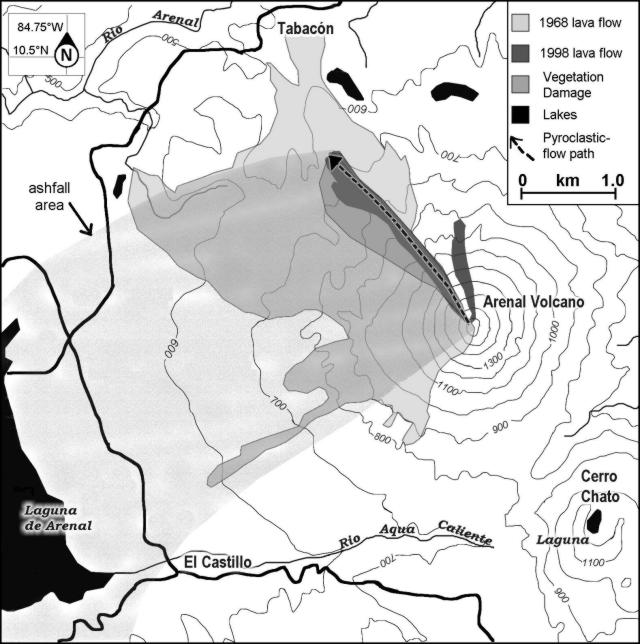 |
Figure 84. Map of Arenal and vicinity showing the situation just after the 5 May 1998 eruption. The 5 May pyroclastic flows swept NNW (dashed arrow); they burned vegetation, especially along their path's southwesterly fringe. Associated tephra fell on Arenal's W side. Courtesy of OVSICORI-UNA. |
Along the steepest pitches of the route of the pyroclastic flows (areas sloping 35-40°), they scoured a gully or channel that OVSICORI-UNA estimated had a maximum width of 100 m, a depth of ~10 m, and a length of ~1.6 km (figure 85). OSIVAM estimated the scoured channel as ~50 m in width, ~10-20 m in depth, and ~400 m in length. The feature was short-lived: during the night of 5 May new blocky lavas spilled from the source of the pyroclastic flows and began filling the channel.
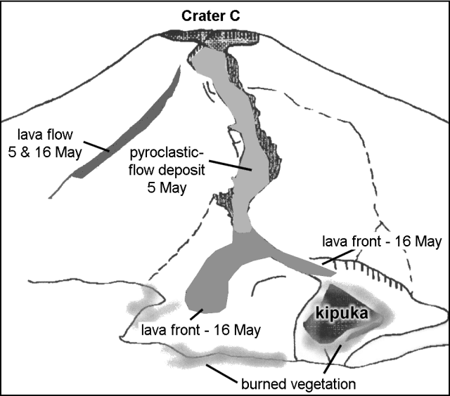 |
Figure 85. Sketch showing Arenal's NW to N flanks as seen on 6 and 16 May 1998 from Tabacón resort. Recent deposits on 6 May included the N-flank April lavas, and the 5 May pyroclastic-flow deposit with areas scorched and burned alongside it. Although not shown, by 16 May lavas covered the bulk of both the pyroclastic-flow deposit and the narrow channel scoured in the steep upper parts of the edifice; the distal ends of these lavas progressed downslope from the pyroclastic-flow deposits, forming the two branching lobes shown. One burned area seen on 6 May was a pre-existing kipuka (an area between lava flows that had continued to support vegetation). Courtesy of OVSICORI-UNA. |
OSIVAM's Fernando Alvarado witnessed the pyroclastic flows and took several dozen photographs. Inspection of these photographs suggested that some flows were relatively simple, containing a single front, and that they traveled only about 1 km. Other flows had two to three lobes moving at different velocities; they incorporated larger volumes of tephra and achieved longer runout distances.
The OSIVAM seismic system (six digital stations around Arenal) failed to detect any clear seismic event that triggered the initial collapse that led to the onset of pyroclastic flows. During the event, the seismic data disclosed small explosions, thought to be due to decompression of the lava pool during unloading.
OVSICORI-UNA reported that the pyroclastic flows left a deposit of bombs, blocks, and ash. Included blocks were semi-rounded and had abundant cooling joints; they often contained scoriaceous and bread-crust textures; their sizes ranged up to 1.5 x 3.5 x 4 m. These larger blocks appeared to float within a deposit of smaller blocks and sand-sized grains. At an undisclosed time of inspection the block's temperatures were as high as 525°C, whereas at 10-cm depth the smaller tephra of the deposit's matrix reached only 100°C.
Some vegetated areas adjacent to the pyroclastic deposits were scorched or burned (figures 84 and 85). The OVSICORI-UNA report described an older kipuka (figure 85) downslope of the terminal end of the flows, which was about 100 x 400 m across.
OVSICORI-UNA further reported that the 5 May eruption discharged ash clouds that rose to 1.5 km; portions of the ash cloud's base covered the NW, W, and SW flanks of the volcano. At 3 km from the vent, the maximum ash-fall deposit thicknesses were 2-5 mm. Ash fell on the community of Castillo, 7 km SW of Arenal and on the surface of the nearby reservoir Laguna de Arenal (figure 84). Ash plumes reached 35 km SW (Las Juntas de Abangares).
After 5 May, OVSICORI-UNA noted that emerging lava continued to follow the channel scoured by the pyroclastic flows. By 9 May lava had refilled a large part of the channel and the volcano returned to issuing more typical Strombolian eruptions. By 16 May extruded lava had filled the channel, progressed beyond its terminal end, and branched into two lobes (figure 85).
OVSICORI-UNA's Rodolfo Van der Laat noted that authorities and others responded rapidly; aviators were warned and asked to make special detours around the erupting plume. The 5 May events prompted authorities to raise the hazard status to "red alert." It turned out that the distal ends of the longest pyroclastic flows came to rest about 1.6 km from a lodge and hot-spring spa (Tabacón resort). In the Tabacón valley over 400 people were evacuated. Media reports included articles in "La Nacion" newspaper (in English by V. Murillo and G.Chaves and in Spanish by C. Hernandez and Adrian Meza). They described tourists intent on taking photos and reluctant to leave the hazardous area.
Background. Noteworthy pyroclastic flows at Arenal occurred both in 1968 (Sáenz and Melson, 1968) as well as in 1975 (Van der Bilt and others, 1975; Matumoto and Umaña, 1976), 1987, 1993 (Fernández and others, 1993, 1994), and again on 5 May 1998. Arenal's first historical eruption, in 1968, began an unbroken sequence of Strombolian explosions and basaltic andesite discharges from multiple vents. Pyroclastic flows have frequently accompanied eruptions. The 1968 explosive episode devastated the W flank and caused 78 deaths. Arenal's post-1968 Strombolian-type eruptions have produced basaltic-andesite tephra and lavas. The volcano has become a popular spot for tourists, and facilities near the volcano, including some on the now-vulnerable NW side, have recently grown in number.
References. Fernández, E., Barquero, J., Barboza, V., Van der Laat, R., Marino, T., and De Obaldía, F., 1993, Estado de los volcanes 1991: Boletín de Vulcanología, no. 22, p. 5-10.
Fernández, E., Barquero, J., Barboza, V., Van der Laat, R., Marino, T., and De Obaldía, F., 1994, Estado de los volcanes 1992: Boletín de Vulcanología, no. 23, p. 5-11.
Matumoto, T., and Umaña, J., 1976, Informe sobre la actividad del volcán Arenal ocurrida el 17 de junio de 1975: Revista Geofísica del Instituto Panamericano de Geografía e Historia 5, p. 299-315.
Sáenz, R., and Melson, W., 1968, La erupción del volcán Arenal, Costa Rica en julio de 1968, Revista Geográfica de América Central: Escuela de Geografía, Facultad de Ciencias de la Tierra y el Mar, Universidad Nacional, Heredia, Costa Rica, No. 5-6, p. 55-148.
Soto, G.J., Arias, F., Alvarado, G.E., Madrigal, L.A., and Barquero, R., 1996, Resumen de la actividad del Volcán Arenal durante 1993 (Summary of Arenal's volcanic activity during 1993): Bol. Obs. Vulc. Arenal 6 (11-12), San José, Costa Rica, p. 5-22.
Van der Bilt, H., Paniagua, S., and Avila, G., 1976, Informe sobre la actividad del volcán Arenal iniciada el 17 de junio de 1975: Revista Geofísica del Instituto Panamericano de Geografía e Historia 5, p. 295-298.
Information Contacts: R. Van der Laat, E. Fernandez, F. de Obaldia, T. Marino, V. Barboza, W. Jimenez, R. Saenz, E. Duarte, M. Martinez, E. Hernandez, and F. Vega, Observatorio Vulcanologico y Sismologico de Costa Rica, Universidad Nacional (OVSICORI-UNA), Apartado 86-3000, Heredia, Costa Rica; G.J. Soto, G.E. Alvarado, and W. D. Taylor, Oficina de Sismologia y Vulcanologia del Arenal y Miravalles (OSIVAM), Instituto Costarricense de Electricidad (ICE), Apartado 10032-1000, San José, Costa Rica; La Nacion, San José, Costa Rica (URL: http://www.nacion.co.cr/ln_ee/1998/mayo/06/english3.html).
A mild eruptive phase following the more energetic 5 May outburst
An unusually energetic eruption took place on 5 May, producing pyroclastic flows (BGVN 23:04), but the volcano returned to more passive behavior later in the month. OSIVAM produced a follow-up report devoted to the eruption, including some of Fernando Alvarado's photographs of the pyroclastic flows and brief comparisons and contrasts with somewhat similar events in 1975 and 1993 (Alvarado and others, 1998).
OVSICORI-UNA reported that a lava flow that began to be extruded in April trended N (see map, BGVN 23:04) and spawned avalanches in the early days of the month. This flow stopped at 1,100 m elevation a few days after the pyroclastic flows of 5 May. Another lava flow emerged soon after the pyroclastic flows and began descending along their channel (BGVN 23:04). On 26 May this lava flow ceased its advance with its front at 800 m elevation. The lava filled the channel's lower stretches. Excepting the 5 May event, the eruptive vigor was low in May and June both in terms of the quantity of pyroclastic material ejected and the height of the eruptive plume. During May, OVSICORI-UNA noted that plumes rarely ascended over 500 m above Crater C. As typical, Crater D fumaroles continued to emit gases.
A lava flow began extruding on 12 May; it went NW and its front eventually halted at 780 m elevation. Another such flow began in mid-June; at the end of the month it had reached 850 m elevation. During June it was noted that the NE, E, and SE flanks continued to receive ash falls and acidic rainfall. Also, on some parts of the edifice, cold avalanches have descended. These began on steep slopes, where areas of poorly consolidated alluvium and high amounts of rainfall have caused the vegetation to recede, leaving gullies that continue to widen and deepen.
The network of distance stations continue showing a general pattern of contraction. Dry tilt at the base of the volcano shows slow deflation. No significant changes were registered in relation with the activity (collapse of part of the summit wall and pyroclastic flows) of May 5th.
Reference. Alvarado, Guillermo E., Soto, Gerardo J., and Taylor, Waldo D., 1998, La Actividad del volcán Arenal (5 de Mayo de 1998) y sus implicaciones para la amenaza de las obras del ICE e infraestrutura cercana: Instituto Costarricense de Electricidad (ICELEC) Oficina de Sismología y Vulcanología (OSIVAM), Mayo de 1998, Informe OSV.98.04.ICE, 14 p.
Information Contacts: E. Fernandez, V. Barboza, E. Duarte, R. Saenz, E. Malavassi, M. Martinez, and Rodolfo Van der Laat, Observatorio Vulcanologico y Sismologico de Costa Rica, Universidad Nacional (OVSICORI-UNA), Apartado 86-3000, Heredia, Costa Rica; G.J. Soto, G.E. Alvarado, and W. D. Taylor, Oficina de Sismologia y Vulcanologia del Arenal y Miravalles (OSIVAM), Instituto Costarricense de Electricidad (ICE), Apartado 10032-1000, San José, Costa Rica.
Less vigorous eruptions but lava still escaping during July
Compared to recent months, during July both the number of eruptions and the quantity of material emitted decreased. The lava flow extruded in mid-June descended the NE flank and its front reached 800 m elevation. The lava flow branched at about 1,100 m elevation, forming a NW-trending arm who's front reached 850 m elevation.
Downwind rain samples collected during the dry season (January-April) often were both more acidic and higher in measured anions than those collected in the wetter intervals (figure 86). Although the seismic station was plagued by 10 days with transmission problems, during July the station registered 229 eruptions and 120 hours of tremor.
 |
Figure 86. Rainwater sampled downwind of Arenal, 9 January 1997 through 28 July 1998. Samples collected at station Cárava; error on the pH values was estimated at ± 0.05. Courtesy of OVSICORI-LAQAT. |
Information Contacts: E. Fernández, V. Barboza, M. Martinez, E. Duarte, R. Van der Laat, E. Hernández, and T. Marino, Observatorio Vulcanologico y Sismologico de Costa Rica, Universidad Nacional (OVSICORI-UNA), Apartado 86-3000, Heredia, Costa Rica.
Declining seismic amplitudes since late 1996
A seismic instrument at Arenal has registered declining seismicity since late 1996 (figure 87). The instrument resides at Arenal Observatory Lodge, 2.8 km S of the summit. This three-component instrument (a Marks Products L-4-3D seismometer) interfaced to an automatic data acquisition system has been in nearly continuous operation for several years. The automated system looked at the output during 19-second-long intervals. The plots show seismicity in terms of the monthly percentage of these intervals with maximum amplitudes over 0.1 mV. Each plot corresponds to one of the instrument's three orthogonal components. The vertical component had the lowest amplitudes with only a few percent of the intervals over the threshold, and those occurred mainly in 1995-96. The horizontal components behaved with broad-scale similarity; but the N-S component had more vigorous response, in late 1996 and 1997 over 20% of the intervals extended over the stated threshold.
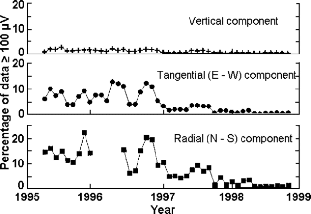 |
Figure 87. Arenal's monthly seismicity during early 1995-late 1998 as measured 2.8 km S of the summit. The vertical axis, scaled identically on all three components, shows the percent of intervals registered over the threshold of 100 microvolts. The missing interval on the N-S (radial) component reflects instrument malfunction. From late 1996 until the last reported data point in late 1998, all three components showed declining seismicity. Courtesy of William Melson and Sara James. |
At Arenal, seismic levels have typically correlated positively with the intensity of pyroclastic outbursts. Decreased seismic intensity has often correlated with the escape of lava flows without pyroclastic outbursts. In harmony with the seismic data, observers noted both escaping lavas and fewer pyroclastic outbursts during much of 1998.
Information Contacts: Jorge Barquero, Observatorio Vulcanológico y Sismológico de Costa Rica, Universidad Nacional (OVSICORI-UNA), Apartado 86-3000, Heredia, Costa Rica; William Melson and Sara James, Department of Mineral Sciences, Smithsonian Institution, Washington, DC 20560-0119 USA.
Eruptions increase in volume and number during February
This report covers August 1998 through March 1999. Early in this interval a small dome grew at a point adjacent and S of Crater C's lava vent; during September the dome reached ~10-m tall. Figure 88 shows Arenal's summit topography in April 1998.
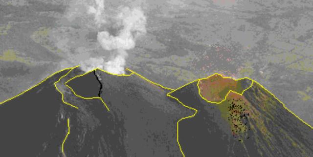 |
Figure 88. Oblique aerial photo of Arenal's summit taken looking to the N in April 1998. Crater D (right), last active in 1525, remains fumarolically active. Its rim formed the summit of the volcano prior to 1968. Crater C, the active crater, lies steaming on the left and contains a prominent breach on its rim. Lines on the photo were added to help distinguish key features. Although the exact date of the photo is unknown, it was taken shortly before the 5 May eruption. That eruption, which was unusually energetic, included pyroclastic flows, an airfall deposit, as well as the more typical lava flows. Photograph by Federico Chavarria Kopper; courtesy of Rodolfo Van der Laat, OVSICORI-UNA. |
The volume and number of explosive eruptions in April 1999 diminished with respect to February, continuing a trend of decreasing activity going back to late 1998. Lava pulses first emitted during December traveled down the N flank and during February made it to 1,200 m elevation. Others descended the NE flank; since April 1998 lavas traveling in other directions have been absent. During January through April ash columns rarely rose more than 500 m.
Also during January-April, EDM surveys detected a contraction of 20 ppm/year; tiltmeters measured a deflation of 7-10 µrad/year. Seismic data transmission problems plagued the local station (VACR) during August, September, March, and April. Seismically detected eruptions registered between 48 and 473 times a month. Tremor prevailed for between 25 and 120 hours a month.
Despite ongoing Strombolian eruptions venting adjacent to Arenal's summit at crater C during 1999, there occurred no measurable gain in summit height. Most pyroclastic material entered channels and descended the summit area. As is typical, crater D remained fumarolically active.
Acid rain most strongly affected the flanks on the NW, W, and SW. Rainwater chemistry collected at station Cáracava for January 1997 through September 1998 showed these variations: pH, 3.4- 4.5; SO4 ion, ~2-13 mg/L; Cl ion, ~3-27 mg/L. For both 1997-98, peaks in pH appeared during September; similarly, peaks in the two ions appeared in the first half of the year (during the months January-May). The chlorine ion in rainwater was enriched compared to rainwater collected at Poás, a case where degassing occurs though a substantial crater lake that is thought to absorb a large portion of the fumarolic HCl.
Information Contacts: E. Fernández, V. Barboza, M. Martinez, E. Duarte, R. Sáenz, E. Malavassi, R. Van der Laat, E. Hernández, and T. Marino, Observatorio Vulcanologico y Sismologico de Costa Rica, Universidad Nacional (OVSICORI-UNA), Apartado 86-3000, Heredia, Costa Rica; Wendy Perez Fernandez, Seccion de Seismologia, Vulcanologia y Exploracion Geofisica, Escuela Centroamericana de Geologia, Universidad de Costa Rica, POB 35-2060, San José, Costa Rica.
Comparatively weak explosive activity during past 1.5 years
In November 1998-May 1999, Arenal's explosive activity continued, although at a reduced pace compared with past years. Crater C continued to emit gases, lava flows, and sporadic Strombolian eruptions. Fumarolic activity persisted at Crater D.
Information Contacts: E. Fernandez, V. Barboza, E. Duarte, R. Saenz, E. Malavassi, M. Martinez, and R. Van der Laat, T. Marino, and E. Hernandez, Observatorio Vulcanologico y Sismologico de Costa Rica, Universidad Nacional (OVSICORI-UNA), Apartado 86-3000, Heredia, Costa Rica; Wendy Perez Fernandez, Seccion de Seismologia, Vulcanologia y Exploracion Geofisica, Escuela Centroamericana de Geologia, Universidad de Costa Rica, POB 35-2060, San José, Costa Rica.
October 1999 pyroclastic flow amid 2 years of comparative quiet
Activity at Arenal since May 1999 (BGVN 24:06) has been comparatively quiet, a condition which has generally prevailed since an energetic outburst in May 1998 (BGVN 23:06), continued during July 1999 through January 2000. However, this relative quiet was broken in October 1999 by an anomalous pyroclastic flow, discussed below. Elevated activity occurred in November as well. In addition to lava flows traveling N and NE during this interval, in July a new, N-directed lava flow was emitted. Another during September traveled NE spawning occasional rockfalls off its front. Few eruptions produced plumes rising more than a kilometer above crater C, and crater D remained fumarolic in nature. Cold avalanches continued to occur down local valleys (including the Calle de Arenas, Manolo, Guillermina, and Agua Caliente). During June-August electronic distance measuring disclosed that the survey points underwent an average of 2 cm expansion.
A pyroclastic flow at 1721 on 26 October descended the W flank as far as the ~900 m contour and left an eroded swath. It was smaller and its path differed from the May 1998 pyroclastic flow down the N-NW flank along the Tabacón river (BGVN 23:04). In the 26 October event, fine tephra accumulated in an area ~200 m wide. This pyroclastic flow may have consisted of a series of several distinct events. The column height was ~1 km above the vent.
The 26 October event's precursors included heightened explosive activity and increased seismicity beginning on 8 October, and a decrease in tremor. A precursory seismic swarm may have also been related. Although high-frequency earthquake swarms are generally rare at Arenal, a modest one began in August 1999 and reached a maximum on 17 September (5 events per day). The swarm ceased after 1 October; it consisted of 55 registered events with 13 of these located. The earthquakes comprising the swarm had amplitudes below Mc 2.3. Hypocenters for the located earthquakes typically occurred at depths of 2-4 km. After the pyroclastic flow, the energy transmitted in explosions and the amplitude of tremors dropped considerably.
Information Contacts: E. Fernandez, E. Duarte, V. Barboza, R. Sáenz, E. Malavassi, R. Van der Laat, T. Marino, J. Barquero, and E. Hernández, Observatorio Vulcanologico y Sismologico de Costa Rica, Universidad Nacional (OVSICORI-UNA), Apartado 86-3000, Heredia, Costa Rica; M. Martinez and J. Valdez; Laboratorio de Quimica de la Atmosfera, Universidad Nacional; R. Barquero, Instituto Costarricense de Electricidad (I.C.E.), Departamento de Geologia, Apdo. 10032-1000, San José, Costa Rica; I. Arroyo and G. Alvarado, Observatorio Sismológico Vulcanológico Arenal y Miravalles (OSIVAM), Instituto Costarricense de Electricidad (ICE), Apartado 10032-1000, San José, Costa Rica.
Larger-than-average pyroclastic flow engulfs three people on 23 August
During January to July 2000 Arenal's outbursts generally remained low but included frequent pyroclastic explosions, gas emissions, and avalanches. In late August explosions spawned a pyroclastic flow that injured three people several kilometers from the crater; two later died. Three days later a small airplane crashed into the volcano.
In January through parts of June crater C continued its usual activities, consisting of a constant gas emission, sporadic Strombolian eruptions, and occasional incandescent avalanches. Crater D exhibited fumarolic activity. The lava continued to flow variously toward the NNE, E, SE flanks. The NE and SE flank were continually affected by acid rain and pyroclastic material that contributed to the destruction of the vegetation on these flanks, resulting in major erosion that created small avalanches on the rivers Calle de Arenas, Manolo, Guillermina, and Agua Caliente.
The EDM network (established along the subradial lines) continued to show an average annual contraction of 7-10 ppm. The dry inclinometers ("dry tilt") showed variations in the radial component, deflation at ~5 µrad per year.
During the last half of April and throughout May eruptive activity increased, but few ash columns rose to ~500 m over crater C. The columns of ash were carried by the predominating winds toward the NW and SE flank causing both acid rain and ash fall. In May a narrow channel of lava began to flow toward the NNE flank. It later widened into a fan burning vegetation on the N and NE flanks.
From April to May the seismometer detected an increase in both number of eruptions and the hours of tremor. On 16 May two MR 3 earthquakes were recorded and located on the flanks of the volcano at 2 and 5 km from the summit. These earthquakes were reported to be felt in La Fortuna, 6.5 km NE of the volcano.
Eruptive activity remained low in June; few eruption clouds rose more than 500 m over crater C. In July crater C continued with the emission of gases, lava flows, sporadic Strombolian eruptions, and occasional pyroclastic flows. The eruptive activity increased in July with respect to June, although the number of eruptions, their intensity, and the quantity of pyroclastic material ejected remained low.
In August Arenal became more active and underwent a series of explosions. One began at 0945 on 23 August; mutiple pyroclastic flows came down the volcano's NE side (figure 89) as a series of pulses. Pulses occurred at 0955, 0956, and 0958. The most important pulse occurred at 1001 and continued for six minutes. Two more pulses followed at 1008 and 1012. For the next two hours activity returned to normal, but at 1323 a new series of explosions began. At 1336 a pyroclastic flow began and lasted for ten minutes. Various pulses descended the NNE flank. Normal low-level activity resumed 19 hours after the afternoon explosions.
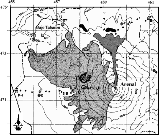 |
Figure 89. A map of Arenal and vicinity showing the distribution of deposits from the 23 August pyroclastic flows (N-directed swath of dark-gray color). The light gray shows the lava field formed by past eruptions. Courtesy of Rafael Barquero (OSIVAM). |
News reports. One of the pyroclastic flows on 23 August engulfed a Costa Rican tour guide and two tourists from the United States. OVSICORI-UNA stated that the victims were burnt by the front of the flow ~2.3 km from the crater. According to a local volcanologist, the flow was traveling at 80 km/hour at that point.
The three victims were sent to San José to be treated for their burns and injuries. On the night of 23 August the tour guide died in the hospital. An 8-year-old girl from Massachusetts died on 6 September as a result of her burns.
The National Emergency Commission (NEC) ordered evacuations of the tourist centers of Los Lagos, the Tabacón hot springs and resort, Hotel Montaña del Fuego, Arenal Lodge, and other areas. The NEC and Red Cross workers evacuated 600 tourists and residents and closed the route around the volcano to Tilarán. On 24 August the volcano returned to its normal behavior. The 23 August explosive eruptions were believed to be the strongest since the deadly 1968 eruption.
On 26 August a ten-passenger airplane crashed into the NE flank ~200 m below the summit. All of the occupants died. The cause of the crash is unknown at this point and no further details are available.
Information Contacts: Observatorio Vulcanologico y Sismologico de Costa Rica, Universidad Nacional (OVSICORI-UNA), Apartado 86-3000, Heredia, Costa Rica; Oficina de Sismología y Vulcanología del Arenal y Miravalles (OSIVAM), Instituto Costarricense de Electricidad (ICE), Apartado 10032-1000, San José, Costa Rica; The Tico Times (URL: http://www.ticotimes.net/); La Nacion (URL: http://www.nacion.co.cr/).
Maps, photos, and seismic data on the 23 August eruption
More details have emerged about the 23 August pyroclastic flows (BGVN 25:07) that cut a bold swath for several kilometers across the volcano's well-vegetated N flanks (figures 90 and 91).
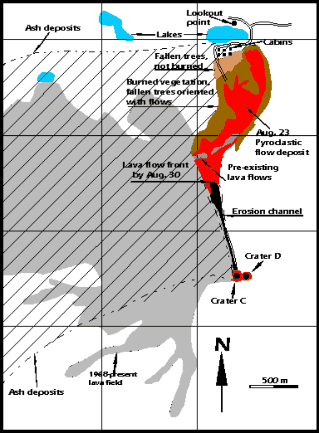 |
Figure 90. Sketch map of the area around Arenal showing the 23 August 2000 pyroclastic-flow deposit, including its various mapped zones, and showing the area of deposition for the associated ash fall over the NW quadrant. Beyond the distal end of the pyroclastic flows lies Cedeño lake. The other small lake ~1 km to the W is unnamed. The Tabacón river valley lies to Arenal's NW and crosses the region about a kilometer W of the unnamed lake. Courtesy of OVSICORI-UNA. |
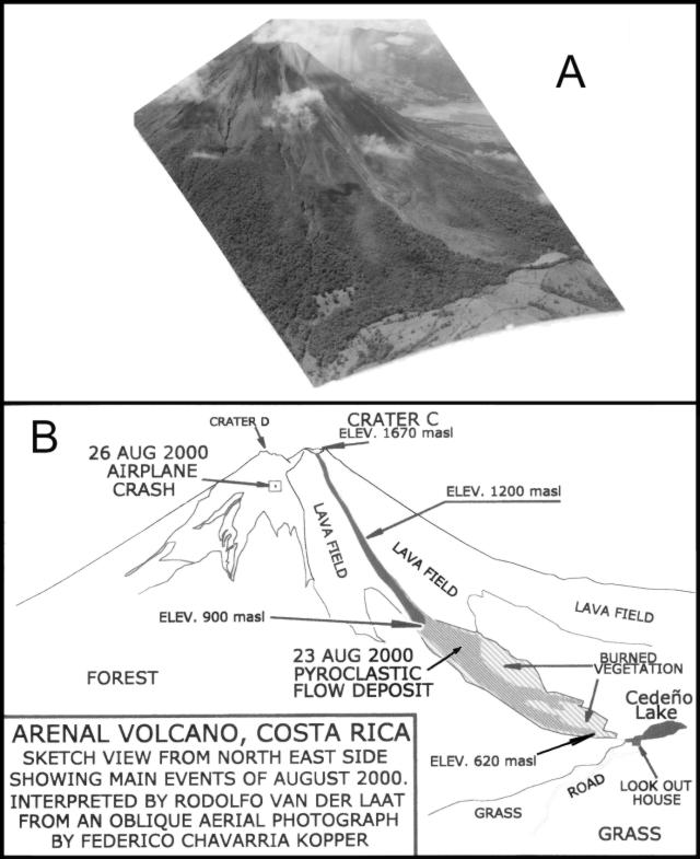 |
Figure 91. Oblique aerial photo taken around 0630 on 13 September 2000 by Federico Chavarria Kopper (A) showing the area of Arenal's NE flank ravaged by the 23 August pyroclastic flows. The large lake in the center-right background is Lake Arenal, a dammed reservoir that generates hydroelectric power. Interpretive diagram (B) identifying critical features on part A (prepared by Rodolfo Van der Laat, OVSICORI-UNA). |
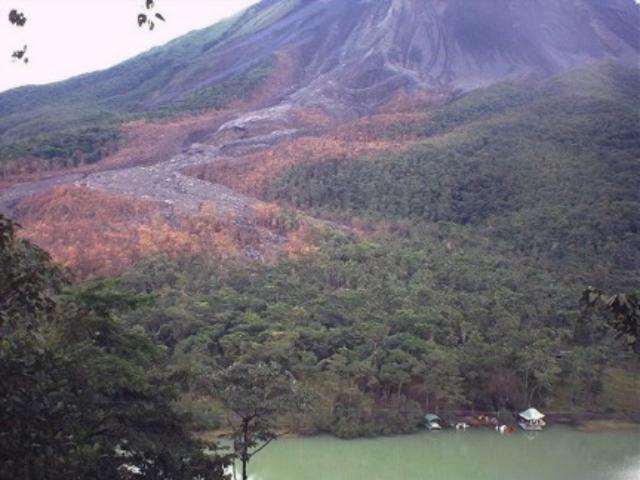 |
Figure 92. Photograph of Arenal taken on 18 September 2000 looking S, showing the swath of the 23 August pyroclastic flows. Cedeño lake lies in the foreground. Photo taken by William G. Melson from the overlook just N of Cedeño lake. |
After visiting Arenal with colleagues at OVSCICORI-UNA, William G. Melson noted that the pyroclastic flows had the character of a block-bomb-and-ash flow. He noted that prior to the event, a spatter cone grew at the N rim of Crater C. Although material regularly sloughed off this cone in smaller, hot mass-wasting events and occasional pyroclastic flows, on 23 August there was a substantial ash column and fallback pyroclastic flows.
The descending pyroclastic flows (figures 90 and 91) followed a N-directed erosional channel. Thereafter, they swerved gently E and broadened, leaving a complex pattern of affected zones. At the distal end, a lodge and its cluster of camping shelters stood just outside the burned zone. Pyroclastic flows had not descended quite so far in this direction in the recent past.
Contrary to some press reports, the eruption on 23 August was not inordinately large and was considerably smaller than the 1968 outbursts. Those much more violent outbursts took on the order of 80 lives, destroyed two towns, and discharged numerous ballistic blocks, including some that landed up to 5 km from the vent.
Although it remains potentially fatal to venture onto Arenal's slopes, tourists continue to repeatedly do so. For example, on 6 July 1988 a man from Pennsylvania was struck by a bomb and killed while standing next to the summit crater. In February 1999, Steve O'Meara found lodge personnel handing out crude maps to tourists. Navigating on the basis of these maps, some tourists found themselves dodging dislodged boulders. One injured tourist had to be escorted off the volcano. Authorities confront the complex and difficult balance that weighs public safety against tourism, resort development, and public access.
OVSICORI-UNA reports and related data. OVSICORI-UNA reported that on 23 August various seismic events occurred associated with the emplacement of the N-flank pyroclastic flows. The pyroclastic flows traveled 2.35 km (straight-line distance) and descended to 620 m elevation. The initial pyroclastic flows had small volumes and went only short distances. Melson's digital seismic instrument detected several prominent peaks in RSAM data on the morning of 23 August (figure 93). According to various reports, the initial pyroclastic flows began around 0930-1000. OVSICORI-UNA stated that the most mobile pyroclastic flows began at 1336 and recurred during an interval of 74 minutes. These were thought to coincide with intervals of vigorous eruptions. This larger flow entered thick forest and halted just tens of meters from the tourist areas called Los Lagos and Senderos, a spot at ~620 m elevation (figure 90). Fallen trees remained unburned at the pyroclastic flow's terminal end, forming a roughly triangular zone over its W side, in the area adjacent to the cabins.
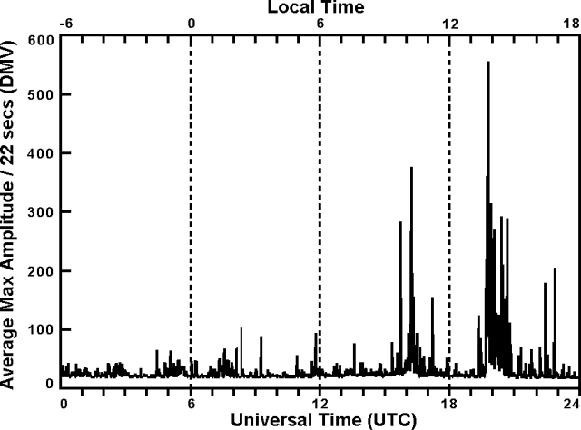 |
Figure 93. Arenal seismic summary showing RSAM calculated from the E-W component. The data were collected on a continuously operating, 3-component seismograph at the indicated times on 23 August 2000. Data registered at the Arenal Observatory Lodge, 2.7 km S of the summit (Macademia station). The bottom scale indicates Universal Time (GMT) and the upper scale, local time. Courtesy of William G. Melson and Jorge Barquero. |
Although in the main body of flow the vegetation had come to rest aligned in the direction of the pyroclastic flow's travel, at the terminal end some trees lay without preferential orientations. Along the front and margin of the area impacted by the pyroclastic flows, some still-standing trees suffered damage, including loss of bark due to ash abrasion. Local winds carried ash columns to the W. At sampling points El Cruce and Lavas (4.6 km WNW and 1.5 km W of Crater C, respectively) the loads of deposited ash amounted to 296 and 1,073 g/m2.
The deposit left by the pyroclastic flows consisted of a sand-sized tephra comprising 20-50% of the deposit, containing semi-rounded blocks with cooling joints and a scoriaceous character, including some bread-crust bombs. The largest of these semi-rounded clasts reached 3 x 1 x 1.8 m. Angular blocks reached 9.5 x 4.4 x 2.8 m. In places, the passing pyroclastic flows both caused erosion and incorporated significant quantities of pre-existing rocks.
During 23 and 24 August there were 42 seismic signals. These were interpreted as associated with the emplacement of pyroclastic flows. Some of these pyroclastic flows originated from collapse at the upper reaches of the actively moving, N-directed lava flows in the area very close to crater C. Others may have involved fallback of the eruptive columns, and collapse of over-steepened summit slopes.
In the months of September and October, Arenal continued to produce active lava flows. Soon after the 23 August event, a lava flow descended to the N, traveling down the same erosional channel over the new pyroclastic-flow deposit. Its front reached ~1,200 m elevation by mid September and though slowing, it reached ~900 m elevation by 3 October. It was followed by a second lava flow, which descended over the first. By 3 October this second flow had advanced to ~1,200 m elevation. Figure 91(B) indicates the positions of the fronts for the first and second lava flows. Both lava flows remained active into at least mid-October.
RSN-ICE-USR reports. Seismic data were collected by the Miravalles-Arenal Seismological and Volcanological Observatory (OSIVAM) and the National Seismological Network (RSN) over the months leading up to the 23 August event (figure 94). Their instruments detected an increase in the tremor signals several hours before the first outburst, and the seismic noise was stronger during subsequent hours due to the flows that lasted until the late afternoon of 23 August. The RSN and their affiliates at ICE-UCR reported that Arenal's activity increased at about 0955 on 23 August. The resulting pyroclastic flows were accompanied by strong ash and gas columns more than 1 km high. Ash fall during the course of the eruptions brought darkness to the vicinity of Arenal as far as the town of Tilarán, 20 km to the W. The number of pyroclastic flows on 23 August was estimated to be at least 20.
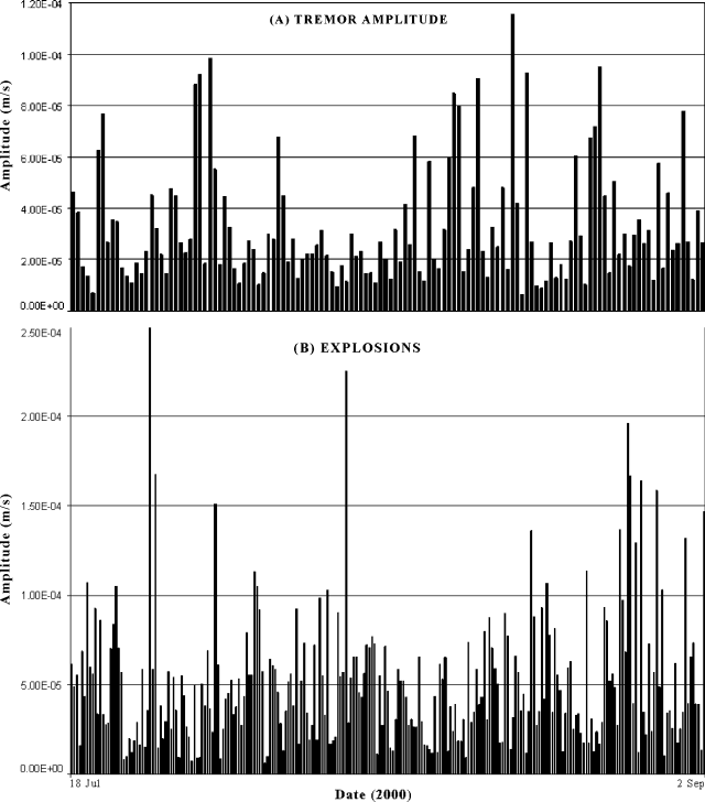 |
Figure 94. Arenal seismic data covering the interval 19 June to 3 September 2000, composed of (A) tremor amplitude and (B) amplitude of explosion events. All data were registered on digital instrument(s) at undisclosed location(s). Courtesy of Ivonne Arroyo and Francisco Arias, OSIVAM. |
On the basis of field surveys on the day of the event, Guillermo Alvarado estimated the velocity of the pyroclastic flows at 80-120 km/hour. The pyroclastic-flow deposits averaged 3 m thick and reached a maximum thickness of 6 m. The flows destroyed OSIVAM-ICE's dry-tilt station E.
Zones prone to small pyroclastic flows, such as those of 23 August, are indicated on a volcanic risk map developed by ICE and Geotérmica Italiana (Alvarado and others, 1988, 1997). That map delineated a hazardous zone extending down this (and other Arenal drainages) and continuing many kilometers beyond lake Cedeño. During an undisclosed time interval, the National Commission of Emergencies (CNE) evacuated several tourist sites near Arenal and closed access to them.
Airplane crash. Additional details have emerged about the airplane that crashed into Arenal on 26 August (impact site indicated on figure 91). The plane carried ten people, presumably two pilots and eight passengers, many of whom were foreign tourists. (BGVN 25:07 stated that the plane carried ten passengers.) One of the passengers was a reporter who had written about the fate of the guide, Ignacio Protti, who died of burns soon after his exposure to the pyroclastic flows. The plane had deviated from its normal route along the coast, probably to gain a view of the area disturbed by the new pyroclastic flows.
References. Alvarado, G.E., Matumoto, T., Borgia, A., and Barquero, R., 1988, Síntesis geovulcanológica del Arenal (Costa Rica): 20 años de continua actividad eruptiva (1968-1988): Rev. Geogr. Amer. Central, v. 25-26, p. 413-459.
Alvarado, G.E., Soto, G.J., Ghigliotti, M., and Frullani, A., 1997, Peligro volcánico del Arenal: Bol. OSIVAM, 8 (15-16):62-82, 1995; San José.
Information Contacts: Observatorio Vulcanologico y Sismologico de Costa Rica, Universidad Nacional (OVSICORI-UNA), Apartado 86-3000, Heredia, Costa Rica; Oficina de Sismología y Vulcanología del Arenal y Miravalles: OSIVAM, Instituto Costarricense de Electricidad (ICE), Apartado 10032-1000, San José, Costa Rica; William Melson, Mineral Sciences, NMNH, Smithsonian Institution, Washington, DC 20560-0119, USA.
September 2000-October 2001 eruptions include pyroclastic flows
During September 2000-October 2001 Arenal issued frequent Strombolian eruptions, occasional avalanches, and several episodes with sizable pyroclastic flows (PFs). Crater D remained fumarolic, with the eruptive activity centered at crater C. Crater C also emitted lava flows (as many as three simultaneously) down Arenal's NE-NW sides. In some cases the site of pyroclastic-flow (PF) generation came from outside crater C, emerging where lava flows perched on the slopes, broke open, and violently released blocks, ash, and gas (block-and-ash flows).
In September-November 2000, OVSICORI-UNA reports noted that the lava flows that began after the 23 August PFs descended the N flank, and during that month had fronts at ~900 m elevation. Sporadic avalanches broke off the lava flow fronts. One such episode at 0630 on 11 September 2000 produced a small ash column. September-November ash columns remained under 500 m above crater C. In September and later months cold loose debris came down parts of the edifice, entering the drainages Calle de Arenas, Manolo, Guillermina, and the larger Tabacón and Agua Caliente rivers.
Deformation, as measured by surveys of the distance network, lacked significant changes during August 2000-November 2000. However, between December and April 2001 there were sudden changes in line length, on the order of a centimeter on all lines, and most appreciable on NE-sector lines. The N-NE sectors are also where most of the lava flows and avalanche instability has occurred. Deformation and tilt changes through 2001 were otherwise described as minor.
Two noteworthy PFs, in August 2000 and March 2001, did not correlate with short-term increases in precursory seismicity. Crater C emitted Strombolian eruptions and N-directed lava flows in late February, and produced PFs during March 2001.
Eruptive episode of late March 2001. During 24 and 26 March 2001 PFs descended Arenal (figure 95) in a series of pulses traveling NNE towards Cedeño lake. Both reports from ICE and OVSICORI-UNA presented the eruptive time as about 1245 on the 24th and continuing until about 1600, with OVSICORI-UNA reporting under six pulses and ICE reporting under 10 pulses. ICE reported that the strongest pulses took place at 1258, 1331, and 1400. After that, the pulses became more frequent but of minor size.
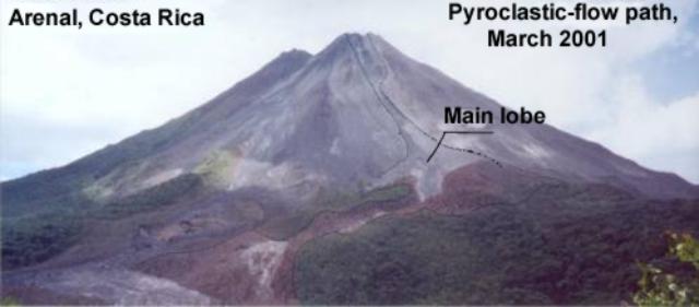 |
Figure 95. Annotated photograph of Arenal's N flanks showing the sketched-in outline of March 2001 pyroclastic-flow (PF) paths. The lower margins of the March 2001 PFs branched into transverse lobes, but the "main lobe" contained the bulk of the deposited material. The 23 August 2000 PFs descended to 620 m elevation, ~ 40-100 m lower, but Cedeño lake and the distal ends of the various PF deposits are absent from this photo. The PFs of March 2001 also produced some erosion on the upper walls of crater C. At the distal end, fine material was deposited atop the August 2000 PF deposits. Courtesy of OVSICORI-UNA. |
ICE reports concluded that PFs reappeared on the 25th, with four pulses between 1348 and 1430. In contrast, OVSICORI-UNA's March report did not conclude that PFs occurred on the 25th and only described pulses on 24 and 26 March. ICE described PFs on the 26th as occurring in fewer than 8 pulses, between the hours of 0917 and 1400. OVSICORI-UNA stated that on the 26th there were fewer than three pulses in the early afternoon. It is clear that a series of PFs occurred over the 3-day (24-26 March) period, with few or none on the 25th.
Seismic signals interpreted by OVSICORI-UNA as PFs typically had durations lasting 100-200 seconds. This provided some measure of their time of origin and descent. These workers found that some very large (up to 36 x 17 x 5 m) incandescent blocks yielded temperatures of over 700°C two days after emplacement. They also reported that on Arenal's slopes the PFs excavated a gully 4 m wide by 500 m long. Field observations also disclosed that PFs or other processes removed part of the summit area, including segments of the cone's upper raised walls.
OVSICORI-UNA noted that the largest PFs accompanied dense clouds of lofted fine ash carried SW. The most distant ash fell over the main entrance to the park, in a pueblo known as El Castillo, and as far as 12 km from the source. OVSICORI-UNA scientists reported the lowest margins of the PFs reached ~660 m elevation.
Field work by ICE scientists Guillermo Alvarado and Francisco Arias revealed PF deposits forming three lobes. The main one was 10-50 m wide and reached 2 km in length. It reached down to 720 m elevation and covered 240,000 m3. When investigated (at an unstated date), its temperature measured over 200°C. The PFs had devastated 6-10 hectares (1 hectare is 104 m2) of primary forest, and the PFs, or related ash fall, heat, or singeing gases, had affected another 15 hectares. After the PFs diminished, lava flows began to escape following the same channel, their fronts later attaining ~1,400 m elevation.
This 24-26 March 2001 episode of PFs was judged to have been of smaller magnitude than the episode of 23 August 2000, a day when 27 pulses of PFs were observed, also directed towards lake Cedeño (BGVN 25:07 and 25:08). On that occasion two people died and another was seriously injured. The March 2001 PFs were without reported injuries or fatalities, although the affected zone was somewhat similar.
According to the ICE report, Alvarado and Arroyo (2000) listed five occasions when Arenal discharged a sequence of PFs for longer than one day (17-21 June 1975, 21-22 February 1989, 9-10 December 1991, 29-30 September 1996, and 19-20 August 1997). Only the sequence during 17-21 June 1975 and their interpretation of one during 24-26 March 2001 lasted more than 2 days. PFs in both of these multi-day sequences attained runout distances of over 1 km; by comparison, the flows during 1989 and 1996 did not surpass half kilometer runout distances. The longest PF occurred in 1975, reaching a 3.5 km runout distance, with the PF's distal portions following the Tabacón river.
April-December 2001. In their report for April 2001 OVSICORI-UNA reported that a lava flow had emerged from crater C decending along the path of the previous month's PFs, with lavas extending from the crater rim to the lava's front at ~1,400 m elevation. Blocks falling off the front reached 950 m elevation in N and NE directions. By the end of May 2001 OVSICORI-UNA noted the descending lavas took the form of three distinct flows that each crossed a different portion of crater C's rim. The three flows continued during June. At that time a sudden change was noted at a thermal spring along the Tabacón valley (NW of Arenal's summit). Its surface dropped by ~60 cm; the temperature of the spring remained stable, however, at 52°C. Deformation in the first half of 2001 showed only minor changes in both surveyed lines and tilt meters. The precise leveling lines on the W flank continued to show deflation on the order of 7 µrad/year.
OVSICORI-UNA stated that on 16 June at 0610 a small PF erupted. Although it failed to cause reported damage, it descended the NW flank in the direction of Balneario de Tabacón (a popular lodging and spa complex with thermal pools) situated farther downslope. During July two of the lava flows (the N- and NE-flank lavas) erupted during May and June stopped progressing. Meanwhile, the third lava flow, which exited crater C on the NW flank, remained active and mobile. During July and August, the eruptive vigor stood at modest levels; still, some eruption columns during July rose 500 m. The August and September reports stated that the one remaining actively progressing lava flow reached 950 and then 900 m elevation, respectively. It descended the same channel followed by the 16 July PF but had advanced little if any farther through October.
More PFs on 19 September 2001, during 1633-1640, and at 1646, were generated by lateral loosening of the lava flow at ~1,300 m elevation; it reached ~900 m elevation. The larger had an associated coffee-colored, mushroom-shaped cloud reaching more than 1 km in height. The associated ash cloud blew SE. PFs descended again on 18 October at 1035 from ~1,200 m elevation NE to 900 m elevation. Winds carried the associated ash cloud W.
Reference. Alvarado, G.E., and Arroyo, I., 2000, The pyroclastic flows of Arenal (Costa Rica) between 1975 and 2000: Origin, frequency, distribution and related hazards: Bulletin Osivam, v. 12, no. 23-24, p. 39-53.
Information Contacts: E. Fernández, E. Duarte, E. Malavassi, R. Sáenz, V. Barboza, R. Van der Laat, T. Marino, E. Hernández, and F. Chavarría, Observatorio Vulcanológico y Sismológico de Costa Rica (OVSICORI-UNA); Jorge Barquero and Wendy Sáenz, Laboratorio de Química de la Atmósfera (LAQAT), Depto. de Química, Universidad Nacional, Heredia, Costa Rica; María Martínez (at both affiliations above); Orlando Vaselli and Franco Tassi, Department of Earth Sciences, University of Florence, Via La Pira 4, 50121 Florence, Italy; Ivonne Arroyo and Guillermo Alvarado, Observatorio Sismológico y Vulcanológico de Arenal y Miravalles (OSIVAM) Instituto Costarricense de Electricidad (ICE), Apdo 10032-San José, Costa Rica; Mauricio Mora, Sección de Sismología, Vulcanología y Exploración Geofísica, Universidad de Costa Rica (UCR), Apdo. 214-2060 San José, Costa Rica.
Ongoing lava extrusion and intermittent pyroclastic flows late 2001 through mid-2003
This report concerns Arenal behavior during November 2001 through August 2003, although some reports were absent (specifically, November and December 2001 and January, February, and April 2002). The available reports portrayed an interval with only a few pyroclastic flows and with plumes generally under 500 m. Lava flows continued to travel down Arenal's slopes; in many cases these flows did not follow well-defined channels. Spatter and related deposition from crater C caused a slightly higher summit elevation. During 2002 lavas descended along many routes down the W, NW, N, and NE flanks. Seismicity remained prominent during the interval, with the number of monthly eruption signals in the hundreds (200-800) and monthly tremor duration in the hundreds of hours.
Seismicity registered during March 2000-December 2001 and for the year 2002 appears as figures 96 and 97, where the numbers of eruptions plotted monthly were inferred. The seismic station VACR (table 22) returned to service on 28 March 2000, registering totals for four days at the end of March consisting of 164 eruptions and 45 hours of tremor. Also reported this month, the electronic distance measuring network (sub-radial lines) continued to show a contraction averaging 7-10 ppm per year. Similar conclusions were stated for August 2003, although in that case deflation was only mentioned on Arenal's W flank. In accord with that observation, dry tilt in the radial direction showed a deflation equivalent to 5 µrad per year, a value that has prevailed through mid-2003.
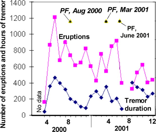 |
Figure 96. Arenal seismicity registered during March 2000-December 2001 (eruptions inferred). The blank areas before March 2000 and during July 2001 were due to equipment down-times. Known pyroclastic flows are shown, but some may be missing because some monthly reports were not available. Courtesy of OVSICORI-UNA. |
 |
Figure 97. Arenal seismicity registered during 2002 (eruption counts seismically inferred). Note change in scale compared to previous figure. The number of eruptions decreased compared to those registered in the year 2000. On the other hand, long-period (LP) earthquakes grew substantially in number during the last months of 2002; tremor repeatedly reached over 400 hours per month during mid-2002. Courtesy of OVSICORI-UNA. |
Table 22. Background describing the OVSICORI-UNA seismic station at Arenal (station VACR), as well as the typical kinds of seismic and audible acoustical signals and corresponding eruptive conditions. Courtesy of OVSICORI-UNA.
| Seismic Station Features | |
| Name | VACR |
| Location | 10.477°N, 84.684°W |
| Elevation | 360 m |
| Location relative to crater | 2.7 km NNE |
| Instrument | Ranger SS-short-period (1 Hz) |
| Gain | 60 decibels (dB) |
| Amplification | 9,605-times normalized at 1 Hz |
| Typical seismic signals recorded at Arenal include those registered in association with explosions and gas eruptions; these signals often correspond to sounds similar to a locomotive or jet engine. Tremors typically correlate to strong degassing and discharge of lava flows. The following types of tremor signal are known to occur: low frequency (typically less than 2.0 Hz), mid-frequency (typically 2.0-3.0 Hz), high frequency (typically above 3.0 Hz), polychromatic (occurring in any frequency range), monochromatic (low-frequency range), and spasmodic (high-frequency range). | |
The number of monthly earthquakes generally dropped or held steady during 2002 compared to 2000-2001 (figure 97). Tremor duration, however, did increase through July 2002, approaching 700 hours a month, typically several times larger than seen in the previous two years. Long-period (LP) earthquakes suddenly became prominent in November and December 2002 (roughly 3- to 7-fold more numerous than seen earlier in 2002).
Two prominent PFs occurred during 2000-2001: in August 2000 and March 2001. They did not correlate with short-term increases in precursory seismicity. However, the August 2000 PF took place after clear increases in the number of earthquakes, the duration of tremor (figure 96), and the number of explosions.
One of a series of PFs judged smaller than the one in March occurred on 16 June 2001. They descended the NW flank for an unstated distance in the direction of Balneario de Tabacón (the Tabacón hot springs and resort complex). Associated seismic signals persisted for ~48 minutes. Although seismicity during June 2001 was comparatively low overall, May 2001 seismicity was moderately high, although not outstanding (figure 96).
During March 2002, Arenal's lava traveled down the N and NE flanks. Eruptive vigor remained low in terms of the number of eruptions and quantity of ejected pyroclastics. On the NE, E, and SE flanks there had been acidic rains and tephra falls. These, in combination with the steep slopes, unconsolidated material, and high rainfall, had caused vegetation to recede. This led to greater erosion, and small cold avalanches swept down the drainages Calle de Arenas, Manolo, Guillermina, and Agua Caliente.
On 18 May 2002 a pyroclastic flow resulted from the structural failure of a lava channel's margin in the region adjacent to the active crater (Crater C). The pyroclastic flow descended to ~900 m elevation, traveling roughly NW. Otherwise, the eruptive vigor around this time continued to remain low; a few eruptions produced columns that rose ~500 m above Crater C. Some minor changes took place in the lava flow channels during May 2002.
Although reports for June and July 2002 were absent during the preparation of this report, the August report mentioned sporadic Strombolian eruptions during those months. Lava that began to be emitted in May 2002 traveled NW and stopped during August. After that, a new lava flow began during August, heading NW in its upper reaches. Very close to the crater, it divided into two arms, heading W and NW. The August effusive activity had increased over recent months, yet, overall the eruptive vigor around that time generally remained low with few eruptions bearing ash, and columns failing to rise more than 500 m above crater C's summit.
Low activity again prevailed during September-December 2002, but lava flows continued to emerge. During September lavas were active on Arenal's W flank, and to some extent on its NW, N, and NE flanks. During October, lavas chiefly descended the NW slopes. During November, the NW-flank lava flow that began to be emitted during August 2002 stopped advancing. A new lava flow began to descend the W flank. Flows down the NW-NE flanks were noted in reports for December 2002-August 2003. In addition, during December 2002 and January and August 2003, some lavas appeared active on the SW flank. During January 2003 plumes again rose to under 500 m high, and calm generally prevailed in February through August as well. Two noteworthy events broke the relative calm of 2003; these occurred during February, May, and September.
On 21 February 2003 at about 0825, NE-flank residents witnessed a small pyroclastic flow descending the same flank. Other details were not disclosed in the OVSICORI-UNA reports; nor was the May PF much described. The 5 September 2003 PF will be discussed in a later report.
Information Contacts: E. Fernández, E. Duarte, E. Malavassi, R. Sáenz, V. Barboza, R. Van der Laat, T. Marino, E. Hernández, and F. Chavarría, Observatorio Vulcanológico y Sismológico de Costa Rica (OVSICORI-UNA), Apartado 86-3000, Heredia, Costa Rica.
Pyroclastic-flow sequence down the N and NE flanks on 5 September
On 5 September the Observatorio Vulcanologico y Sismologico de Costa Rica (OVSICORI-UNA) reported that a new sequence of pyroclastic flows started at 1055 that day (figure 98). At least eight signals related to the collapses were recorded within the next two hours by seismographs at the observatory. Material shed from high-elevation accumulations of lava generated the pyroclastic flows, which descended the N and NE flanks down to 800 m elevation; accompanying ash drifted W and NW. No injuries or deaths occurred, and the main effects were limited to within the National Park boundaries. Patches of vegetation at the flow terminations caught on fire. Similar flows have occurred in recent years (e.g. May 1998, August 2000, and March 2001) affecting the summit and upper areas of the active cone C. No explosive eruptions or extraordinary seismic activity were associated with these latest pyroclastic flows.
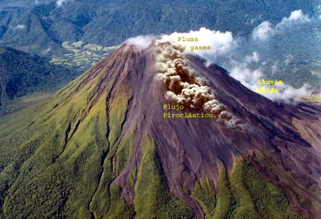 |
Figure 98. Photograph of a pyroclastic flow descending the NE flank of Arenal, 5 September 2003. Courtesy of OVSICORI-UNA. |
Unreported observations from 2002. At the time of the last summary report about Arenal (BGVN 28:08), information from January, February, and April 2002 was not available; those OVSICORI-UNA reports have since been located. Both seismic and volcanic activity were low during those months, without significant pyroclastic flows or energetic eruptions. Pyroclastic flows from other months that had been described in that and other reports all originated from failures along the margins of lava flows, rather than stemming from explosive eruptive processes.
Information Contacts: E. Fernández, E. Duarte, E. Malavassi, R. Sáenz, V. Barboza, R. Van der Laat, T. Marino, E. Hernández, and F. Chavarría, Observatorio Vulcanológico y Sismológico de Costa Rica (OVSICORI-UNA), Apartado 86-3000, Heredia, Costa Rica.
Pyroclastic flows on 6 July generated by detached lavas
A sequence of pyroclastic flows moved down the N and NE flanks in September 2003 (BGVN 28:09). In general, Arenal's behavior during October 2003-March 2004 was similar to past years, with Crater C exhibiting ongoing gas emissions, lava flows, and sporadic Strombolian eruptions, and Crater D emitting fumarolic gases. The month with the highest number of inferred eruption earthquakes and the longest duration of tremor was March 2004 (table 23); long-period earthquakes spiked in May 2004.
Table 23. Seismic activity registered at Arenal's station VACR, October 2003-June 2004. From 24 June onward, the seismic station was out of service. Courtesy of OVSICORI-UNA.
| Month | Eruption earthquakes | Tremor (hours) | Long-period earthquakes |
| Oct 2003 | 997 | 521 | 16 |
| Nov 2003 | 724 | 468 | -- |
| Dec 2003 | -- | -- | -- |
| Jan 2004 | 910 | 610 | 10 |
| Feb 2004 | 896 | 639 | 8 |
| Mar 2004 | 1169 | 661 | 18 |
| Apr 2004 | 957 | 604 | 4 |
| May 2004 | 901 | 405 | 53 |
| Jun 2004 | 974 | 401 | -- |
Typical NE-flank lava flows persisted on 11 October 2003; in addition, some lava flows began to descend the SE flank, but they ceased by month's end. November 2003 reports noted NE-flank lava flows reaching 8 km NE of the edifice. There were a few October eruptions that produced columns of ash more than 500 m above Crater C's rim. During November lava flows persisted on the NE; some extended 8 km. During December 2003, tephra fell on both Crater C's NE and SE sides; acid rain was also noted.
On 12 March 2004 a hot avalanche occurred at the lava front progressing toward Arenal's NE side; the avalanche cascaded downslope and stopped at 850 m elevation. Near the crater's N edge some blocks fell and portions of that mass-wasting event reached vegetation. Eruptive activity declined but crevasses continue to widen. Small cold avalanches were also seen.
Pyroclastic flows on 6 July 2004. At 1319 on 6 July a series of pyroclastic flows descended the NE flank; other pyroclastic flows may have occurred later. Several medium-size pulses affected some patches of vegetation in the lower areas of the cone, ~ 900 m below the summit. The hot avalanches and airborne materials formed a plume of ash and dust blown SW. The pyroclastic flows resulted from the collapse of the upper areas of a lava flow, and impacted an area affected by flows during 1999-2003, but also invaded other areas. This type of phenomena has been common, particularly in recent years, to the N and NE. Figure 99 shows the distal portion of the area of pyroclastic-flow. Deposits included both abundant fine-grained materials and substantial blocks. Direct observations were hampered by the pyroclastic flows as well as cloud cover. Authorities temporarily closed routes around the volcano, but the area was within the National Park in a zone excluding visitors.
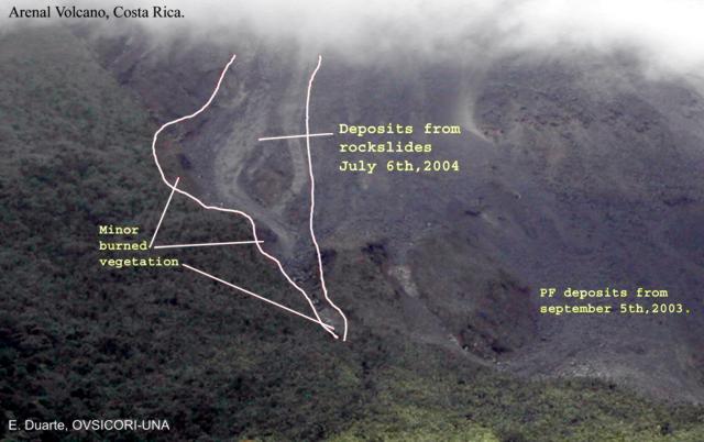 |
Figure 99. The lower portions of Arenal's 6 July 2004 pyroclastic-flow deposit, as outlined by OVSICORI-UNA scientists. Eliecer Duarte provided a rough estimate of distance from the middle left to the lower right side of the area (the 'heel to the tip of the toe') as 250 m. Locations of some of the burned and singed vegetation are indicated. Loose mass-wasted materials (labeled as deposits from rockslides) also accompanied the pyroclastic flows. Courtesy of OVSICORI-UNA. |
Information Contacts: Observatorio Vulcanológico y Sismológico de Costa Rica, Universidad Nacional (OVSICORI-UNA), Apartado 86-3000, Heredia, Costa Rica. (URL: http://www.ovsicori.una.ac.cr).
Frequent pyroclastic flows from crater C since August 2004
As described in the previous Arenal report (BGVN 29:08), on 6 July 2004 a series of pyroclastic flows descended the NE flank. These flows resulted from the collapse of the upper portions of a lava flow, and affected areas beyond those affected by pyroclastic flows during 1999-2003. Similar events have been common in recent years on the volcano's N and NE sides, as Crater C continued to emit gases, lava flows, and sporadic strombolian eruptions through 2004 and at least as late as November 2005. Throughout the period of this report (August 2004-September 2005) the lava flow that began to be emitted towards the NE flank in June 2004 remained active. Occasional blocks spalled off the N edge of the crater towards the NE. The NE and SE flanks continued to be affected by pyroclastic flows and acid rain. Crater D displayed fumarole activity from July 2004 through September 2005. The seismograph station VACR (2.9 km NE of the active Crater C) was out of service from 24 June 2004 until 20 August 2004. Table 24 summarizes the seismicity registered at VACR from August 2004 to September 2005.
Table 24. Seismic activity registered at Arenal's station VACR, August 2004 - September 2005. From 24 June to 20 August 2004 VACR was not operating. No data were reported for December 2004. Courtesy of OVSICORI-UNA.
| Month | Eruption earthquakes | Daily average | LP Events | Tremor (hours) | Comments |
| Aug 2004 | 414 | 35 | -- | 147 | VACR not operating 24 Jun-20 Aug. |
| Sep 2004 | 1125 | 37 | -- | 330 | -- |
| Oct 2004 | 1155 | 37 | 32 | 293 | -- |
| Nov 2004 | 584 | 34 | -- | 153 | -- |
| Dec 2004 | -- | -- | -- | -- | -- |
| Jan 2005 | 540 | 22 | 5 | 357 | VACR operated for 25 days. |
| Feb 2005 | 941 | 35 | 12 | 448 | -- |
| Mar 2005 | 903 | 29 | 15 | 458 | -- |
| Apr 2005 | 567 | 19 | 13 | 592 | -- |
| May 2005 | 618 | 20 | 3 | 600 | -- |
| Jun 2005 | 697 | 23 | 10 | 606 | -- |
| Jul 2005 | 827 | 27 | 23 | 560 | -- |
| Aug 2005 | 597 | 20 | 33 | 548 | -- |
| Sep 2005 | 548 | 18 | 16 | 576 | -- |
During July 2004-January 2005, pyroclastic flows were produced by the collapse of the active lava flow front. In August 2004 some eruptions generated ash columns higher than 500 m above Crater C.
Through most of February 2005 Arenal was hidden by storm clouds, but late in the month it could be observed that the lava flow formerly active on the NE flank had stopped, and no other active flow was seen. The number of eruptions and the amount of ejected pyroclastic material were both reduced in February, and few eruptions produced plumes as high as 500 m. The dome in Crater C continued to grow.
At the beginning of March a SW-trending lava flow was observed, and blocks were ejected to the W. During April 2005 this flow continued, and ejected blocks caused small fires in the surrounding vegetation. A new lava flow began on the SE flank, and blocks ejected to the S and SE again caused fires. In May and June 2005 the SW flow continued. In July the SW lava flow deposited blocks towards the SW, the W and the NW. The SE lava flow released small avalanches off its front and sides. Occasional eruptions produced ash columns higher than 500 m above Crater C.
In August 2005 the SE lava flow stopped. Few eruptions produced ash columns higher than 500 m above Crater C. During September 2005 the SW lava flow was active and deposited blocks to the SW, the W and the NW. The NE and SE flanks continued to be affected by the fall of pyroclastic material and acid rain.
Observatorio Vulcanológico y Sismológico de Costa Rica -Universidad Nacional (OVSICORI-UNA) reported that around 1500 on 2 November a pyroclastic flow was observed on the SE flank of Arenal. On 3 November researchers from OVSICORI-UNA visited the affected area and, contrary to what witnesses had reported, determined that the 2 November event took place on the W flank of the volcano. The mid-size pyroclastic flow produced gas, dust, and ash that were carried by strong winds towards the SE.
Despite the rainy and hazy conditions during the fieldwork it was possible to confirm the affected area and deposits. The movement of lava flows on the SW flank had been observed for the last several months. Materials descending from the summit bifurcate, covering a wide fan that ranges from the W to the SW flank. The main pyroclastic flow affected an area from the summit down to ~ 1000 m altitude. A smooth alley was carved in the steep walls of upper W flank by the transport of incandescent material. Most of the material was deposited in a distal zone 75 m wide, at the break in the steep upper cone slope.
Samples were taken from hot loose blocks spalled from the lava flow; one block was still at 154°C, and was accompanied by several other massive blocks that were fractured by rapid cooling and rough transport. There is evidence that the fine fall material was only deposited in the upper and middle part of the edifice towards the SE.
Given the sustained deposition of material in the area, visitors were advised to follow instructions and safety measures and adhere to the advice of the Park Rangers and tour guides.
Information Contacts: Eliecer Duarte, Observatorio Vulcanológico y Sismológico de Costa Rica, Universidad Nacional (OVSICORI-UNA), Apartado 86-3000, Heredia, Costa Rica. (URL: http://www.ovsicori.una.ac.cr/).
Ongoing activity during 2005-7 included lava flows and pyroclastic flows
Since our last report on Arenal in 2005 (BGVN 31:10), silicic lava emissions were continuous with some occasional more intense periods, including events in May 2006 and September 2007. The agency OVSICORI-UNA noted that from October 2005 through September 2007 the generally low level of activity at the main vent area at Crater C was characterized by continuous emissions of lava, gases, and periodic strombolian eruptions. Pyroclastic flows were occasionally produced, the result of collapse of an active lava flow front. The volcanism was accompanied by characteristic seismic activity, which is indicated in table 25 for the interval September 2005 - December 2006. During this period, Crater D displayed fumarolic activity only; accordingly, the discussion below focuses on activity at Crater C and the Arenal edifice. Note that during the reporting interval, the directions of materials descending the flanks has shifted from time to time.
Table 25. Seismic activity registered at Arenal's station VACR, located 2.7 km NE of the active crater, during September 2005-December 2006. Months with "--" indicate that data were not reported for that month. Data were normalized from mean values for months when the station had incomplete data (25 days in March 2006 and 27 days in April 2006). Courtesy of OVSICORI-UNA.
| Month | Eruption earthquakes | Daily average | LP Events | Tremor (hours) |
| Sep 2005 | 548 | 18 | 16 | 576 |
| Oct 2005 | 631 | 20 | 34 | 468 |
| Nov 2005 | 877 | 29 | 17 | 561 |
| Dec 2005 | -- | -- | -- | -- |
| Jan 2006 | -- | -- | -- | -- |
| Feb 2006 | 867 | 31 | 24 | 536 |
| Mar 2006 | 969 | 39 | 24 | 399 |
| Apr 2006 | 804 | 28 | 33 | 436 |
| May 2006 | -- | -- | -- | -- |
| Jun 2006 | 987 | 33 | 14 | 424 |
| Jul 2006 | 754 | 24 | 37 | 342 |
| Aug 2006 | -- | -- | -- | -- |
| Sep 2006 | -- | -- | -- | -- |
| Oct 2006 | 244 | 8 | 2 | 597 |
| Nov 2006 | 204 | 7 | -- | 626 |
| Dec 2006 | 221 | 7 | -- | 644 |
During October and November 2005, lava flows of comparatively low volume occurred on the cones's SW, W, and NW flanks. In early November, an incandescent pyroclastic flow descended the cone's W flank. Lava continued to descend the SW flank during December and into January 2006 and new flows also took paths down the W and NW flanks. Blocks of lava on the SW and NW flanks tumbled down the slopes, shifting primarily to the N and NE flanks in February. Wherever these viscous blocks of lava detached and tumbled down the flanks of the cone, they started small fires in areas of vegetation.
Mild activity continued through March, April, and the beginning of May 2006, with a few sporadic localized increases. In April, the W lava flow temporarily increased in volume for a short while, then ceased. A new flow developed on the N slope.
10 May 2006 pyroclastic flow. On 10 May a significant pyroclastic flow traveled down Arenal's N flank. Tumbling incandescent blocks of lava, with temperatures up to 1,000°C, collided with each other and the slope of the volcano and broke apart, producing great amounts of ash. An ash-and-gas cloud drifted SW. Although the pyroclastic flow was not coupled with any clearly distinguishable recorded seismic event, it descended the slope in an incandescent torrent, burning and devastating everything in its path. On 20 November 2006, the Arenal Mountain Lodge observatory reported suspected tumbling blocks on the S flank.
Small lava flows on the N slope continued through at least February 2007. Sporadically, small avalanches of lava detached from the flow fronts (these events also occurred on the NE and NW slopes), producing small ash columns that seldom exceeded 500 m above the crater rim.
Eliecer Duarte reported a new lava flow moving SW based on his visit of 28 March 2007, when he found Arenal "as energetic as usual" (figure 100). He wrote that the new SW-directed flow was producing a significant amount of debris that rolled down a wide area. Some of the biggest pieces arrived intact at distal vegetated areas, including ~ 2 km maximum from the source vent at crater C. A lava tongue was visible from the tourist and residential areas. Small pyroclastic flows, derived from dome fragments, broke off and produced small clouds of ash that blew W.
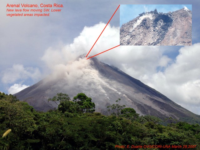 |
Figure 100. Advancing lava flows (masked by low-hanging dusty plumes) on the SW flanks of Arenal, 28 March 2007. The lava flows generated occasional avalanches, small pyroclastic flows, and block-and-ash flows. The inset photo shows the summit area in clear conditions revealing a spire-encrusted lava dome clinging to the upper flanks. Courtesy of E. Duarte, OVSICORI-UNA. |
OVSICORI-UNA reports noted generally low-level activity at Arenal continued through August and September 2007, with little variation, except for infrequent, more active events (such as the one noted below). Ash emissions and their dispersal were generally nominal. The lava fronts continued to tumble down in small avalanches and slides, sometimes reaching the upper part of the forest on the N side, starting small fires. Eruptions produced ash plumes that rose up to 2.2 km altitude. During September 2007, lava domes, lava flows, and hornitos continued to develop.
18 September 2007 pyroclastic flows. According to Jorge Barquero, at about 1000 on 18 September, eyewitnesses at the Arenal Mountain Lodge observatory saw rocks loosening at the base of the dome, first sending small avalanches S and SW and ultimately dropping sufficient quantities of the dome to form somewhat larger pyroclastic flows. The event was recorded by a local seismograph.
Multiple pyroclastic flows traveled S to a runout distance of ~ 1 km (figure 101). During the night, small avalanches continued sporadically; some resulting explosions contained ash. Explosions occurred that occasionally produced airborne ash. Although mainly small avalanches were noted, one larger glowing one descended the S flank and at 1930 that evening a large part of the S flank glowed red. By dawn on 19 September observers saw a new lava flow had emerged from Crater C, the front of which soon became the source of rock avalanches.
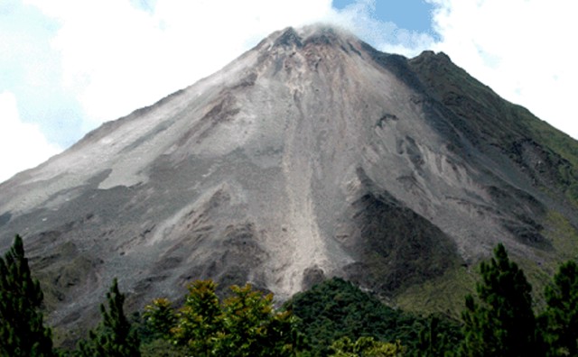 |
Figure 101. A photo of looking straight along the path (and resulting deposits) of the 18 September pyroclastic flow, which traveled directly down Arenal's S flank. The flow had a runout distance of ~ 1 km. Note areas of relatively intact vegetation adjacent the lower portions of the deposit. Courtesy of Jorge Barquero H., Instituto Costarricense de Electricidad (ICE). |
Information Contacts: E. Fernández, E. Duarte, W. Sáenz, V. Barboza, M. Martinez, E. Malavassi, and R. Sáenz, Observatorio Vulcanologico Sismologica de Costa Rica-Universidad Nacional (OVSICORI-UNA), Apartado 86-3000, Heredia, Costa Rica (URL: http://www.ovsicori.una.ac.cr/); Jorge Barquero Hernandez, Instituto Costarricense de Electricidad (ICE), Apartado 5 -2400, Desamparados, San José, Costa Rica.
Continuing explosive and effusive eruptions; block-and-ash flows
Our last report covered generally low-level activity at Arenal through September 2007 (BGVN 32:09). Behavior then included pyroclastic flows to a runout distance of ~ 1 km and a new lava flow emerging from Crater C. This report covers the interval October 2007?June 2008 and originated from those of both the Observatorio Vulcanologico Sismologica de Costa Rica- Universidad Nacional (OVSICORI-UNA) and (ICE).
Impressive incandescent avalanches (block-and-ash flows or pyroclastic flows) traveled down several flanks during June 2008. At least portions of those avalanches broke off from a cone in Crater C and active lava flows high on the edifice.
During the reporting interval, Crater C continued to produce lava flows, gases, sporadic Strombolian eruptions, and avalanches from the lava flow fronts. Observers noticed acid rain and small amounts of ejected pyroclastic material impacting the NE, E, and SE flanks. They also cited loss of vegetation, steep slopes, poorly consolidated material, and high precipitation as factors that triggered small cold avalanches in Calle de Arenas, Manolo, Guillermina, and the river Agua Caliente. Crater D remained fumarolic. Except for the June avalanches, eruptive activity generally remained modest. Some reports noted that the eruptive vigor continued to drop both in terms of the number of eruptions and the amount of ejected pyroclastic material.
OVSICORI-UNA reported that by March 2008, the flow of lava down the S flank had stopped, but a new flow that had begun in February 2008 toward the SW flank was still active. A few eruptions produced ash columns that exceeded 500 m above the vent.
During April 2008, lava moving toward the S flank descended to about 1,400 m elevation. Some blocks had detached near the border of the crater. Sporadically small avalanches occurred and some blocks managed to reach vegetation below, igniting small fires. Some April eruptions produced dark gray ash columns.
Glowing avalanches of June. Jorge Barquero sent us a report on Arenal's behavior during June 2008. Prior to the June events a distinct cone had appeared in Crater C. Its steep sides generated small avalanches of loosened rocks. At about 1000 on 6 June, that cone collapsed, causing a pyroclastic (block-and-ash) flow that descended SE, forming a gully or channel, and laying down a deposit that fanned out at the base of Arenal. Lava also descended into or towards the gully, causing small avalanches.
Some residents heard noises and felt ashfall starting at 0600 on 10 June. At about 0800 these block-and-ash flows became larger. The wind blew ash NW to 4 km from the crater.
After 1730 on 14 June, the failure of the lava flow front sent down an avalanche more violent than those earlier. An hour later the largest block-and-ash flow of the month descended. It descended the channel and produced a large quantity of ash that blew SE and W to distances of 6 km. The area of greatest impact was in the SW portion of the Arenal National Park, where the branches of some vegetation cracked under the weight of the ash. More block-and-ash flows were also observed on 15 and 18 June.
On 11 June Eliecer Duarte and E. Fernández (OVSICORI-UNA) visited the distal parts of the new deposits, documenting the new flow field (figures 102 and 103). The distal area occurred at ~ 900 m elevation on Arenal's outer margins where the slope changes abruptly. A series of alternating lobes contained deposits that were 500°C on 11 June. The individual lobe's thickness reached up to about 3-4 m. The heterogeneous nature of the often angular blocks contrasted with a gray and quite sandy matrix, and included both pre-existing material eroded from the valley walls and more recent juvenile material from the summit. Conspicuous blocls from the block-and-ash flow (10% were 2-3 m in diameter and ~ 20% were ~ 1 m in diameter) are mostly juvenile material from the lava flow. The margins of the fan were covered by a fine dust layer several centimeters thick. On the S flanks, the block-and-ash deposit barely reached a few meters thick. On the N flanks, the deposit reached many tens of meters thick, the result of wind carrying the abundant fine materials in that direction.
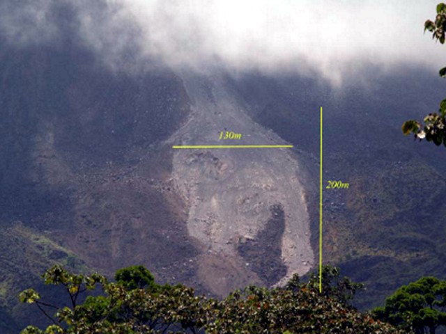 |
Figure 102. A view of the early June 2008 incandescent avalanche deposits on Arenal's S flanks. Courtesy of OVSICORI-UNA. |
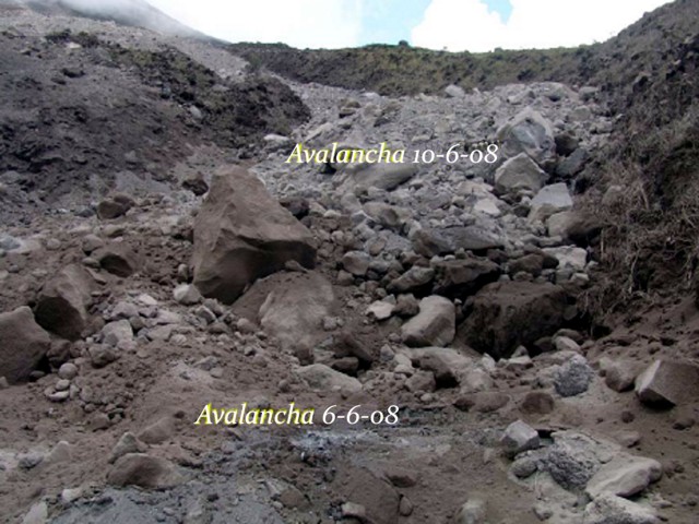 |
Figure 103. Previously incandescent avalanche deposits at Arenal seen on 11 June 2008. Courtesy of OVSICORI-UNA. |
Major S-flank avalanches reported on 6 and 10 June 2008 eroded a radially oriented gully (an avalanche chute). Later avalanches down this direction tended to form channelized deposits. A dark colored thick lava flow present at the summit (figure 104) provided an important source of materials in the deposits. The S-flank avalanches funneled through the gully, fracturing particles into finer grain sizes and generating columns of ash. During the visit, the team observed several avalanches containing large blocks that were similarly reduced in volume as they bounced through the gully. Some of these blocks arrived at the lower part of the fan with temperatures between 800 and 1,000°C. The large blocks seemingly cracked as the result of thermal shock, a process accelerated during a strong rainstorm.
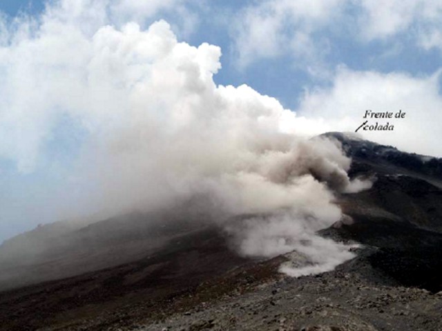 |
Figure 104. Arenal's summit as seen looking up the new avalanche chute (steaming). At the head of the chute lies a thick black lava flow (labeled lava front "Frente de colada"). Courtesy of OVSICORI-UNA. |
Information Contacts: E. Fernández, E. Duarte, W. Sáenz, V. Barboza, M. Martinez, E. Malavassi, and R. Sáenz, Observatorio Vulcanologico Sismologica de Costa Rica-Universidad Nacional (OVSICORI-UNA), Apartado 86-3000, Heredia, Costa Rica (URL: http://www.ovsicori.una.ac.cr/); Jorge Barquero Hernandez, Instituto Costarricense de Electricidad (ICE), Apartado 5 -2400, Desamparados, San José, Costa Rica.
Ongoing lava flows and pyroclastic flows during August 2008-June 2010
Activity at Arenal during July 2008-14 September 2010 included ongoing eruptions emitting both lava flows and small pyroclastic flows. In the latter part of the reporting interval, scientists noted more rock collapses than eruptions containing pyroclasts.
Vigorous activity through mid-June 2008 consisted of explosive and effusive eruptions and pyroclastic flows down multiple flanks that reached up to 1 km long (BGVN 33:06). The pyroclastic flows left a tongue-like deposit with a central depression along its longitudinal axis. Ongoing eruptions at the active Crater C filled in that depression out to ~ 800 m from the crater rim.
Activity during July-August 2008. The Observatorio Vulcanologico Sismologica de Costa Rica-Universidad Nacional (OVSICORI-UNA) reported that during August 2008, activity originating from Arenal's Crater C consisted of gas emissions, sporadic Strombolian eruptions, and occasional avalanches from lava-flow fronts that traveled down the SW flanks. During July and August 2008 there were fewer explosions than previous months, although one substantial explosion took place on 24 July. These generally calmer conditions had persisted since 18 June 2008 (BGVN 33:06).
OVSICORI-UNA reported that during August 2008, acid rain and small amounts of ejected pyroclastic material affected the NE and SE flanks. Eruptions produced ash plumes that rose to ~ 2.2 km altitude. Small avalanches of volcanic material traveled down several ravines. Crater D experienced only fumarolic activity.
Activity during September 2008. An OVSICORI field report from 16 September 2008 documented morphological changes at Arenal during the previous several months, including burnt vegetation on the E and NE flanks, especially toward the summit (figure 105).
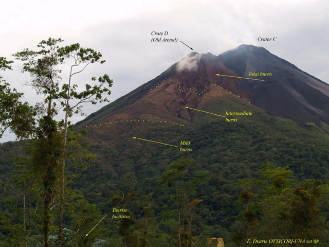 |
Figure 105. Areas of burnt vegetation as seen in September 2008 at Arenal, illustrating severe burns near the summit. A fine layer of dust covering the burnt vegetation that originated from minor pyroclastic flows on the W side. Courtesy E. Duarte, OVSICORI-UNA. |
Most notably on the SW flanks, the paths of pyroclastic flows from June 2008 had become increasingly covered by debris, including lava blocks and material from smaller pyroclastic flows, forming 800-m-long tongues of elevated, leveed deposits (figures 106-107).
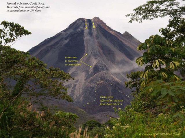 |
Figure 106. September 2008 photo of Arenal's prominent SW flank showing the effects of ongoing incandescent avalanches covering the June 2008 pyroclastic flows. The notch at the summit infilled and abundant material accumulated at 1,200 m elevation, where during 3 months levees grew. This photo shows a variety of features including the notch in the crater rim (A-B), a set of confining levees along the deposits margins, an area with significant new deposition since then (labeled), a mound-like terminal fan that had still accumulated more deposits as late as September 2008, and a distal area of the June 2006 pyroclastic flows. Courtesy of E. Duarte, OVSICORI-UNA. |
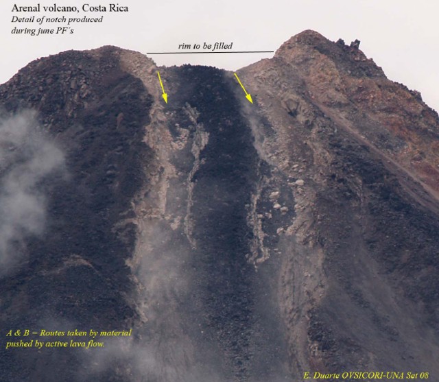 |
Figure 107. September 2008 view of Arenal's notch and upper gully partially filled by recent blocky material. Courtesy of E. Duarte, OVSICORI-UNA. |
A small longitudinal depression (or chute) originally bounded by levees along the June pyroclastic flows had largely been filled by September 2008. Observers noticed these levees in lava flows after 1971 and they have become more common in recent decades.
Material accumulated on either side of the levees, for example, near the lava flow's distal end. There a fan formed, spanning ~ 200 m wide and consisting of pulverized, previously incandescent material. About 800 m below the summit on the SW flank, the levee and gully ended at a barrier that halted movement of eroded material farther downslope. At the summit, the SW edge became blocked with accumulated material, causing some incandescent blocks to roll down the N side.
The SW flank avalanches funneled through the gully. This resulted in particles fractured and ground into finer grain sizes, generating columns of ash. During the visit, the team observed several avalanches containing large blocks that arrived at the lower part of the fan with temperatures between 800 and 1,000°C. The large blocks also seemingly cracked as the result of thermal shock, a process seen to be accelerated during a strong rainstorm.
Activity during January 2009-September 2010. Eruptive activity at Crater C during January 2009 through June 2010 was consistently low but, as before, included gas emissions, sporadic Strombolian eruptions, and occasional avalanches from lava-flow fronts that traveled down the W and SW flanks (also S and SE flanks during February 2010 to May 2010). Acid rain and small amounts of ejected pyroclastic material continued to damage vegetation on the NE and SE flanks (also E flank in January 2010 - September 2010). Eruptions produced ash plumes that rose to an altitude of about 2.2 km. Small avalanches of volcanic material traveled down several ravines, occasionally igniting vegetation. Lava flowed down the S and SW flank in mid-January 2010 through at least early June 2010, causing small avalanches and igniting vegetation. Crater D continued to show only fumarolic activity.
A 17 April 2009 news article reported that Arenal monitoring had increased on 1 April 2009 after the National Commission of Emergencies (CNE) and the National Seismic Network (RSN) detected increased seismicity there.
According to a 15 June 2009 news report, scientists from the University of Costa Rica (UCR) and the Instituto Costarricense de Electricidad (ICE) raised the volcanic alert of the Arenal Volcano in the N-central region of La Fortuna from 2b to 3 on a 4-level scale, based on an increase in phreatic eruptions since early March 2009.
A 17 June 2009 press release from OVSICORI-UNA reported a small, but loud, eruption on 16 June. The eruption caused an avalanche of the accumulated materials at the volcano's summit that traveled down the S and SW flanks. An ash plume subsequently drifted W, over Arenal Volcano National Park, where ~ 50 tourists were evacuated.
According to news articles, an eruption from Arenal on 24 May 2010 produced gas and ash emissions as well as multiple lava flows, again prompting the evacuation of the National Park.
Sulfur dioxide measuring system. Although portable spectrometers often measured sulfur dioxide (SO2) gas fluxes during 2001 and 2002 at ten's of metric tons per day, in recent years these fluxes sometimes amounted to hundreds of tons per day.
During February 2010, scientists installed two permanent SO2-gas-monitoring stations (figure 108). One station sits at an overlook in the National Park and the other at the Observatory Lodge (respectively, ~ 2 km W and 2.7 km S of the summit). The initial data processing was off-site but will ultimately take place at OVSICORI-UNA and Sweden's Chalmers University at Göteborg. The Chalmers staff also assisted in the field with the new installations. Figure 109 shows some key components of the instrumentation in a rugged carrying case.
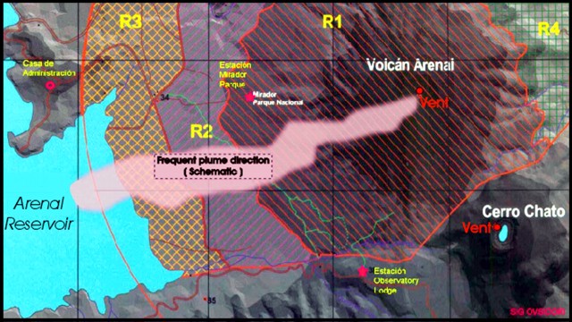 |
Figure 108. A map showing Arenal's permanent SO2 monitoring stations (stars), the administrative facility where telemetered gas data are received ("Casa de Administration"), the typical plume direction, and some other geographic details. N is towards the top; for scale, the N-S distance between grid lines is 2 km. Courtesy of OVSICORI-UNA. |
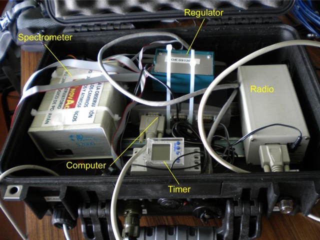 |
Figure 109. Some of the key components of the SO2 monitoring stations deployed at Arenal volcano (and Turrialba). These systems enable scientists to measure SO2 concentration-pathlengths, weather permitting, during daylight hours. When combined with wind-speed data, SO2 fluxes may be calculated. Courtesy of Eliecer Duarte, OVSICORI-UNA. |
The systems employ an upward-looking scanner, which sits outside the box, and sends signals to the spectrometer. Based on peaks at diagnostic wavelengths, the computer calculates the resulting SO2 concentration-pathlength. The measurements are initially transmitted by radio to a common point between the stations. There, internet linkages enable the measurements to proceeded to the Observatory.
The SO2 monitoring instrument's sampling rate can vary from 1 per second to 10 per second depending on the detection of a plume and its concentration-pathlength. The technique, which uses scattered sunlight, is only effective during daylight. It employs a 12-V battery recharged with a solar panel. During cloudy conditions, the instrument only collected 2-5 hours of good data per day. There was a combined total of six stations operating at Arenal and Turrialba. During the course of two years there were two monitoring stations vandalized. Despite these challenges, the systems have helped assess the scale of the degassing problem.
Satellite thermal alerts. Since 1 July 2008, MODVOLC satellite thermal alerts occurred 12 times during the rest of 2008. The bulk took place between 31 August and 25 October, only once in 2009 (two pixels on 24 December), and three times in 2010 through 15 September.
Information Contacts: Observatorio Vulcanologico Sismologica de Costa Rica-Universidad Nacional (OVSICORI-UNA), Apartado 86-3000, Heredia, Costa Rica (URL: http://www.ovsicori.una.ac.cr/); Instituto Costarricense de Electricidad (ICE), Apartado 10032-1000, San José, Costa Rica; Chalmers University of Technology, Department of Earth and Space Science, Göteborg, Sweden; Agence France-Presse (URL: http://www.afp.com/afpcom/en/); Nacion.com, Apartado 10138-1000 San José, Costa Rica (URL: http://wvw.nacion.com/); Tico Times, Apartado 4632-1000, San José, Costa Rica (URL: http://www.ticotimes.net/).
Activity and seismicity decrease; new analysis of acid-rain
Our previous report about Arenal discussed ongoing sporadic eruptive behavior, preliminary information about the 24 May 2010 dome collapse, and the higher frequency of rockfalls through September 2010 (BGVN 35:07). Since October 2010, volcanic activity at Arenal appears to be decreasing. Events like the explosion on 24 July 2010, discussed below (see figure 110) have become rare. Reports from Costa Rica's Volcanological and Seismological Observatory and National University (OVSICORI-UNA) include direct observations of summit activity, seismic analysis, and acid-rain data and provide the basis for this report covering the 24 May, 2010 event in addition to activity from October 2010 to May 2011.
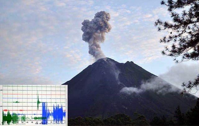 |
Figure 110. At 0538 on 24 July 2010 (local time) an ash explosion at Arenal was recorded seismically and its resulting cloud was photographed. In the lower left-hand corner is the seismic trace of the event, which began suddenly and saturated the record (seismic station VACR; OVSICORI-UNA). Courtesy of Phil Slosberg (OVSICORI-UNA). |
Incandescent avalanche of 24 May 2010. Sudden activity down Arenal's SW flank on 24 May 2010 produced long, incandescent avalanches and pyroclastic flows, forcing the National Park to evacuate visitors on this day. No injuries or damage to infrastructure had been reported during Arenal's activity in May 2010. Previous pyroclastic events had also caused evacuations in June 2009, June 2008, and September 2007.
Beginning at noon on 24 May, incandescent avalanches descended from the summit dome. They affected a sector that has been subject to avalanches in the last 3 years (see figure 111). A field investigation by OVSICORI on 31 May found that material fell from the summit down to 1,200 m elevation and accumulating in a toe 400 m x 80 m. The majority of blocks surpassed 2 m in diameter. Deposits from the dome collapse were still hot when they arrived at the forest that borders Río Agua Caliente. The OVSICORI-UNA field report of 31 May 2010 contains photos and additional details. Several sections of the river scarp show signs of being struck and eroded by direct impact of the incandescent blocks that arrived with high speed. The dome that supplied the block-and-ash flows became visibly deflated but activity culminated through the week with the formation of a new dome toward the E side of the summit. The formation and destruction of domes at the top of Crater C is very common. These domes reach ten's of meters in size and frequently collapse violently, especially when they are destabilized at the crater rim.
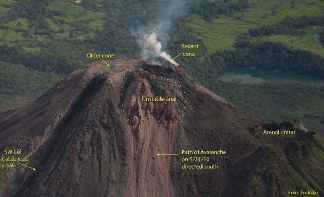 |
Figure 111. Changes in morphology at Arenal's Crater C are visible owing to the 24 May 2010 dome collapse. Located on the eastern side of the summit, the point of failure was attributed to the "Unstable area." Courtesy of E. Duarte (OVSICORI-UNA). |
Decreasing activity. The number of explosive events peaked in February 2010, became regular up to October, but since mid-October they have become sporadic. No lava flows or night-time incandescence was observed on the flanks. Gas emission continued at the active Crater C and fumarolic activity was continuous at Crater D, the pre-1968 summit crater.
Acid-rain affected Arenal's flanks and the NE, E, and SE flanks showed a loss of vegetation. These conditions plus the high amounts of rainfall aggravated erosion on the steep slopes; rockfalls and landslides continued to occur in these valleys: Calle de Arenas, Manolo, Guillermina, and Río Agua Caliente. OVSICORI-UNA released a report on acid-rain measurements that began on 9 April 2003 and ended on 30 November 2010; data from four stations showed generally decreasing acidity with time (figure 112). The trend steadily increased from pH ~4 to ~4.5 for all stations. Although irregular spikes are recorded, the low outliers were generally less acidic with time.
|
Figure 112. Variation of the pH (level of acidity) of rain-water collected from four stations on Arenal. Data points represent measurements from 9 April 2003 to 30 November 2010. Courtesy of OVSICORI-UNA. |
Waldo Taylor assessed seismic data from the local network. The 2010 mid-year ICE report discussed seismicity and the general trend shown in table 26. The large spike in seismic events from 2009 dropped off abruptly the following year.
Table 26. Earthquakes counted at Arenal during 2005-2010. Courtesy of ICE.
| Year | Number of earthquakes |
| 2005 | 3 |
| 2006 | 12 |
| 2007 | 15 |
| 2008 | 47 |
| 2009 | 239 |
| 2010 | 56 |
Gerardo J. Soto discussed Arenal seismicity. "In general terms, the average magnitude increased from 2.0 in 2006 to 2.3 in 2010. The biggest was M 4.1 in 1 November 2009. Mean [focal] depth deepened from 5.5 km in 2006 to about 2 km in 2010. Most of them were between 2 and 5 km deep in 2009-2010, and down to 9 km deep in 2010.
"The number of [respective] earthquakes from September through December 2010 decreased monthly [in the sequence] 24, 12, 9, 3. Epicenters shifted from SE to NW quadrangle of the volcano through time.
"We preliminarily interpret this as a possible withdrawal of magma below the volcano, [on the basis of] focal mechanisms."
Secondary hazards. With Arenal's decrease in explosive activity, no ash collection has been possible this year (2011). A network of seven stations exists for regular sampling. The most effusive event occurred in 1968 when roughly 2 x 10⁵ metric tons of ash fell on the flanks. Later, a hydroelectric project was completed in the 1970s and filled the basin below the volcano with 2.416 x 10⁶ m3 of water (the maximum storage capacity), forming Lake Arenal. From 1992 to 1997, the annual sediment load into the lake contained 1.4% remobilized material from Arenal.
Future activity at Arenal within the next 100 years may include large eruptions with the potential to produce 10 million metric tons of volcanic sediments; within the next 200 years an extreme event could contribute 107 metric tons of volcaniclastics to Lake Arenal (Soto, 1998). The distribution of volcaniclastic sediments is largely controlled by the Río Agua Caliente, a drainage connecting tributaries from Arenal's southern flank. Roughly every 2-5 years there are relatively large debris flows along this river. As recently as the first week of May 2011, intense flooding damaged a bridge by severely undermining the concrete abutments (G.J. Soto, personal communication).
Satellite thermal alerts. Since 15 September 2010 there have been no MODVOLC satellite thermal alerts through February 2011.
References. Soto, G.J., 1998, Cálculo de ceniza eyectada por el Volcán Arenal y ceniza caída en el embalse durante el período 1992-1997; Informe OSV.98.05.ICE, 18 pp. (in Spanish)
OVSICORI-UNA, 2010, Cambios Morfológicos y Avalanchas Incandescentes del 24 de Mayo en el Volcán Arenal. (in Spanish) (URL: http://www.ovsicori.una.ac.cr/vulcanologia/informeDeCampo/2010/InfcampAremayo10.pdf)
Information Contacts: Phil Slosberg and Eliecer Duarte, Observatorio Vulcanologico Sismologica de Costa Rica-Universidad Nacional (OVSICORI-UNA), Apartado 86-3000, Heredia, Costa Rica (URL: http://www.ovsicori.una.ac.cr/); Gerardo J. Soto, Instituto Costarricense de Electricidad (ICE), Apartado 10032-1000, San José, Costa Rica; Waldo Taylor, Sismológico y Vulcanológico de Arenal y Miravalles (OSIVAM), Oficina de Sismología y Vulcanología (OSV), Instituto Costarricense de Electricidad (ICE), Apartado 10032-1000, San José, Costa Rica.
Continued calm with minor gas emissions
Since 1968, Arenal experienced periods of moderate-to-robust volcanic activity that continued through September 2010, when activity declined (BGVN 35:07 and 36:04). This report discusses events between December 2010 and October 2012, a period of continued relative tranquility.
Although sporadic Strombolian explosions were reported in December 2010, they soon ceased; since then, no explosions had occurred through as late as October 2012. According to the Observatorio Vulcanologico Sismologica de Costa Rica-Universidad Nacional (OVSICORI), activity was limited to weak gas emissions, primarily through the NE vent in Crater C and through fumaroles in Crater D (figure 113).
|
Figure 113. A photograph of Arenal's summit taken on 20 February 2011, featuring the volcano's two peaks, both showing weak fumaroles. To the right is crater C, which has been active since 1968; to the left is crater D. Courtesy of Jairo Murillo Solís. |
During the reporting period, the pH of rain-water gradually increased near the volcano. According to OVSICORI, the gradual decrease in rainfall acidity was associated with reduced magmatic activity.
According to OVSICORI, 2012 was one of the years of lowest activity for Arenal since 1968. No volcano-tectonic earthquakes, volcanic earthquakes, or tremors were recorded during the year, and no magmatic activity was detected. OVSICORI (citing Muller and others, 2011) reported that the Electronic Distance Measurement (EDM) network on the W flank of Arenal showed some subsidence from 2008 to near the end of 2011, but then the rate of subsidence decreased and no deformation occurred in 2012.
In June 2012, OVSICORI reported that night observations and long-exposure photographs of the summit revealed no incandescence. According to OVSICORI, the lack of incandescence indicated that gas emissions were of low temperature (probably <300°C), allowing water vapor to condense rapidly upon contact with the atmosphere. Hydrothermal activity remained low with only a few diffuse fumaroles rising from the N flank of Crater C (figure 113).
According to OVSICORI, an Mw 7.6 earthquake on 5 September 2012 centered on the Nicoya Peninsula (Costa Rica) caused moderate rock avalanches at Arenal, mainly dislodging unstable blocks on the active crater's N and NW rim. However, no changes were noted either in the hot springs around the volcano or in surficial expressions of volcanism.
A special issue of Journal of Volcanology and Geothermal Research was devoted to Arenal volcano (see Reference subsection below).
References. Marsh, B. (ed.), 2006, Arenal volcano, Costa Rica: Magma genesis and volcanological processes, Journal of Volcanology and Geothermal Research, v. 157, issues 1-3.
Muller, C., del Potro, R., Gottsmann, J., Biggs, J., and Van der Laat, R., 2011, Combined GPS, EDM and triangulation surveys of the rapid down-slope motion of the western flank of Arenal Volcano, Costa Rica, American Geophysical Union, Fall Meeting 2011, abstract ## V53C-2639 (Poster).
Information Contacts: Observatorio Vulcanologico Sismologica de Costa Rica-Universidad Nacional (OVSICORI-UNA), Apartado 86-3000, Heredia, Costa Rica (URL: http://www.ovsicori.una.ac.cr/); CostaRica21 (URL: http://www.costarica21.com/).
This compilation of synonyms and subsidiary features may not be comprehensive. Features are organized into four major categories: Cones, Craters, Domes, and Thermal Features. Synonyms of features appear indented below the primary name. In some cases additional feature type, elevation, or location details are provided.
Cones |
||||
| Feature Name | Feature Type | Elevation | Latitude | Longitude |
|
Arenal
Pan de Azúcar Canaste Costa Rica, Volcán Río Frio, Volcán Guatusos Peak |
Stratovolcano | 1670 m | 10° 27' 48" N | 84° 42' 12" W |
| Chato, Cerro | Stratovolcano | 1137 m | 10° 26' 36" N | 84° 41' 25" W |
Domes |
||||
| Feature Name | Feature Type | Elevation | Latitude | Longitude |
| Chatito | Dome | 1106 m | 10° 26' 13" N | 84° 41' 6" W |
| Espina | Dome | 1048 m | 10° 26' 18" N | 84° 40' 50" W |
|
|
||||||||||||||||||||||||||
There is data available for 27 confirmed Holocene eruptive periods.
1968 Jul 29 - 2010 Dec 16 (?) ± 15 days Confirmed Eruption Max VEI: 3
| Episode 1 | Eruption Episode | W flank & summit, AR-22/ET-1 tephra | ||||||||||||||||||||||||||||||||||||||||||||||||||||||||||||||||||||||||||||||||||||||||||||||||||||||||||||||||||||||||||||||||||||||||||||||||||||||||||||||||||||||||||||||||||||||||||||||||||
|---|---|---|---|---|---|---|---|---|---|---|---|---|---|---|---|---|---|---|---|---|---|---|---|---|---|---|---|---|---|---|---|---|---|---|---|---|---|---|---|---|---|---|---|---|---|---|---|---|---|---|---|---|---|---|---|---|---|---|---|---|---|---|---|---|---|---|---|---|---|---|---|---|---|---|---|---|---|---|---|---|---|---|---|---|---|---|---|---|---|---|---|---|---|---|---|---|---|---|---|---|---|---|---|---|---|---|---|---|---|---|---|---|---|---|---|---|---|---|---|---|---|---|---|---|---|---|---|---|---|---|---|---|---|---|---|---|---|---|---|---|---|---|---|---|---|---|---|---|---|---|---|---|---|---|---|---|---|---|---|---|---|---|---|---|---|---|---|---|---|---|---|---|---|---|---|---|---|---|---|---|---|---|---|---|---|---|---|---|---|---|---|---|---|---|---|
| 1968 Jul 29 - 2010 Dec 16 (?) ± 15 days | Evidence from Observations: Reported | ||||||||||||||||||||||||||||||||||||||||||||||||||||||||||||||||||||||||||||||||||||||||||||||||||||||||||||||||||||||||||||||||||||||||||||||||||||||||||||||||||||||||||||||||||||||||||||||||||
|
List of 37 Events for Episode 1 at W flank & summit, AR-22/ET-1 tephra
| |||||||||||||||||||||||||||||||||||||||||||||||||||||||||||||||||||||||||||||||||||||||||||||||||||||||||||||||||||||||||||||||||||||||||||||||||||||||||||||||||||||||||||||||||||||||||||||||||||
1922 Oct 5 (?) - 1922 Oct 23 (?) Confirmed Eruption Max VEI: 2
| Episode 1 | Eruption Episode | |||||||||||||||||||||||||||||||||||||||||||||
|---|---|---|---|---|---|---|---|---|---|---|---|---|---|---|---|---|---|---|---|---|---|---|---|---|---|---|---|---|---|---|---|---|---|---|---|---|---|---|---|---|---|---|---|---|---|
| 1922 Oct 5 (?) - 1922 Oct 23 (?) | Evidence from Observations: Reported | ||||||||||||||||||||||||||||||||||||||||||||
|
List of 7 Events for Episode 1
| |||||||||||||||||||||||||||||||||||||||||||||
[ 1915 Feb 5 ] Uncertain Eruption
| Episode 1 | Eruption Episode | ||||||||||||||||||||
|---|---|---|---|---|---|---|---|---|---|---|---|---|---|---|---|---|---|---|---|---|
| 1915 Feb 5 - Unknown | Evidence from Unknown | |||||||||||||||||||
|
List of 2 Events for Episode 1
| ||||||||||||||||||||
1750 ± 50 years Confirmed Eruption Max VEI: 0 (?)
| Episode 1 | Eruption Episode | Summit and NW flank (A2 lava flows) | |||||||||||||||||||
|---|---|---|---|---|---|---|---|---|---|---|---|---|---|---|---|---|---|---|---|---|
| 1750 ± 50 years - Unknown | Evidence from Correlation: Tephrochronology | |||||||||||||||||||
|
List of 2 Events for Episode 1 at Summit and NW flank (A2 lava flows)
| ||||||||||||||||||||
1440 (?) Confirmed Eruption Max VEI: 2 (?)
| Episode 1 | Eruption Episode | Tephra layer AR-21/UN-10 | ||||||||||||||||||||||||||||||||||
|---|---|---|---|---|---|---|---|---|---|---|---|---|---|---|---|---|---|---|---|---|---|---|---|---|---|---|---|---|---|---|---|---|---|---|---|
| 1440 (?) - Unknown | Evidence from Isotopic: 14C (uncalibrated) | ||||||||||||||||||||||||||||||||||
|
List of 5 Events for Episode 1 at Tephra layer AR-21/UN-10
| |||||||||||||||||||||||||||||||||||
1400 (?) Confirmed Eruption Max VEI: 4
| Episode 1 | Eruption Episode | Tephra layer AR-20/ET-2 | ||||||||||||||||||||||||||||||||||
|---|---|---|---|---|---|---|---|---|---|---|---|---|---|---|---|---|---|---|---|---|---|---|---|---|---|---|---|---|---|---|---|---|---|---|---|
| 1400 (?) - Unknown | Evidence from Isotopic: 14C (uncalibrated) | ||||||||||||||||||||||||||||||||||
|
List of 5 Events for Episode 1 at Tephra layer AR-20/ET-2
| |||||||||||||||||||||||||||||||||||
1030 (?) Confirmed Eruption Max VEI: 4
| Episode 1 | Eruption Episode | Tephra layer AR-19/ET-3 | |||||||||||||||||||||||||||||||||||||||
|---|---|---|---|---|---|---|---|---|---|---|---|---|---|---|---|---|---|---|---|---|---|---|---|---|---|---|---|---|---|---|---|---|---|---|---|---|---|---|---|---|
| 1030 (?) - Unknown | Evidence from Correlation: Tephrochronology | |||||||||||||||||||||||||||||||||||||||
|
List of 6 Events for Episode 1 at Tephra layer AR-19/ET-3
| ||||||||||||||||||||||||||||||||||||||||
1020 (?) Confirmed Eruption Max VEI: 4
| Episode 1 | Eruption Episode | Tephra layer AR-18/ET-4 | |||||||||||||||||||||||||||||
|---|---|---|---|---|---|---|---|---|---|---|---|---|---|---|---|---|---|---|---|---|---|---|---|---|---|---|---|---|---|---|
| 1020 (?) - Unknown | Evidence from Correlation: Tephrochronology | |||||||||||||||||||||||||||||
|
List of 4 Events for Episode 1 at Tephra layer AR-18/ET-4
| ||||||||||||||||||||||||||||||
0750 ± 50 years Confirmed Eruption Max VEI: 4
| Episode 1 | Eruption Episode | Tephra layer AR-17/ET-5 | |||||||||||||||||||||||||||||
|---|---|---|---|---|---|---|---|---|---|---|---|---|---|---|---|---|---|---|---|---|---|---|---|---|---|---|---|---|---|---|
| 0750 ± 50 years - Unknown | Evidence from Correlation: Anthropology | |||||||||||||||||||||||||||||
|
List of 4 Events for Episode 1 at Tephra layer AR-17/ET-5
| ||||||||||||||||||||||||||||||
0700 (?) Confirmed Eruption Max VEI: 4
| Episode 1 | Eruption Episode | Tephra layer AR-16/ET-6 | ||||||||||||||||||||||||||||||||||
|---|---|---|---|---|---|---|---|---|---|---|---|---|---|---|---|---|---|---|---|---|---|---|---|---|---|---|---|---|---|---|---|---|---|---|---|
| 0700 (?) - Unknown | Evidence from Correlation: Tephrochronology | ||||||||||||||||||||||||||||||||||
|
List of 5 Events for Episode 1 at Tephra layer AR-16/ET-6
| |||||||||||||||||||||||||||||||||||
0650 ± 100 years Confirmed Eruption Max VEI: 4
| Episode 1 | Eruption Episode | Tephra layer AR-15/ET-7; A3 lava flows | ||||||||||||||||||||||||||||||||||
|---|---|---|---|---|---|---|---|---|---|---|---|---|---|---|---|---|---|---|---|---|---|---|---|---|---|---|---|---|---|---|---|---|---|---|---|
| 0650 ± 100 years - Unknown | Evidence from Isotopic: 14C (calibrated) | ||||||||||||||||||||||||||||||||||
|
List of 5 Events for Episode 1 at Tephra layer AR-15/ET-7; A3 lava flows
| |||||||||||||||||||||||||||||||||||
0550 (?) Confirmed Eruption Max VEI: 4
| Episode 1 | Eruption Episode | Tephra layer AR-14/ET-8M | ||||||||||||||||||||||||
|---|---|---|---|---|---|---|---|---|---|---|---|---|---|---|---|---|---|---|---|---|---|---|---|---|---|
| 0550 (?) - Unknown | Evidence from Correlation: Tephrochronology | ||||||||||||||||||||||||
|
List of 3 Events for Episode 1 at Tephra layer AR-14/ET-8M
| |||||||||||||||||||||||||
0400 (?) Confirmed Eruption Max VEI: 4
| Episode 1 | Eruption Episode | Tephra layer AR-13/ET-8B | ||||||||||||||||||||||||||||||||||||||||||||
|---|---|---|---|---|---|---|---|---|---|---|---|---|---|---|---|---|---|---|---|---|---|---|---|---|---|---|---|---|---|---|---|---|---|---|---|---|---|---|---|---|---|---|---|---|---|
| 0400 (?) - Unknown | Evidence from Correlation: Anthropology | ||||||||||||||||||||||||||||||||||||||||||||
|
List of 7 Events for Episode 1 at Tephra layer AR-13/ET-8B
| |||||||||||||||||||||||||||||||||||||||||||||
0170 BCE ± 200 years Confirmed Eruption Max VEI: 4
| Episode 1 | Eruption Episode | Tephra layer AR-12/ET-9N | |||||||||||||||||||||||||||||
|---|---|---|---|---|---|---|---|---|---|---|---|---|---|---|---|---|---|---|---|---|---|---|---|---|---|---|---|---|---|---|
| 0170 BCE ± 200 years - Unknown | Evidence from Isotopic: 14C (calibrated) | |||||||||||||||||||||||||||||
|
List of 4 Events for Episode 1 at Tephra layer AR-12/ET-9N
| ||||||||||||||||||||||||||||||
0270 BCE (?) Confirmed Eruption Max VEI: 4
| Episode 1 | Eruption Episode | Tephra layer AR-11/ET-9A | ||||||||||||||||||||||||||||||||||
|---|---|---|---|---|---|---|---|---|---|---|---|---|---|---|---|---|---|---|---|---|---|---|---|---|---|---|---|---|---|---|---|---|---|---|---|
| 0270 BCE (?) - Unknown | Evidence from Correlation: Tephrochronology | ||||||||||||||||||||||||||||||||||
|
List of 5 Events for Episode 1 at Tephra layer AR-11/ET-9A
| |||||||||||||||||||||||||||||||||||
0380 BCE ± 200 years Confirmed Eruption Max VEI: 4
| Episode 1 | Eruption Episode | Tephra layer AR-10/ET-9B | ||||||||||||||||||||||||||||||||||
|---|---|---|---|---|---|---|---|---|---|---|---|---|---|---|---|---|---|---|---|---|---|---|---|---|---|---|---|---|---|---|---|---|---|---|---|
| 0380 BCE ± 200 years - Unknown | Evidence from Isotopic: 14C (calibrated) | ||||||||||||||||||||||||||||||||||
|
List of 5 Events for Episode 1 at Tephra layer AR-10/ET-9B
| |||||||||||||||||||||||||||||||||||
0830 BCE ± 500 years Confirmed Eruption Max VEI: 0 (?)
| Episode 1 | Eruption Episode | A4 lava flows | |||||||||||||||||||
|---|---|---|---|---|---|---|---|---|---|---|---|---|---|---|---|---|---|---|---|---|
| 0830 BCE ± 500 years - Unknown | Evidence from Correlation: Tephrochronology | |||||||||||||||||||
|
List of 2 Events for Episode 1 at A4 lava flows
| ||||||||||||||||||||
1250 BCE ± 200 years Confirmed Eruption Max VEI: 4
| Episode 1 | Eruption Episode | Tephra layer AR-9/ET-9 | ||||||||||||||||||||||||||||||||||
|---|---|---|---|---|---|---|---|---|---|---|---|---|---|---|---|---|---|---|---|---|---|---|---|---|---|---|---|---|---|---|---|---|---|---|---|
| 1250 BCE ± 200 years - Unknown | Evidence from Isotopic: 14C (calibrated) | ||||||||||||||||||||||||||||||||||
|
List of 5 Events for Episode 1 at Tephra layer AR-9/ET-9
| |||||||||||||||||||||||||||||||||||
1450 BCE (?) Confirmed Eruption Max VEI: 4
| Episode 1 | Eruption Episode | Tephra layer AR-8/ET-10 | |||||||||||||||||||||||||||||
|---|---|---|---|---|---|---|---|---|---|---|---|---|---|---|---|---|---|---|---|---|---|---|---|---|---|---|---|---|---|---|
| 1450 BCE (?) - Unknown | Evidence from Correlation: Tephrochronology | |||||||||||||||||||||||||||||
|
List of 4 Events for Episode 1 at Tephra layer AR-8/ET-10
| ||||||||||||||||||||||||||||||
1650 BCE (?) Confirmed Eruption Max VEI: 4
| Episode 1 | Eruption Episode | Tephra layer AR-7/ET-11 | |||||||||||||||||||||||||||||
|---|---|---|---|---|---|---|---|---|---|---|---|---|---|---|---|---|---|---|---|---|---|---|---|---|---|---|---|---|---|---|
| 1650 BCE (?) - Unknown | Evidence from Correlation: Tephrochronology | |||||||||||||||||||||||||||||
|
List of 4 Events for Episode 1 at Tephra layer AR-7/ET-11
| ||||||||||||||||||||||||||||||
1770 BCE ± 100 years Confirmed Eruption
| Episode 1 | Eruption Episode | Cerro Chato | |||||||||||||||||||
|---|---|---|---|---|---|---|---|---|---|---|---|---|---|---|---|---|---|---|---|---|
| 1770 BCE ± 100 years - Unknown | Evidence from Isotopic: 14C (calibrated) | |||||||||||||||||||
|
List of 2 Events for Episode 1 at Cerro Chato
| ||||||||||||||||||||
2250 BCE (?) Confirmed Eruption Max VEI: 4
| Episode 1 | Eruption Episode | Tephra layer AR-6/ET-12 | ||||||||||||||||||||||||
|---|---|---|---|---|---|---|---|---|---|---|---|---|---|---|---|---|---|---|---|---|---|---|---|---|---|
| 2250 BCE (?) - Unknown | Evidence from Correlation: Tephrochronology | ||||||||||||||||||||||||
|
List of 3 Events for Episode 1 at Tephra layer AR-6/ET-12
| |||||||||||||||||||||||||
2800 BCE (?) Confirmed Eruption Max VEI: 4
| Episode 1 | Eruption Episode | Tephra layer AR-5/ET-13 | ||||||||||||||||||||||||
|---|---|---|---|---|---|---|---|---|---|---|---|---|---|---|---|---|---|---|---|---|---|---|---|---|---|
| 2800 BCE (?) - Unknown | Evidence from Correlation: Tephrochronology | ||||||||||||||||||||||||
|
List of 3 Events for Episode 1 at Tephra layer AR-5/ET-13
| |||||||||||||||||||||||||
3190 BCE ± 100 years Confirmed Eruption
| Episode 1 | Eruption Episode | Cerro Chato | |||||||||||||||||||
|---|---|---|---|---|---|---|---|---|---|---|---|---|---|---|---|---|---|---|---|---|
| 3190 BCE ± 100 years - Unknown | Evidence from Isotopic: 14C (uncalibrated) | |||||||||||||||||||
|
List of 2 Events for Episode 1 at Cerro Chato
| ||||||||||||||||||||
3350 BCE (?) Confirmed Eruption Max VEI: 4
| Episode 1 | Eruption Episode | Tephra layer AR-4/ET-14 | ||||||||||||||||||||||||
|---|---|---|---|---|---|---|---|---|---|---|---|---|---|---|---|---|---|---|---|---|---|---|---|---|---|
| 3350 BCE (?) - Unknown | Evidence from Correlation: Tephrochronology | ||||||||||||||||||||||||
|
List of 3 Events for Episode 1 at Tephra layer AR-4/ET-14
| |||||||||||||||||||||||||
3900 BCE (?) Confirmed Eruption Max VEI: 4
| Episode 1 | Eruption Episode | Tephra layer AR-3/ET-15 | ||||||||||||||||||||||||
|---|---|---|---|---|---|---|---|---|---|---|---|---|---|---|---|---|---|---|---|---|---|---|---|---|---|
| 3900 BCE (?) - Unknown | Evidence from Correlation: Tephrochronology | ||||||||||||||||||||||||
|
List of 3 Events for Episode 1 at Tephra layer AR-3/ET-15
| |||||||||||||||||||||||||
4450 BCE (?) Confirmed Eruption
| Episode 1 | Eruption Episode | Tephra layer AR-2/ET-16 | |||||||||||||||||||
|---|---|---|---|---|---|---|---|---|---|---|---|---|---|---|---|---|---|---|---|---|
| 4450 BCE (?) - Unknown | Evidence from Correlation: Tephrochronology | |||||||||||||||||||
|
List of 2 Events for Episode 1 at Tephra layer AR-2/ET-16
| ||||||||||||||||||||
5060 BCE ± 150 years Confirmed Eruption Max VEI: 4 (?)
| Episode 1 | Eruption Episode | Tephra layer AR-1/SFB | ||||||||||||||||||||||||||||||||||
|---|---|---|---|---|---|---|---|---|---|---|---|---|---|---|---|---|---|---|---|---|---|---|---|---|---|---|---|---|---|---|---|---|---|---|---|
| 5060 BCE ± 150 years - Unknown | Evidence from Isotopic: 14C (calibrated) | ||||||||||||||||||||||||||||||||||
|
List of 5 Events for Episode 1 at Tephra layer AR-1/SFB
| |||||||||||||||||||||||||||||||||||
There is data available for 2 deformation periods. Expand each entry for additional details.
| Start Date: 2011 | Stop Date: 2013 | Direction: Subsidence | Method: InSAR |
| Magnitude: Unknown | Spatial Extent: Unknown | Latitude: Unknown | Longitude: Unknown |
Remarks: High-resolution InSAR shows that the upper slopes of Arenal experience slow-moving landslides as material is transported downslope in multiple shallow units. | |||
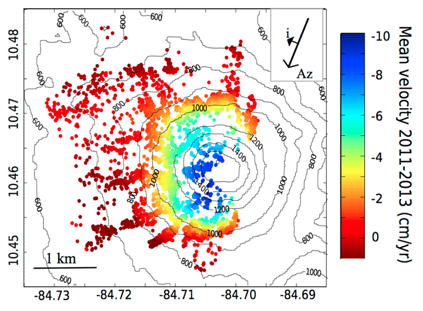 |
Mean line-of-sight velocities found from persistent scatterer analysis between 24.06.2011 and 15.09.2013. Azimuth (Az) direction = ?167?, incidence angle (i) = 37?. From: Ebmeier et al. 2014. |
||
Reference List: Ebmeier et al. 2014.
Full References:
Ebmeier, S. K., Biggs, J., Muller, C., & Avard, G., 2014. Thin-skinned mass-wasting responsible for widespread deformation at Arenal volcano. Frontiers in Earth Science, 2, 35.
| Start Date: 2005 Dec | Stop Date: 2009 Apr | Direction: Subsidence | Method: InSAR |
| Magnitude: Unknown | Spatial Extent: Unknown | Latitude: Unknown | Longitude: Unknown |
Remarks: The western flanks of Arenal are moving downslope at a constant rate of at least 7 cm/year based on InSAR analysis between 2005 and 2009. | |||
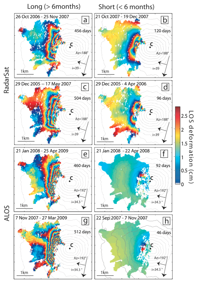 |
Sample (a?d) Radarsat and (e?h) ALOS interferograms showing typical deformation signals for time periods greater than 6 months (Figures 2a, 2c, 2e, and 2g) and less than 6 months (Figures 2b, 2d, 2f, and 2h). All interferograms are wrapped to C band and projected over topographic contours as for Figure 1b. The active summit crater is marked C, as in Figure 1. Azimuth (Az) and incidence angles (i) are indicated for each interferogram. From: Ebmeier et al. 2010. |
||
Reference List: Ebmeier et al. 2010.
Full References:
Ebmeier, S.K., Biggs, CJ, Mather, T.A., Wadge, G. & Amelung, F.., 2010. Steady downslope movement on the western flank of Arenal volcano, Costa Rica. Geochemistry Geophysics Geosystems, 11: Q12004.
There is no Emissions History data available for Arenal.
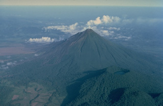 Arenal volcano, seen in this 1983 aerial view from the SE, is a conical stratovolcano that began a long-term eruption in 1968. Densely forested Cerro Chato (lower right) is an older volcano of the Arenal complex. Like Arenal, it is armored with lava flows. The latest eruption of Cerro Chato consisted of phreatomagmatic explosions that formed its summit crater, which is now filled by a lake. At the extreme lower right is Chatito, a lava dome of the Cerro Chato group.
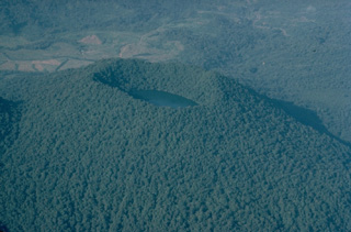 The last eruptions of Cerro Chato volcano, at the SE end of the Arenal volcanic complex, took place about 3500 years ago. Phreatomagmatic explosions produced a crater at the summit of the volcano that is now filled by a lake. This 1983 aerial view from the east shows the densely forested summit of Cerro Chato, with the higher western rim rising above the crater lake.
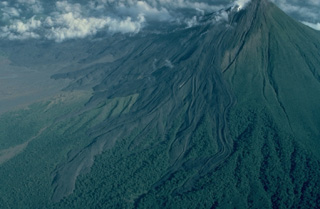 Lava flows armor the western flank of Arenal volcano in Costa Rica. All the flows seen here were emplaced during a long-term eruption that began in 1968. This 1983 aerial view from the SSW shows many individual lava-flow lobes. Prominent flow levees are visible, particularly on the flows at the right. Lava flows from the current Arenal eruption extend 4 km to the NW and about 2.5 km to the SW.
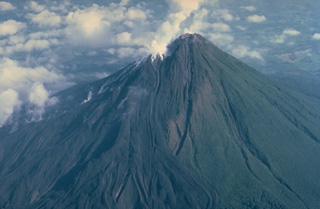 The symmetrical Volcán Arenal is the youngest stratovolcano in Costa Rica and one of its most active. Steam rises from lava flows descending the west flank in this March 1983 view. The oldest known products of Arenal volcano are only about 7000 years old. Arenal's most recent eruptive period began with a major explosion in 1968. Continuous explosive activity accompanied by slow lava effusion has occurred since from vents at the summit and western flank.
 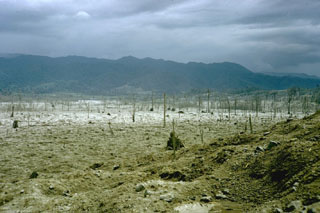 A series of powerful and deadly explosions on 29 July 1968 initiated a new eruptive period at Arenal volcano. This November 1968 photo shows the destruction to vegetation within a broad, devastated area on the western flank. Ballistic ejecta stripped trees of leaves to distances as far as 5 km west of the summit.
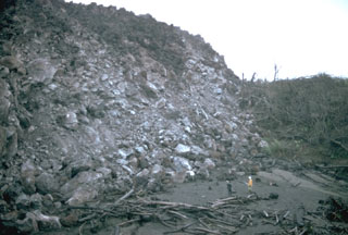 Geologists stand in front of a steep lava flow margin in the Río Tabacón. Lava emission began on 19 September 1968, and in October the flow was advancing at rates of 10-30 m/day. By the time of this photo in November 1968 it had reached about 2.5 km from its source on the western flank. This area has now been buried by younger flows.
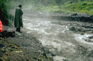 Steam rises from of a small, hot lahar as it travels down the Río Tabacón on the NW flank of Arenal in August 1968, following a powerful explosive eruption that began on 29 July. The lahar damaged the road across the base of the volcano, about 4 km from the summit.
 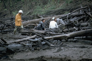 Geologists investigate trees within in a pyroclastic flow deposit along the Río Tabacón on the NW flank of Arenal in November 1968. The trees are aligned parallel to the rapid pyroclastic flow direction. Devastating pyroclastic flows traveled down existing drainages during 29-31 July 1968. One of the largest, with an estimated volume of 0.0018 km3, entered the Río Tabacón. The deposits ranged to more than 30 m thick, but were typically about 10 m. Fumaroles on their surface were active for more than two years.
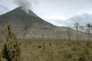 Three craters formed from the summit to the lower west flank of Arenal during the initial stages of a long-lived eruption that began on 29 July 1968. The lowermost crater (Crater A) is the near the center of this photo. Crater B is between Crater A and Crater C, which is producing a gas plume near the summit. Crater A was the source of the largest explosions, pyroclastic flows, and ballistic ejecta.
 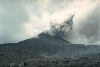 An eruption began at Arenal on 29 July 1968 with major explosions and pyroclastic flows that destroyed two towns and killed 78 people. Three new craters formed on the west flank. This 12 August 1968 view from the WNW flank shows an ash plume with part of the devastated zone in the foreground. Effusion of lava flows that began on 19 September formed an extensive lava field on the western flank.
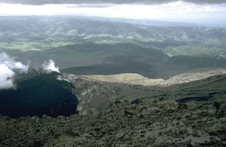 A lava flow issuing from Crater A is seen in April 1969. This crater was the source of the largest explosions at the onset of the eruption in July 1968. The distal end of the lava flow can be seen across the center of the photo. This flow initially traveled down the Río Tabacón on the NW flank, but later sent lobes over a broad area extending to the SW.
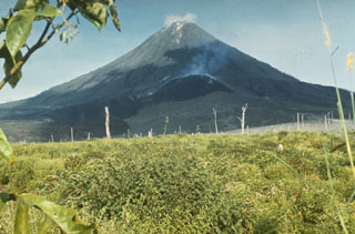 A lava flow descends on the west flank of Arenal volcano on from a degassing vent (Crater A) 6 September 1969. The flow overlies unvegetated terrain at the base of the volcano that was devastated by powerful explosions at the onset of an eruptive period beginning in July 1968. Continuous explosive activity accompanied by slow lava effusion continued from vents at the summit and upper western flank.
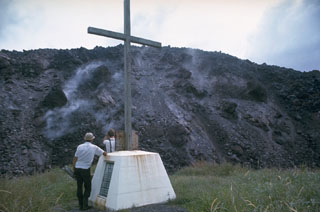 The margins of a lava flow descending the WNW flank of Arenal rise above a monument to victims of a powerful explosive eruption in July 1968. Lava flow effusion began on 19 September 1968 and by the time of this December 1968 photo had reached about 2 km from the vent on the lower west flank.
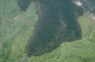 This view shows a lava flow on the WNW flank of Arenal, which originated from Crater A on the lower west flank. At the time of this September 1969 photo the flow had been active for one year. The thick andesite flow initially traveled down the Río Tabacón valley to the NW, but multiple lobes eventually filled different drainages.
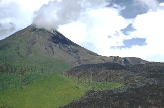 The dark lava flow at the lower right, seen here in June 1970, originated from Crater A on the lower western flank of Arenal in September 1968. Gas plumes rise from the B and C craters at the summit.
 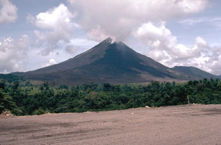 Arenal is seen here from the west in May 1981, with lava flowing from Crater C near the summit. The eruption began in July 1968 with powerful explosions from three craters on the west flank, with the strongest explosions from Crater A. In subsequent years activity migrated towards the summit and took place primarily from Crater C as well as from Crater D (near the former summit).
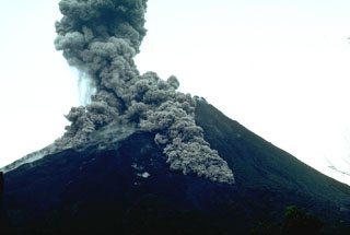 Pyroclastic flows descend the flanks of Arenal on 7 July 1987. This was part of the long eruption that began in 1968. The largest pyroclastic flow in this photo taken from the volcano observatory (2.5 km SSW of the summit) is traveling down the SSE flank.
 A long-term project by botanists from the Smithsonian Institution studied plant succession on lava flows at Arenal volcano. This field site is located on the west flank. Lake Arenal is visible at the upper right.
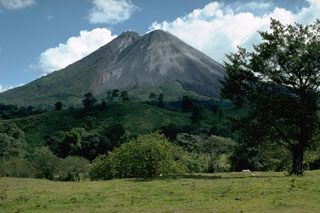 The new post-1968 Arenal cone is to the right in this 1989 view from the NW. The pre-1968 summit forms the peak to the left. Eruptions originating from four craters on the western flank produced the new cone and a lava flow field on the lower western flank.
 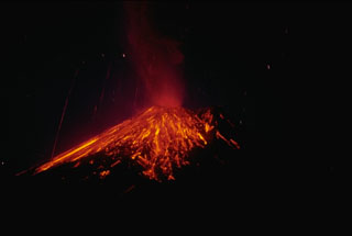 A nighttime time-exposure photo of Arenal on 3 April 1990 shows the paths of incandescent blocks that landed on the upper flanks and traveled downhill. Near-constant lava effusion, accompanied by periods of heightened explosive activity, has occurred since a large explosive eruption in 1968.
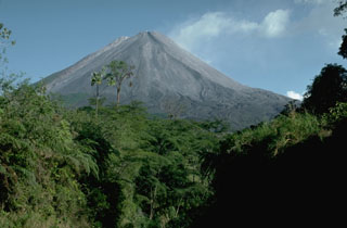 Arenal towers above forests along the Río Agua Caliente on the WSW flank. The Volcán Arenal National Park lies within the Arenal Conservation Area, which combines to protect eight of Costa Rica's 12 biological life zones and includes 16 protected reserves.
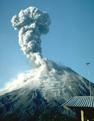 An increase in Strombolian eruptions at Arenal had begun in March 1990. An ash plume rises above the summit on 4 April 1990, seen here from the volcano observatory 2.5 km S. This was part of a long-lived eruption that began in 1968. Explosions produced ash plumes to heights of 1 km above the summit and were accompanied by a lava flow that descended the Río Tabacón on the NW flank down to 700 m altitude. Small pyroclastic flows were also produced.
 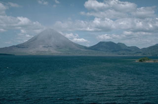 The Arenal volcanic complex, seen here in 1990 from Lake Arenal to its SW, consists of the Arenal edifice (left) and the older Cerro Chato (right), whose flat summit contains a crater and a crater lake. Activity at the complex has migrated to the NW from the Chatito and La Espina lava domes to the right of Cerro Chato.
 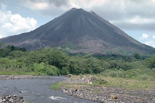 This 1992 view from the SW looks towards Arenal with the new active summit crater just right of the pre-1968 summit, the high point to the left. The 1968-onwards eruption constructed the new cone to the west of the crater from the previous major eruption in about 1525 CE. Lava flows from this eruption cover the unvegetated lower western and southern flanks.
 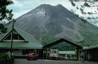 The Arenal Observatory Lodge was constructed at the site of a joint OVSICORI-UNA/Smithsonian Institution volcano observatory established on the SSW flank. The observatory building itself, out of view to the right, was used for seismic monitoring and visual documentation of the frequent eruptive activity from Arenal. This photo was taken in 1992.
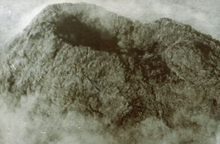 This 1968 view of the vegetated summit crater of Arenal is the only known photo of the summit prior to the major eruption that began that year. The previous significant eruption of Arenal (even larger than in 1968) took place in about 1440 CE, and also produced powerful explosions with pyroclastic flows and lava flows.
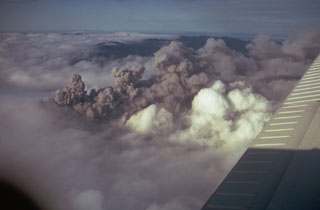 A dark ash plume at Arenal rises above white atmospheric clouds in 1968. A major explosive eruption began on 29 July 1968 from three new craters down the western flank. A series of major explosions took place between the morning of 29 July and the afternoon of 31 July.
 An aerial view overlooks the impact crater field of the 29 July 1968 eruption on the W flank near Pueblo Nuevo. Most of the craters are partially filled by rainfall. These secondary craters, produced by the high-velocity impact of blocks ejected from a new crater that opened on the W flank of Arenal, ranged in size from a few m to 30 m in diameter. The crater field extended as far as about 5 km from the vent. The devastating eruption of 29 July killed about 80 people.
 Officials bring supplies to residents evacuated as a result of the 1968 Arenal eruption. The village of Tabacón was nearly destroyed by ballistic ejecta produced by the powerful explosions at the onset of the eruption on 29 July. The town of Pueblo Nuevo was then established west of the area devastated by the explosions.
 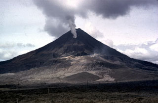 The initial explosions of the 1968 Arenal eruption took place at three craters located from the summit down the west flank. Crater A is visible in the sunlight at the center of the photo; this was the source of the devastating explosions on 29 July. A gas plume rises from Crater B, obscuring Crater C behind it. Lava effusion from Crater C began in September and continued for many years.
 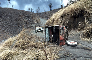 The jeep in the foreground was overturned by pyroclastic flows on 31 July 1968, during a major explosive eruption of Arenal. The 8-10 people who died on this date were within the devastated zone in the background to recover the bodies of people killed by the powerful 29 July eruptions.
 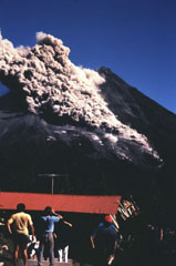 People at the Arenal Volcano Observatory watch a S-flank pyroclastic flow on 23 January 1991. Pyroclastic flows occasionally descended the flanks throughout the long-lived eruption that began in 1968.
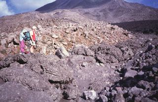 Geologists stand on the margin of a pyroclastic flow deposit from an eruption of Arenal in 1993. In addition to the devastating pyroclastic flows accompanying the start of the eruption in July 1968, more frequent pyroclastic flows occurred in 1975, 1987, 1993, and 1998.
 This is the OSIVAM observatory that monitors seismic and volcanic activity at Arenal and Miravalles volcanoes. The observatory is located in Quebrada Grande, 14 km from the town of Tilarán and west of Lake Arenal.
 A Strombolian eruption is seen here at Arenal on 15 June 1997. The oldest known Arenal products are about 7,000 years old, and the volcano was active for several thousand years contemporaneously with the older Chato volcano (lower right). A recent eruptive period began with a major explosive event in 1968, and frequent explosive activity and slow lava effusion continued through to 2010.
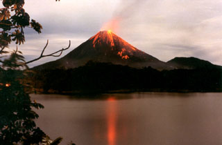 Strombolian eruptions from Arenal volcano are reflected in Lake Arenal in December 1992 during an eruption that began on 29 July 1968. The eruption produced major explosions and pyroclastic flows from three new vents on the west flank, destroying two towns and killing 78 people. The eruption continued through to 2010 and lava flows formed an extensive lava field on the west flank, accompanied by intermittent explosive activity.
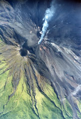 This 8 September 1999 aerial photo shows an active lava flow from the Crater C complex directed towards the NNW, with lobes to the NE. The peak below and to the left of the degassing crater is the pre-1968 summit crater. The 1968-2010 eruption produced lava flows that covered much of the NW-to-SW flanks.
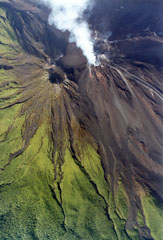 An active lava flow with small plumes rising from the margins can be seen at the upper right descending the Arenal NNW flank from the degassing Crater C complex on 29 June 1999. Below it, descending diagonally NE to the lower right, is another recent flow with clear lateral levees. The inactive crater to the left is Crater D, the pre-1968 summit crater.
  Vegetation was scorched along the margins of a pyroclastic flow that descended the Río Tabacón valley to a point only 400 m from the restaurant of the Tabacón Resort and Spa on 28 August 1993. Pyroclastic flows traveled down four valleys on the W-to-NW flanks on the 28th, and heavy ashfall broke tree limbs and damaged vegetation along a broad swath west of the volcano.
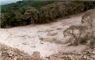 The main pyroclastic flow deposit of 5 May 1998 fills the channel of the Río Tabacón on the NW flank of Arenal. Nearly two dozen pyroclastic flows took place that afternoon. Transported blocks were semi-rounded and had abundant cooling joints; they often contained breadcrust textures from expansion of the partially molten core. Their sizes ranged up to 4 m in diameter. At an undisclosed time of inspection the block's temperatures were as high as 525°C, whereas at 10 cm depth the smaller tephra of the deposit's matrix reached only 100°C.
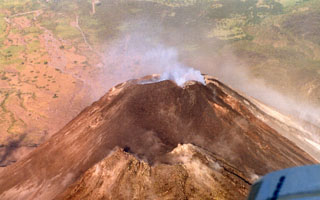 An aerial perspective of the Arenal summit area shows the older cone in the foreground and the active degassing cone in the background. Notice the newly formed small darker-colored cone on the right (north) in this 10 March 1999 photograph.
 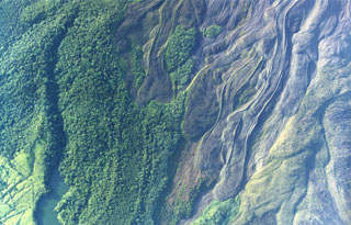 Lobate lava flows were emplaced down the northern flank of Arenal. Note the prominent flow levees and several kipukas (islands of forested land surrounded by lava flows). The eruption that began in 1968 covered much of the northern flank with lava flows. The lake at the lower left is named Peñaranda and lies at the edge of cultivated lands encroaching on the flanks.
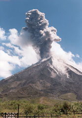 An ash plume rises above Arenal on 2 June 1998, seen here from the west flank. Routine intermittent explosive activity had resumed at this time following major pyroclastic flows on 5 May. Lava flows from the long-lived eruption that began in 1968 can be seen on the volcano's flanks.
 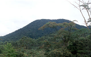 The western flanks of Cerro Chato on the SE side of Arenal are seen here from the OVSICORI-UNA/Smithsonian Institution volcano observatory at Arenal in 1998. At this time, the last known eruption was about 3,500 years ago. Following that eruption, it contained a 500-m-wide summit crater that is partially filled by Laguna Cerro Chato.
 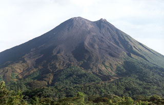 Lava flows from the Arenal eruption that began in 1968 form the surface of the SW flank in this view from the Arenal Volcano Observatory. The active crater (Crater C) is at the summit, while the peak to the right (containing Crater D) is the previous summit.
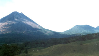 Arenal (left) and Cerro Chato (right) are seen from near El Castillo on the SW side of the volcanic complex. Activity has migrated NW since the earliest eruptions dating back to 38,000 years ago. La Espina and Chatito lava domes are out of view to the right.
 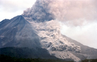 A pyroclastic flow travels down the NNW flank of Arenal on 5 May 1998, over light-colored deposits from earlier flows. As many as 23 pyroclastic flows took place during a 6-hour period that afternoon, descending the upper reaches of the Tabacón drainage basin. The pyroclastic flows reached estimated velocities of 60 km/hour.
 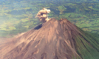 An ash plume rises from the active summit crater of Arenal in this April 1998 view from the south. A small saddle separates the unvegetated post-1968 cone from the pre-1968 cone (right). During April 1998 lava flows traveling down the northern-to-western flanks, and blocks on the NW Crater C wall, broke loose and tiggered small avalanches. This relatively minor activity preceded a larger eruption that produced pyroclastic flows on 5 May.
 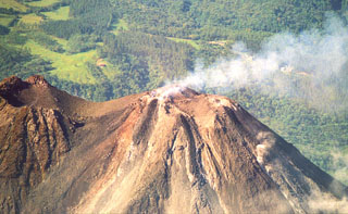 This May 2001 photo shows a gas plume bring dispersed to the west from Crater C, the most recent active summit crater of Arenal. A small saddle separates Crater C from Crater D (left margin), the vent of a major explosive eruption that occurred around 1530 CE.
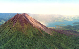 Below the vegetation on the NE Arenal flank is the A2 lava field. These voluminous flows cover the eastern flanks and are considered to have been erupted between about 1700 CE and the start of accurate historical records in Costa Rica in 1800 CE. The vegetation-free flank of the post-1968 cone form the right-hand side of the edifice, and recent lava flows from the 1968-2010 eruption are visible on the lower right-hand flanks with Lake Arenal in the background.
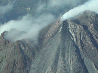 Gas emissions rise from the active Arenal summit crater (Crater C, upper right) in 2003, and a lava flow descends the NE flank to the bottom of the image. Some fumarolic activity is occurring from the pre-1968 crater (Crater D, left). The building at the top left is the Arenal Volcano Observatory.
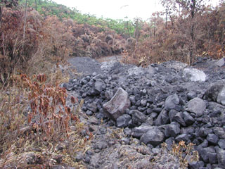 This is a pyroclastic flow deposit that was emplaced down the NE flank of Arenal on 5 September 2003, singeing vegetation on either side of the narrow valley. A series of pyroclastic flows were produced over two hours starting at 1055. The pyroclastic flows originated from the collapse of lava flows on the steep upper flank. Accompanying ashfall occurred to the W and NW.
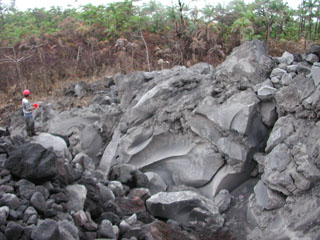 A large 4 x 7 x 35 m block from a lava flow was transported about 900 m within a pyroclastic flow down the NE flank of Arenal on 5 September 2003. The flows were produced by lava flow fronts collapsing, descending to about 800 m elevation. Geologist Erick Fernandez from OVSICORI-UNA measures the dimensions of the block.
 The maps shown below have been scanned from the GVP map archives and include the volcano on this page. Clicking on the small images will load the full 300 dpi map. Very small-scale maps (such as world maps) are not included. The maps database originated over 30 years ago, but was only recently updated and connected to our main database. We welcome users to tell us if they see incorrect information or other problems with the maps; please use the Contact GVP link at the bottom of the page to send us email.
The following 900 samples associated with this volcano can be found in the Smithsonian's NMNH Department of Mineral Sciences collections, and may be availble for research (contact the Rock and Ore Collections Manager). Catalog number links will open a window with more information.
| Catalog Number | Sample Description | Lava Source | Collection Date |
|---|---|---|---|
| NMNH 111216-1 | Wood | -- | -- |
| NMNH 111216-2 | Wood | -- | -- |
| NMNH 111250-1 | Andesite | -- | -- |
| NMNH 111250-10 | Andesite | -- | -- |
| NMNH 111250-11 | Basaltic Andesite | -- | 22 Jun 1971 |
| NMNH 111250-12 | Andesite | -- | 22 Jun 1971 |
| NMNH 111250-14 | Andesite | -- | 22 Jun 1971 |
| NMNH 111250-15 | Basaltic Andesite | -- | 22 Jun 1971 |
| NMNH 111250-16 | Basaltic Andesite | -- | 22 Jun 1971 |
| NMNH 111250-17 | Basaltic Andesite | -- | 22 Jun 1971 |
| NMNH 111250-18 | Andesite | -- | -- |
| NMNH 111250-19 | Basaltic Andesite | -- | 22 Jun 1971 |
| NMNH 111250-2 | Andesite | -- | 22 Jun 1971 |
| NMNH 111250-21 | Basaltic Andesite | -- | 22 Jun 1971 |
| NMNH 111250-22 | Volcanic Ash | -- | 22 Jun 1971 |
| NMNH 111250-23 | Basaltic Andesite | -- | 22 Jun 1971 |
| NMNH 111250-24 | Basaltic Andesite | -- | 22 Jun 1971 |
| NMNH 111250-25 | Basaltic Andesite | -- | 22 Jun 1971 |
| NMNH 111250-26 | Pumice | -- | 22 Jun 1971 |
| NMNH 111250-27 | Diorite | -- | 22 Jun 1971 |
| NMNH 111250-28 | Basaltic Andesite | -- | -- |
| NMNH 111250-29 | Basaltic Andesite | -- | -- |
| NMNH 111250-3 | Andesite | -- | 22 Jun 1971 |
| NMNH 111250-30 | Basaltic Andesite | -- | 22 Jun 1971 |
| NMNH 111250-31 | Basaltic Andesite | -- | 22 Jun 1971 |
| NMNH 111250-32 | Basaltic Andesite | -- | -- |
| NMNH 111250-33 | Basaltic Andesite | -- | 22 Jun 1971 |
| NMNH 111250-34 | Basaltic Andesite | -- | -- |
| NMNH 111250-35 | Basaltic Andesite | -- | -- |
| NMNH 111250-36 | Basaltic Andesite | -- | 22 Jun 1971 |
| NMNH 111250-37 | Basaltic Andesite | -- | 22 Jun 1971 |
| NMNH 111250-38 | Diorite | -- | 22 Jun 1971 |
| NMNH 111250-39 | Lapilli-ash | -- | 1 Jan 1971 |
| NMNH 111250-4 | Volcanic Breccia | -- | 22 Jun 1971 |
| NMNH 111250-40 | Extrusive Volcanic Rock | -- | 22 Jun 1971 |
| NMNH 111250-41 | Diorite | -- | -- |
| NMNH 111250-42 | Extrusive Volcanic Rock | -- | 22 Jun 1971 |
| NMNH 111250-43 | Basaltic Andesite | -- | 22 Jun 1971 |
| NMNH 111250-44 | Basaltic Andesite | -- | 22 Jun 1971 |
| NMNH 111250-45 | Basaltic Andesite | -- | 22 Jun 1971 |
| NMNH 111250-47 | Basaltic Andesite | -- | 22 Jun 1971 |
| NMNH 111250-48 | Basaltic Andesite Lapilli | -- | -- |
| NMNH 111250-49 | Extrusive Volcanic Rock | -- | 22 Jun 1971 |
| NMNH 111250-5 | Tuff | -- | 22 Jun 1971 |
| NMNH 111250-50 | Basalt | -- | 22 Jun 1971 |
| NMNH 111250-51 | Basaltic Andesite | -- | 22 Jun 1971 |
| NMNH 111250-52 | Andesite | -- | 22 Jun 1971 |
| NMNH 111250-53 | Basalt | -- | -- |
| NMNH 111250-54 | Basaltic Andesite | -- | 22 Jun 1971 |
| NMNH 111250-55 | Granodiorite | -- | -- |
| NMNH 111250-56 | Volcanic Ash | -- | -- |
| NMNH 111250-57 | Andesite | -- | 22 Jun 1971 |
| NMNH 111250-58 | Basaltic Andesite | -- | -- |
| NMNH 111250-59 | Andesite | -- | -- |
| NMNH 111250-60 | Andesite | -- | 22 Jun 1971 |
| NMNH 111250-63 | Basaltic Andesite | -- | 22 Jun 1971 |
| NMNH 111250-64 | Andesite | -- | 22 Jun 1971 |
| NMNH 111250-65 | Tuff | -- | -- |
| NMNH 111250-68 | Basaltic Andesite | -- | 22 Jun 1971 |
| NMNH 111250-7 | Basaltic Andesite | -- | 22 Jun 1971 |
| NMNH 111250-70 | Andesite Volcanic Ash | -- | -- |
| NMNH 111250-71 | Volcanic Ash | -- | 21 May 1905 |
| NMNH 111250-8 | Andesite | -- | -- |
| NMNH 111250-9 | Basaltic Andesite | -- | 22 Jun 1971 |
| NMNH 111343 | Andesite | -- | -- |
| NMNH 111344 | Volcanic Ash | -- | -- |
| NMNH 111345 | Lapilli | -- | -- |
| NMNH 111346 | Sulfur | -- | 1 Jan 1969 |
| NMNH 111347 | Andesite | -- | 1 Mar 1969 |
| NMNH 111348 | Andesite | -- | 1 Mar 1969 |
| NMNH 111349 | Wood | -- | -- |
| NMNH 111350 | Andesite Volcanic Ash | -- | -- |
| NMNH 111352 | Sulfur | -- | 14 Mar 1969 |
| NMNH 111353 | Hornblende Diorite | -- | -- |
| NMNH 111355 | Hornblende | -- | -- |
| NMNH 111356 | Hornblende | -- | 1 Jan 1969 |
| NMNH 111356 | Hornblende | -- | 1 Jan 1969 |
| NMNH 111357 | Hornblende | -- | 1 Jan 1969 |
| NMNH 111358 | Hornblende | -- | 22 Jun 1971 |
| NMNH 111359 | Hornblende | -- | -- |
| NMNH 111360 | Hornblende | -- | -- |
| NMNH 111361 | Hornblende | -- | -- |
| NMNH 111362 | Hornblende | -- | -- |
| NMNH 111364 | Sulfur | -- | 1 Jan 1969 |
| NMNH 111365 | Andesite | -- | -- |
| NMNH 111366 | Andesite Volcanic Ash | -- | -- |
| NMNH 111367 | Andesite Volcanic Ash | -- | -- |
| NMNH 111368 | Lapilli-ash | -- | -- |
| NMNH 111369 | Andesite | -- | -- |
| NMNH 111370 | Andesite | -- | -- |
| NMNH 111371 | Andesite | -- | -- |
| NMNH 111372 | Andesite | -- | -- |
| NMNH 111373 | Andesite | -- | -- |
| NMNH 111374 | Andesite | -- | -- |
| NMNH 111375 | Andesite | -- | -- |
| NMNH 111376 | Andesite | -- | -- |
| NMNH 111377 | Andesite | -- | -- |
| NMNH 111378 | Andesite | -- | -- |
| NMNH 111379 | Andesite Volcanic Ash | -- | 1 Jan 1968 |
| NMNH 111380 | Andesite | -- | -- |
| NMNH 111381 | Basaltic Andesite | -- | -- |
| NMNH 111382 | Basaltic Andesite | -- | -- |
| NMNH 111384 | Andesite Volcanic Ash | -- | 25 Mar 1969 |
| NMNH 111385 | Andesite Volcanic Ash | -- | 1 Mar 1969 |
| NMNH 111386 | Andesite | -- | -- |
| NMNH 111387 | Basaltic Andesite | -- | -- |
| NMNH 112150 | Basaltic Andesite | -- | -- |
| NMNH 112151 | Basaltic Andesite | -- | 22 Jun 1971 |
| NMNH 112152 | Basaltic Andesite | -- | -- |
| NMNH 112153 | Basaltic Andesite | -- | -- |
| NMNH 112504-1 | Volcanic Ash | -- | -- |
| NMNH 112504-10 | Volcanic Ash | -- | -- |
| NMNH 112504-11 | Volcanic Ash | -- | -- |
| NMNH 112504-12 | Volcanic Ash | -- | -- |
| NMNH 112504-13 | Volcanic Ash | -- | -- |
| NMNH 112504-14 | Volcanic Ash | -- | -- |
| NMNH 112504-16 | Volcanic Ash | -- | -- |
| NMNH 112504-17 | Volcanic Ash | -- | -- |
| NMNH 112504-2 | Volcanic Ash | -- | -- |
| NMNH 112504-3 | Volcanic Ash | -- | -- |
| NMNH 112504-4 | Volcanic Ash | -- | -- |
| NMNH 112504-5 | Volcanic Ash | -- | -- |
| NMNH 112504-6 | Volcanic Ash | -- | -- |
| NMNH 112504-7 | Volcanic Ash | -- | -- |
| NMNH 112504-8 | Volcanic Ash | -- | -- |
| NMNH 112504-9 | Volcanic Ash | -- | -- |
| NMNH 112517 | Basaltic Andesite | -- | 1 Jan 1971 |
| NMNH 112519 | Andesite | -- | 1 Jan 1971 |
| NMNH 112527-1 | Sublimate Minerals | -- | 22 Jun 1971 |
| NMNH 112527-2 | Sublimate Minerals | -- | 22 Jun 1971 |
| NMNH 112527-3 | Sublimate Minerals | -- | 22 Jun 1971 |
| NMNH 112527-4 | Sublimate Minerals | -- | 22 Jun 1971 |
| NMNH 112527-5 | Sublimate Minerals | -- | 22 Jun 1971 |
| NMNH 112527-6 | Sublimate Minerals | -- | 22 Jun 1971 |
| NMNH 112527-7 | Sublimate Minerals | -- | 22 Jun 1971 |
| NMNH 112527-8 | Sublimate Minerals | -- | 22 Jun 1971 |
| NMNH 112527-9 | Marble | -- | 22 Jun 1971 |
| NMNH 112578-1 | Hornfels | -- | 1 Jun 1971 |
| NMNH 112578-10 | Basalt (?) | -- | 1 Jun 1971 |
| NMNH 112578-11 | Extrusive Volcanic Rock | -- | 1 Jun 1971 |
| NMNH 112578-12 | Hornblende | -- | 1 Jun 1971 |
| NMNH 112578-13 | Extrusive Volcanic Rock | -- | 1 Jun 1971 |
| NMNH 112578-14 | Extrusive Volcanic Rock | -- | 1 Jun 1971 |
| NMNH 112578-15 | Extrusive Volcanic Rock | -- | 1 Jun 1971 |
| NMNH 112578-16 | Scoria | -- | 1 Jun 1971 |
| NMNH 112578-17 | Extrusive Volcanic Rock | -- | 1 Jun 1971 |
| NMNH 112578-18 | Extrusive Volcanic Rock | -- | 1 Jun 1971 |
| NMNH 112578-2 | Carbonized Log | -- | 1 Jun 1971 |
| NMNH 112578-3 | Basalt (?) | -- | 1 Jun 1971 |
| NMNH 112578-4 | Scoria | -- | 1 Jun 1971 |
| NMNH 112578-5 | Basalt (?) | -- | 1 Jun 1971 |
| NMNH 112578-6 | Xenocryst | -- | 1 Jun 1971 |
| NMNH 112578-7 | Basalt | -- | 1 Jun 1971 |
| NMNH 112578-9 | Plagioclase | -- | 1 Jun 1971 |
| NMNH 113071 | Basaltic Andesite | -- | 1 Aug 1973 |
| NMNH 113102-1 | Andesite | -- | -- |
| NMNH 113138-1 | Basaltic Andesite | -- | 17 Apr 1974 |
| NMNH 113139-2 | Basaltic Andesite | -- | 17 Apr 1974 |
| NMNH 113140-3 | Basaltic Andesite | -- | 17 Apr 1974 |
| NMNH 113141-4 | Basaltic Andesite | -- | 17 Apr 1974 |
| NMNH 113142-5 | Basaltic Andesite | -- | 17 Apr 1974 |
| NMNH 113143-6 | Basaltic Andesite | -- | 17 Apr 1974 |
| NMNH 113419 | Basaltic Andesite | -- | -- |
| NMNH 113420 | Basaltic Andesite | -- | -- |
| NMNH 113421 | Basaltic Andesite | -- | -- |
| NMNH 113422 | Basaltic Andesite | -- | 27 Jun 1975 |
| NMNH 113423 | Basaltic Andesite | -- | 27 Jun 1975 |
| NMNH 113424 | Basaltic Andesite | -- | 27 Jun 1975 |
| NMNH 113425 | Basaltic Andesite | -- | 27 Jun 1975 |
| NMNH 113426 | Basaltic Andesite | -- | 27 Jun 1975 |
| NMNH 113627 | Basaltic Andesite | -- | -- |
| NMNH 113628 | Basaltic Andesite | -- | -- |
| NMNH 113629 | Basaltic Andesite | -- | -- |
| NMNH 113630 | Basaltic Andesite | -- | -- |
| NMNH 113631 | Basaltic Andesite | -- | -- |
| NMNH 113633 | Basaltic Andesite | -- | -- |
| NMNH 113634 | Basaltic Andesite | -- | -- |
| NMNH 113635 | Basaltic Andesite | -- | -- |
| NMNH 113636 | Basaltic Andesite | -- | -- |
| NMNH 113637 | Basaltic Andesite | -- | -- |
| NMNH 113638 | Basaltic Andesite | -- | -- |
| NMNH 113718 | Basaltic Andesite | -- | 22 Dec 1976 |
| NMNH 113852-1 | Volcanic Ash | -- | 3 Dec 1977 |
| NMNH 113852-10 | Lapilli | -- | 3 Dec 1977 |
| NMNH 113852-11 | Lapilli | -- | 3 Dec 1977 |
| NMNH 113852-12 | Lapilli | -- | 3 Dec 1977 |
| NMNH 113852-13 | Lapilli | -- | 3 Dec 1977 |
| NMNH 113852-14 | Lapilli | -- | 3 Dec 1977 |
| NMNH 113852-15 | Lapilli | -- | 3 Dec 1977 |
| NMNH 113852-16 | Lapilli | -- | 1 Jan 1977 |
| NMNH 113852-17 | Lapilli | -- | 1 Jan 1977 |
| NMNH 113852-18 | Lapilli | -- | 28 Nov 1977 |
| NMNH 113852-19 | Accretionary Lapilli | -- | 3 Dec 1977 |
| NMNH 113852-2 | Lapilli | -- | 1 Dec 1977 |
| NMNH 113852-20 | Lapilli | -- | 1 Jan 1977 |
| NMNH 113852-21 | Accretionary Lapilli | -- | 2 Dec 1977 |
| NMNH 113852-22 | Accretionary Lapilli | -- | 3 Dec 1977 |
| NMNH 113852-23 | Lapilli | -- | 29 Nov 1977 |
| NMNH 113852-24 | Accretionary Lapilli | -- | 3 Dec 1977 |
| NMNH 113852-25 | Accretionary Lapilli | -- | 3 Dec 1977 |
| NMNH 113852-3 | Accretionary Lapilli | -- | 2 Dec 1977 |
| NMNH 113852-5 | Accretionary Lapilli | -- | 1 Jan 1977 |
| NMNH 113852-6 | Lapilli | -- | 1 Dec 1977 |
| NMNH 113852-7 | Lapilli | -- | 2 Dec 1977 |
| NMNH 113852-8 | Accretionary Lapilli | -- | 2 Dec 1977 |
| NMNH 113852-9 | Lapilli | -- | 1 Jan 1977 |
| NMNH 115532-1 | Andesite | -- | 22 Jun 1971 |
| NMNH 115532-2 | Andesite | -- | 22 Jun 1971 |
| NMNH 115532-3 | Andesite | -- | 22 Jun 1971 |
| NMNH 115532-4 | Andesite | -- | 22 Jun 1971 |
| NMNH 115532-5 | Andesite | -- | 22 Jun 1971 |
| NMNH 115612 | Andesite | -- | 4 Nov 1981 |
| NMNH 115944-7 | Tephra | -- | 1 May 1984 |
| NMNH 115994-1 | Tephra | -- | 1 May 1984 |
| NMNH 115994-10 | Tephra | -- | 1 May 1984 |
| NMNH 115994-11 | Lapilli | -- | 1 May 1984 |
| NMNH 115994-12 | Soil | -- | 1 May 1984 |
| NMNH 115994-13 | Tephra | -- | 1 May 1984 |
| NMNH 115994-14 | Aggregate | -- | 1 May 1984 |
| NMNH 115994-15 | Clay | -- | 1 May 1984 |
| NMNH 115994-16 | Red Clay | -- | 1 May 1984 |
| NMNH 115994-17 | Magnetite | -- | 1 May 1984 |
| NMNH 115994-2 | Tephra | -- | 1 May 1984 |
| NMNH 115994-3 | Lapilli | -- | 1 May 1984 |
| NMNH 115994-4 | Lapilli | -- | 1 May 1984 |
| NMNH 115994-5 | Tephra | -- | 1 May 1984 |
| NMNH 115994-6 | Tephra | -- | 1 May 1984 |
| NMNH 115994-7 | Tephra | -- | 1 May 1984 |
| NMNH 115994-8 | Tephra | -- | 1 May 1984 |
| NMNH 115994-9 | Tephra | -- | 1 May 1984 |
| NMNH 115995-1 | Soil | -- | 1 Jan 1984 |
| NMNH 115995-10 | Tephra | -- | 1 Jan 1984 |
| NMNH 115995-11 | Soil | -- | 1 Jan 1984 |
| NMNH 115995-2 | Soil | -- | 1 Jan 1984 |
| NMNH 115995-3 | Lapilli | -- | 1 Jan 1984 |
| NMNH 115995-4 | Lapilli | -- | 1 Jan 1984 |
| NMNH 115995-5 | Lapilli | -- | 1 Jan 1984 |
| NMNH 115995-6 | Soil | -- | 1 Jan 1984 |
| NMNH 115995-7 | Soil | -- | 1 Jan 1984 |
| NMNH 115995-8 | Tephra | -- | 1 Jan 1984 |
| NMNH 115995-9 | Tephra | -- | 1 Jan 1984 |
| NMNH 115997 | Obsidian | -- | 22 Jun 1971 |
| NMNH 116066-100 | Tephra | -- | -- |
| NMNH 116066-101 | Tephra | -- | -- |
| NMNH 116066-102 | Tephra | -- | -- |
| NMNH 116066-105 | Tephra | -- | -- |
| NMNH 116066-106 | Tephra | -- | -- |
| NMNH 116066-108 | Tephra | -- | -- |
| NMNH 116066-111 | Tephra | -- | -- |
| NMNH 116066-112 | Tephra | -- | -- |
| NMNH 116066-113 | Carbonized Wood | -- | -- |
| NMNH 116066-114 | Kaolinite | -- | -- |
| NMNH 116066-115 | Tephra | -- | -- |
| NMNH 116066-116 | Andesite | -- | -- |
| NMNH 116066-118 | Tephra | -- | -- |
| NMNH 116066-123 | Tephra | -- | -- |
| NMNH 116066-125 | Lapilli | -- | -- |
| NMNH 116066-137 | Tephra | -- | -- |
| NMNH 116066-141 | Lapilli | -- | -- |
| NMNH 116066-144 | Volcanic Rock | -- | -- |
| NMNH 116066-225 | Tephra | -- | 8 Mar 1985 |
| NMNH 116066-226 | Tephra | -- | 8 Mar 1985 |
| NMNH 116066-235 | Andesite | -- | 8 Mar 1985 |
| NMNH 116066-239 | Carbonized Wood | -- | -- |
| NMNH 116066-250 | Basaltic Andesite | -- | 10 Mar 1985 |
| NMNH 116066-375 | Pillow Lava | -- | -- |
| NMNH 116066-388 | Pumice | -- | 22 Apr 1985 |
| NMNH 116066-389 | Xenolith | -- | 22 Apr 1985 |
| NMNH 116066-391 | Lapilli | -- | 22 Apr 1985 |
| NMNH 116066-392 | Lapilli | -- | 22 Apr 1985 |
| NMNH 116066-393 | Lapilli | -- | 22 Apr 1985 |
| NMNH 116066-394 | Lapilli | -- | 22 Apr 1985 |
| NMNH 116066-395 | Lapilli | -- | 22 Apr 1985 |
| NMNH 116066-396 | Lapilli | -- | 22 Apr 1985 |
| NMNH 116066-397 | Tephra | -- | 22 Apr 1985 |
| NMNH 116066-519 | Basaltic Andesite | -- | 27 May 1985 |
| NMNH 116066-520 | Basaltic Andesite | -- | 27 May 1985 |
| NMNH 116066-99 | Tephra | -- | -- |
| NMNH 116221-1 | Vesicular Andesite | CRATER 'A' | -- |
| NMNH 116221-10 | Vesicular Andesite | CRATER 'A' | -- |
| NMNH 116221-11 | Vesicular Andesite | CRATER 'A' | -- |
| NMNH 116221-12 | Vesicular Andesite | CRATER 'A' | -- |
| NMNH 116221-13 | Vesicular Andesite | CRATER 'A' | -- |
| NMNH 116221-14 | Vesicular Andesite | CRATER 'A' | -- |
| NMNH 116221-15 | Vesicular Andesite | CRATER 'A' | -- |
| NMNH 116221-16 | Vesicular Andesite | CRATER 'A' | -- |
| NMNH 116221-17 | Vesicular Andesite | CRATER 'A' | -- |
| NMNH 116221-18 | Vesicular Andesite | CRATER 'A' | -- |
| NMNH 116221-19 | Vesicular Andesite | CRATER 'A' | -- |
| NMNH 116221-2 | Vesicular Andesite | CRATER 'A' | -- |
| NMNH 116221-3 | Vesicular Andesite | CRATER 'A' | -- |
| NMNH 116221-4 | Vesicular Andesite | CRATER 'A' | -- |
| NMNH 116221-5 | Vesicular Andesite | CRATER 'A' | -- |
| NMNH 116221-6 | Vesicular Andesite | CRATER 'A' | -- |
| NMNH 116221-7 | Vesicular Andesite | CRATER 'A' | -- |
| NMNH 116221-8 | Vesicular Andesite | CRATER 'A' | -- |
| NMNH 116221-9 | Vesicular Andesite | CRATER 'A' | -- |
| NMNH 116222-1 | Andesitic Lava | CRATER 'A' | -- |
| NMNH 116222-10 | Andesitic Lava | CRATER 'A' | -- |
| NMNH 116222-11 | Andesitic Lava | CRATER 'A' | -- |
| NMNH 116222-12 | Andesitic Lava | CRATER 'A' | -- |
| NMNH 116222-13 | Andesitic Lava | CRATER 'A' | -- |
| NMNH 116222-14 | Andesitic Lava | CRATER 'A' | -- |
| NMNH 116222-15 | Andesitic Lava | CRATER 'A' | -- |
| NMNH 116222-16 | Andesitic Lava | CRATER 'A' | -- |
| NMNH 116222-2 | Andesitic Lava | CRATER 'A' | -- |
| NMNH 116222-3 | Andesitic Lava | CRATER 'A' | -- |
| NMNH 116222-4 | Andesitic Lava | CRATER 'A' | -- |
| NMNH 116222-5 | Andesitic Lava | CRATER 'A' | -- |
| NMNH 116222-6 | Andesitic Lava | CRATER 'A' | -- |
| NMNH 116222-7 | Andesitic Lava | CRATER 'A' | -- |
| NMNH 116222-8 | Andesitic Lava | CRATER 'A' | -- |
| NMNH 116222-9 | Andesitic Lava | CRATER 'A' | -- |
| NMNH 116223-1 | Andesitic Lava | -- | -- |
| NMNH 116224-1 | Andesite | -- | -- |
| NMNH 116224-10 | Andesite | -- | -- |
| NMNH 116224-11 | Andesite | -- | -- |
| NMNH 116224-12 | Andesite | -- | -- |
| NMNH 116224-13 | Andesite | -- | -- |
| NMNH 116224-14 | Andesite | -- | -- |
| NMNH 116224-15 | Andesite | -- | -- |
| NMNH 116224-16 | Andesite | -- | -- |
| NMNH 116224-2 | Andesite | -- | -- |
| NMNH 116224-3 | Andesite | -- | -- |
| NMNH 116224-4 | Andesite | -- | -- |
| NMNH 116224-5 | Andesite | -- | -- |
| NMNH 116224-6 | Andesite | -- | -- |
| NMNH 116224-7 | Andesite | -- | -- |
| NMNH 116224-8 | Andesite | -- | -- |
| NMNH 116224-9 | Andesite | -- | -- |
| NMNH 116225-1 | Andesite | -- | -- |
| NMNH 116225-2 | Andesite | -- | -- |
| NMNH 116225-3 | Andesite | -- | -- |
| NMNH 116225-4 | Andesite | -- | -- |
| NMNH 116225-5 | Andesite | -- | -- |
| NMNH 116225-6 | Andesite | -- | -- |
| NMNH 116225-7 | Andesite | -- | -- |
| NMNH 116226-1 | Andesite | -- | -- |
| NMNH 116226-10 | Andesite | -- | -- |
| NMNH 116226-11 | Andesite | -- | -- |
| NMNH 116226-12 | Andesite | -- | -- |
| NMNH 116226-13 | Andesite | -- | -- |
| NMNH 116226-14 | Andesite | -- | -- |
| NMNH 116226-15 | Andesite | -- | -- |
| NMNH 116226-2 | Andesite | -- | -- |
| NMNH 116226-3 | Andesite | -- | -- |
| NMNH 116226-4 | Andesite | -- | -- |
| NMNH 116226-5 | Andesite | -- | -- |
| NMNH 116226-6 | Andesite | -- | -- |
| NMNH 116226-7 | Andesite | -- | -- |
| NMNH 116226-8 | Andesite | -- | -- |
| NMNH 116226-9 | Andesite | -- | -- |
| NMNH 116227-1 | Andesite | -- | -- |
| NMNH 116227-10 | Andesite | -- | -- |
| NMNH 116227-11 | Andesite | -- | -- |
| NMNH 116227-12 | Andesite | -- | -- |
| NMNH 116227-13 | Andesite | -- | -- |
| NMNH 116227-14 | Andesite | -- | -- |
| NMNH 116227-15 | Andesite | -- | -- |
| NMNH 116227-16 | Andesite | -- | -- |
| NMNH 116227-2 | Andesite | -- | -- |
| NMNH 116227-3 | Andesite | -- | -- |
| NMNH 116227-4 | Andesite | -- | -- |
| NMNH 116227-5 | Andesite | -- | -- |
| NMNH 116227-6 | Andesite | -- | -- |
| NMNH 116227-7 | Andesite | -- | -- |
| NMNH 116227-8 | Andesite | -- | -- |
| NMNH 116227-9 | Andesite | -- | -- |
| NMNH 116228-1 | Andesite | -- | -- |
| NMNH 116228-10 | Andesite | -- | -- |
| NMNH 116228-11 | Andesite | -- | -- |
| NMNH 116228-12 | Andesite | -- | -- |
| NMNH 116228-2 | Andesite | -- | -- |
| NMNH 116228-3 | Andesite | -- | -- |
| NMNH 116228-4 | Andesite | -- | -- |
| NMNH 116228-5 | Andesite | -- | -- |
| NMNH 116228-6 | Andesite | -- | -- |
| NMNH 116228-7 | Andesite | -- | -- |
| NMNH 116228-8 | Andesite | -- | -- |
| NMNH 116228-9 | Andesite | -- | -- |
| NMNH 116229-1 | Vesicular Andesite | -- | -- |
| NMNH 116229-2 | Vesicular Andesite | -- | -- |
| NMNH 116229-3 | Vesicular Andesite | -- | -- |
| NMNH 116229-4 | Vesicular Andesite | -- | -- |
| NMNH 116229-5 | Vesicular Andesite | -- | -- |
| NMNH 116229-6 | Vesicular Andesite | -- | -- |
| NMNH 116229-7 | Vesicular Andesite | -- | -- |
| NMNH 116229-8 | Vesicular Andesite | -- | -- |
| NMNH 116230-1 | Andesite | -- | -- |
| NMNH 116230-10 | Andesite | -- | -- |
| NMNH 116230-11 | Andesite | -- | -- |
| NMNH 116230-12 | Andesite | -- | -- |
| NMNH 116230-13 | Andesite | -- | -- |
| NMNH 116230-14 | Andesite | -- | -- |
| NMNH 116230-15 | Andesite | -- | -- |
| NMNH 116230-16 | Andesite | -- | -- |
| NMNH 116230-17 | Andesite | -- | -- |
| NMNH 116230-18 | Andesite | -- | -- |
| NMNH 116230-19 | Andesite | -- | -- |
| NMNH 116230-2 | Andesite | -- | -- |
| NMNH 116230-20 | Andesite | -- | -- |
| NMNH 116230-21 | Andesite | -- | -- |
| NMNH 116230-22 | Andesite | -- | -- |
| NMNH 116230-23 | Andesite | -- | -- |
| NMNH 116230-24 | Andesite | -- | -- |
| NMNH 116230-25 | Andesite | -- | -- |
| NMNH 116230-26 | Andesite | -- | -- |
| NMNH 116230-27 | Andesite | -- | -- |
| NMNH 116230-28 | Andesite | -- | -- |
| NMNH 116230-3 | Andesite | -- | -- |
| NMNH 116230-4 | Andesite | -- | -- |
| NMNH 116230-5 | Andesite | -- | -- |
| NMNH 116230-6 | Andesite | -- | -- |
| NMNH 116230-7 | Andesite | -- | -- |
| NMNH 116230-8 | Andesite | -- | -- |
| NMNH 116230-9 | Andesite | -- | -- |
| NMNH 116231-1 | Andesite | -- | -- |
| NMNH 116231-10 | Andesite | -- | -- |
| NMNH 116231-11 | Andesite | -- | -- |
| NMNH 116231-12 | Andesite | -- | -- |
| NMNH 116231-13 | Andesite | -- | -- |
| NMNH 116231-14 | Andesite | -- | -- |
| NMNH 116231-15 | Andesite | -- | -- |
| NMNH 116231-16 | Andesite | -- | -- |
| NMNH 116231-17 | Andesite | -- | -- |
| NMNH 116231-18 | Andesite | -- | -- |
| NMNH 116231-19 | Andesite | -- | -- |
| NMNH 116231-2 | Andesite | -- | -- |
| NMNH 116231-20 | Andesite | -- | -- |
| NMNH 116231-3 | Andesite | -- | -- |
| NMNH 116231-4 | Andesite | -- | -- |
| NMNH 116231-5 | Andesite | -- | -- |
| NMNH 116231-6 | Andesite | -- | -- |
| NMNH 116231-7 | Andesite | -- | -- |
| NMNH 116231-8 | Andesite | -- | -- |
| NMNH 116231-9 | Andesite | -- | -- |
| NMNH 116232-1 | Lava | -- | -- |
| NMNH 116232-10 | Lava | -- | -- |
| NMNH 116232-11 | Lava | -- | -- |
| NMNH 116232-12 | Lava | -- | -- |
| NMNH 116232-13 | Lava | -- | -- |
| NMNH 116232-14 | Lava | -- | -- |
| NMNH 116232-15 | Lava | -- | -- |
| NMNH 116232-16 | Lava | -- | -- |
| NMNH 116232-2 | Lava | -- | -- |
| NMNH 116232-3 | Lava | -- | -- |
| NMNH 116232-4 | Lava | -- | -- |
| NMNH 116232-5 | Lava | -- | -- |
| NMNH 116232-6 | Lava | -- | -- |
| NMNH 116232-7 | Lava | -- | -- |
| NMNH 116232-8 | Lava | -- | -- |
| NMNH 116232-9 | Lava | -- | -- |
| NMNH 116233-1 | Basaltic Tephra | -- | -- |
| NMNH 116233-10 | Basaltic Tephra | -- | -- |
| NMNH 116233-11 | Basaltic Tephra | -- | -- |
| NMNH 116233-12 | Basaltic Tephra | -- | -- |
| NMNH 116233-13 | Basaltic Tephra | -- | -- |
| NMNH 116233-14 | Basaltic Tephra | -- | -- |
| NMNH 116233-15 | Basaltic Tephra | -- | -- |
| NMNH 116233-16 | Basaltic Tephra | -- | -- |
| NMNH 116233-17 | Basaltic Tephra | -- | -- |
| NMNH 116233-18 | Basaltic Tephra | -- | -- |
| NMNH 116233-2 | Basaltic Tephra | -- | -- |
| NMNH 116233-3 | Basaltic Tephra | -- | -- |
| NMNH 116233-4 | Basaltic Tephra | -- | -- |
| NMNH 116233-5 | Basaltic Tephra | -- | -- |
| NMNH 116233-6 | Basaltic Tephra | -- | -- |
| NMNH 116233-7 | Basaltic Tephra | -- | -- |
| NMNH 116233-8 | Basaltic Tephra | -- | -- |
| NMNH 116233-9 | Basaltic Tephra | -- | -- |
| NMNH 116234-1 | Andesite | -- | -- |
| NMNH 116234-2 | Andesite | -- | -- |
| NMNH 116234-3 | Andesite | -- | -- |
| NMNH 116235-1 | Andesite | -- | -- |
| NMNH 116235-10 | Andesite | -- | -- |
| NMNH 116235-11 | Andesite | -- | -- |
| NMNH 116235-12 | Andesite | -- | -- |
| NMNH 116235-13 | Andesite | -- | -- |
| NMNH 116235-14 | Andesite | -- | -- |
| NMNH 116235-15 | Andesite | -- | -- |
| NMNH 116235-16 | Andesite | -- | -- |
| NMNH 116235-17 | Andesite | -- | -- |
| NMNH 116235-18 | Andesite | -- | -- |
| NMNH 116235-2 | Andesite | -- | -- |
| NMNH 116235-3 | Andesite | -- | -- |
| NMNH 116235-4 | Andesite | -- | -- |
| NMNH 116235-5 | Andesite | -- | -- |
| NMNH 116235-6 | Andesite | -- | -- |
| NMNH 116235-7 | Andesite | -- | -- |
| NMNH 116235-8 | Andesite | -- | -- |
| NMNH 116235-9 | Andesite | -- | -- |
| NMNH 116236-1 | Andesite | -- | -- |
| NMNH 116236-2 | Andesite | -- | -- |
| NMNH 116236-3 | Andesite | -- | -- |
| NMNH 116236-4 | Andesite | -- | -- |
| NMNH 116237-1 | Andesite (?) | -- | -- |
| NMNH 116237-2 | Andesite (?) | -- | -- |
| NMNH 116237-3 | Andesite (?) | -- | -- |
| NMNH 116237-4 | Andesite (?) | -- | -- |
| NMNH 116237-5 | Andesite (?) | -- | -- |
| NMNH 116237-6 | Andesite (?) | -- | -- |
| NMNH 116238-1 | Andesite | -- | -- |
| NMNH 116238-2 | Andesite | -- | -- |
| NMNH 116238-3 | Andesite | -- | -- |
| NMNH 116238-4 | Andesite | -- | -- |
| NMNH 116238-5 | Andesite | -- | -- |
| NMNH 116238-6 | Andesite | -- | -- |
| NMNH 116238-7 | Andesite | -- | -- |
| NMNH 116238-8 | Andesite | -- | -- |
| NMNH 116239-1 | Andesitic Lava | -- | -- |
| NMNH 116239-10 | Andesitic Lava | -- | -- |
| NMNH 116239-11 | Andesitic Lava | -- | -- |
| NMNH 116239-12 | Andesitic Lava | -- | -- |
| NMNH 116239-13 | Andesitic Lava | -- | -- |
| NMNH 116239-14 | Andesitic Lava | -- | -- |
| NMNH 116239-15 | Andesitic Lava | -- | -- |
| NMNH 116239-16 | Andesitic Lava | -- | -- |
| NMNH 116239-17 | Andesitic Lava | -- | -- |
| NMNH 116239-18 | Andesitic Lava | -- | -- |
| NMNH 116239-19 | Andesitic Lava | -- | -- |
| NMNH 116239-2 | Andesitic Lava | -- | -- |
| NMNH 116239-3 | Andesitic Lava | -- | -- |
| NMNH 116239-4 | Andesitic Lava | -- | -- |
| NMNH 116239-5 | Andesitic Lava | -- | -- |
| NMNH 116239-6 | Andesitic Lava | -- | -- |
| NMNH 116239-7 | Andesitic Lava | -- | -- |
| NMNH 116239-8 | Andesitic Lava | -- | -- |
| NMNH 116239-9 | Andesitic Lava | -- | -- |
| NMNH 116240-1 | Andesite | -- | -- |
| NMNH 116240-10 | Andesite | -- | -- |
| NMNH 116240-11 | Andesite | -- | -- |
| NMNH 116240-12 | Andesite | -- | -- |
| NMNH 116240-13 | Andesite | -- | -- |
| NMNH 116240-2 | Andesite | -- | -- |
| NMNH 116240-3 | Andesite | -- | -- |
| NMNH 116240-4 | Andesite | -- | -- |
| NMNH 116240-5 | Andesite | -- | -- |
| NMNH 116240-6 | Andesite | -- | -- |
| NMNH 116240-7 | Andesite | -- | -- |
| NMNH 116240-8 | Andesite | -- | -- |
| NMNH 116240-9 | Andesite | -- | -- |
| NMNH 116241-1 | Andesitic Tephra | -- | -- |
| NMNH 116241-2 | Andesitic Tephra | -- | -- |
| NMNH 116242-1 | Basaltic Tephra | -- | -- |
| NMNH 116243-1 | Andesitic Tephra | -- | -- |
| NMNH 116243-2 | Andesitic Tephra | -- | -- |
| NMNH 116244-1 | Andesitic Tephra | -- | -- |
| NMNH 116244-2 | Andesitic Tephra | -- | -- |
| NMNH 116245-1 | Basaltic Tephra | -- | -- |
| NMNH 116245-2 | Basaltic Tephra | -- | -- |
| NMNH 116246-1 | Andesitic Tephra | -- | -- |
| NMNH 116246-2 | Andesitic Tephra | -- | -- |
| NMNH 116247-1 | Andesite | -- | -- |
| NMNH 116326 | Volcanic Bomb | -- | -- |
| NMNH 116553 | Andesite | -- | -- |
| NMNH 116554 | Andesite | -- | -- |
| NMNH 116555 | Andesite | -- | -- |
| NMNH 116558 | Andesite | -- | -- |
| NMNH 116573 | Andesite | -- | -- |
| NMNH 116574 | Andesite | -- | -- |
| NMNH 116575 | Andesite | -- | -- |
| NMNH 116576 | Andesite | -- | -- |
| NMNH 116577 | Andesite | -- | -- |
| NMNH 116578 | Andesite | -- | -- |
| NMNH 116581 | Flow Rock | -- | 1 Aug 1993 |
| NMNH 116611 | Basaltic Andesite | -- | 1 Mar 1993 |
| NMNH 116612 | Basaltic Andesite | -- | 23 Apr 1994 |
| NMNH 116613 | Basaltic Andesite | -- | 28 Aug 1993 |
| NMNH 116614 | Basaltic Andesite | -- | 28 Aug 1993 |
| NMNH 116615 | Basaltic Andesite | -- | 20 Apr 1993 |
| NMNH 116682 | Lava | -- | -- |
| NMNH 116866-1 | Volcanic Ash | -- | 3 Aug 1993 |
| NMNH 116866-10 | Volcanic Ash | -- | 19 Apr 1994 |
| NMNH 116866-11 | Volcanic Ash | -- | 19 Apr 1994 |
| NMNH 116866-14 | Volcanic Ash | -- | 19 Apr 1994 |
| NMNH 116866-16 | Volcanic Ash | -- | 19 Apr 1994 |
| NMNH 116866-17 | Volcanic Ash | -- | 20 Apr 1994 |
| NMNH 116866-18 | Volcanic Ash | -- | 20 Apr 1994 |
| NMNH 116866-19 | Volcanic Ash | -- | 20 Apr 1994 |
| NMNH 116866-2 | Volcanic Ash | -- | 3 Aug 1993 |
| NMNH 116866-20 | Volcanic Ash | -- | 20 Apr 1994 |
| NMNH 116866-21 | Volcanic Ash | -- | 20 Apr 1994 |
| NMNH 116866-22 | Volcanic Ash | -- | 20 Apr 1994 |
| NMNH 116866-23 | Volcanic Ash | -- | 20 Apr 1994 |
| NMNH 116866-24 | Volcanic Ash | -- | 20 Apr 1994 |
| NMNH 116866-25 | Volcanic Ash | -- | 20 Apr 1994 |
| NMNH 116866-26 | Volcanic Ash | -- | 20 Apr 1994 |
| NMNH 116866-27 | Volcanic Ash | -- | 22 Apr 1994 |
| NMNH 116866-29 | Volcanic Ash | -- | 22 Apr 1994 |
| NMNH 116866-3 | Volcanic Ash | -- | 3 Aug 1993 |
| NMNH 116866-30 | Volcanic Ash | -- | 22 Apr 1994 |
| NMNH 116866-31 | Volcanic Ash | -- | 22 Apr 1994 |
| NMNH 116866-32 | Volcanic Ash | -- | 22 Apr 1994 |
| NMNH 116866-33 | Volcanic Ash | -- | 22 Apr 1994 |
| NMNH 116866-34 | Volcanic Ash | -- | 22 Apr 1994 |
| NMNH 116866-35 | Volcanic Ash | -- | 22 Apr 1994 |
| NMNH 116866-4 | Volcanic Ash | -- | 3 Aug 1993 |
| NMNH 116866-42 | Volcanic Ash | -- | 24 Apr 1994 |
| NMNH 116866-43 | Volcanic Ash | -- | 24 Apr 1994 |
| NMNH 116866-44 | Volcanic Ash | -- | 24 Apr 1994 |
| NMNH 116866-47 | Volcanic Ash | -- | 25 Apr 1994 |
| NMNH 116866-5 | Volcanic Ash | -- | 3 Aug 1993 |
| NMNH 116866-53 | Volcanic Ash | -- | 26 Apr 1994 |
| NMNH 116866-6 | Volcanic Ash | -- | 3 Aug 1993 |
| NMNH 116866-7 | Volcanic Ash | -- | 3 Aug 1993 |
| NMNH 116866-9 | Volcanic Ash | -- | 19 Apr 1994 |
| NMNH 116870-1 | Volcanic Ash | -- | 13 Apr 1992 |
| NMNH 116870-2 | Volcanic Ash | -- | 1 Jul 1991 |
| NMNH 116870-3 | Volcanic Ash | -- | 1 Jul 1991 |
| NMNH 116870-4 | Volcanic Ash | -- | 21 Apr 1992 |
| NMNH 116870-5 | Volcanic Ash | -- | 1 Jul 1991 |
| NMNH 116870-6 | Volcanic Ash | -- | 1 Jul 1991 |
| NMNH 116870-7 | Volcanic Ash | -- | 18 Apr 1992 |
| NMNH 116871-1 | Volcanic Ash | -- | 1 Apr 1992 |
| NMNH 116871-10 | Volcanic Ash | -- | 24 Apr 1992 |
| NMNH 116871-102 | Volcanic Ash | -- | 20 Jul 1992 |
| NMNH 116871-104 | Volcanic Ash | -- | 20 Jul 1992 |
| NMNH 116871-107 | Volcanic Ash | -- | 20 Jul 1992 |
| NMNH 116871-12 | Volcanic Ash | -- | 14 Jul 1992 |
| NMNH 116871-13 | Volcanic Ash | -- | 14 Jul 1992 |
| NMNH 116871-19 | Volcanic Ash | -- | 16 Jul 1994 |
| NMNH 116871-2 | Volcanic Ash | -- | 19 Apr 1992 |
| NMNH 116871-20 | Volcanic Ash | -- | 16 Jul 1994 |
| NMNH 116871-21 | Volcanic Ash | -- | 16 Jul 1994 |
| NMNH 116871-22 | Volcanic Ash | -- | 16 Jul 1994 |
| NMNH 116871-23 | Volcanic Ash | -- | 14 Jul 1992 |
| NMNH 116871-24 | Volcanic Ash | -- | 15 Jul 1992 |
| NMNH 116871-25 | Volcanic Ash | -- | 15 Jul 1992 |
| NMNH 116871-28 | Volcanic Ash | -- | 15 Jul 1992 |
| NMNH 116871-29 | Volcanic Ash | -- | 15 Jul 1992 |
| NMNH 116871-3 | Volcanic Ash | -- | 19 Apr 1992 |
| NMNH 116871-32 | Volcanic Ash | -- | 17 Jul 1992 |
| NMNH 116871-35 | Volcanic Ash | -- | 15 Jul 1992 |
| NMNH 116871-37 | Volcanic Ash | -- | 17 Jul 1992 |
| NMNH 116871-4 | Volcanic Ash | -- | 11 Jul 1991 |
| NMNH 116871-40 | Volcanic Ash | -- | 17 Jul 1992 |
| NMNH 116871-46 | Volcanic Ash | -- | 17 Jul 1992 |
| NMNH 116871-5 | Volcanic Ash | -- | 19 Apr 1992 |
| NMNH 116871-54 | Volcanic Ash | -- | 17 Jul 1992 |
| NMNH 116871-56 | Volcanic Ash | -- | 17 Jul 1992 |
| NMNH 116871-58 | Volcanic Ash | -- | 17 Jul 1992 |
| NMNH 116871-6 | Volcanic Ash | -- | 19 Apr 1992 |
| NMNH 116871-60 | Volcanic Ash | -- | 17 Jul 1992 |
| NMNH 116871-61 | Volcanic Ash | -- | 17 Jul 1992 |
| NMNH 116871-63 | Volcanic Ash | -- | 17 Jul 1992 |
| NMNH 116871-65 | Volcanic Ash | -- | 17 Jul 1992 |
| NMNH 116871-7 | Volcanic Ash | -- | 19 Apr 1992 |
| NMNH 116871-71 | Volcanic Ash | -- | 19 Jul 1992 |
| NMNH 116871-73 | Volcanic Ash | -- | 19 Jul 1992 |
| NMNH 116871-74 | Volcanic Ash | -- | 19 Jul 1992 |
| NMNH 116871-75 | Volcanic Ash | -- | 19 Jul 1992 |
| NMNH 116871-77 | Volcanic Ash | -- | 19 Jul 1992 |
| NMNH 116871-79 | Volcanic Ash | -- | 19 Jul 1992 |
| NMNH 116871-8 | Volcanic Ash | -- | 19 Jul 1992 |
| NMNH 116871-83 | Volcanic Ash | -- | 19 Jul 1992 |
| NMNH 116871-84 | Volcanic Ash | -- | 19 Jul 1992 |
| NMNH 116871-87 | Volcanic Ash | -- | 19 Jul 1992 |
| NMNH 116871-89 | Volcanic Ash | -- | 19 Jul 1992 |
| NMNH 116871-9 | Volcanic Ash | -- | 14 Jul 1992 |
| NMNH 116871-94 | Volcanic Ash | -- | 19 Jul 1992 |
| NMNH 116871-95 | Volcanic Ash | -- | 20 Jul 1992 |
| NMNH 116871-96 | Volcanic Ash | -- | 20 Jul 1992 |
| NMNH 116871-99 | Volcanic Ash | -- | 20 Jul 1992 |
| NMNH 116872-1 | Volcanic Ash | -- | 20 Jan 1988 |
| NMNH 116872-2 | Volcanic Ash | -- | 20 Jan 1988 |
| NMNH 116872-27 | Volcanic Ash | -- | 21 Feb 1988 |
| NMNH 116872-28 | Volcanic Ash | -- | 21 Feb 1988 |
| NMNH 116872-29 | Volcanic Ash | -- | 21 Feb 1988 |
| NMNH 116872-3 | Volcanic Ash | -- | 20 Jan 1988 |
| NMNH 116872-30 | Volcanic Ash | -- | 21 Feb 1988 |
| NMNH 116872-31 | Volcanic Ash | -- | 21 Feb 1988 |
| NMNH 116872-4 | Volcanic Ash | -- | 20 Jan 1988 |
| NMNH 116872-42 | Volcanic Ash | -- | 15 Feb 1988 |
| NMNH 116872-43 | Volcanic Ash | -- | 15 Feb 1988 |
| NMNH 116872-44 | Volcanic Ash | -- | 15 Feb 1988 |
| NMNH 116872-45 | Volcanic Ash | -- | 15 Feb 1988 |
| NMNH 116872-46 | Volcanic Ash | -- | 15 Feb 1988 |
| NMNH 116872-47 | Volcanic Ash | -- | 15 Feb 1988 |
| NMNH 116872-48 | Volcanic Ash | -- | 15 Feb 1988 |
| NMNH 116872-49 | Volcanic Ash | -- | 15 Feb 1988 |
| NMNH 116872-5 | Volcanic Ash | -- | 20 Jan 1988 |
| NMNH 116872-50 | Volcanic Ash | -- | 15 Feb 1988 |
| NMNH 116872-51 | Volcanic Ash | -- | 15 Feb 1988 |
| NMNH 116872-52 | Volcanic Ash | -- | 15 Feb 1988 |
| NMNH 116872-53 | Volcanic Ash | -- | 15 Feb 1988 |
| NMNH 116872-54 | Volcanic Ash | -- | 15 Feb 1988 |
| NMNH 116872-55 | Volcanic Ash | -- | 20 Feb 1988 |
| NMNH 116872-56 | Volcanic Ash | -- | 20 Feb 1988 |
| NMNH 116872-57 | Volcanic Ash | -- | 20 Feb 1988 |
| NMNH 116872-58 | Volcanic Ash | -- | 20 Feb 1988 |
| NMNH 116872-59 | Volcanic Ash | -- | 20 Feb 1988 |
| NMNH 116872-6 | Volcanic Ash | -- | 20 Jan 1988 |
| NMNH 116872-60 | Volcanic Ash | -- | 14 Feb 1988 |
| NMNH 116872-61 | Volcanic Ash | -- | 8 May 1992 |
| NMNH 116873-1 | Volcanic Ash | -- | 10 Apr 1990 |
| NMNH 116873-10 | Volcanic Ash | -- | 21 Apr 1990 |
| NMNH 116873-11 | Volcanic Ash | -- | 21 Apr 1990 |
| NMNH 116873-12 | Volcanic Ash | -- | 3 Apr 1990 |
| NMNH 116873-13 | Volcanic Ash | -- | 3 Apr 1990 |
| NMNH 116873-2 | Volcanic Ash | -- | 10 Apr 1990 |
| NMNH 116873-3 | Volcanic Ash | -- | 10 Apr 1990 |
| NMNH 116873-4 | Volcanic Ash | -- | 21 Apr 1990 |
| NMNH 116873-5 | Volcanic Ash | -- | 24 Apr 1990 |
| NMNH 116873-6 | Volcanic Ash | -- | 24 Apr 1990 |
| NMNH 116873-7 | Volcanic Ash | -- | 24 Apr 1990 |
| NMNH 116873-8 | Volcanic Ash | -- | 21 Apr 1990 |
| NMNH 116873-9 | Volcanic Ash | -- | 21 Apr 1990 |
| NMNH 116874-1 | Volcanic Ash | -- | 15 Apr 1991 |
| NMNH 116874-10 | Volcanic Ash | -- | 8 Jul 1991 |
| NMNH 116874-11 | Volcanic Ash | -- | 8 Jul 1991 |
| NMNH 116874-12 | Volcanic Ash | -- | 11 Apr 1991 |
| NMNH 116874-13 | Volcanic Ash | -- | 8 Jul 1991 |
| NMNH 116874-14 | Volcanic Ash | -- | 8 Jul 1991 |
| NMNH 116874-15 | Volcanic Ash | -- | 8 Jul 1991 |
| NMNH 116874-16 | Volcanic Ash | -- | 8 Jul 1991 |
| NMNH 116874-17 | Volcanic Ash | -- | 8 Jul 1991 |
| NMNH 116874-18 | Volcanic Ash | -- | 8 Jul 1991 |
| NMNH 116874-19 | Volcanic Ash | -- | 9 Jul 1991 |
| NMNH 116874-2 | Volcanic Ash | -- | 16 Apr 1991 |
| NMNH 116874-20 | Volcanic Ash | -- | 9 Jul 1991 |
| NMNH 116874-21 | Volcanic Ash | -- | 9 Jul 1991 |
| NMNH 116874-22 | Volcanic Ash | -- | 9 Jul 1991 |
| NMNH 116874-23 | Volcanic Ash | -- | 9 Jul 1991 |
| NMNH 116874-24 | Volcanic Ash | -- | 9 Jul 1991 |
| NMNH 116874-25 | Volcanic Ash | -- | 9 Jul 1991 |
| NMNH 116874-26 | Volcanic Ash | -- | 9 Jul 1991 |
| NMNH 116874-27 | Volcanic Ash | -- | 9 Jul 1991 |
| NMNH 116874-28 | Volcanic Ash | -- | 9 Jul 1991 |
| NMNH 116874-29 | Volcanic Ash | -- | 9 Jul 1991 |
| NMNH 116874-3 | Volcanic Ash | -- | 16 Apr 1991 |
| NMNH 116874-30 | Volcanic Ash | -- | 9 Jul 1991 |
| NMNH 116874-31 | Volcanic Ash | -- | 9 Jul 1991 |
| NMNH 116874-32 | Volcanic Ash | -- | 9 Jul 1991 |
| NMNH 116874-33 | Volcanic Ash | -- | 9 Jul 1991 |
| NMNH 116874-34 | Volcanic Ash | -- | 9 Jul 1991 |
| NMNH 116874-35 | Volcanic Ash | -- | 10 Jul 1991 |
| NMNH 116874-36 | Volcanic Ash | -- | 10 Jul 1991 |
| NMNH 116874-37 | Volcanic Ash | -- | 10 Jul 1991 |
| NMNH 116874-38 | Volcanic Ash | -- | 10 Jul 1991 |
| NMNH 116874-39 | Volcanic Ash | -- | 10 Jul 1991 |
| NMNH 116874-4 | Volcanic Ash | -- | 16 Apr 1991 |
| NMNH 116874-40 | Volcanic Ash | -- | 10 Jul 1991 |
| NMNH 116874-41 | Volcanic Ash | -- | 10 Jul 1991 |
| NMNH 116874-42 | Volcanic Ash | -- | 10 Jul 1991 |
| NMNH 116874-43 | Volcanic Ash | -- | 10 Jul 1991 |
| NMNH 116874-44 | Volcanic Ash | -- | 10 Jul 1991 |
| NMNH 116874-45 | Volcanic Ash | -- | 10 Jul 1991 |
| NMNH 116874-46 | Volcanic Ash | -- | 10 Jul 1991 |
| NMNH 116874-47 | Volcanic Ash | -- | 10 Jul 1991 |
| NMNH 116874-48 | Volcanic Ash | -- | 11 Jul 1991 |
| NMNH 116874-49 | Volcanic Ash | -- | 11 Jul 1991 |
| NMNH 116874-5 | Volcanic Ash | -- | 16 Apr 1991 |
| NMNH 116874-50 | Volcanic Ash | -- | 11 Jul 1991 |
| NMNH 116874-51 | Volcanic Ash | -- | 11 Jul 1991 |
| NMNH 116874-52 | Volcanic Ash | -- | 13 Jul 1991 |
| NMNH 116874-53 | Volcanic Ash | -- | 11 Jul 1991 |
| NMNH 116874-54 | Volcanic Ash | -- | 11 Jul 1991 |
| NMNH 116874-55 | Volcanic Ash | -- | 11 Jul 1991 |
| NMNH 116874-56 | Volcanic Ash | -- | 11 Jul 1991 |
| NMNH 116874-57 | Volcanic Ash | -- | 11 Jul 1991 |
| NMNH 116874-58 | Volcanic Ash | -- | 11 Jul 1991 |
| NMNH 116874-59 | Volcanic Ash | -- | 11 Jul 1991 |
| NMNH 116874-6 | Volcanic Ash | -- | 16 Apr 1991 |
| NMNH 116874-60 | Volcanic Ash | -- | 11 Jul 1991 |
| NMNH 116874-61 | Volcanic Ash | -- | 11 Jul 1991 |
| NMNH 116874-62 | Volcanic Ash | -- | 12 Jul 1991 |
| NMNH 116874-63 | Volcanic Ash | -- | 12 Jul 1991 |
| NMNH 116874-64 | Volcanic Ash | -- | 12 Jul 1991 |
| NMNH 116874-65 | Volcanic Ash | -- | 12 Jul 1991 |
| NMNH 116874-66 | Volcanic Ash | -- | 12 Jul 1991 |
| NMNH 116874-67 | Volcanic Ash | -- | 12 Jul 1991 |
| NMNH 116874-68 | Volcanic Ash | -- | 12 Jul 1991 |
| NMNH 116874-69 | Volcanic Ash | -- | 12 Jul 1991 |
| NMNH 116874-7 | Volcanic Ash | -- | 16 Apr 1991 |
| NMNH 116874-70 | Volcanic Ash | -- | 12 Jul 1991 |
| NMNH 116874-71 | Volcanic Ash | -- | 12 Jul 1991 |
| NMNH 116874-72 | Volcanic Ash | -- | 12 Jul 1991 |
| NMNH 116874-73 | Volcanic Ash | -- | 12 Jul 1991 |
| NMNH 116874-74 | Volcanic Ash | -- | 12 Jul 1991 |
| NMNH 116874-75 | Volcanic Ash | -- | 13 Jul 1991 |
| NMNH 116874-76 | Volcanic Ash | -- | 13 Jul 1991 |
| NMNH 116874-77 | Volcanic Ash | -- | 13 Jul 1991 |
| NMNH 116874-78 | Volcanic Ash | -- | 13 Jul 1991 |
| NMNH 116874-79 | Volcanic Ash | -- | 13 Jul 1991 |
| NMNH 116874-8 | Volcanic Ash | -- | 16 Apr 1991 |
| NMNH 116874-80 | Volcanic Ash | -- | 13 Jul 1991 |
| NMNH 116874-81 | Volcanic Ash | -- | 13 Jul 1991 |
| NMNH 116874-82 | Volcanic Ash | -- | 13 Jul 1991 |
| NMNH 116874-83 | Volcanic Ash | -- | 13 Jul 1991 |
| NMNH 116874-84 | Volcanic Ash | -- | 13 Jul 1991 |
| NMNH 116874-85 | Volcanic Ash | -- | 13 Jul 1991 |
| NMNH 116874-86 | Volcanic Ash | -- | 13 Jul 1991 |
| NMNH 116874-87 | Volcanic Ash | -- | 14 Jul 1991 |
| NMNH 116874-88 | Volcanic Ash | -- | 14 Jul 1991 |
| NMNH 116874-89 | Volcanic Ash | -- | 14 Jul 1991 |
| NMNH 116874-9 | Volcanic Ash | -- | 16 Apr 1991 |
| NMNH 116874-90 | Volcanic Ash | -- | 14 Jul 1991 |
| NMNH 116874-91 | Volcanic Ash | -- | 14 Jul 1991 |
| NMNH 116874-92 | Volcanic Ash | -- | 14 Jul 1991 |
| NMNH 116874-93 | Volcanic Ash | -- | 14 Jul 1991 |
| NMNH 116874-94 | Volcanic Ash | -- | 14 Jul 1991 |
| NMNH 116874-95 | Volcanic Ash | -- | 14 Jul 1991 |
| NMNH 116874-96 | Volcanic Ash | -- | 14 Jul 1991 |
| NMNH 116875-1 | Volcanic Ash | -- | 9 Nov 1992 |
| NMNH 116875-10 | Volcanic Ash | -- | 9 Nov 1992 |
| NMNH 116875-11 | Volcanic Ash | -- | 9 Nov 1992 |
| NMNH 116875-12 | Volcanic Ash | -- | 9 Nov 1992 |
| NMNH 116875-13 | Volcanic Ash | -- | 9 Nov 1992 |
| NMNH 116875-14 | Volcanic Ash | -- | 9 Nov 1992 |
| NMNH 116875-15 | Volcanic Ash | -- | 17 Jul 1992 |
| NMNH 116875-16 | Volcanic Ash | -- | 9 Nov 1992 |
| NMNH 116875-17 | Volcanic Ash | -- | 9 Nov 1992 |
| NMNH 116875-18 | Volcanic Ash | -- | 9 Nov 1992 |
| NMNH 116875-19 | Volcanic Ash | -- | 9 Nov 1992 |
| NMNH 116875-2 | Volcanic Ash | -- | 9 Nov 1992 |
| NMNH 116875-3 | Volcanic Ash | -- | 9 Nov 1992 |
| NMNH 116875-4 | Volcanic Ash | -- | 9 Nov 1992 |
| NMNH 116875-5 | Volcanic Ash | -- | 9 Nov 1992 |
| NMNH 116875-6 | Volcanic Ash | -- | 9 Nov 1992 |
| NMNH 116875-7 | Volcanic Ash | -- | 9 Nov 1992 |
| NMNH 116875-8 | Volcanic Ash | -- | 9 Nov 1992 |
| NMNH 116875-9 | Volcanic Ash | -- | 9 Nov 1992 |
| NMNH 116878-1 | Volcanic Ash | -- | 24 Apr 1990 |
| NMNH 116878-10 | Volcanic Ash | -- | 11 Apr 1991 |
| NMNH 116878-11 | Volcanic Ash | -- | 13 Apr 1991 |
| NMNH 116878-12 | Volcanic Ash | -- | 13 Apr 1991 |
| NMNH 116878-13 | Volcanic Ash | -- | 13 Apr 1991 |
| NMNH 116878-14 | Volcanic Ash | -- | 13 Apr 1991 |
| NMNH 116878-15 | Volcanic Ash | -- | 13 Apr 1991 |
| NMNH 116878-16 | Volcanic Ash | -- | 13 Apr 1991 |
| NMNH 116878-17 | Volcanic Ash | -- | 13 Apr 1991 |
| NMNH 116878-18 | Volcanic Ash | -- | 13 Apr 1991 |
| NMNH 116878-19 | Volcanic Ash | -- | 13 Apr 1991 |
| NMNH 116878-2 | Volcanic Ash | -- | 24 Apr 1990 |
| NMNH 116878-20 | Volcanic Ash | -- | 13 Apr 1991 |
| NMNH 116878-21 | Volcanic Ash | -- | 13 Apr 1991 |
| NMNH 116878-3 | Volcanic Ash | -- | 24 Apr 1990 |
| NMNH 116878-39 | Volcanic Ash | -- | 16 Apr 1991 |
| NMNH 116878-4 | Volcanic Ash | -- | 11 Apr 1991 |
| NMNH 116878-40 | Volcanic Ash | -- | 16 Apr 1991 |
| NMNH 116878-41 | Volcanic Ash | -- | 16 Apr 1991 |
| NMNH 116878-47 | Basaltic Andesite | -- | 13 Apr 1991 |
| NMNH 116878-5 | Volcanic Ash | -- | 11 Apr 1991 |
| NMNH 116878-6 | Volcanic Ash | -- | 11 Apr 1991 |
| NMNH 116878-7 | Volcanic Ash | -- | 11 Apr 1991 |
| NMNH 116878-8 | Volcanic Ash | -- | 11 Apr 1991 |
| NMNH 116878-9 | Volcanic Ash | -- | 11 Apr 1991 |
| NMNH 116879 | Andesite | -- | -- |
| NMNH 117080 | Basaltic Andesite | -- | 9 Oct 1998 |
| NMNH 117081 | Basaltic Andesite | -- | 9 Oct 1998 |
| NMNH 117082 | Basaltic Andesite | -- | 9 Oct 1998 |
| NMNH 117206 | Basaltic Andesite | -- | 5 May 1999 |
| NMNH 117207 | Basaltic Andesite | -- | 23 Aug 2000 |
| NMNH 117208 | Airfall Tephra | -- | 23 Aug 2000 |
| NMNH 117209 | Airfall Tephra | -- | 23 Aug 2000 |
| NMNH 118190 | Basaltic Andesite | -- | -- |
| NMNH 118191-1 | Volcanic Bomb | -- | 1 Jan 1988 |
| NMNH 118191-10 | Andesite | -- | -- |
| NMNH 118191-11 | Andesite | -- | 18 Sep 1988 |
| NMNH 118191-12 | Andesite | -- | 18 Sep 1988 |
| NMNH 118191-13 | Hornblende | -- | -- |
| NMNH 118191-14 | Pyroclastic Rock | -- | 18 Sep 1988 |
| NMNH 118191-15 | Plagioclase | -- | -- |
| NMNH 118191-16 | Andesite | -- | 13 Sep 1988 |
| NMNH 118191-17 | Pumice | -- | 24 Jul 1988 |
| NMNH 118191-18 | Andesite | -- | 18 Sep 1988 |
| NMNH 118191-19 | Andesite | -- | 13 Sep 1988 |
| NMNH 118191-2 | Pyroclastic Rock | -- | 13 Sep 1988 |
| NMNH 118191-20 | Andesite | -- | 18 Sep 1988 |
| NMNH 118191-21 | Andesite | -- | 18 Sep 1988 |
| NMNH 118191-22 | Welded Tuff | -- | 13 Sep 1988 |
| NMNH 118191-23 | Hornblende | -- | -- |
| NMNH 118191-3 | Andesite | -- | 18 Sep 1988 |
| NMNH 118191-4 | Volcanic Bomb | -- | 19 Feb 1988 |
| NMNH 118191-5 | Lava | -- | -- |
| NMNH 118191-6 | Andesite | -- | 13 Sep 1988 |
| NMNH 118191-7 | Pyroclastic Rock | -- | 18 Sep 1988 |
| NMNH 118191-8 | Lava | -- | -- |
| NMNH 118191-9 | Pyroclastic Rock | -- | 18 Sep 1988 |
| NMNH 118192 | Andesitic Basalt | -- | -- |
| NMNH 118193-1 | Lapilli | -- | -- |
| NMNH 118193-10 | Lithic Blocks | -- | -- |
| NMNH 118193-2 | Andesite | -- | -- |
| NMNH 118193-3 | Basaltic Andesite | -- | -- |
| NMNH 118193-4 | Soil | -- | -- |
| NMNH 118193-5 | Airfall Tephra | -- | -- |
| NMNH 118193-6 | Hyaline Andesite | -- | -- |
| NMNH 118193-7 | Andesite | -- | -- |
| NMNH 118193-8 | Andesite | -- | -- |
| NMNH 118193-9 | Lava | -- | -- |
| NMNH 118194-1 | Gabbro | -- | 7 May 1987 |
| NMNH 118194-3 | Basaltic Andesite | -- | -- |
| NMNH 118194-4 | Basaltic Andesite | -- | -- |
| NMNH 118194-5 | Basaltic Andesite | -- | -- |
| NMNH 118194-6 | Basaltic Andesite | -- | -- |
| NMNH 118195 | Leucite | -- | -- |
| NMNH 118196 | Hornblende | -- | -- |
| NMNH 118200 | Volcanic Ash | -- | 11 Jun 1905 |
| NMNH 118204 | Basaltic Andesite | -- | 1 Aug 1993 |
| NMNH 166366-00 | Anorthite | -- | -- |
| Copernicus Browser | The Copernicus Browser replaced the Sentinel Hub Playground browser in 2023, to provide access to Earth observation archives from the Copernicus Data Space Ecosystem, the main distribution platform for data from the EU Copernicus missions. |
| MIROVA | Middle InfraRed Observation of Volcanic Activity (MIROVA) is a near real time volcanic hot-spot detection system based on the analysis of MODIS (Moderate Resolution Imaging Spectroradiometer) data. In particular, MIROVA uses the Middle InfraRed Radiation (MIR), measured over target volcanoes, in order to detect, locate and measure the heat radiation sourced from volcanic activity. |
| MODVOLC Thermal Alerts | Using infrared satellite Moderate Resolution Imaging Spectroradiometer (MODIS) data, scientists at the Hawai'i Institute of Geophysics and Planetology, University of Hawai'i, developed an automated system called MODVOLC to map thermal hot-spots in near real time. For each MODIS image, the algorithm automatically scans each 1 km pixel within it to check for high-temperature hot-spots. When one is found the date, time, location, and intensity are recorded. MODIS looks at every square km of the Earth every 48 hours, once during the day and once during the night, and the presence of two MODIS sensors in space allows at least four hot-spot observations every two days. Each day updated global maps are compiled to display the locations of all hot spots detected in the previous 24 hours. There is a drop-down list with volcano names which allow users to 'zoom-in' and examine the distribution of hot-spots at a variety of spatial scales. |
|
WOVOdat
Single Volcano View Temporal Evolution of Unrest Side by Side Volcanoes |
WOVOdat is a database of volcanic unrest; instrumentally and visually recorded changes in seismicity, ground deformation, gas emission, and other parameters from their normal baselines. It is sponsored by the World Organization of Volcano Observatories (WOVO) and presently hosted at the Earth Observatory of Singapore.
GVMID Data on Volcano Monitoring Infrastructure The Global Volcano Monitoring Infrastructure Database GVMID, is aimed at documenting and improving capabilities of volcano monitoring from the ground and space. GVMID should provide a snapshot and baseline view of the techniques and instrumentation that are in place at various volcanoes, which can be use by volcano observatories as reference to setup new monitoring system or improving networks at a specific volcano. These data will allow identification of what monitoring gaps exist, which can be then targeted by remote sensing infrastructure and future instrument deployments. |
| Volcanic Hazard Maps | The IAVCEI Commission on Volcanic Hazards and Risk has a Volcanic Hazard Maps database designed to serve as a resource for hazard mappers (or other interested parties) to explore how common issues in hazard map development have been addressed at different volcanoes, in different countries, for different hazards, and for different intended audiences. In addition to the comprehensive, searchable Volcanic Hazard Maps Database, this website contains information about diversity of volcanic hazard maps, illustrated using examples from the database. This site is for educational purposes related to volcanic hazard maps. Hazard maps found on this website should not be used for emergency purposes. For the most recent, official hazard map for a particular volcano, please seek out the proper institutional authorities on the matter. |
| IRIS seismic stations/networks | Incorporated Research Institutions for Seismology (IRIS) Data Services map showing the location of seismic stations from all available networks (permanent or temporary) within a radius of 0.18° (about 20 km at mid-latitudes) from the given location of Arenal. Users can customize a variety of filters and options in the left panel. Note that if there are no stations are known the map will default to show the entire world with a "No data matched request" error notice. |
| UNAVCO GPS/GNSS stations | Geodetic Data Services map from UNAVCO showing the location of GPS/GNSS stations from all available networks (permanent or temporary) within a radius of 20 km from the given location of Arenal. Users can customize the data search based on station or network names, location, and time window. Requires Adobe Flash Player. |
| DECADE Data | The DECADE portal, still in the developmental stage, serves as an example of the proposed interoperability between The Smithsonian Institution's Global Volcanism Program, the Mapping Gas Emissions (MaGa) Database, and the EarthChem Geochemical Portal. The Deep Earth Carbon Degassing (DECADE) initiative seeks to use new and established technologies to determine accurate global fluxes of volcanic CO2 to the atmosphere, but installing CO2 monitoring networks on 20 of the world's 150 most actively degassing volcanoes. The group uses related laboratory-based studies (direct gas sampling and analysis, melt inclusions) to provide new data for direct degassing of deep earth carbon to the atmosphere. |
| Large Eruptions of Arenal | Information about large Quaternary eruptions (VEI >= 4) is cataloged in the Large Magnitude Explosive Volcanic Eruptions (LaMEVE) database of the Volcano Global Risk Identification and Analysis Project (VOGRIPA). |
| EarthChem | EarthChem develops and maintains databases, software, and services that support the preservation, discovery, access and analysis of geochemical data, and facilitate their integration with the broad array of other available earth science parameters. EarthChem is operated by a joint team of disciplinary scientists, data scientists, data managers and information technology developers who are part of the NSF-funded data facility Integrated Earth Data Applications (IEDA). IEDA is a collaborative effort of EarthChem and the Marine Geoscience Data System (MGDS). |

