The Global Volcanism Program has no activity reports for Putana.
The Global Volcanism Program has no Weekly Reports available for Putana.
The Global Volcanism Program has no Bulletin Reports available for Putana.
This compilation of synonyms and subsidiary features may not be comprehensive. Features are organized into four major categories: Cones, Craters, Domes, and Thermal Features. Synonyms of features appear indented below the primary name. In some cases additional feature type, elevation, or location details are provided.
Synonyms |
| Machuca | Jorgencal | Jorjencal |
|
|
||||||||||||||||||||||||
There is data available for 1 confirmed Holocene eruptive periods.
[ 1972 Jul 2 ± 182 days ] Uncertain Eruption
| Episode 1 | Eruption Episode | ||||
|---|---|---|---|---|
| 1972 Jul 2 ± 182 days - Unknown | Evidence from Unknown | |||
1810 ± 10 years Confirmed Eruption
| Episode 1 | Eruption Episode | ||||
|---|---|---|---|---|
| 1810 ± 10 years - Unknown | Evidence from Observations: Reported | |||
There is data available for 1 deformation periods. Expand each entry for additional details.
| Start Date: 2009 Sep 13 | Stop Date: 2010 Jan 31 | Direction: Uplift | Method: InSAR |
| Magnitude: Unknown | Spatial Extent: 5.00 km | Latitude: -23.000 | Longitude: -68.000 |
Remarks: Short-lived deformation at Putana occurred sometime between 13 September 2009 and 31 January 2010. | |||
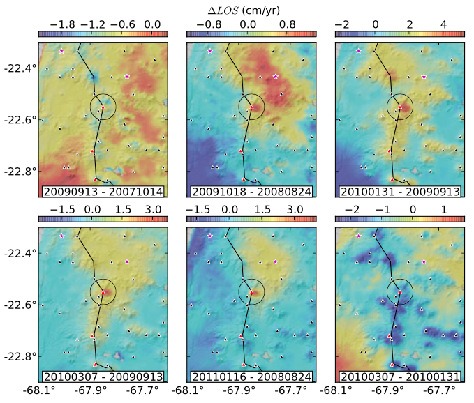 |
Selection of interferograms showing uplift at Putana Volcano (located within the black circular marker). Black triangles are volcanic edifices from de Silva and Francis [1991], red triangles are Holocene volcanos from Siebert et al. [2011], and purple stars mark the location of geyser fields. The deformation is persistent on various dates and similar amplitude uplift signals are not apparent on neighboring edifices, suggesting a non-atmospheric origin. Based on this collection of interferograms, and local seismic data, we ascertain the deformation was short lived and occurred sometime between 13 September 2009 and 31 January 2010. From: Henderson and Pritchard 2013. |
||
Reference List: Henderson and Pritchard 2013.
Full References:
Henderson, S. T., and M. E. Pritchard, 2013. Decadal volcanic deformation in the central Andes volcanic zone revealed by InSAR time series. Geochemistry Geophysics Geosystems, 14: 1358–1374. https://doi.org/10.1002.ggge.20074
There is no Emissions History data available for Putana.
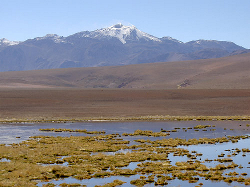
 The complicated structure of Volcán Putana can be seen in this view from the NW. The volcanic complex was formed almost entirely by lava effusion. Thick viscous lava flows have issued from both summit and flank vents. Early lava flows mantling an older Pleistocene edifice were longer, whereas the younger flows are short and stubby, rarely exceeding 3 km in length. A road leads to a sulfur mine near the summit (extreme right).
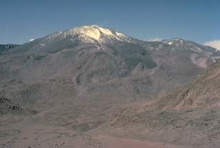 Volcán Putana, seen here from the NW, is part of large, roughly N-S-trending volcanic complex that was formed almost exclusively by lava effusion. Vigorous fumarolic activity is visible for many km from the summit of Putana volcano and sulfur is mined in the summit region. The main edifice consists of accumulated postglacial lava flows mantling an older pre-Holocene volcano. The youngest lava flows are viscous and rarely extend more than 3 km. Little is known of the eruptive history of this volcano.
 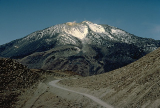 A road leads to a sulfur mine near the summit of 5890-m-high Putana volcano. Active fumaroles can be seen above several vents in the hydrothermally altered summit region. The main edifice was constructed primarily by lava effusion, with late-stage eruptions producing an accumulated pile of short, thick lava flows. Flank vents have also emitted fresh-looking lava flows.
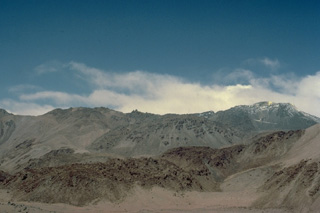
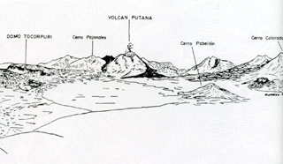 The area around Volcán Putana is seen from the west in this sketch. Putana is part of a large, roughly N-S-trending volcanic complex that covers an area of 600 km2. Vigorous fumarolic activity (depicted in this sketch) is visible at the 5890-m-high summit of Putana volcano from long distances. The main edifice consists of accumulated postglacial dacitic lava domes and flows mantling an older pre-Holocene volcano. Young dark-colored flows in this sketch descend the western flanks of the volcano.
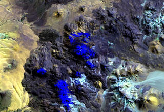 Putana volcano, also known as Jorgencal or Machuca, lies in the center of this Landsat image. Snow-covered areas are deep blue in this image of the N-S-trending volcanic complex, which covers an area of 600 km2. The main edifice consists of accumulated postglacial dacitic lava domes and flows mantling an older pre-Holocene volcano. The youngest basaltic andesite lava flows are viscous and rarely extend more than 3 km. The prominent fan-shaped lava flow at the upper left originated from a flank vent.
 Volcán Putana, seen here from the west, shows vigorous fumarolic activity at its 5890-m-high summit. Snow forming a thin diagonal line below and to the right of the summit marks a road leading to a sulfur-mining operation at the summit of the volcano. Putana is also known as Jorgencal or Machuca and is part of a large, roughly N-S-trending volcanic complex that covers an area of 600 km2 along the Chile-Bolivia border. Postglacial dacitic lava domes and short, thick lava flows form the main edifice.
The maps shown below have been scanned from the GVP map archives and include the volcano on this page. Clicking on the small images will load the full 300 dpi map. Very small-scale maps (such as world maps) are not included. The maps database originated over 30 years ago, but was only recently updated and connected to our main database. We welcome users to tell us if they see incorrect information or other problems with the maps; please use the Contact GVP link at the bottom of the page to send us email.
There are no samples for Putana in the Smithsonian's NMNH Department of Mineral Sciences Rock and Ore collection.
| Copernicus Browser | The Copernicus Browser replaced the Sentinel Hub Playground browser in 2023, to provide access to Earth observation archives from the Copernicus Data Space Ecosystem, the main distribution platform for data from the EU Copernicus missions. |
| MIROVA | Middle InfraRed Observation of Volcanic Activity (MIROVA) is a near real time volcanic hot-spot detection system based on the analysis of MODIS (Moderate Resolution Imaging Spectroradiometer) data. In particular, MIROVA uses the Middle InfraRed Radiation (MIR), measured over target volcanoes, in order to detect, locate and measure the heat radiation sourced from volcanic activity. |
| MODVOLC Thermal Alerts | Using infrared satellite Moderate Resolution Imaging Spectroradiometer (MODIS) data, scientists at the Hawai'i Institute of Geophysics and Planetology, University of Hawai'i, developed an automated system called MODVOLC to map thermal hot-spots in near real time. For each MODIS image, the algorithm automatically scans each 1 km pixel within it to check for high-temperature hot-spots. When one is found the date, time, location, and intensity are recorded. MODIS looks at every square km of the Earth every 48 hours, once during the day and once during the night, and the presence of two MODIS sensors in space allows at least four hot-spot observations every two days. Each day updated global maps are compiled to display the locations of all hot spots detected in the previous 24 hours. There is a drop-down list with volcano names which allow users to 'zoom-in' and examine the distribution of hot-spots at a variety of spatial scales. |
|
WOVOdat
Single Volcano View Temporal Evolution of Unrest Side by Side Volcanoes |
WOVOdat is a database of volcanic unrest; instrumentally and visually recorded changes in seismicity, ground deformation, gas emission, and other parameters from their normal baselines. It is sponsored by the World Organization of Volcano Observatories (WOVO) and presently hosted at the Earth Observatory of Singapore.
GVMID Data on Volcano Monitoring Infrastructure The Global Volcano Monitoring Infrastructure Database GVMID, is aimed at documenting and improving capabilities of volcano monitoring from the ground and space. GVMID should provide a snapshot and baseline view of the techniques and instrumentation that are in place at various volcanoes, which can be use by volcano observatories as reference to setup new monitoring system or improving networks at a specific volcano. These data will allow identification of what monitoring gaps exist, which can be then targeted by remote sensing infrastructure and future instrument deployments. |
| Volcanic Hazard Maps | The IAVCEI Commission on Volcanic Hazards and Risk has a Volcanic Hazard Maps database designed to serve as a resource for hazard mappers (or other interested parties) to explore how common issues in hazard map development have been addressed at different volcanoes, in different countries, for different hazards, and for different intended audiences. In addition to the comprehensive, searchable Volcanic Hazard Maps Database, this website contains information about diversity of volcanic hazard maps, illustrated using examples from the database. This site is for educational purposes related to volcanic hazard maps. Hazard maps found on this website should not be used for emergency purposes. For the most recent, official hazard map for a particular volcano, please seek out the proper institutional authorities on the matter. |
| IRIS seismic stations/networks | Incorporated Research Institutions for Seismology (IRIS) Data Services map showing the location of seismic stations from all available networks (permanent or temporary) within a radius of 0.18° (about 20 km at mid-latitudes) from the given location of Putana. Users can customize a variety of filters and options in the left panel. Note that if there are no stations are known the map will default to show the entire world with a "No data matched request" error notice. |
| UNAVCO GPS/GNSS stations | Geodetic Data Services map from UNAVCO showing the location of GPS/GNSS stations from all available networks (permanent or temporary) within a radius of 20 km from the given location of Putana. Users can customize the data search based on station or network names, location, and time window. Requires Adobe Flash Player. |
| DECADE Data | The DECADE portal, still in the developmental stage, serves as an example of the proposed interoperability between The Smithsonian Institution's Global Volcanism Program, the Mapping Gas Emissions (MaGa) Database, and the EarthChem Geochemical Portal. The Deep Earth Carbon Degassing (DECADE) initiative seeks to use new and established technologies to determine accurate global fluxes of volcanic CO2 to the atmosphere, but installing CO2 monitoring networks on 20 of the world's 150 most actively degassing volcanoes. The group uses related laboratory-based studies (direct gas sampling and analysis, melt inclusions) to provide new data for direct degassing of deep earth carbon to the atmosphere. |
| Large Eruptions of Putana | Information about large Quaternary eruptions (VEI >= 4) is cataloged in the Large Magnitude Explosive Volcanic Eruptions (LaMEVE) database of the Volcano Global Risk Identification and Analysis Project (VOGRIPA). |
| EarthChem | EarthChem develops and maintains databases, software, and services that support the preservation, discovery, access and analysis of geochemical data, and facilitate their integration with the broad array of other available earth science parameters. EarthChem is operated by a joint team of disciplinary scientists, data scientists, data managers and information technology developers who are part of the NSF-funded data facility Integrated Earth Data Applications (IEDA). IEDA is a collaborative effort of EarthChem and the Marine Geoscience Data System (MGDS). |

