According to the Buenos Aires VAAC a diffuse cloud of resuspended ash from Descabezado Grande was visible in a satellite data on 8 March.
Source: Buenos Aires Volcanic Ash Advisory Center (VAAC)
New fumarole in main crater
Fumarolic activity was observed on the morning of 19 March. A white plume was rising from the summit crater during the 3 hours the observer was on Nevados de Chillán Volcano, 160 km to the S. The only recorded eruption at Descabezado Grande, in 1932, was from a crater at its NE foot. Weak fumarolic activity has been reported on the W slope at about 3,500 m, but none had previously been observed in the main crater.
Information Contacts: H. Moreno R., Univ. de Chile, Santiago.
According to the Buenos Aires VAAC a diffuse cloud of resuspended ash from Descabezado Grande was visible in a satellite data on 8 March.
Source: Buenos Aires Volcanic Ash Advisory Center (VAAC)
OVDAS-SERNAGEOMIN reported that during 1-28 February seismicity increased at Descabezado Grande, in the Laguna del Maule volcanic complex area. There were 127 earthquakes detected, with magnitudes 1.7 or less, mostly comprised of volcano-tectonic earthquakes. The seismic swarms were associated with deformation and considered to be at a high level. On 8 March the Alert Level was raised to Yellow.
Source: Servicio Nacional de Geología y Minería (SERNAGEOMIN)
Reports are organized chronologically and indexed below by Month/Year (Publication Volume:Number), and include a one-line summary. Click on the index link or scroll down to read the reports.
New fumarole in main crater
Fumarolic activity was observed on the morning of 19 March. A white plume was rising from the summit crater during the 3 hours the observer was on Nevados de Chillán Volcano, 160 km to the S. The only recorded eruption at Descabezado Grande, in 1932, was from a crater at its NE foot. Weak fumarolic activity has been reported on the W slope at about 3,500 m, but none had previously been observed in the main crater.
Information Contacts: H. Moreno R., Univ. de Chile, Santiago.
This compilation of synonyms and subsidiary features may not be comprehensive. Features are organized into four major categories: Cones, Craters, Domes, and Thermal Features. Synonyms of features appear indented below the primary name. In some cases additional feature type, elevation, or location details are provided.
Synonyms |
||||
| Descabezado del Maule | ||||
Cones |
||||
| Feature Name | Feature Type | Elevation | Latitude | Longitude |
| Chivato, Volcán | Cone | 2080 m | 35° 29' 0" S | 70° 51' 0" W |
| Manantial Pelado | Stratovolcano | 2850 m | 35° 30' 0" S | 70° 49' 0" W |
| Palizada, Volcán | Stratovolcano | 2640 m | 35° 32' 0" S | 70° 49' 0" W |
| Rajaderas, Volcán | Stratovolcano | 3000 m | 35° 32' 0" S | 70° 43' 0" W |
Craters |
||||
| Feature Name | Feature Type | Elevation | Latitude | Longitude |
| Mulas, Alto de las | Fissure vent | 2550 m | 35° 33' 0" S | 70° 48' 0" W |
Domes |
||||
| Feature Name | Feature Type | Elevation | Latitude | Longitude |
|
Lengua de Vulcano
Mondaca |
Dome | 2048 m | 35° 27' 51" S | 70° 48' 1" W |
|
|
||||||||||||||||||||||||
There is data available for 1 confirmed Holocene eruptive periods.
1932 Jun 5 ± 5 days - 1933 Confirmed Eruption Max VEI: 3
| Episode 1 | Eruption Episode | Upper NNE slope | |||||||||||||||||||||||||||||||||||||||
|---|---|---|---|---|---|---|---|---|---|---|---|---|---|---|---|---|---|---|---|---|---|---|---|---|---|---|---|---|---|---|---|---|---|---|---|---|---|---|---|---|
| 1932 Jun 5 ± 5 days - 1933 | Evidence from Observations: Reported | |||||||||||||||||||||||||||||||||||||||
|
List of 6 Events for Episode 1 at Upper NNE slope
| ||||||||||||||||||||||||||||||||||||||||
There is no Deformation History data available for Descabezado Grande.
There is no Emissions History data available for Descabezado Grande.
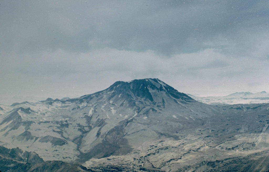
 The summit of Descabezado Grande volcano is truncated by a 1.4-km-wide, ice-filled summit crater, giving rise to its name, which means "Large Headless Volcano." The only historical eruption of this late-Pleistocene to Holocene volcano, seen here from the west, occurred in 1932 from an upper NNE-flank vent. The 1932 crater lies out of view below and to the left of the notch at the left side of the summit crater.
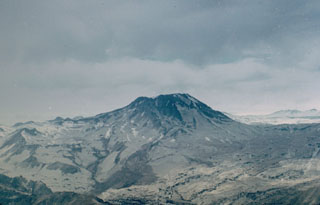 Volcán Descabezado Grande, seen here from the west, is a late-Pleistocene to Holocene stratovolcano with a 1.4-km-wide ice-filled summit crater. The Holocene Alto de las Mulas fissure on the lower NW flank (out of view to the left) produced young rhyodacitic lava flows. A lateral crater formed on the upper NNE flank in 1932, shortly after the end of the major 1932 eruption from nearby Quizapú volcano. This was the site of the only historical eruption of Descabezado Grande.
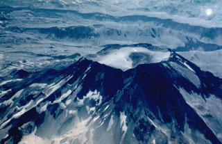
 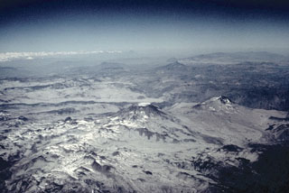 Descabezado Grande (center) and Cerro Azul (middle right), seen here from the NW, are the most prominent features of a large volcanic field. The most active of the two large stratovolcanoes is 3810-m-high Cerro Azul. Quizapú, a vent that formed in 1846 on the northern flank of Cerro Azul, was the source of one of the world's largest explosive eruptions of the 20th century in April 1932. The eruption created a 600-700 m wide crater and ejected 9.5 cu km of dacitic tephra. The only historical eruption of Descabezado Grande took place later in 1932.
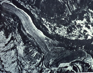 The 2048-m-high Mondaca lava dome (bottom center) produced a large youthful rhyodacitic lava flow that traveled north and dammed the Rio Lontue, eventually reaching 7 km to the NW (upper right). This eruption may have taken place during historical time, possibly during the 19th century. The solitary small Mondaca lava dome is located NNW of the Descabezado volcano complex and west of the Calabozos caldera.
 The maps shown below have been scanned from the GVP map archives and include the volcano on this page. Clicking on the small images will load the full 300 dpi map. Very small-scale maps (such as world maps) are not included. The maps database originated over 30 years ago, but was only recently updated and connected to our main database. We welcome users to tell us if they see incorrect information or other problems with the maps; please use the Contact GVP link at the bottom of the page to send us email.
There are no samples for Descabezado Grande in the Smithsonian's NMNH Department of Mineral Sciences Rock and Ore collection.
| Copernicus Browser | The Copernicus Browser replaced the Sentinel Hub Playground browser in 2023, to provide access to Earth observation archives from the Copernicus Data Space Ecosystem, the main distribution platform for data from the EU Copernicus missions. |
| MIROVA | Middle InfraRed Observation of Volcanic Activity (MIROVA) is a near real time volcanic hot-spot detection system based on the analysis of MODIS (Moderate Resolution Imaging Spectroradiometer) data. In particular, MIROVA uses the Middle InfraRed Radiation (MIR), measured over target volcanoes, in order to detect, locate and measure the heat radiation sourced from volcanic activity. |
| MODVOLC Thermal Alerts | Using infrared satellite Moderate Resolution Imaging Spectroradiometer (MODIS) data, scientists at the Hawai'i Institute of Geophysics and Planetology, University of Hawai'i, developed an automated system called MODVOLC to map thermal hot-spots in near real time. For each MODIS image, the algorithm automatically scans each 1 km pixel within it to check for high-temperature hot-spots. When one is found the date, time, location, and intensity are recorded. MODIS looks at every square km of the Earth every 48 hours, once during the day and once during the night, and the presence of two MODIS sensors in space allows at least four hot-spot observations every two days. Each day updated global maps are compiled to display the locations of all hot spots detected in the previous 24 hours. There is a drop-down list with volcano names which allow users to 'zoom-in' and examine the distribution of hot-spots at a variety of spatial scales. |
|
WOVOdat
Single Volcano View Temporal Evolution of Unrest Side by Side Volcanoes |
WOVOdat is a database of volcanic unrest; instrumentally and visually recorded changes in seismicity, ground deformation, gas emission, and other parameters from their normal baselines. It is sponsored by the World Organization of Volcano Observatories (WOVO) and presently hosted at the Earth Observatory of Singapore.
GVMID Data on Volcano Monitoring Infrastructure The Global Volcano Monitoring Infrastructure Database GVMID, is aimed at documenting and improving capabilities of volcano monitoring from the ground and space. GVMID should provide a snapshot and baseline view of the techniques and instrumentation that are in place at various volcanoes, which can be use by volcano observatories as reference to setup new monitoring system or improving networks at a specific volcano. These data will allow identification of what monitoring gaps exist, which can be then targeted by remote sensing infrastructure and future instrument deployments. |
| Volcanic Hazard Maps | The IAVCEI Commission on Volcanic Hazards and Risk has a Volcanic Hazard Maps database designed to serve as a resource for hazard mappers (or other interested parties) to explore how common issues in hazard map development have been addressed at different volcanoes, in different countries, for different hazards, and for different intended audiences. In addition to the comprehensive, searchable Volcanic Hazard Maps Database, this website contains information about diversity of volcanic hazard maps, illustrated using examples from the database. This site is for educational purposes related to volcanic hazard maps. Hazard maps found on this website should not be used for emergency purposes. For the most recent, official hazard map for a particular volcano, please seek out the proper institutional authorities on the matter. |
| IRIS seismic stations/networks | Incorporated Research Institutions for Seismology (IRIS) Data Services map showing the location of seismic stations from all available networks (permanent or temporary) within a radius of 0.18° (about 20 km at mid-latitudes) from the given location of Descabezado Grande. Users can customize a variety of filters and options in the left panel. Note that if there are no stations are known the map will default to show the entire world with a "No data matched request" error notice. |
| UNAVCO GPS/GNSS stations | Geodetic Data Services map from UNAVCO showing the location of GPS/GNSS stations from all available networks (permanent or temporary) within a radius of 20 km from the given location of Descabezado Grande. Users can customize the data search based on station or network names, location, and time window. Requires Adobe Flash Player. |
| DECADE Data | The DECADE portal, still in the developmental stage, serves as an example of the proposed interoperability between The Smithsonian Institution's Global Volcanism Program, the Mapping Gas Emissions (MaGa) Database, and the EarthChem Geochemical Portal. The Deep Earth Carbon Degassing (DECADE) initiative seeks to use new and established technologies to determine accurate global fluxes of volcanic CO2 to the atmosphere, but installing CO2 monitoring networks on 20 of the world's 150 most actively degassing volcanoes. The group uses related laboratory-based studies (direct gas sampling and analysis, melt inclusions) to provide new data for direct degassing of deep earth carbon to the atmosphere. |
| Large Eruptions of Descabezado Grande | Information about large Quaternary eruptions (VEI >= 4) is cataloged in the Large Magnitude Explosive Volcanic Eruptions (LaMEVE) database of the Volcano Global Risk Identification and Analysis Project (VOGRIPA). |
| EarthChem | EarthChem develops and maintains databases, software, and services that support the preservation, discovery, access and analysis of geochemical data, and facilitate their integration with the broad array of other available earth science parameters. EarthChem is operated by a joint team of disciplinary scientists, data scientists, data managers and information technology developers who are part of the NSF-funded data facility Integrated Earth Data Applications (IEDA). IEDA is a collaborative effort of EarthChem and the Marine Geoscience Data System (MGDS). |

