SERNAGEOMIN reported that during 1-14 May seismicity from Llaima had decreased to moderate levels. Small white fumaroles that rose from the main crater were seen through web cameras. The Alert Level was lowered to Yellow Level 3 on a three-color scale.
Source: Servicio Nacional de Geología y Minería (SERNAGEOMIN)
Substantial April 2009 eruption had three lava flows
A new eruptive episode began at Llaima on 1 July 2008 (BGVN 33:08) when a lava flow was seen moving down the W flank and sporadic ash explosions originated from the summit area. Activity continued through most of July, but after an episode of Strombolian activity on 26-27 July only fumarolic emissions were reported by scientists from the Southern Andes Volcanological Observatory (OVDAS) of the Chile National Service of Geology and Mining (SERNAGEOMIN). Additional ash explosions began in the second half of August before the volcano quieted again after 3 September (BGVN 33:08).
During an overflight on 12 September OVDAS scientists observed diffuse gas-and-steam emissions from the external edges of the nested craters in the main crater. Observers in Melipeuco (~ 17 km SSE) reported sporadic gas-and-steam emissions from the main crater the following week of 13-22 September. During another overflight on 21 September, steaming was noted from the NE and W flanks.
OVDAS reported that from 19 to 25 November 2008, observers in the area reported weak and sporadic emissions of water vapor concentrated around the two small craters of the paired pyroclastic cones nested inside the main crater. During this period there had been a slight increase both in the energy and number of long-period earthquakes. Seismic instrumentation was located 20 km from the volcano. A few episodes of short duration tremor (averaging 20 RSAM units) along with weak and occasional steam emissions suggested that the seismicity was of superficial origin.
On 11 December two small debris avalanches descended the W flank through an ice channel. Fumarolic activity gradually increased after mid-December; on 22 December there were two weak ash emissions. Meltwater from heavy snowfall on the preceding day was probably responsible for this phreatomagmatic activity.
On 3 January 2009 the two monitoring cameras captured a total of 37 phreatomagmatic explosions over about 14 hours; the plumes of gases and tephra rose 100 m before becoming disconnected from their source. The emissions came from three distinct points within the intra-crater cone. On two occasions spatters of lava impacted the slope of the intra-crater cone and its base. Rockfalls also descended the SE flank of Pichillaima cone, Llaima's secondary summit.
On 2-3 April 2009, OVDAS reported that seismicity from Llaima increased in frequency and amplitude and evolved into continuous tremor. Steam plumes with small amounts of ash were emitted. Late on 3 April, observers reported incandescence from the main crater. Weak Strombolian explosions were produced in the N cone inside the crater. Five settlements were put on alert, including Vilcun and Curacautin, where late on 4 April evacuations began due to lava and ash eruptions. That day, rhythmic Strombolian explosions occurred in the main crater from two nested pyroclastic cones. Incandescent tephra was ejected ~ 700 m above the crater. The Alert Level was raised to Red, the highest state, and the surrounding Conguillio National Park was closed.
The Oficina Nacional de Emergencia, Ministerio del Interior, (ONEMI) reported that, on 4 April, fine ash fell in Lago Lake in the Conguillío National Park and a lava flow 1 km long traveled W towards the Calbuco River. Access to local parks was restricted and 12 people self-evacuated. Later that day, authorities evacuated 71 additional people in high-risk areas, mainly due to the potential for lahars along the Calbuco River and other waterways swollen with volcanic ash.
OVDAS reported that Strombolian activity continued on 5 April (figure 29). A dark gray ash plume drifted E; heavy ashfall was reported in Lago Verde. A lahar traveled NNE down the Captrén River and lava continued to travel down the W flank. On 6 April continuous explosions were observed from Melipeuco (17 km SSE). Lahars again traveled down the Captrén River. Occasionally, gas-and-ash plumes were seen which drifted E and ash fell in areas to the E. Heavy ashfall and lapilli up to 1.5 cm in diameter fell in the National Park areas between Conguillio Lake 10 km ENE, and the Arcoiris Lake less than 10 km ENE.
 |
Figure 29. Photo of Strombolian activity from the intra-crater cones at Llaima on 5 April 2009. Courtesy of Reuters. |
After 6 April activity declined quickly until reaching a low level characterized by small amounts of ash emissions. On 7 April, gas and ash emitted from multiple points formed a plume that rose ~ 1 km above the summit and drifted NE. The flanks were covered with bombs, lapilli, and ash. An overflight on 7 April observed the main crater completely obscured by a large pyroclastic cone with four inactive craters. Two lava flows descended the W flank. The more southerly lava flow was about 4.5 km long and melted part of the glacier, causing a lahar towards the Calbuco River. The more northerly lava flow was similar in length, and branched off into two 1-km-long flows; it also caused a lahar. On the NE flank, a lava flow that originated from the base of the pyroclastic cone caused lahars that descended into the valley between Curacautín (30 km NNW) and the Conguillío National Park.
During 7-10 April, there was intermittent incandescence from a lava flow at the SW base of the pyroclastic cone. Incandescent blocks originating from the lava flow descended W. On 8 April, gasses emitted from multiple points on the pyroclastic cone formed a plume that drifted NE. Preliminary calculations indicated that the height of the pyroclastic cone exceeded the top of the main crater by ~ 70 m, making the new summit elevation 3,240 m. During 9-10 and 13-14 April, gas and steam plumes rose from the pyroclastic cone; on 14 April, fumarolic activity from the pyroclastic cone was again noted. On 16 April, NASA's Earth Observing-1 satellite passed overhead and documented areas of ash-covered snow W of the summit.
On 24 April ash plumes originating from an area ~ 700 m down the E flank rose ~ 500 m and drifted E. Steam emissions that accompanied the ash plumes indicated that the point of activity came from underneath the glacier. The activity lasted about 1.5 hours. During 28 April-11 May, OVDAS reported sporadic incandescence from an area in the SW part of the main crater. Blocks occasionally rolling down the W flank were seen on a web camera.
During 5-11 May, tephra was ejected from an area on the E flank and, during the night, incandescence originated from this area. During the daytime, observers reported that an almost continuous orange brown plume rose ~ 200 m. Sporadic incandescence also came from an area in the SW part of Llaima's main crater, corresponding to a small active outcrop of lava. Steam plumes rose from the same area continued until 18 May. MODVOLC data reflects the dramatic thermal activity between 4 April and 14 April.
On 26 May 2009, after a period of unusually heavy rain, a 500 m-long fissure on Lliama's the upper E flank began to emit dense steam clouds. On the following day, small amounts of ash were observed mixed in with the water vapor, and on 28 May both the amount of vapor and the ash content increased. On 1 June, after further bad weather, the energy of the intermittent emissions along the fissure further increased. A powerful phreatic eruption began at 1120. The eruption ceased by 1200, and during that afternoon only one small subsequent eruption was observed. Since the phreatic fissure eruptions began, seismicity had remained at normal levels but the number and energy of LP (long period) earthquakes had increased.
During an overflight of Llaima on 1 June 2009 observers reported a 2 km2 area with an elevated temperature on the E flank. Several small areas emitted gas, and a small cone was forming ~ 800 m below the crater. The observers also saw an E-trending, ~ 300m-long fissure located 200 m from the main crater's rim. Brown ash and steam plumes were emitted from different areas of the fissure. The irregularly-shaped summit crater had a few weak fumaroles. During 5-8 June, OVDAS reported increased seismic tremor. Incandescence from an area in the SW part of Llaima's main crater continued to correspond to a small active outcrop of lava. On 6 June, incandescence emanated from a small point along the E-flank fissure. Gas and steam was emitted from an area W of the main crater. The camera in Melipueco again showed glow on the NW inner margin of the main crater during 9-16 June, and occasional steam emissions with minor amounts of ash were also seen from the E flank. From 12 June on there was no evidence of lateral or summit eruption, although inclement weather masked views of the mountain.
An OVDAS report dated 3 July 2009 indicated that seismicity remained similar to the previous week, although there was an increase in the number of low amplitude long-period earthquakes, up to 40/hour. However, they detected two to three higher-energy earthquakes per day; along with weak tremor. A continuing increase of the long-period type earthquakes observed during the previous three days was interpreted to indicate the potential for an eruptive event. Only steam was visible in sectors where previously there have been lava flows.
On 14 November 2009, cameras operated by OVDAS showed steam-and-gas plumes rising from the main crater and E flank. These emissions continued until 1 December. Although seismicity generally decreased, a new type of long-period, low-frequency earthquake was detected. An overflight on 4 December revealed fumarolic activity and some SO2 emissions coming mainly from fissures on the N crater wall and outer E and W flanks.
During 20 January-9 February 2010, cameras showed steam-and-gas plumes rising from the main crater. Seismic signals (tremor and volcano-tectonic earthquakes) had characteristics that indicated fluid movement. On 22 January 2010, OVDAS reported that seismicity had decreased during the previous few weeks to background levels.
OVDAS reported that on 4 March 2010 seismicity increased. During an overflight that same day, scientists observed emissions of gas and steam from the main crater. Photographs were compared to those taken on 21 February and showed no significant changes in morphology. The rate of sulfur dioxide emissions had increased, however. Scientists also noted deposits from a large rockfall along with fracturing of the glacier, especially on the upper N and NW flanks. During 5-22 March seismicity generally decreased to levels characteristic prior to the 27 February earthquake; however a significant number of earthquakes that indicated fluid movement in the volcano continued to be registered. Gas-and-steam plumes rose 100 m from their source.
On 15 April 2010 seismicity increased and tremor was detected; however, OVDAS reported that during 1-14 May seismicity decreased to moderate levels. Small white fumaroles that rose from the main crater were seen through web cameras.
Information Contacts: Observatorio Volcanológico de los Andes del Sur (OVDAS), Observatorio Volcanológico de los Andes del Sur-Servico Nacional de Geologia y Mineria; Southern Andes Volcanological Observatory-National Geology and Mining Service (SERNAGEOMIN), Avda Sta María No. 0104, Santiago, Chile; Oficina Nacional de Emergencia - Ministerio del Interior (ONEMI), Ministerio del Interior, Chile (URL: http://www.onemi.cl/); NASA Earth Observatory (URL: http://earthobservatory.nasa.gov/); ; Hawai'i Institute of Geophysics and Planetology (HIGP) Thermal Alerts System, School of Ocean and Earth Science and Technology (SOEST), Univ. of Hawai'i, 2525 Correa Road, Honolulu, HI 96822, USA (URL: http://modis.higp.hawaii.edu/); Reuters (URL: http://www.reuters.com/).
2010: January
| February
| March
| April
| May
2009: January
| April
| May
| June
| December
2008: January
| February
| March
| April
| June
| July
| August
| September
| December
2007: May
| August
| December
2003: April
SERNAGEOMIN reported that during 1-14 May seismicity from Llaima had decreased to moderate levels. Small white fumaroles that rose from the main crater were seen through web cameras. The Alert Level was lowered to Yellow Level 3 on a three-color scale.
Source: Servicio Nacional de Geología y Minería (SERNAGEOMIN)
On 26 April, SERNAGEOMIN reported that seismicity from Llaima had increased on 15 April and that tremor was detected. The Alert Level was raised to Yellow, (Level 4) on a three-color scale.
Source: Servicio Nacional de Geología y Minería (SERNAGEOMIN)
SERNAGEOMIN reported that seismicity from Llaima had generally decreased during 5-22 March, to levels detected prior to an earthquake on 27 February. A significant number of earthquakes that indicated fluid movement in the volcano continued to be registered. Gas-and-steam plumes rose 100 m from their source. The Alert Level was lowered to Yellow, (Level 3) on a three-color scale.
Source: Servicio Nacional de Geología y Minería (SERNAGEOMIN)
SERNAGEOMIN reported that on 4 March seismicity from Llaima increased. During an overflight that same day, scientists observed emissions of gas and steam from the main crater. Images taken that day were compared to those taken on 21 February and showed no significant changes in morphology. The rate of sulfur dioxide emissions had increased, however. Scientists also noted deposits from a large rockfall along with fracturing of the glacier, especially on the upper N and NW flanks. Those observations in addition to the increased seismicity prompted SERNAGEOMIN to raise the Alert Level to Yellow, Level 4.
Source: Servicio Nacional de Geología y Minería (SERNAGEOMIN)
Cameras operated by OVDAS-SERNAGEOMIN showed steam-and-gas plumes rising from Llaima's main crater during 20 January-9 February. Seismic signals (tremor and volcano-tectonic earthquakes) had characteristics that indicated fluid movement within the volcano's conduits. The Alert Level was raised to Yellow, Level 3. SERNAGEOMIN recommended that people stay at least 4 km away from the main crater.
Source: Servicio Nacional de Geología y Minería (SERNAGEOMIN)
On 22 January, SERNAGEOMIN reported that seismicity from Llaima had decreased during the previous few weeks to background levels. The Alert Level was lowered to Green, (Level 2) on a three-color scale.
Source: Servicio Nacional de Geología y Minería (SERNAGEOMIN)
Cameras operated by OVDAS-SERNAGEOMIN showed steam-and-gas plumes rising from Llaima's main crater and E flank during 14 November-1 December. Although seismicity generally decreased, a new type of long-period, low-frequency earthquake was detected. An overflight on 4 December revealed fumarolic activity and some sulfur dioxide emissions coming mainly from fissures on the N crater wall and outer E and W flanks. The Alert Level was raised to Yellow, Level 3. Activity last noted in the Weekly Volcanic Activity Report from 9-16 June was described as occasional steam emissions with minor amounts of ash rising from the E flank.
Source: Servicio Nacional de Geología y Minería (SERNAGEOMIN)
The camera in Melipueco used by OVDAS-SERNAGEOMIN to monitor Llaima again showed glow on the NW inner margin of the main crater during 9-16 June. Occasional steam emissions with minor amounts of ash were also seen from the E flank. Seismic tremor has also increased since 5 June. The Alert Level remained at Yellow.
Source: Servicio Nacional de Geología y Minería (SERNAGEOMIN)
SERNAGEOMIN reported that during 5-8 June incandescence from an area in the SW part of Llaima's main crater corresponded to a small active "outcrop of lava." On 6 June, incandescence emanated from a small point along the E-flank fissure. Gas and steam was emitted from an area W of the main crater. The Volcano Alert Level remained at Yellow.
Source: Servicio Nacional de Geología y Minería (SERNAGEOMIN)
SERNAGEOMIN reported that scientists aboard an overflight of Llaima on 1 June observed a 2-square-kilometer area with an elevated temperature on the E flank. Several small areas emitted gas and a small cone was forming about 800 m below the crater. They also saw an E-W trending fissure 200 m from the rim of the main crater that was about 300 m long. Brown ash and steam plumes were emitted from different areas of the fissure. The irregularly-shaped summit crater had a few weak fumaroles. The Volcano Alert Level remained at Yellow.
Source: Servicio Nacional de Geología y Minería (SERNAGEOMIN)
During 12-18 May, SERNAGEOMIN reported sporadic incandescence from an area in the SW part of Llaima's main crater, corresponding to a small active "outcrop of lava." Steam plumes rose from the same area. The Volcano Alert Level remained at Yellow.
Source: Servicio Nacional de Geología y Minería (SERNAGEOMIN)
During 28 April-11 May, SERNAGEOMIN reported sporadic incandescence from an area in the SW part of Llaima's main crater, corresponding to a small outcrop of lava. Blocks occasionally rolling down the W flank were seen on a web camera. During 5-11 May, tephra was ejected from an area on the E flank and, during the night, incandescence originated from this area. During the daytime, observers reported that an almost continuous orange brown plume rose 200 m. The Volcano Alert Level remained at Yellow.
Source: Servicio Nacional de Geología y Minería (SERNAGEOMIN)
SERNAGEOMIN reported that on 24 April ash plumes originating from an area about 700 m down the E flank of Llaima rose 500 m and drifted E. Steam emissions that accompanied the ash plumes indicated that the point of activity came from underneath the glacier. The activity lasted about 1.5 hours. The Volcano Alert Level remained at Yellow.
Source: Servicio Nacional de Geología y Minería (SERNAGEOMIN)
On 8 April, SERNAGEOMIN reported that, after 74 hours of a vigorous Strombolian eruption from Llaima and accompanying lava flow emissions, activity declined quickly on 6 April until reaching a low level characterized by small amounts of ash emissions. On 7 April, weak emissions of gas and ash were observed. An overflight revealed that the main crater was completely obscured by a large pyroclastic cone with four inactive craters. Sulfur dioxide and hydrochloric gasses were emitted. Two lava flows descended the W flank. The more southerly lava flow was about 4.5 km long and melted part of the glacier, causing a lahar to travel towards the Calbuco River. The more northerly lava flow was similar in length, and branched off into two 1-km-long flows. It too caused a lahar. On the NE flank, a lava flow that originated from the base of the pyroclastic cone caused lahars that descended into the valley between Curacautín (30 km NNW) and the Conguillío National Park.
During 7-10 April, intermittent incandescence from a lava flow at the SW base of the pyroclastic cone was observed. Incandescent blocks originating from the lava flow descended W. On 8 April, gasses emitted from multiple points on the pyroclastic cone formed a plume that drifted NE. Preliminary calculations indicated that the height of the pyroclastic cone exceeded the top of the main crater by 70 m, making the summit elevation 3,240 m a.s.l. During 9-10 and 13-14 April, gas and steam plumes rose from the pyroclastic cone; views were obscured by clouds on 11 and 12 April. On 14 April, fumarolic activity from the pyroclastic cone was again noted. The Volcano Alert Level remained at Red.
Source: Servicio Nacional de Geología y Minería (SERNAGEOMIN)
During 2-3 April, SERNAGEOMIN reported that seismicity from Llaima increased in frequency and amplitude and evolved into continuous seismic tremor. Steam plumes with small amounts of ash were emitted. Late in the day on 3 April, observers reported incandescence from the main crater. Weak Strombolian explosions were produced by the N cone inside the crater. On 4 April, Strombolian activity and rhythmic explosions in the main crater originated from two nested pyroclastic cones. Incandescent tephra was ejected 700 m above the crater. The Alert Level was raised to Red. ONEMI reported that fine ash fell in Verde Lake in the Conguillío National Park (a 608 square kilometer park containing Llaima) and a lava flow 1 km long traveled W towards the Calbuco River. Access to local parks was restricted and twelve people self-evacuated. Later that day, authorities ordered an evacuation for people in high-risk areas, mainly due to the potential for lahars along the Calbuco River. According to news articles, 71 people evacuated.
SERNAGEOMIN reported that Strombolian activity continued on 5 April. A dark gray ash plume drifted E; heavy ashfall was reported in Lago Verde. A lahar traveled down the Captrén River (NNE) and lava continued to travel down the W flank. On 6 April, poor weather mostly prevented visual observations, but continuous explosions were reported from Melipeuco (about 17 km SSE). Lahars again traveled down the Captrén River. Occasionally, gas-and-ash plumes were seen and drifted E; ash fell in areas E. Heavy ashfall and lapilli up to 1.5 cm in diameter fell in areas between Conguillio Lake (about 10 km ENE, in Conguillío National Park) and the Arcoiris Lake (less than 10 km ENE, in Conguillío National Park). On 7 April, gas and ash emitted from multiple points formed a plume that rose 1 km above the summit and drifted NE. The flanks of the volcano were covered with bombs, lapilli, and ash.
Sources: Servicio Nacional de Geología y Minería (SERNAGEOMIN); Oficina Nacional de Emergencia-Ministerio del Interior (ONEMI); Reuters
Based on observations from POVI (Projecto Observación Visual Volcán Llaima), SERNAGEOMIN reported that weak ash emissions rose from Llaima's crater on 11 January.
Source: Servicio Nacional de Geología y Minería (SERNAGEOMIN)
SERNAGEOMIN reported that ash emissions and gas plumes from cones inside Llaima's crater were observed during 30 December-6 January.
Source: Servicio Nacional de Geología y Minería (SERNAGEOMIN)
SERNAGEOMIN reported that 22 December an ash plume from Llaima rose to an altitude of 3.6 km (11,800 ft) a.s.l. A second smaller emission of ash was noted later that day.
Source: Servicio Nacional de Geología y Minería (SERNAGEOMIN)
During an overflight of Llaima on 12 September, SERNAGEOMIN scientists observed diffuse gas-and-steam plumes emitted from the external edges of the nested craters in the main crater. During 13-22 September, observers in Melipeuco (about 17 km SSE) reported that sporadic gas-and-steam plumes emanated from the main crater. During an overflight on 21 September, steam emissions were noted from areas on the NE and W flanks. The Alert remained at Green, Level 2.
Source: Servicio Nacional de Geología y Minería (SERNAGEOMIN)
SERNAGEOMIN reported that the Alert Level for Llaima was lowered to Green, Level 2, on 10 September due to decreased seismicity and no major emissions.
Source: Servicio Nacional de Geología y Minería (SERNAGEOMIN)
SERNAGEOMIN reported that clouds had prevented visual observations of Llaima during 29 August-2 September. On 3 September, fumarolic plumes that originated from three points on the pyroclastic cones in the main crater drifted N. An explosion produced an ash plume that also drifted N; ash deposits on the N flank suggested previous emissions. On 4 September gas plumes from the main crater drifted W. Gas-and-steam plumes were emitted during 5-7 September. The Volcano Alert Level remained at Yellow.
Source: Servicio Nacional de Geología y Minería (SERNAGEOMIN)
On 2 September, SERNAGEOMIN reported that clouds had prevented visual observations of Llaima during the previous few days. Explosions were heard during 25-28 August. On 28 August, seismic signals indicated that gas-and-ash plumes were possibly emitted from the pyroclastic cones in the main crater. The Volcano Alert Level remained at Yellow.
Source: Servicio Nacional de Geología y Minería (SERNAGEOMIN)
SERNAGEOMIN reported that steam plumes from the pyroclastic cones in Llaima's main crater were visible during periods of clear weather on 16 August. Steam plumes rose from the W flank where lava flows were active in February and July. On 17 August, sporadic gas-and-ash emissions were observed. Cloud cover prevented observations during 18-20 August. On 21 August, three explosions produced ash plumes that rose to an altitude of 3.6 km (11,800 ft) a.s.l. and drifted E. Gas and steam was emitted in between explosions; resultant plumes rose to an altitude of 3.4 km (11,200 ft) a.s.l. and drifted 9 km E. During an overflight, scientists observed steam-and-gas plumes being emitted from a small crater in the N sector of the main crater. A larger crater, about 100 m in diameter, in the central sector emitted ash. The ash plumes rose to an altitude of 3.4 km (11,200 ft) a.s.l. and drifted E. A thin layer of ash blanketed the E flank. Ash-and-gas plumes from the main crater drifted W on 22 August. On 23 August, observers reported that incandescent material was ejected less than 1 km above the crater. The next day, an ash plume drifted about 1.5 km SSE. Ash blanketed some areas of the flanks. The Volcano Alert Level remained at Yellow.
Source: Servicio Nacional de Geología y Minería (SERNAGEOMIN)
During 8-11 August, SERNAGEOMIN reported that fumarolic activity from the snow-free pyroclastic cones in Llaima's main crater was visible during periods of clear weather; resultant plumes drifted E. A 2-km long strip on the NE flank was black in color (snow-free) due to elevated temperatures. On 13 August, gas-and-ash plumes rose to an altitude of 3.3 km (10,800 ft) a.s.l. and drifted E. Later that day, incandescence from the crater accompanied the gas-and-ash emissions.
Source: Servicio Nacional de Geología y Minería (SERNAGEOMIN)
SERNAGEOMIN reported that scientists observed fumarolic activity from the edges of the nested cones in Llaima's main crater during aerial observations on 29 July. Sulfur dioxide plumes rose from an area in the E crater. Tephra deposits covered parts of the SE flank. Cooled lava flows emitted on 26 and 27 July were noted on the W flank. On 31 July, fumarolic activity from the crater was reported in multiple areas around the volcano. Cloudy conditions prevented visual observations during 1-2 August. The Alert level was Yellow on 2 August.
Source: Servicio Nacional de Geología y Minería (SERNAGEOMIN)
SERNAGEOMIN reported that cloud cover prevented observations of Llaima during 22-23 July. On 24 July a bluish gas was emitted from a pyroclastic cone in the main crater and steam plumes rose from the W margin of the crater. Later that day, gas-and-ash plumes rose 100 m above the crater and dissipated to the SSE. During an overflight prompted by increased seismicity on 26 July, scientists observed weak explosions and airborne spatter from a double crater at the N base of the pyroclastic cone. Area residents reported hearing "detonations" coming from the direction of the volcano and they observed small ash plumes. Strombolian activity intensified and ejected material 500-800 m above the crater. Rhythmic explosions ejected spatter 1 km above the summit and up to 2 km towards the E. A plume rose to an altitude of 10 km (32,800 ft) a.s.l. Lava flows emitted at a high rate descended the W and S flanks and ice evaporated, producing steam plumes. SERNAGEOMIN raised the Alert Level to Red.
SERNAGEOMIN reported that the eruption during 26-27 July lasted for 11.5 hours. During 28 and 29 July, the volcano was in a state of calm.
Source: Servicio Nacional de Geología y Minería (SERNAGEOMIN)
SERNAGEOMIN reported that after increased seismicity at Llaima on 14 July, an ash plume rose to an altitude of 5.6 km (18,400 ft) a.s.l. Less than two hours later, very intense orange and red incandescence was seen through breaks in the cloud cover near the summit and at the base of the W flank. At 1915 a vigorous Strombolian eruption ejected incandescent pyroclastic material from the N vent in the main crater to heights of 500 m above the summit. Seismicity and the intensity of the explosions decreased later that day. On 15 July, diffuse ash emissions rose to an altitude of 3.4 km (11,200 ft) a.s.l. Ash and tephra covered areas of the SSE flank. Seismic activity decreased during 16-18 July.
On 19 July, seismicity again increased and ash-and-gas plumes rose to an altitude of 3.3 km (10,800 ft) a.s.l. and drifted SE. The emissions became more intense and frequent, and one explosion produced an ash plume to an altitude of 4.1 km (13,500 ft) a.s.l. Ash and tephra fell on the SE flank. Later that day, constant explosions ejected incandescent material 500 m above the summit that fell near the crater. Steam plumes emitted from the W flank possibly indicated the presence of a new lava flow along with mobile incandescent blocks from a previous lava flow. After another brief period of calm, vapor emissions increased and were followed by strong explosions and lava flows. The Alert level remained at Yellow.
Source: Servicio Nacional de Geología y Minería (SERNAGEOMIN)
A new eruptive phase at Llaima occurred on 10 July following two hours of precursory seismicity. At 1520 a vigorous Strombolian eruption ejected incandescent pyroclastic material from two vents in the main crater to heights of 500 m above the summit, throwing bombs to the E, NE, and S. Lava flows also moved towards the W and S flanks. Explosions were seen from Melipeuco, Cherquenco, El Salto, and El Manzano. Strong activity continued for almost three hours before decreasing. Medium to coarse ash fell in Melipeuco (up to 1.5 mm in diameter). Red glow was seen in the early hours of 11 July, and there was no eruptive column or gas emissions. Poor weather prevented observations the next day.
Source: Servicio Nacional de Geología y Minería (SERNAGEOMIN)
SERNAGEOMIN reported that although observations of Llaima were inhibited by cloud cover on 2 July, incandescence from the 1-km-long lava flow on the W flank was observed. An overflight revealed cooled blocks at the end of the lava flow and a second lava flow (on the SW flank) about 150 m S of the first. The lava flows issued from the base of a pyroclastic cone in the main crater. Observers to the W witnessed an explosion from the summit that ejected material 1 km high. The material landed on the SW flank and up to 3.5 km away on the SE flank. Vapor plumes from the main crater were seen on 3 July. An overflight on the same day revealed that the lava flow on the W flank had advanced and generated a small lahar.
On 4 July, SERNAGEOMIN characterized the eruptive style as weakly Strombolian. A small explosion from the pyroclastic cone in the main crater produced an ash plume that rose 250-400 m and drifted 50 km SE. During 4-5 July, observers reported sporadic explosions and incandescence at the summit. Fine ashfall was reported in areas nearby. On 6 July, seismicity decreased to low levels. An overflight on 7 July revealed that the lava emission rate had decreased for both flows. The lava flow on the W flank was about 1.6 km long and the flow on the SW flank was about 2 km long. Bluish gas was emitted from the main crater.
Source: Servicio Nacional de Geología y Minería (SERNAGEOMIN)
SERNAGEOMIN reported that sporadic gas-and-ash plumes from Llaima were seen when the weather was clear during 1-20 June. More frequent and continuous gas emissions rose from the nested cone in the main crater. Seismicity increased during 13-16 June. Towards the end of the observation period, steam plumes rose from the W flank. ONEMI reported that during an overflight on 26 June, bluish gas and ash rose from the top of an active pyroclastic cone in the main crater and the NE flank was not covered with snow, in contrast to other portions of the volcano. On 1 July, a lava flow on the W flank was seen from nearby communities prompting authorities to evacuate about 20-30 people and warn others of possible further evacuations. The lava flow descended the W flank to 800-1000 m from the crater, raising concern for lahars in the Calbuca river. The Alert Level was raised to Yellow (the middle level on a 3-level color system).
Sources: Servicio Nacional de Geología y Minería (SERNAGEOMIN); Oficina Nacional de Emergencia-Ministerio del Interior (ONEMI)
SERNAGEOMIN reported that on 24 April, seismicity from Llaima increased and gas-and-ash plumes associated with explosions rose to an altitude of 4.6 km (15,100 ft) a.s.l. No morphological changes to the summit were observed during an overflight on 25 April, except for a small increase of the diameter of the SE crater. Bluish gas was emitted from the main crater.
Source: Servicio Nacional de Geología y Minería (SERNAGEOMIN)
SERNAGEOMIN reported that during 28 March-4 April, fumarolic plumes from Llaima drifted several tens of kilometers mainly to the SE. Explosions produced ash and gas emissions. An overflight on 2 April of the main crater revealed that gas, pyroclastic material, and ash emissions, occasionally accompanied by small explosions, originated from three cones. On 4 April, several explosions were heard and incandescence was reflected in a gas-and-ash plume.
Source: Servicio Nacional de Geología y Minería (SERNAGEOMIN)
SERNAGEOMIN reported that fumarolic activity from the central pyroclastic cone in Llaima's main crater reactivated on 13 March and intensified during 15-17 March. Sulfur dioxide plumes rose to an altitude of 3.6 km (11,800 ft) a.s.l. and drifted E. People from nearby areas reported incandescence in the crater during 19-21 March. Incandescent material propelled from the crater was observed at night during 20-21 March.
Source: Servicio Nacional de Geología y Minería (SERNAGEOMIN)
SERNAGEOMIN reported weak sulfur dioxide plumes from two cones in Llaima's main crater during 26-28 February. An overflight on 28 February revealed that the internal structure of the crater had not changed since observations on 21 February. Weak fumarolic emissions from the main crater were noted during 2-3 March. The Alert Level remained at Yellow.
Source: Servicio Nacional de Geología y Minería (SERNAGEOMIN)
SERNAGEOMIN reported that weak steam plumes were observed from Llaima's main crater on 20 February. The 'a'a lava flow that traveled 2.5 km during 2-13 February varied in width between 30-40 m and was 10 m thick. On 21 February small ash plumes rose from the E and SE flanks. Pyroclastic flows descended the E flank and possibly down the W flank. Sulfur dioxide plumes that rose from two craters within the main crater were visible during an overflight. On 22 February, a seismic signal pattern similar to that observed during a previous pyroclastic flow was noted. Ash-and-gas plumes rose from the E flank. On 23 February, an ash-and-gas plume rose from the SE flank.
Source: Servicio Nacional de Geología y Minería (SERNAGEOMIN)
SERNAGEOMIN reported that explosions in the main crater of Llaima propelled incandescent material 200-500 m in the air during 8-13 February. Explosions occasionally alternated between N and S cones in the main crater. On 9 February, the Calbuco River was about 1 m higher than the normal level, likely due to melt water from the lava and glacier interaction. On 10 February, Strombolian eruptions from the main crater were observed during an overflight. The lava flows on the W flank were 2.5 km long and made channels in the ice tens of meters deep. Although visual observations were limited due to cloud cover, sulfur dioxide and steam plumes from lava interacting with ice during 10-14 and 17 February rose to altitudes of 4.1-6.1 km (13,500-20,000 ft) a.s.l. Plumes drifted SE on 11 February. Lava flows were 3 km long on 11 February. On 13 February, incandescence at the summit was noted.
Source: Servicio Nacional de Geología y Minería (SERNAGEOMIN)
SERNAGEOMIN reported intense Strombolian activity in the main crater of Llaima and explosions that propelled material 500 m in the air on 6 February. Ash-and-gas plumes from the activity rose to altitudes of 5.1-5.6 km (16,700-18,400 ft) a.s.l. and drifted SE more than 30 km. Multiple lava flows traveled 0.7-1.5 km W and N and generated steam plumes due to their interaction with a glacier. Activity declined later that day. During breaks in cloud cover, ash plumes were observed at altitudes of 4.1-9.1 km (13,500-29,900 ft) a.s.l. and drifted NW. During 7-8 February, explosions from two different areas in the main crater produced brown and gray ash-and-gas plumes that rose to altitudes of 4.1-6.2 km (13,500-20,300 ft) a.s.l. and drifted 20 km NW. Incandescent blocks from lava-flow fronts rolled down the flank.
According to a news article on 7 and 12 February, people from two communities were evacuated, but were allowed to return to their homes during the daytime.
The Buenos Aires VAAC reported that ash plumes at altitudes of 1.2-3.6 km (4,000-11,800 ft) a.s.l. were visible on satellite imagery during 10-12 February.
Sources: Servicio Nacional de Geología y Minería (SERNAGEOMIN); El Mostrador; 123.cl; Buenos Aires Volcanic Ash Advisory Center (VAAC)
SERNAGEOMIN reported that eruptive activity at Llaima continued from the main crater and from multiple areas on the E flank during 30 January-4 February. An overflight on 28 January revealed Strombolian eruptions from a central pyroclastic cone in the main crater accompanied by emissions of ash and ballistic fragments. The craters surrounding the cone were incandescent and emitted bluish sulfur dioxide. Ash-and-gas plumes drifted WSW. A pyroclastic flow deposit was seen on the E flank. During 29 January-1 February, Strombolian eruptions were seen when weather permitted and emissions of ash and gases formed plumes that rose to altitudes of 3.6-6.1 km (11,800-20,000 ft) a.s.l. and drifted SW, SE, NE, and NW. Sporadic activity from the N and S lateral fissures on the E flank was also noted. During 1-2 February, ballistics propelled from the main crater landed both inside and outside of the crater. Strombolian activity declined on 2 February and steam and ash plumes rose to altitudes of 4.6-9.1 km (15,100-29,900 ft) a.s.l. and drifted NW. Emissions from multiple points along fissures on the E flank were noted.
On 3 February, material from intense Strombolian activity was propelled 500 m above the crater floor and fell inside and outside of the crater. Multiple lava flows from the W edge of the main crater descended about 150 m. Incandescent blocks from lava-flow fronts rolled down the flank. Plumes rose to an approximate altitude of 4.6 km (15,100 ft) a.s.l. and drifted WNW. Lava flows originating from a lava lake were observed during an overflight. These flows extended about 1.5-2 km in length and caused strong steam plumes due to their interaction with a glacier. According to a news article, about 20 people were evacuated from an area of La Selva, in the community of Vilcún (43 km W).
Activity was similar on 4 February. A phreatic explosion on the E flank was accompanied by steam plumes and a small pyroclastic flow. Orange ash emissions were noted from the S lateral fissure. Ash plumes from the main crater rose to an altitude of 6 km (19,700 ft) a.s.l. and drifted E.
Based on pilot observations, the Buenos Aires VAAC reported that ash plumes rose to altitudes of 4.6-6.7 km (15,000-22,000 ft) a.s.l. and drifted SE, NE, and W during 5-6 February.
Sources: Servicio Nacional de Geología y Minería (SERNAGEOMIN); Buenos Aires Volcanic Ash Advisory Center (VAAC); ReliefWeb
SERNAGEOMIN reported that eruptive activity at Llaima continued from the main crater and from multiple areas on the E flank during 23-27 January. On 23 January, a brown ash plume rose to an altitude of 3.5 km (11,500 ft) a.s.l and drifted W. Based on observations during an overflight later that day, Strombolian eruptions took place from a central pyroclastic cone in the main crater and were accompanied by emissions of brown ash. A small hornito emitting bluish gas and a lava field were noted between the pyroclastic cone and the inner margins of the crater.
On 24 January, explosions from the E flank were detected and on 26 January, steam plumes were observed. Strombolian eruptions in the main crater accompanied by gas and ash emissions continued during 24-27 January. Ash plumes rose to altitudes of 3.3-4.1 km (10,800-13,500 ft) a.s.l. and drifted NW, E, SE, and S.
Source: Servicio Nacional de Geología y Minería (SERNAGEOMIN)
SERNAGEOMIN reported that eruptive activity at Llaima continued from the main crater and from two craters and a fissure on the E flank during 16-21 January. Based on observations during an overflight on 16 January, three nested pyroclastic cones within the main crater were active. The larger cone produced weak ash emissions that rose about 500 m. Ash emissions were also noted from a crater on the E flank. Glaciers on the NE slope and W flank were fractured and dislocated. Ash emissions from a NE-SW-trending fissure about 80 m in length and 10 m wide were observed. Also noted were incandescent rocks that rolled from the NE end of the fissure and ash plumes generated from rolling rocks in multiple areas during 16-17 January. On 17 January, ash emissions rose from the main crater to an altitude of 3.5 km (11,500 ft) a.s.l and drifted E. Weak Strombolian activity was seen from the main crater during aerial observation.
At 0732 on 18 January, a lateral explosion from the E side produced an ash plume that rose to an altitude of 9.1 km (29,900 ft) a.s.l. and quickly dispersed NE. Later that day, a small lateral explosion from the same area and ash-and-gas emissions from several points and new fissures were noted.
On 19 January, an explosion from the E flank produced an ash plume that rose to an altitude of 4.1 km (13,500 ft) a.s.l. An overflight revealed Strombolian activity in the main crater from a pyroclastic cone that was 120 m in diameter and 100 m high. The cone was not present during the overflight on 17 January. A second crater to the SW emitted gas. Sporadic ash emissions were noted from the E sector and an explosion produced a pyroclastic flow and an ash plume that quickly dissipated. On 20 January, another explosion produced an ash plume that rose to an altitude of 4.1 km (13,500 ft) a.s.l. Gas and ash emissions were again noted from multiple areas. On 21 January, cloud cover inhibited visual observations; one small ash emission was noted at the end of the day.
Source: Servicio Nacional de Geología y Minería (SERNAGEOMIN)
SERNAGEOMIN reported that seismicity from Llaima decreased in energy, but the number of events increased during 10-14 January. Based on seismic interpretation, weak explosions produced plumes of gas and ash. On 11 January, lava flows on the W flank that were observed during an overflight were cooled and snow-covered near the crater but snow-free, and therefore still hot, about 500 m further down on the flank. Blocks of incandescent material rolled about 1.5 km and caused steam emissions at several points where they contacted the glacier. Ash plumes drifted NE. Abundant cracks in glaciers to the SW of the crater were noted. Based on observations of satellite imagery and pilot reports, the Buenos Aires VAAC reported that ash plumes rose to an altitude of 5.5-6.7 km (18,000-22,000 ft) a.s.l. and drifted NE and SW on 11 and 13 January, respectively.
Sources: Servicio Nacional de Geología y Minería (SERNAGEOMIN); Buenos Aires Volcanic Ash Advisory Center (VAAC)
SERNAGEOMIN reported that seismic tremor coincided with the onset of gas emissions and the ejection of pyroclastic material from Llaima on 1 January. Within a few hours, a Strombolian phase began. An increase in volume of the Captrén River on the N flank was observed. On 2 January, small emissions of ash and gas (mainly steam) and three small lahars on the N and W flanks were observed during an overflight. Tremor also decreased and an explosion was observed. Based on pilot reports and observations of satellite imagery, the Buenos Aires VAAC reported that an ash plume rose to an unconfirmed altitude of 12.5 km (41,000 ft) a.s.l. and drifted E on 2 January. A lava flow on the E flank was also noted.
On 3 January, another overflight revealed that the explosion that occurred on the previous day took place from an area high on the E flank and not from within the crater. Emissions of gas and ash were small and sporadic. The Buenos Aires VAAC reported that an ash plume was visible on satellite imagery at an altitude of 3.7 km (12,000 ft) a.s.l. and drifted NE.
Sources: Servicio Nacional de Geología y Minería (SERNAGEOMIN); Buenos Aires Volcanic Ash Advisory Center (VAAC)
Based on pilot reports and observations of satellite imagery, the Buenos Aires VAAC reported that an ash plume from Llaima rose to an altitude of 12.5 km (41,000 ft) a.s.l. and drifted E and ESE on 1 January. Lava was visible on the E flank and fumaroles at the summit were noted. According to a news article, the Alert level was raised to Yellow affecting four nearby communities resulting in the evacuation of 150 tourists and National Forest Service employees.
Sources: Buenos Aires Volcanic Ash Advisory Center (VAAC); Associated Press; Radio Universidad de Chile
Based on pilot observations, the Buenos Aires VAAC reported that an ash plume from Llaima rose to an altitude of 5.2 km (17,000 ft) a.s.l. on 8 August and drifted E. Ash was not identified on satellite imagery.
Source: Buenos Aires Volcanic Ash Advisory Center (VAAC)
Based on a Significant Meteorological Information (SIGMET) advisory and information from the Puerto Montt Flight Information Region (FIR), the Buenos Aires VAAC reported that an ash plume from Llaima rose to an altitude of 3 km (10,000 ft) a.s.l. on 29 May. The plume drifted E. Ash was not identified on satellite imagery.
Source: Buenos Aires Volcanic Ash Advisory Center (VAAC)
Based on a Significant Meteorological Information (SIGMET) advisory and satellite image observations, the Buenos Aires VAAC reported that ash plumes from Llaima rose to altitudes of 3-4.3 km (10,000-14,000 ft) a.s.l. on 26 May. The plumes were visible on satellite imagery drifting E. On 28 May, a pilot reported that an ash plume rose to 5.5-6.7 km (18,000-22,000 ft) a.s.l. and drifted E.
Source: Buenos Aires Volcanic Ash Advisory Center (VAAC)
Llaima remained at Yellow alert at least through 16 April and eruptions began to contain significant tephra. Seismicity was almost 5-fold above background. Volcanologists expressed concern that the volcano=s glacial ice-cover could undergo local melting, which might lead to large and sudden outbursts of water (glacier bursts) down local drainages.
Source: Servicio Nacional de Geología y Minería (SERNAGEOMIN)
Increased seismic and volcanic activity at Llaima during 9-11 April led officials to put the volcano at Alert Level Yellow. Seismic signals indicating weak eruptive activity were recorded and observations made during a flight revealed a thin layer of pyroclastic material atop a glacier on the NE flank. In addition to extensive fumarolic activity, observers saw new cracks in the glacier. Only weak fumaroles were seen during 12-13 April.
Sources: El Diario Austral de Los Rios; Diario El Sur
Reports are organized chronologically and indexed below by Month/Year (Publication Volume:Number), and include a one-line summary. Click on the index link or scroll down to read the reports.
Tephra and lava flows from summit crater
After a series of subterranean noises and local earthquakes, an eruption from Llaima's central crater began at about 0200 on 15 October, with intermittent explosions ejecting gas and ash. A group of school teachers and students 7 km to the W saw explosions beginning at about 0800 that projected an ash column to about 1 km above the central crater. Police reports state that the eruption was briefly visible from San Patricio, 35 km to the W, at 0857. After 0900, steam and ash emission rapidly declined to fumarolic activity. Ash could be seen on the snow-covered slopes of the volcano. Tourists and residents of the area immediately around the volcano were evacuated.
[Hugo Moreno notes that reports of lava extrusion following the explosive activity were incorrect. Three lava debris flows/pyroclastic flows were generated by column collapse during the main explosion.]
A brief period of lava extrusion from the central crater followed the explosive activity. The lava melted some of the ice near the summit, generating small lahars that moved N and E. Chilean Air Force personnel saw two lobes of lava on Llaima's W slopes during an overflight at 1200.
Hugo Moreno flew over the volcano the next day, observing three [black] flows, and . . . deposits of ash and lapilli to the NE (figure 1). Fine ash covered the slopes of Sierra Nevada volcano (20 km NE) and nearly reached Lonquimay village (45 km NE). Dense white vapor emerged from the central crater.
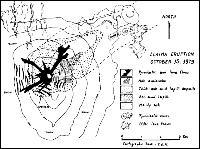 |
Figure 1. Sketch map of Llaima showing the deposits from the 15 October 1979 eruption. Courtesy of Hugo Moreno. |
Information Contacts: H. Moreno R. and O. González-Ferrán, Univ. de Chile, Santiago.
Two new explosions; October lava flows described
H. Moreno and C. Marangunic visited the volcano on 28 October. They found the flow fronts to be composed of fresh lava [debris] and pyroclastic fragments mixed with older material, forming a kind of "lava debris flow" [and pyroclastic flow] that moved rapidly over the ice. The continuous fumarolic activity that followed the eruption was quite intense on the 28th.
Pedro Riffo A. reports that two new explosions from the summit crater took place at 1226 on 24 November. A steam and ash column rose about 2 km. Minor emission of fine dark gray to brownish ash followed the main explosions.
Information Contacts: H. Moreno R., Univ. de Chile, Santiago; P. Riffo A., Univ. de Chile, Temuco.
Dense columns of dark ash emitted from crater
"An eruption from Llaima's central crater was observed between 0800 and 1800 on 20 April, with emission of dense columns of dark ash that fell around the crater. The activity could be seen from Temuco, 70 km W of the volcano. Tourists and residents of the area immediately around the volcano were evacuated by police and forest guards, and vehicle traffic was restricted."
Information Contacts: H. Moreno R., Univ. de Chile, Santiago.
New fumarolic activity
New fumarolic activity has been detected from Llaima's south peak, 1 km SSE of the main crater. A very weak white plume observed in April 1987 strengthened toward the end of the year. Increased activity was evident on 27 March 1988, when vapor was rising from all of the south peak's summit area, and some E flank fractures emitted small fumarolic plumes.
Information Contacts: H. Moreno, Univ de Chile.
Continued fumarolic activity from northern and southern cones
Ground and aerial observations on 20 January showed water vapor and other gases emerging from the main northern summit crater, while fumaroles on the summit of the southern cone emitted only water vapor. Water vapor fumaroles were also present on the southern summit's upper SE flank, where an older crater had collapsed and was breached to the SE during the February 1957 eruption. Fumaroles on the southern summit have been increasing in number and intensity since 1984.
Information Contacts: H. Moreno, Univ de Chile; J. Naranjo, SERNAGEOMIN, Santiago.
Small explosion ejects incandescent column; strong seismicity
A small explosion on 25 February, followed by the ejection of a glowing column from the main crater, was reported by Conguillio National Park administrator Omar Toledo. He added that small sediment-laden streams of water had flowed down the E flank at times when thawing does not normally occur. Field observations by geologists 5-18 March revealed occasional increases in fumarolic activity from the main crater. On 10 March, vigorous 40-60-second puffs of gas were emitted every minute during the early evening. After a summit climb, Conguillio National Park rangers reported that intense fumarolic activity produced grayish gases and a strong sulfur odor. Rockslides occurred every 1-2 hours on the NE flank.
A portable seismograph was operated 19-22 March at the volcano's W foot (in Los Paraguas National Park) by Jaime Campos and Bertrad Delovis, Dept de Geofísica, Univ de Chile. Intense volcanic earthquakes and tremor were recorded. Another portable seismograph will be installed at the NE foot (near Conguillio Lake) by Univ de la Frontera scientists.
Information Contacts: H. Moreno, Univ de Chile; J. Naranjo, SERNAGEOMIN, Santiago.
Microearthquakes and tremor
Seismicity was recorded during fieldwork on 13-16 January, using a MEQ-800 portable seismograph, at 1,600 m elev. . . . During the observations, the daily number of microearthquakes decreased from 700 on 13 January, and averaged 418 (figure 2). Tremor frequency oscillated between 1 and 1.6 Hz, with a maximum episode-duration of 70 seconds and a maximum daily total of 11.5 hours (13 January). Seismicity was record<->ed at the same site on 25-30 January 1991, when 650 microearthquakes were recorded, with a daily average of 120 events and a maximum of 140 events (27 January). Tremor frequency oscillated between 1 and 1.8 Hz, with a maximum duration of 55 seconds.
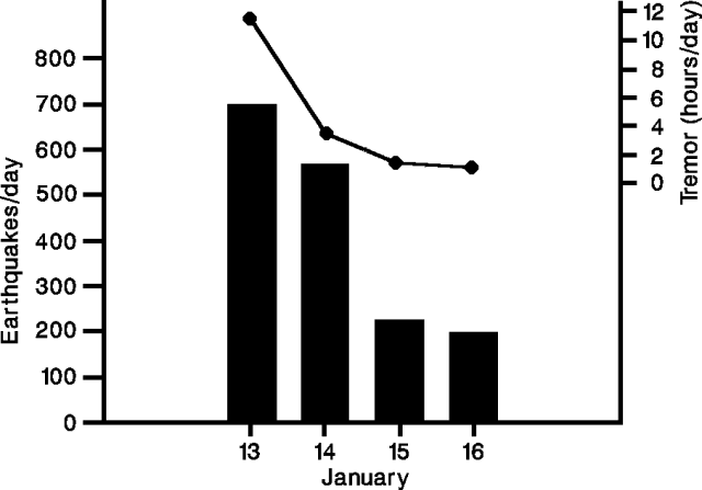 |
Figure 2. Daily hours of tremor (top) and number of earthquakes (bottom) at Llaima, 13-16 January 1992. Courtesy of Gustavo Fuentealba. |
Information Contacts: G. Fuentealba and M. Murillo, Univ de La Frontera; J. Cayupi and M. Petit-Breuilh, Fundación Andes, Temuco.
Three summit-crater explosions; frequent seismicity
Three explosions from the summit crater were observed between 23 August and 2 September. Intense fumarolic and solfataric activity has continued since 23 August, with gas emissions and phreatic explosions in early September that rose 400 m and fed a plume 45 km long. About 2500 seismic events were recorded 4-6 September by two portable MEQ-800 seismographs 5 km from the crater; tremor frequency was 1.2-1.4 Hz. Seismicity was concentrated on the N flank where the 1956-57 eruptions occurred. Seismicity during fieldwork in January 1991 and January 1992 averaged a few hundred events per day (17:2). Winter snow still covers the volcano, creating the potential for lahars.
Information Contacts: G. Fuentealba, M. Petit-Breuilh, and P. Peña,Univ de la Frontera; U.S. Embassy, Santiago, Chile.
Eruption with 4 km ash column, subglacial lava, lahars, and flooding
At about 0600 on 17 May this glacier-capped stratovolcano. . . began a Strombolian-to-subplinian eruption with associated lahars and flooding. The eruption produced a column composed of ash, gases, and steam that reached ~ 4,000-5,000 m above the summit, which itself has an elevation of 3,125 m. Tephra fell over a cigar-shaped zone trending about ESE (figures 3 and 4). In early assessments of the eruption, workers estimated the VEI as about 2 or 3 (moderate to moderately large).
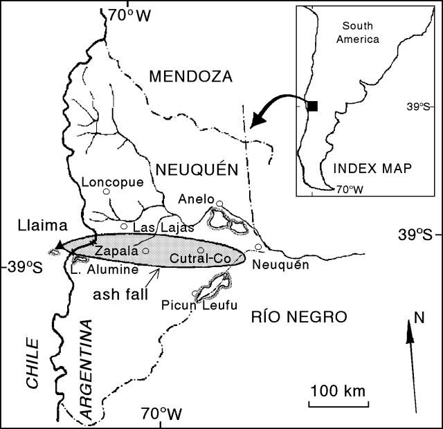 |
Figure 3. Map showing location of the 17 May Llaima ash-fall deposit. The shaded area includes ash of thickness greater than about 1 mm. Dash-dot lines show province boundaries in Argentina: Mendoza, Neuquén, and Río Negro. Base map provided courtesy of Daniel Delpino and Adriana Bermudez (A.C.V.V.R.). |
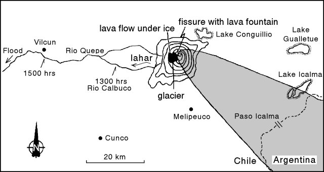 |
Figure 4. Annotated sketch map of the area near Llaima, emphasizing aspects of the 17 May eruption adjacent to the volcano. Contours are only drawn for the volcano, not the surrounding topography. Lowest contour shown is at ~ 1,600 m (200 m contour interval). Labelled times indicate arrival of lahars at various points along the rivers. Courtesy of Hugo Moreno. |
Lava, lahars, and flooding. Llaima has two historically active craters, one at the summit and the other to the SE. This eruption issued from a fissure that grew in the crater at the summit (figure 4). The 500-m-long, SW-trending fissure produced explosions at 3-second intervals and lava fountains. A lava flow developed. The flow drained across the bottom of a glacier located on Llaima's W flank.
Runoff from melting snow and ice caused lahars to descend the W flank into the Calbuco and Quepe rivers. Arrival times for the lahars are shown for two points on figure 4. At further distances from the volcano flooding occurred.
Plume. The ash plume was initially seen for at least 40 km, reaching Lake Icalma, Chile (figure 4) and Lake Aluminé, Argentina (figure 3). Later, at 0930, one witness at Paso Icalma (figure 4) saw a "big, dark, and dense ball of smoke" rising in the sky.
Ash also fell in the towns of Zapala and Cutral-Co, in Neuquén Province, Argentina, settlements with a combined population of ~ 105,000 (figure 3). It fell between the hours of 1330 and 1430 in Zapala, and beginning at 1530 in Cutral-Co. In these towns, falling ash hampered all normal activities and irritated people's eyes and respiratory systems. In the first stage of the ash advance, the sky changed from open sunlight to a dark ash cloud looming over the horizon. About a half hour later the ash cloud completely engulfed the sky.
Ashfall was weak at a meteorological station ~20 km NNE of the town of Neuquén, a location outside and E of the 1 mm isopach shown on figure 3, and a distance of 300 km from Llaima. The time given for this ash fall was 1600, just half an hour after ash began falling at Cutral-Co. Another report, however, mentioned light ashfall at essentially the same spot (the Neuquén airport) beginning at 1900.
Pilots on at least five commercial flights recognized the plume; available reports for 17 May covered these times: (a) between 0900 and 1000, (b) 1330, and (c) between 1600 and 1700. For these intervals, the available pilot reports describe the plume as follows: (a) fumarolic, (b) a volcanic cloud, and (c) tenuous clouds quickly dispersing during what was described as a lull in the eruption. Besides these reports (provided by Raul Rodano), Daniel Delpino and Adriana Bermudez mentioned one other: It stated that the plume rose 10 km above Llaima.
Using the infrared capability of geostationary satellite Meteosat 3, Raul Rodano imaged the plume for the time 1200, 17 May. He also detected the plume between 1800 and 1900, but after this it became indistinguishable from weather clouds.
Description of the non-proximal ash fall. In Neuquén Province, Argentina, the blanket of ashfall over 1 mm thick was distributed over an area of ~ 37,680 km2 (figure 3). In Argentina, the ash within this isopach was mostly 1-2 mm thick but in some areas the accumulations reached 2-5 cm thick. Near-source deposits in Chile may be thicker, but this has yet to be reported.
Table 1 shows grain-size analyses for tephra collected in Zapala and in Paso Icalma (at 1700). In Zapala the tephra was dominantly dark gray to black in color. The ash was examined by A. M. Case and determined to be composed of amber-colored glass shards of presumed mafic composition. Phenocrysts included plagioclase, pyroxene, and iron-titanium oxides.
Table 1. Preliminary grain-size analysis for two localities in Neuquén Province, Argentina. Dashes indicate lack of significant material in stated size range. Exact values for the size ranges require clarification, but diameters in one classification scheme are given in parenthesis. Data provided courtesy of Daniel Delpino and Adriana Bermudez, A.C.V.V.R.
| Grain Sizes | Paso Icalma (45 km) | Zapala (~135 km) |
| Fine lapilli (> 2 mm) | 9% | -- |
| Coarse ash (< 2 mm) | 25% | -- |
| Medium-to-coarse ash | -- | 1% |
| Medium ash | 21% | -- |
| Fine ash (< 0.06 mm) | 32% | 44% |
| Very fine ash | 6% | 45% |
| Dust | 7% | 10% |
Ongoing monitoring, damage estimate, and history. Gustavo Fuentealba set up some portable seismographs that were to be joined by additional instruments from the national civil defense agency (ONEMI). According to an ONEMI report the eruption was preceded by seismic activity.
Both during and after the eruption, volcanologists communicated closely with their respective civil authorities. In Argentina, routine commercial flights were suspended in order to prevent encounters with the ash plume. In Chile, according to Norman Banks, ten staff members of the Conguillio national park and 22 families in the highest risk zones were evacuated, 7 by helicopter. Another 2,000-3,000 inhabitants of the towns of Melipeuco (15 km SSE) and Cherquenco (18 km W) were preparing for possible evacuation.
According to Norman Banks: "The current eruption has been preceded by several years of unrest, [with Llaima] sending a steam column to 1 km in September of 1992, and provoking two other brief episodes of steam or heightened seismic activity, the latest in December of 1993." He also noted that lahars associated with the current eruption caused an estimated $1.25 million (US) damage to Chilean roads and bridges.
Information Contacts: H. Moreno, SERNAGEOMIN, Temuco (also at Univ de Chile); ONEMI, Santiago; G. Fuentealba, Univ de la Frontera, Temuco; N. Banks, American Embassy, Santiago; El Mercurio news articles; R. Rodano, Aerolineas Argentinas, Buenos Aires; D. Delpino and A. Bermudez, A.C.V.V.R., Neuquén, Argentina.
Additional details on the 17-19 May eruptions
. . .The eruption produced Strombolian-fed, partially subglacial lava flows. The resulting meltwater caused lahars and chocolate-colored floods (figure 5). On 17 May Llaima also produced a column composed of ash, gas, and steam that reached ~ 4,000-5,000 m above its summit. Tephra fell over a 300-km-long, cigar-shaped zone trending about ESE (figure 6); it fell mainly on 17 May but limited falls also took place on 18 and 19 May.
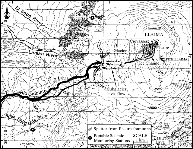 |
Figure 5. Annotated sketch map of the area near Llaima on 21 May 1994. Contour intervals are 50 m (but note that in some snow-and ice-covered areas intermediate contours are missing due to data-transmission problems). The map emphasizes lava and subsequent lahars produced when lava melted glacial ice. The extent and path of the subglacial lava flow are incompletely known. Courtesy of H. Moreno. |
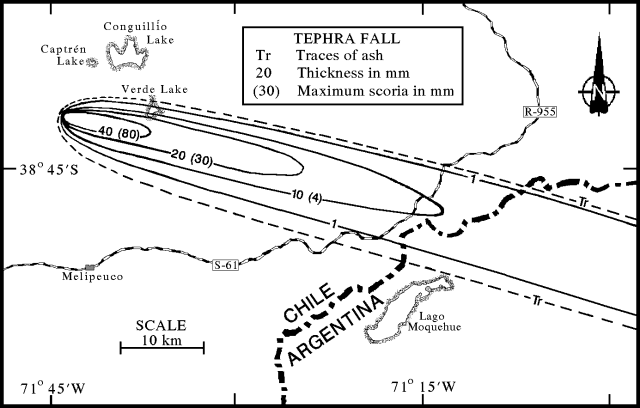 |
Figure 6. Isopach and isopleth map of the Llaima tephra falls of 17-19 May 1994. Values given are in units of millimeters with thicknesses shown first, and grain-size diameters in parentheses. Courtesy of H. Moreno. |
Observations prior to eruption. Hugo Moreno compiled the following list of pre-eruptive observations. In July 1993 after a long rainstorm, Conguillío lake, located on the NE foot of Llaima (figure 6), rose ~ 10 m above its typical seasonal height. It stayed at this elevated height until at least late-December. The magnitude and duration of the lake level rise were unprecedented since 1957, the year of the last big eruption that brought lava to the surface.
In November 1993, rangers of Conguillío national park reported underground rumbling on the N foot of the volcano (Captrén). A video taken from a small aircraft on 25 December showed that the crater area lacked many visible fumaroles. Specifically, the main crater, which was covered by ice, only hosted a very weak fumarole on its SW side. Llaima typically exhibits more vigorous fumaroles; their absence was an anomaly.
A seismic survey (14-17 February, ~10 km E of Llaima at Verde lake: figure 6) found seismic events had an average frequency of about 1.0 Hz, a typical result for Llaima (e.g., 1.2-1.4 Hz in September 1992, 17:8). During 16-17 February a 2-fold increase in the number of events took place, from 90 to 180 events. The events were interpreted as due to magma degassing. A later seismic survey from the same area, 8-10 March, recorded 150-160 events/day with average frequencies in the range 1.0-2.4 Hz. On 22 March a portable seismic station on the W slope of the volcano (Los Paraguas) recorded events reaching still higher average frequency (1.6-3.0 Hz). The consistent increase of the average frequency since February was interpreted as due to slow ascent of magma along the volcano's main conduit.
H. Moreno and S. Barrientos conducted precise leveling, dry tilt, and electronic distance meter (EDM) measurements during 24 February-1 March on the volcano's E flank. Again, except for weak fumes on the SW rim, no fumaroles were seen coming from the main crater. The S summit area ("Pichillaima," figure 5) displayed many small fumaroles; these have progressively increased since 1984.
17-19 May eruptions. The first report of an eruption came from the Melipeuco Police Station, located ~20 km S of the volcano (figure 6), where at 0500-0600 on 17 May observers saw explosions above the main crater. At about 0600 they watched a dense column of ash, gas, and steam issue from the crater; a strong wind dispersed these products toward the ESE.
Between 0900 and 1000 three Chilean domestic (LAN) flights reported the ash column rising 4-5 km above the summit. Ultimately, the plume disrupted several other commercial flights, especially in Argentina.
Between 1100 and 1530 a Chilean Air Force helicopter carried observers to the erupting snow- and ice-capped stratovolcano's W and N sides. On the SSW side of the main crater the aerial observers saw at least four lava fountains escaping from a fissure. The areas covered by spatter from these fountains are shown on figure 5. The fissure was ~500-m long, trending N10°E; it vented small explosions at intervals of ~3 seconds. Lava fountains reached up to ~ 200 m high and joined a lava flow that ran under the adjacent glacier to the W. Llaima's western glacier is significant. Prior to the eruption it had an area of ~ 17.2 km2 and a liquid-phase volume of ~ 367 x 106 m3. Along the fissure the ice underwent rapid, violent melting and vaporization. Many explosions penetrated through the ice.
Aerial observers noted that downslope of the eruption fissure the W glacier discharged steam and explosions. These exhalations indicated that the lava continued some distance beneath the glacial ice, apparently turning toward the W and entering the alpine reaches of either the Lanlan or Calbuco rivers, or both (figure 5). The lava's subglacial path became more apparent later, on 21 May, when the volcano next became visible from the ground. The main crater rim then contained a small notch on its SSW side. The notch held an "ice channel" with a pronounced westerly bend (figure 5). On 21 May, the channel's width varied from about 50 m above the bend to 150 m below it.
On 17 May the invading lava melted sufficient glacial ice so that at about 1200 a lahar was identified moving down the Calbuco river (figure 5). Downstream at a village off the W edge of figure 5 (El Danubio, ~16 km WSW of the summit), the lahar passed at about 1245-0100 carrying trees, sediments, ice blocks, and boulders up to 9 m in diameter. Within a deep gully the lahar reached 35-m wide, 19-m high, and its volume was estimated as 2.5 x 10⁶ m3.
After the lahar reached the Quipe river (~25 km W of Llaima's summit) it advanced as a chocolate-colored flood. At about this point observers in the helicopter flew to the town of Vilcún (43 km W of Llaima's summit), landed on a small bridge, and alerted residents of the advancing floodwaters. The floodwaters arrived at 1515; subsequently the river rose 4.3 m and widened from 32 to 61 m. Estimated water velocity was 13-14 km/hr. During the interval 1630-1700, observers at El Danubio noted the passage of a second flood. In addition to stranding and killing thousands of fish, the lahar and associated flooding nearly covered a cemetery, cut across roads, and destroyed five bridges across the Rio Calbuco; 59 people were rescued from its path.
Observers near the volcano on 17 May saw the ash column blow toward the ESE in the region below about 5 km elevation. During the interval from 0800-1230 ash affected the area immediately adjacent Llaima's E and SE flanks (the Trufultruful river-Verde lake area). During 1000-1330, peaking at 1300-1330, ash fall increased in the area along the ash-distribution axis near the E border of Chile (the Icalma-Cruzaco area). The ash column contained both ash- and water-rich zones.
At 2000 on 18 May, a new, coarser ash fell for several minutes on Cruzaco (~46 km SSE of Llaima). Cruzaco again received ash for the last time on 19 May at 1200; this time it was very fine. Ash samples collected in Cruzaco contained 0.1-4 mm diameter grains of black and reddish-colored scoria with phenocrysts of plagioclase, olivine, and magnetite. Some samples were also taken of water and Coirón grasses that feed livestock, in order to make sulfide, chloride, and other chemical analyses.
Seismic and satellite data. Abnormally high seismicity occurred after the eruption until at least 14 June when monitoring ceased. During this interval, increased seismicity took place on 31 May-1 June, coincident with loud subterranean noises reported from 20 km S at Melipeuco, and summit incandescence seen from 24 km W at Cherquenco.
During the nights of 13-19 June, subterranean rumblings were heard by Pablo Parra of the Hosteria Hue-Telen (Melipeuco) when he was at Verde Lake (figure 6). The rumblings lacked associated smoke-puffs or incandescence. He also reported that although clouds and rain generally shrouded the summit in mid-June, on either 14 or 15 June clear weather revealed a gray-white plume ("normal" for the volcano) changing to a dark-gray plume (distinctly different from "normal"). Parra also noted that Pichillaima exhibited a recent slump on its SE side. He thought the slump was reminiscent of the one seen prior to the explosive 1957 eruption, and he recalled how he and area residents heard similar rumblings for several years prior to that eruption.
Satellite data of Llaima includes GOES-E images collected between 17 and 23 May, excepting 19 May. Steve Matthews, Kath Walley, and Robin Sharphouse have stored the GOES-E images in PDF and TIFF computer format.
The first GOES-E image, at 0230, shortly before the eruption, shows no eruption plume. Plume-like reflectors were observed on the E side of the Chile-Argentina border as follows: (a) on 18 May at 0926, (b) on 20 May at 0926 and 1430, and (c) on 22 May at 1430. On other days cloud cover obscured the area.
The GOES-E image for 18 May contains a small, compact reflector ~100 km E of the volcano. The two 20 May images depict an elongate, plume-like reflector extending from the border directly east of the volcano for ~ 150 km in a SE direction. On the 22 May image a similar feature extends from the border for ~150 km in a NE direction. In all cases these features were more intense than nearby clouds and may represent the ash plume.
Other remarks. The 17 May eruption was ranked by Hugo Moreno as VEI 2 with a strong phreatic component. The exact extent of the subglacial lava flow remains uncertain. The eruption caused no reported casualties.
Information Contacts: H. Moreno1, G. Fuentealba2, M. Murillo2, M. Petit-Breuilh2, J. Cayupi2, and P. Peña2, SERNAGEOMIN, Temuco, Chile; A. Rivera, Univ de Chile, Santiago; D. Lescinsky, Arizona State University; S. Mathews, Univ of Bristol, U.K.; K. Walley and R. Sharphouse, Ulverston Victoria High School, U.K.
New eruptive episode involves multiple explosive events
On 25 August 1994 Llaima volcano began a new eruptive episode. Its last eruption started on 17 May, generating an ash column >4 km high, subglacial lava, lahars, and flooding. The subglacial lava left a melted ice channel down the SW side of the volcano. From a point ~5.4 km W of the summit (Las Paraguas) at 0900 and 0915 on 21 August people felt two earthquakes of intensity II and III. On 25 August, beginning at 0900, observers heard explosions from the principal crater, and at 1135 the first ash column became visible.
Between 1630 and 1800 on 26 August, a gas-and-ash cloud rose 350 m above the summit and a portion of the cloud extended along the ice channel. Continuing from 1930 through the night, the eruption increased in intensity, ejecting gases and incandescent tephra up to 500 m above the summit; some tephra fell as far away as the summit's outer flanks. On 27-28 August the volcano was completely cloud covered, preventing direct visual observations. Some sources reported feeling continuous explosion shocks throughout 27 August, and one source felt 3 clear explosion shocks at 5-second intervals on 28 August. These observations suggested continuing eruptions.
Several seismic stations were installed during the crisis; the first began operation at 1458 on 26 August. During its first 21.2 hours of operation station El Trueno, located 18 km WNW of the principal crater (N of Cherquenco village), revealed harmonic tremor with a predominant frequency of 1.1 Hz. It is fitting to emphasize that in this situation the gain of the seismic system was relatively low (66 on a MEQ-800 instrument), and in May higher gains were in use (78 and 84). In essence, the August tremor had higher amplitude than it did in a roughly 6-hour post-effusive period associated with the May eruption. In addition, other high-frequency signals were detected during parts of 26-27 August, which are still under study. In the last 15 hours of this interval the record contains banded tremor predominantly of 1.0 Hz frequency.
A second seismic station began operation at 1046 on 27 August when a portable MEQ-800 (filter 0-5, gain 72) was installed. Station MELI was placed 14.5 km from the principal crater (N of Melipeuco, a town 20 km SSE of the volcano). The instrument detected harmonic tremor of 1.0-1.2 Hz frequency at roughly 4-5 episodes/minute. The tremor signal was thought to arise from magma-water contact in Llaima's magma-laden conduit system. Tremor of the same frequency continued for the first 6 hours of 28 August (0000-0600), but grew in amplitude and frequency range (to 1.5 Hz). Banded tremor appeared, possibly indicating pressurization processes associated with the ascent of a new batch of magma from depth. In the interval 1100 to 1752 on 28 August the seismicity remained roughly constant, although there was a tendency toward increased energy release.
A third station, installed at 1300 on 27 August, was located 1.1 km from Lago Verde, 7 km E from the principal crater. During 1300-1700 this instrument received such strong tremor signal that it had to be set at minimum gain (60). Later, the station was moved farther away, to Pangueco, 10 km from the principal crater.
On 28 August, scientists monitoring the volcano made several "General Recommendations." These included an Orange alert, 72 hours of vigilant watching of the seismic data, warnings to stay away from Llaima's drainages, and to remain attentive for further official instructions.
A new eruptive phase started at midnight on 28 August when a strong explosion produced a gas-and-ash column. The column was observed in Melipeuco beginning at 0300 when the sky cleared. The activity decreased noticeably by 0510 but reactivated so that between 0640 and 0940 puffs of gas-and-ash in the crater reached 100-600 m above the rim. Thereafter they decayed and grew weak though constant. Between 1120 and 1209 pyroclastic emissions reactivated, discharging a continuous column to 1,000 m above the crater with explosions producing dense scrolls every 5 seconds (VEI = 2).
A 4-hour overflight began at 1125 on 29 August. During that interval the plume mainly rose 400-500 m, but sometimes 1,000 m, above the principal crater's rim. Strong winds came from the W, carrying a visible plume at least 80 km toward the Andean passes "Pino Hachado" and "El Arco" along the Argentine border. The plume lay between 3,200 and 4,000 m altitude; vapor appeared to be absent in both the plume and the column suggesting a very magmatic eruption. The source vent was a 100-m-diameter crater in the E side of the principal crater, surrounded by a small spatter-cone covering the crater floor. From mid-day until 1700 erupted material rose 600-1,000 m and the wind continued to carry the plume E. At 1740 the eruptive intensity decreased but at 1818 it increased, again sending ash 600-700 m above the crater. After 1930 frequent intermittent explosions tossed more ejecta onto the spatter cone verifying its mode of the construction.
Seismicity monitored at station MEI captured the 29 August midnight explosion noted above. In the interval from 2200 on 28 August to 0100 on 29 August, the seismic record showed increased tremor amplitude (3-5 mm at a gain setting of 66) at frequencies of 1.1-1.2 Hz. Later, from 0200-0430, tremor frequency remained stationary at 1.1 Hz, amplitude dropped, and intervals of banded tremor prevailed. Further decreases in amplitude occurred later (0841-1909, 29 August), and while the frequency range of the tremor remained approximately stationary, tremor dropped to a level from where it only appeared episodically.
On 28 or 29 August the Emergency Committee met with members of the community to explain Llaima's activity, including a summary of the eruption character and fundamentals to help maintain civil calm and at the same time to convey potential hazards. Civil calm was called for owing to preparedness by the regional government, community groups, Carabineros, firefighters, the Chilean Air Force, and other groups. Hazard status remained at alert-level Orange.
On 30 August the ash eruption intensified; column height oscillated 2-3.7 km above the crater (corresponding to VEI 2). At 1603 the first dense, vapor-rich ejection took place; 38 minutes later an intermediate phase began, with vapor discharge accompanied by increased amounts of ash. The highest ash column during this phase ascended to 1.5 km above the crater. Vapor-rich and ash-rich phases alternated for ~ 3 hours (until 1901). At 2100 venting stopped. On 31 August, vapor discharge became pronounced around 0900 and continued until 1600.
Beginning at 2000 on 30 August and again at 0155 on 31 August, there was continuous tremor in the 0.9-1.0 Hz frequency range followed by ~ 40 minutes of banded tremor of similar frequency. Seismic quiet prevailed during the next 6 hours at stations MELI and PANG. Seismicity also remained low from 31 August until at least 0941 on 2 September.
Figure 7 shows a sketch of the crater seen during a 1 September overflight of Llaima (in a Chilean Air Force aircraft); the flight took place during calm, clear weather and visibility into the principal crater was excellent. The crater's normally snow-and-ice-covered surface was completely blackened by ashfall; about 15 fumaroles remained, yet ash-emissions were absent. A small cone covered most of the crater floor, its 100-m-diameter, funnel-shaped source vent lay adjacent to the SE crater wall (figure 8). On 1 September, the fissure of melting ice created by the 17 May subglacial lava flow still continued to send up a significant vapor plume. Although mostly westerly winds were noted by observers, the weak ash distribution was over a wide arc, ranging from compass bearings 190-310 (figure 9). There were two lobes of heavier deposition, one toward the N, the other ESE.
Because of decreases in both volcanic and seismic activity, around 2 August scientists lowered the hazard status from Orange to Yellow. However, they expressed concern about potential restriction or blockage of the vent by new deposits in the main crater. They were also concerned about the recent shift in seismic character compared to the previous 4 years.
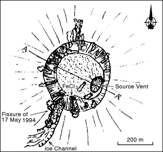 |
Figure 7. Sketch looking down on Llaima's principal crater at 1500 on 1 September. Courtesy of Hugo Moreno. |
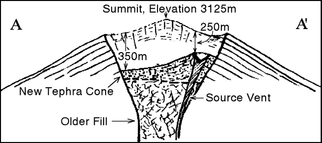 |
Figure 8. Preliminary cross section of Llaima's crater showing estimates of the fill thickness and the funnel-shaped vent from the recent eruption. Courtesy of Hugo Moreno. |
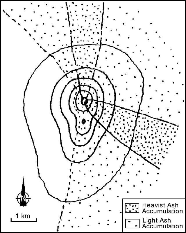 |
Figure 9. Zones of major ash cover from the Llaima eruptions in late-August. The ESE lobe reached about 6 km from the source, the length of the N lobe was unreported. Courtesy of Hugo Moreno. |
Information Contacts: H. Moreno1, M. Murillo, M. Petit-Breuilh, and P. Peña, SERNAGEOMIN, Temuco. 1Also at Univ de Chile, Santiago.
Minor fumarolic activity; small scoria cone collapsed in the crater
One of the most active volcanoes in Chile, Llaima's last reported eruptive episode began on 17 May 1994. An overflight made in the late morning of 15 February (in conjunction with Simon Young and John Simmons) disclosed only minor fumarolic activity. The fumarolic activity focused on the N internal wall of the main crater. In accord with the minor fumarolic activity, no new ash was seen. The summer ice melt has exposed the May and August 1994 scoria deposits (BGVN 19:04, 19:05, and 19:08), layers blackening the glaciers and rocks on the volcano's slopes. Along the crater's SSW border, a roughly 200-m-deep notch exposed alternating lava and tephra layers that mantle the edifice. A small scoria cone surrounding the source vent sat in the SE portion of the crater after the 26-30 August 1994 eruption. That feature later collapsed without leaving a visible trace. The crater itself had a depth of ~350 m.
The episode that began on 17 May 1994 generated a Strombolian-to-subplinian eruption with associated lahars and flooding, and produced a column ~4-5 km above the summit. Tephra fell over a cigar-shaped zone trending about ESE. A 500-m-long, SW-trending fissure produced explosions and lava fountains. Lava flowed across the bottom of a glacier on Llaima's W flank, melting snow and ice that caused lahars to descend into the Calbuco and Quepe rivers. Flooding occurred farther from the volcano.
Information Contacts: Jose Antonio Naranjo, Servicio Nacional de Geologia y Mineria, Avenida Santa Maria 0104, Casilla 1347, Santiago, Chile.
Minor eruption just after a M 4.0 earthquake 160 km to the east
Beginning on 13 October 1995 Llaima started emitting gases and occasional ash; in addition, during the night the northern principal crater glowed a rose color. Dominant winds dispersed the eruptive columns toward the SE on 13 October. Three days later, Llaima started emitting a continuous, strong blast of steam that occasionally also contained dark-gray scrolls bearing fine-grained ash. The resulting plume blew NE.
On the night of 20-21 October, the principal crater discharged a strong explosion. Wind carried ash toward the SW, depositing it on the alpine ice. Some ash fell over the Trufultruful valley and the valley's most eastern flanking hills, forming a band or stripe up to 12 km in length.
On 21 October between 1600 and 1800 the volcano gave off a continuous, intense column of vapor and ash. That night, between 2300 and 0100 in the town of Conguillio, residents heard an explosion accompanied by subterranean noises. The following night, observers saw a "ring of fire" over the principal crater, an effect thought to indicate the presence of lava within the crater.
The Servicio Sismologico de la Universidad de Chile reported that seismic activity one day before the eruption, on 12 October, included a M 4.0 earthquake that struck the region; its depth was 70 km; its epicenter fell at the extreme S end of Lake Lieulleu in the Cordillera de Nahuelbuta (38.28°S, 73.408°W), a spot about 160 km E of Llaima. During 20 and 22 October, portable seismometers picked up 1.0-1.5 Hz tremor; on 20 October the tremor appeared about 15-20 seconds before the above-mentioned explosion. It should be noted that such sub-continuous episodes of 1.0-1.5 Hz tremor are relatively rare at Llaima.
The 13-22 October eruptions followed fumarolic activity (BGVN 20:02) and, before that, an outbreak of ash-bearing eruptions in late August 1994 (BGVN 19:08). On the basis of the above behavior, the 24 October SERNAGEOMIN report stated that the volcano had been assigned an alert status of yellow. Llaima, an ice- and snow-covered stratovolcano, is one of the largest and most active in Chile; it erupted in 1990, 1992, and 1994.
Information Contacts: Hugo Moreno1, Gustavo Fuentealba, and Paola Pena, Observatorio Volcanologico de los Andes del Sur, SERNAGEOMIN, Temuco, Chile.
Fumarolic activity at summit vent
A late-March overflight made after a prolonged dry season enabled scientists to see Llaima with relatively low snow levels. The main vent, in the SE part of the summit crater, emitted a bluish gas in poorly defined pulses at intervals of ~45 seconds. Similar pulses observed in mid-March took place at intervals of ~100 seconds.
The upper part of the main crater wall in the NW sector and small areas within the Pichillaima scar E of the main crater gave off diffuse steam emissions. A grayish plume at summit height was traceable for a few tens of kilometers to the ESE.
Information Contacts: Jose Antonio Naranjo, Servicio Nacional de Geología e Minería (SERNAGEOMIN), Av. Santa María 0104, Casilla 10465, Santiago, Chile; Hugo Moreno Roa, Observatorío Volcanogía de los Andes del Sur (OVDAS), Manantial 1710-Carmino del Alba, Temuco, Chile; Simon R. Young, British Geological Survey (BGS), Murchison House, West Mains Road, Edinburgh EH9 3LA, United Kingdom.
Small phreatic explosions but otherwise stable during March-September 1997
Seismic and available visual observations indicated typical activity during March-September 1997. Seismic activity registered during August and September 1997 remained at about the same level as during March-July; the detected events were inferred to be associated with degassing and fluid movement in internal conduits. In some cases the seismic events corresponded with observed small phreatic explosions; however, during August and September clouds engulfed the volcano.
Information Contacts: Gustavo Fuentealba C., Paola Peña S., and Klaus Bataille, Observatorio Volcanológico de Los Andes del Sur (OVDAS), Manantial 1710-Carmino del Alba, Temuco, Chile.
Small explosions, seismicity, and ash output increased during early April 1998
An 8 April 1998 report stated that during the past week Llaima increased its output of small explosions and ash emissions. The amplitude of seismic signals also increased, although the frequency of signals remained fixed at 1.5 Hz. Seismic amplitude (RSAM) values during March averaged about 25% above those of February. Daily RSAM estimates in March jumped to nearly 30 RSAM units on a few days but more frequently only reached about 10 RSAM units. A sample of the seismic record is shown on figure 9.
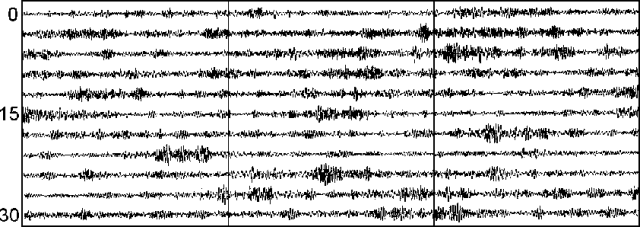 |
Figure 10. Sample seismic record at Llaima (Meli station) on 22 April 1998 beginning at 0400. The tic marks are at 1-minute intervals. Courtesy of OVDAS. |
Information Contacts: Gustavo Fuentealba1 and Paola Peña S., Observatorio Volcanológico de Los Andes del Sur (OVDAS), Manantial 1710-Carmino del Alba, Temuco, Chile; 1Universidad de La Frontera (UFRO), Departamento Ciencias Fisicas, Universidad de la Frontera, Avda. Francisco Salazar 01145, Casilla 54-D, Temuco, Chile.
Park ranger reports puffing steam plumes and fine-ash ejecta
On [about 3-4] April 1998, Miguel Torres, a park ranger in Llaima's N sector (Conguillío) saw steam and fine ash ejected. Falling ash later mantled solar panels. [Additional activity was observed during 22-23 April by J.A. Naranjo.]
A series of events were noted on 22 April, a clear sunny day but some cloudiness on the mountain's slopes. At 1015 from an undisclosed distance to the NNW, [Naranjo] observed puffs of white color emitted at 2-minutes intervals from the N crater. This became a dense grayish white plume that ascended and headed ENE. During this emission, visible fumaroles elsewhere continued unchanged.
At 1040 [Naranjo] noted a decrease in activity, or possibly a shift in atmospheric conditions, that decreased the amount of visible condensation. He still saw puffs of condensing gases, but at much lower intensities than earlier. At 1045, from the Colorado river area he noted a further decrease in activity, with gas puffs escaping at intervals of over 2.5 minutes. At 1054 the plume dissipated and blew SE.
The next day, there were fewer clouds on the slopes. At 0925, [Naranjo] saw Llaima issue a blue-gray plume that advanced ENE. The amount of visible condensation was less than the previous day, however, presumably because of lower relative humidity in the ambient air surrounding the crater and summit. At 1245 [Naranjo] was watching from the E (the sector containing Lake Arcoiris) when a clear increase in steam discharge from the principal crater became apparent; puffs of steam ascended at intervals of 30-35 seconds. The puffs emerged from different parts of the main crater, perhaps due to air turbulence. At this time, minor fumarolic activity also prevailed in the S crater (Pichillaima); this crater regularly gives off sparse plumes even though it has not erupted since 1957. At 1321 [Naranjo] watched clouds form and spread out above the volcano.
Despite these visual observations, Gustavo Fuentealba reported in late July 1998 that Llaima's recent seismic activity had appeared normal.
Information Contacts: Jose Antonio Naranjo, Programa Riesgo Volcánico, Servicio Nacional de Geología e Minería (SERNAGEOMIN), Av. Santa María 0104, Casilla 10465, Santiago, Chile; Gustavo Fuentealba C., Observatorio Volcanológico de Los Andes del Sur (OVDAS), Manantial 1710-Carmino del Alba, Temuco, Chile.
Hybrid seismicity and gas-and-ash emissions prompt increase in alert status
An intense white fumarolic plume was seen at Llaima during the second week of November 1998, along with intermittent gas emissions and occasional ash. Personnel at Conguillio National Park also reported that on a crater visit they noted landslide material on one flank. Fumarolic gas-and-ash columns rose ~1,000 m above the summit and typical emissions of steam were also seen.
During 27-29 January 1999 personnel from the Observatorio Volcanológico de los Andes del Sur (OVDAS) installed a portable digital seismic station in the Green Lake area. The portable station is composed of an L4-C seismograph and a small computer powered by a 12-volt battery. An average of 25 long-period events per hour having frequencies of 1.0-1.2 Hz and durations of 30-40 seconds were registered during the sampling period. Many events associated with intense degassing in the central crater at the time were also registered with frequencies between 0.8 and 1 Hz. Energy reached maximum values of 95 RSAM units. Three isolated high-frequency, long-period events were registered. These events had unusual characteristics and could have been hybrids.
The presence of some hybrid seismic events suggests that the alert status be raised to "Green," the first level of the traffic-light system used by OVDAS.
Information Contacts: Gustavo Fuentealba and Paola Peña, Observatorio Volcanológico de Los Andes del Sur (OVDAS), Servicio Nacional de Geología e Minería (SERNAGEOMIN), Manantial 1710-Carmino del Alba, Temuco, Chile (URL: http://www.sernageomin.cl/).
Extreme glacial crevassing and melting; April 2003 ash emissions
During late 2002 and early 2003 Chilean scientists at Llaima documented increases in seismicity, fumarolic output, a minor eruption, and pronounced glacial disruption. For example, on 8 January 2003 they found that the ice and snow formerly capping the N and S craters had completely melted. Larger eruptions began in April 2003, depositing pyroclastic material, dispersing numerous ballistic blocks, and creating substantial plumes.
Although this report covers the time interval from January 2002 through most of April 2003, the concern then was that Llaima might erupt with the vigor seen in 1994 (BGVN 19:04 and 19:05). However, during the 2002-03 reporting interval eruptions remained comparatively modest.
Ice covered, passively degassing. On 26 September and 30 October 2002, scientists from Chile's Volcanic Risk Program and the Volcanologic Observatory of the South Andes (OVDAS) flew over Llaima in response to steady increases in seismicity and fumarolic activity since the end of June 2002. On the 26 September flight they viewed the summit with its N (main) crater, and Pichillaima, the smaller SE-flank cone and its crater. They found only a weak steam plume rising gently from the main crater and attaining little additional height. This was in contrast to typical previous behavior, which consisted of puffs that rose several hundred meters before dissipating.
The 26 September 2002 aerial observations found the internal walls of the main crater draped in ice and snow. Pichillaima lay beneath a cover of clean ice and snow, and its crater emitted only a small gas plume. The overall scene was of quiet, with minor degassing amid frigid conditions.
Views of the main crater rim on 30 October 2002 indicated minor ash on the snow, an irregular, figure-eight-shaped hole emitting gases, and a much larger and optically denser steam plume than on 26 September. Llaima's cover of ice and snow was more complete than noted in October 1998. Thus, by comparison, in late 2002 visible signs of thermal activity had diminished significantly. In contrast to what was typically seen, the crater's ice-covered internal walls lacked escaping gases. Except for seismicity, the ice-bound Llaima seemed stable.
Seismically restless. Despite the lack of visible volcanism or thermal activity, the seismicity in September 2002 was notably greater than in January 2002 (table 2). The frequency of tremor increased from 0.9 Hz in January 2002 (a typical value in times of relative quiet) to 1.2 Hz in September 2002. In describing April 2003 tremor amplitude the OVDAS reports stated that it was about "5-fold larger" than at base level.
Table 2. Seismic activity at Llaima summarized as RSAM (Real-time seismic amplitude) values and principal tremor frequencies. In times of relative quiet, baseline values at Llaima are ~ 20 RSAM units and 0.9 Hz. These data were taken from reports by OVDAS-SERNAGEOMIN (which omitted some time intervals).
| Date | Seismicity (RSAM units) | Tremor frequency (Hz) |
| Jan 2002 | 28 | 0.9 |
| Jun 2002 | 20 | -- |
| Sep 2002 | 57 | 1.2 |
| Dec 2002 | 99 | 1.2 (during 18-20 Dec) |
| Mid-Jan 2003 | 93 | -- |
| Late Jan 2003 | 60 | -- |
| Apr 2003 | 92 | 1-2.2 |
| 18-19 Apr 2003 | 98 | -- |
In September 2002, seismic instruments included two permanent stations (LLAI and MELI) located respectively on Llaima's S flank and S foot. In December 2002, there were two portable seismic receivers placed on the E flank at Lago Verde, which also recorded unrest. The seismicity continued to increase from December 2002 to mid-January 2003 (from ~70 to ~100 RSAM units). After that, it diminished and stabilized for about two months.
Sudden changes. A flight on 8 January 2003 led OVDAS to see remarkable changes since the late 2003 observations (figure 11). First, the dense fumarole emitted from the main crater was much stronger than the one seen 26 September 2002 (figure 11, top left). Second, the ice and snow had completely melted from main crater's internal walls. Third, complete melting of ice and snow had left exposed rock at both the summit and Pichillaima (figure 11, lower right). Fourth, numerous new crevasses had appeared in the cone's glaciers, particularly on the E flank. Down all flanks of the volcano, the 8 January observers saw ice falls, snow avalanches, ice detachments, and rockfalls.
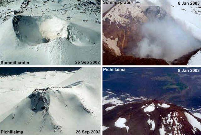 |
Figure 11. Contrasting views of Llaima's summit crater and Pichillaima as seen on 26 September 2002 (left, top and bottom, respectively) compared to 8 January 2003 (right, top and bottom, respectively). The scenes highlight differing conditions, particularly the melting of ice and snow. On 26 September 2002 snow covered most of the edifice. On 8 January 2003 there was an absence of significant ice and snow from parts of the crater walls, rim, and S flanks, and there were increased emissions of volcanic gases. Courtesy of OVDAS-SERNAGEOMIN. |
Although the melting came at the time of the annual thaw, the situation on the volcano indicated that processes such as local heating accelerated the melting. Snow had fallen in early October 2002. The absence of ice and snow cover on both the shaded and unshaded sides of Llaima was cited as evidence indicating elevated rock temperature. Observers saw the melting and also noted a halt to any new accumulation of ice and snow deposits. The melting was attributed to magma at depth in the conduit, and considerable heat emerging at the locations where the ice melted.
The report issued 20 January 2003 noted that field work on Llaima's W side (Cherquenco-El Salto) had disclosed deep new crevasses in the glacial ice reaching 1.5 km long. These were affiliated with avalanching from near the main cone's summit to the cone's NW foot (~ 3 km long by 0.5 km wide). Observers also noticed continued signs of thawing, including the appearance of small fumaroles, which they again attributed to the volcano warming.
The next available reports, from the period 9-11 April, came from eye-witnesses. Rodrigo Marín of Conguillío national park, noted "an increase of fumarole activity in the main crater between 9 and 10 April, which was accompanied by ash emission." In addition, from the N slope (Captrén) people heard underground noises.
At 1330 on 10 April a teacher at Los Andes de Melipeuco elementary school noted three ash explosions that reached ~ 500 m above the main crater and dispersed NE. Several others observers noted ash-bearing emissions from the main crater, including one at 1340 and another at 1350. A park ranger noted that around 2100-2200 on 10 April strong and continuous explosions awoke him and ash began to fall on him in the N-slope sector of Captrén. Later, the explosions became more sporadic, and he heard sounds similar to those made by the motion of heavy machinery. This continued into the early morning of 11 April.
The director of the above-mentioned school reported to OVDAS that on 11 April at 0915 he saw "...continuing ash emission from the main crater." Finally, at 1100 on 11 April, OVDAS observatory (Cerro ñielol-Temuco) staff observed a vertical column, mainly of volcanic gases, which rose to about 600-700 m above the crater rim. This fed a large, horizontal, lenticular cloud ~ 30 km in diameter, the top of which rose to about 3,900 m altitude.
An 11 April helicopter flight disclosed a thin layer of pyroclastic material spread widely across the glaciers on the NE, E, SE, and SW flanks, visible out to distances of ~ 4 km. Impact craters in the ice testified to numerous bouncing and rolling projectiles. Scientists on that flight noted vigorous fumarolic activity and dense clouds with colors and odors indicating the presence of SO2 and HCl. At multiple spots, small fumaroles had sprouted from the crater walls. The crater floor contained a 50-m-diameter vent emitting gases, but no lava flows had emerged. Although the 9-11-April eruptions were modest, they prompted Llaima's hazard status to rise from Green to Yellow.
Figure 12 portrays further melting and exposure of underlying rock at both the summit (top) and Pichillaima (bottom) on 11 April. When photographed, the ice and snow at Pichillaima had receded by 1.0-1.5 km from its topographic high. Ice margins appeared sub-vertical and engulfed circular melt areas.
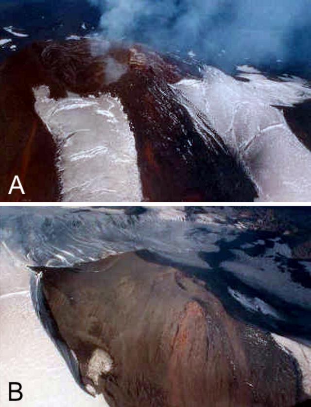 |
Figure 12. Two vistas of Llaima on 11 April 2003 documenting the rapid ice recession and melting around the main crater and Pichillaima. (A) Rim and flanks of the summit and associated main crater standing with large areas ice free. (B) Pichillaima, nearly ice free and encircled by thick ice at the limit of ice melting. Courtesy of OVDAS-SERNAGEOMIN. |
Other amazing photos taken 11 April 2003 revealed dramatic changes in glaciers and snow fields (figure 13). Many regions of the ice appeared to be in motion and undergoing acute mechanical failure. Numerous profound crevasses had emerged, including sets of broadly transverse, arcuate crevasses trending from glacial margins and extending well into their axial areas.
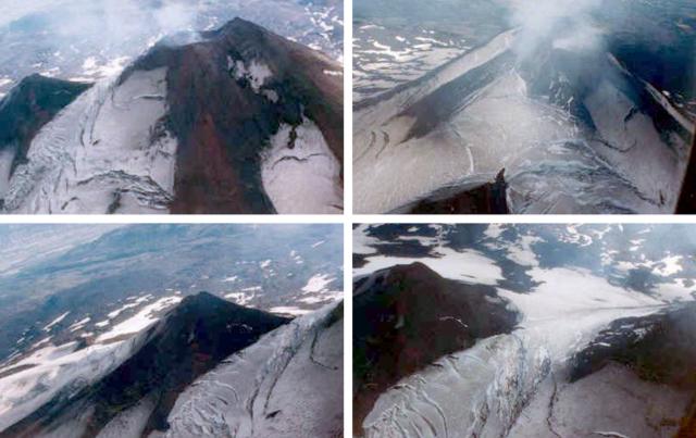 |
Figure 13. Four views of Llaima from helicopter, taken on 11 April 2003 showing newly exposed rock surfaces, newly created ice-margins, and unstable, rapidly breaking glaciers. Llaima's comparatively temperate late-2002 to early-2003 eruptive phase correlated with these remarkable changes in its alpine glaciers. Courtesy of OVDAS-SERNAGEOMIN. |
On 12-13 April 2003 the main crater issued intense pulsing fumarolic degassing at 1- to 3-minute intervals. Odors and celeste color were again indicative of SO2 and HCl components; such emissions were noted until 1500 on 13 April. Other processes on those days included mass wasting, sometimes with associated dust, apparent vibrations at the summit, and ballistic discharges from the main crater. At 1310 on 13 April, expulsions intensified and occurred at 1 minute intervals. Plumes blew E.
Continued observations resulted in the recommendation to maintain the Yellow status at least through 16 April as eruptions began to contain significant tephra. Volcanologists expressed concern that the volcano's glacial ice-cover could undergo further melting, which might lead to large and sudden outbursts of water (glacier bursts) traveling down local drainages.
On 16 April at 1453 OVDAS personnel in the Lago Verde area confirmed gaseous emissions were continuing to escape from the crater. They reported that at 1535 these emissions intensified and reached 200 m above the crater rim, with the plume blowing SE and being visible for ~ 8 km. They noted that at 1537 gaseous emissions escaped at Pichillaima. On the N (Captrén) side of the mountain at 1704 the observers saw gray-colored fumaroles. During 1130-1355 on 17 April from a point near the Lago Verde they perceived SO2 and HCl; they witnessed gas emissions to the NE reaching 200 m above the crater rim and spawning a plume visible for ~ 10 km.
The 20 and 23 April 2003 OVDAS reports discussed poor visibility but the permanent stations indicated high-amplitude tremor and considerable seismicity (eg., 98 RSAM units on 18 and 19 April). OVDAS staff interpreted these signals as due to fluids and gases moving in internal conduits. They also pointed out the absence of high- and low-frequency earthquake swarms, signals that generally precede emissions of ash. Small swarms of long-period earthquakes began, however, on 25 April.
Ascent during mid-April 2003. In mid-April 2003 Klaus Bataille (a physicist and seismologist teaching geophysics at the University of Concepción) and his students conducted field work on Llaima. Amid an interval of seismic and volcanic quiet on 18 April they ascended into the region of ice melt near the summit region, and made direct observations relevant to the issue of heat transport. Bataille made the following comments.
"A week after the explosion announced by the OVDAS, we (8 students and myself) went to install two broadband seismic stations to study the evolution of its activity, and we installed a GPS receiver as well. When we finished with the installation, it was a clear day and we decided to climb as much as we could. We began early in the morning [of 18 April] . . . [and] could see from the distance fumaroles coming from the crater, and several vents with vapor and gases coming out from different places, some 200-300 m below the crater, towards the N. We did not find any impediment to continue climbing, neither physical difficulties nor anomalous activity from the crater. Thus the whole group continued up to 300 m below the crater, where four persons stayed due to physical conditions, and five continued up to the crater. The persons who stayed (me included) realized that there was an incredible warm feeling while laying on the ground. This was due to the amount of vapor with some faint smell of sulphur. We could even take off our jackets and shirts, as long as we were laying flat. After lying for a while it was even too hot to [continue]. Fantastic feeling, lying almost on top of the volcano, with a tremendous view, feeling the warmth through the rocks."
Thus, on 18 April, Bataille and students affirmed the previously stated idea of heat emerging to cause the melting and leading to the sudden emergence of crevasses observed since December 2002. A later clarification from Bataille on the mode of heat transfer (viz., "conductive heating," passed through the rocks; or "convective heating," transported by warmed fluids such as gases) resulted in this statement: "I'm not convinced of 'conductive heating' as a direct source for the ice melting, because of the large amount of gases through the system. I'm inclined instead, to believe that melting of the ice is simply due to the large amount of vapor flowing through the loose rocks. However, I agree that [these] gases have to be produced while in contact with hot material, and in this sense [could] be affected by 'conductive heating.'"
Thus, Bataille observed that the rocks in the ice-melt zone around the summit were warm to the touch. He concluded that they were heated by deeper sources and water vapor transported the heat to the surface.
The scientists discussed their results in a subsequent conference paper (Bataille and others, 2003) and on their website, highlighting the seismic and GPS stations installed on Llaima's W and N sides. The former seismic station, near the Refuge Tucapel, began operating on 17-18 April. The latter seismic station, near Captrén, began operating on 19-20 April.
Their recordings lacked earthquakes that could be linked to deeper sources (no fractures nor seismo-tectonic events) during the period between April and the following 4 months. The whole period was dominated by a sequence of tremors due to the activity associated with the crater. Tremor energy decayed gradually in time. The frequencies involved were generally stable, though peculiar and without a good model for their genesis.
Reference. Bataille, K., Hermosilla, G., and Mora, D., 2003, (title translated from Spanish) Seismic activity of Llaima volcano: Dominated by phreatomagmatic sources?, 10th Chilean Geological Congress (10° Congreso Geológico), session 5, paper 63, (October 2003, Universidad de Concepción) (also cited in Revista geológica de Chile; ISSN 0716-0208)
Information Contacts: Hugo Alberto Moreno Roa, Gustavo Alejandro Fuentealba Cifuentes, Paola Andrea Peña Salazar, Erwin Edinson Medel Segura, Pedro Jorge Ortiz Hernandez, Beatriz Eliana Alarcón Avedaño, Chile Observatorio Volcanológico de los Andes del Sur-Servivio Nacional de Geologia y Mineria (Chile Volcanologic Observatory of the South Andes—National Service of Geology and Mining) (OVDAS-SERNAGEOMIN), Manantial 1710-Carmino del Alba, Temuco, Chile (URL: http://www.sernageomin.cl/); Servicio Nacional de Geología e Minería (SERNAGEOMIN), Av. Santa María 0104, Casilla 10465, Santiago, Chile (URL: http://www.sernageomin.cl/); Klaus Bataille, Departamento Ciencias de la Tierra, Universidad de Concepción, Víctor Lamas 1290, Casilla 160-C, Concepción, Chile (URL: http://www3.udec.cl/geologia/).
Ash plumes observed in May and August 2007; new eruption beginning 1 January 2008
From January 2002 through April 2003 (BGVN 29:02) there were increases in seismicity and fumarolic activity, along with minor eruptions, pronounced glacial melting, and substantial ash and gas plumes. Renewed activity consisting of minor eruptions was reported in May and possibly August 2007, but a larger eruption began on 1 January 2008. The source for most of the following is the Observatorio Volcanológico de los Andes del Sur (OVDAS)-SERNAGEOMIN (Volcano Observatory of the Southern Andes-Chile National Service of Geology and Mining).
On 26 May 2007, the Buenos Aires Volcanic Ash Advisory Center (VAAC) reported that ash plumes from Llaima rose to altitudes of 3-4.3 km and were visible on satellite imagery drifting E. A pilot reported another ash plume on 28 May that rose to an altitude of 5.5-6.7 km and drifted E. On 29 May, an ash plume rose to an altitude of 3 km and drifted E. No further activity was reported until 8 August, when pilots observed a plume to an altitude of 5.2 km drifting E. Ash was not identified on satellite imagery for this date.
Eruption during January 2008. Based on pilot reports and observations of satellite imagery, the Buenos Aires VAAC reported that on 1 January 2008 an ash plume rose to an altitude of 12.5 km and drifted E and ESE. The eruption began at 1820 hours, according to the Chile National Emergency Office. Lava was reported to be visible on the E flank and fumaroles at the summit were noted. The strong explosive activity prompted authorities to raise the Alert level to Yellow. According to news media reports, around 700 people were evacuated from local communities following the initial eruption, including about 200 tourists and National Forest Service employees from the Conguillo National Park. Most of the residents returned the following day when activity declined.
SERNAGEOMIN reported that tremor coincided with the onset of the gas and pyroclastic emissions on 1 January. Lava and incandescent material initially emitted were confined to the crater, but within a few hours, a Strombolian phase began. Soon, brightly glowing material covered much of the previously ice-covered summit (figure 14). Around the time of the eruption, an increase in volume of the Captrén river on the N flank was observed; this was likely a response to the glacial melting.
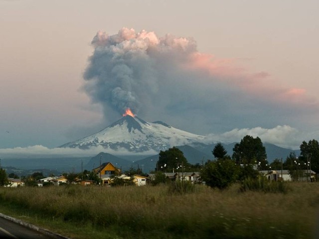 |
Figure 14. Llaima as seen in eruption on 1 January 2008. Photo taken from W of the volcano between Temuco and Vilcun, Chile. Photo by Antonio Vergara via the flikr website (Creative Commons license). |
On the following day, observers on an overflight saw small emissions of ash and gas (mainly steam) and three small lahars on the N and W flanks. Tremor decreased, though explosions continued. Based on pilot reports and satellite imagery, the Buenos Aires VAAC reported that an ash plume rose to an altitude of 12.5 km and drifted E (figure 15). A later overflight revealed that the explosion on 2 January occurred at an area high on the E flank, outside the summit crater. A lava flow on the E flank was also noted. On 3 January an ash plume was visible on satellite imagery at an altitude of 3.7 km drifting NE. Airborne observers noted small sporadic gas-and-ash emissions.
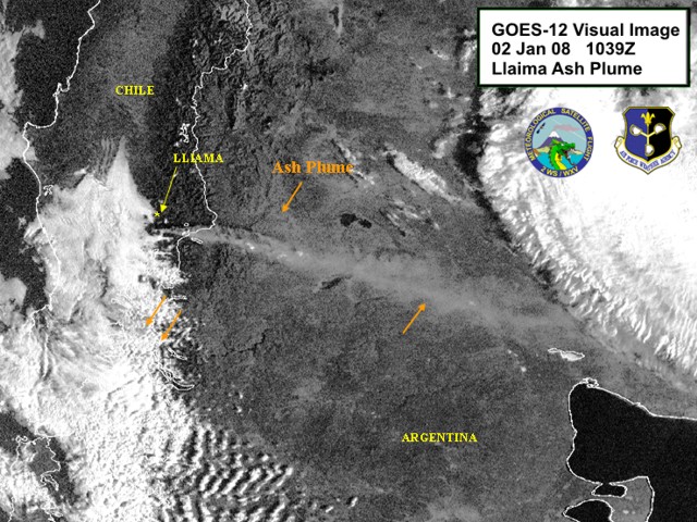 |
Figure 15. A GOES-12 visual image of Llaima plume, captured at 1039 UTC on 2 January 2008. North is toward the top of the image, and the plume blew to the ESE. Courtesy of Charles Holliday, U.S. Air Force Weather Agency. |
In addition to ash, Llaima's eruption released considerable sulfur dioxide (SO2), identified by satellite instruments in the days following the 1 January eruption (figure 16). The initially intense SO2 plume dispersed as it moved E. On 4 January, the plume passed over Tristan da Cunha, a remote archipelago in the South Atlantic Ocean (figure 16). According to Charles Holliday, Simon Carn, and Michon Scott, the SO2 dissipated after 6 January 2008.
 |
Figure 16. An image acquired by the Ozone Monitoring Instrument (OMI) on NASA's Aura satellite showing the progress of the SO2 plume from Llaima during 2-4 January 2008. The island of Tristan de Cunha is shown along in the southern Atlantic Ocean. (In the colored version of this image, red indicates the greatest concentration-pathlength of SO2 and lavender-pink indicates the lowest concentration-pathlength.) OMI measures the total atmospheric column amount of SO2 in Dobson Units (a common unit used in atmospheric research). NASA image courtesy Simon Carn; text modified from that by Simon Carn and Michon Scott. |
Between 1835 and 1915 on 6 January 2008 a helicopter overflight was conducted, coordinated by Jaime Pinto, Director of the Araucania Region Emergency Office (OREMI). Observers noted that main crater vent was clogged with lava (figure 17), which, after the eruption, dropped a few dozen meters inside the crater. During the eruption, lava diverged into two areas in the main crater, draining flows to the W and NE and melting the ice. The melted ice produced three lahars toward the W flank, which merged into one that entered the Calbuco River. To the NE, the melted ice generated a single channel lahar that flowed into the Captrén River, cutting the road in several locations. A small lahar also traveled to the E. The dispersion of ash and gases was mainly to the E, although initially they went ESE. There were abundant cracks seen in the glaciers in the SW and SE of the main crater, particularly in the SE.
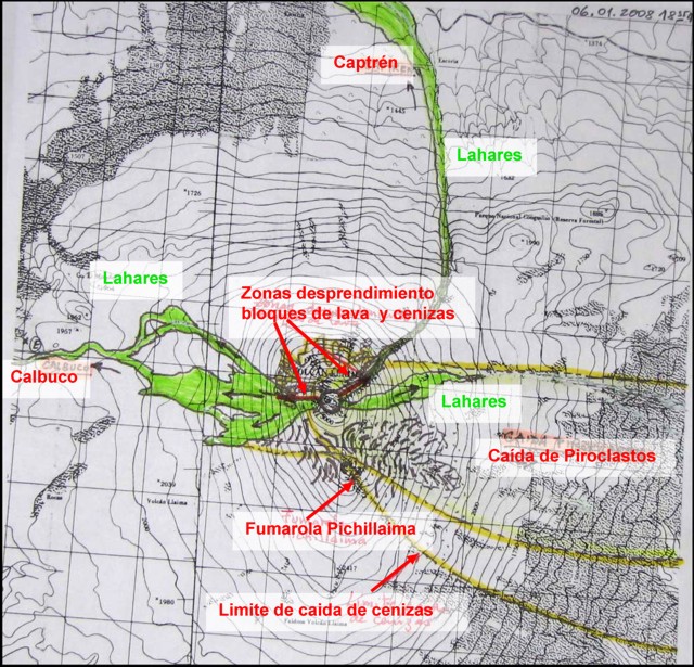 |
Figure 17. Topographic map showing Llaima and features observed during a helicopter overflight on 6 January 2008. The features include lahars (shaded in green), the Calbuco and Captren rivers, detached areas of lava blocks and ashes, fallen pyroclastics, fumaroles, and limit of falling ash (highlighted dashed lines). Courtesy of SERNAGEOMIN. |
SERNAGEOMIN reported that during 10-14 January 2008 seismicity decreased in terms of energy, but increased in the number of events. Based on seismic interpretation, weak explosions produced plumes of gas and ash that drifted NE. On 11 January, the upper surface of lava flows on the W flank that were observed during an overflight were cooled and snow-covered near the crater, but snow-free, and therefore still hot, about 500 m farther downslope. Blocks of incandescent material rolled ~ 1.5 km downslope and caused steam emissions where they contacted the glacier. Abundant cracks in glaciers to the SW of the crater were noted. Based on observations of satellite imagery and pilot reports, the Buenos Aires VAAC reported that ash plumes rose to an altitude of 5.5-6.7 km and drifted NE on 11 January and SW on 13 January.
Eruptive activity continued during the second half of January from the main crater and from two craters and a fissure on the E flank. The main crater contained three active pyroclastic cones. On 16 January one of the craters, ~ 15 m in diameter, produced ash plumes that rose to an altitude of ~ 3.6 km. Glaciers on the NE slope and W flank were fractured and dislocated. Ash plumes rising from the E flank attained an altitude of 4.1 km. Ash emissions vented from a NE-trending fissure ~ 80 m long and ~ 10 m wide. On 16-17 January glowing rocks were emitted from the fissure's NE end; ash plumes caused by rolling rocks rose from multiple areas.
At 0732 on 18 January, an explosion from the E flank sent an ash plume to an altitude of 9.1 km that quickly dispersed NE. People later saw a small lateral explosion from the same area, ash-and-gas emissions from several points, and a new fissure.
On 19 January, an explosion produced an ash plume that rose to an altitude of 4.1 km. An overflight revealed Strombolian activity in the main crater from a new pyroclastic cone that was 120 m in diameter and 100 m high; the cone was absent during a 17 January overflight. A second crater to the SW emitted gas. Sporadic ash emissions were noted from the E sector and an explosion produced a pyroclastic flow and an ash plume that quickly dissipated. On 20 January, another explosion produced an ash plume that rose to an altitude of 4.1 km. Gas and ash emissions were again noted from multiple areas. On 21 January, cloud cover prevented visual observations, but one small ash emission was seen at the end of the day.
On 23 January, a brown ash plume rose to an altitude of 3.5 km and drifted W. Observers on an overflight later that day saw Strombolian eruptions from the pyroclastic cone in the main crater accompanied by emissions of brown ash. A small hornito emitting bluish gas and a lava field were noted between the pyroclastic cone and the inner margins of the crater. Explosions from the E flank were detected on 24 January, and on 26 January steam plumes were observed. Strombolian eruptions in the main crater accompanied by gas and ash emissions continued during through 27 January. Ash plumes rose to altitudes of 3.3-4.1 km and drifted NW, E, SE, and S.
MODVOLC Thermal Alerts. Numerous MODIS thermal anomalies were measured almost daily throughout the month of January 2008 (table 2). As shown by the number of pixels for various observing time, the anomalies covered a particularly large area on 2 January (24 pixels). In contrast, anomalies were absent during the previous intervals of 1 January 2002 through 26 April 2007, and 16 June 2007 through 1 January 2008.
Table 2. Thermal anomalies measured by MODIS/MODVOLC over Llaima from 27 April 2007 through 30 January 2008. No anomalies were detected from 2002 through 26 April 2007, or 16 June 2007 through 1 January 2008. Courtesy of HIGP Thermal Anomalies Team.
| Date | Time (UTC) | Pixels | Satellite |
| 27 Apr 2007 | 1910 | 3 | Aqua |
| 14 Jun 2007 | 1455 | 5 | Terra |
| 15 Jun 2007 | 0515 | 1 | Aqua |
| 02 Jan 2008 | 0250 | 2 | Terra |
| 02 Jan 2008 | 0430 | 9 | Terra |
| 02 Jan 2008 | 0605 | 24 | Aqua |
| 02 Jan 2008 | 1355 | 2 | Terra |
| 02 Jan 2008 | 1535 | 3 | Terra |
| 02 Jan 2008 | 1810 | 2 | Aqua |
| 03 Jan 2008 | 0335 | 4 | Terra |
| 03 Jan 2008 | 0510 | 2 | Aqua |
| 03 Jan 2008 | 1440 | 1 | Terra |
| 03 Jan 2008 | 1850 | 1 | Aqua |
| 04 Jan 2008 | 0555 | 3 | Aqua |
| 05 Jan 2008 | 0320 | 1 | Terra |
| 06 Jan 2008 | 0545 | 1 | Aqua |
| 11 Jan 2008 | 0425 | 1 | Terra |
| 11 Jan 2008 | 0600 | 2 | Aqua |
| 12 Jan 2008 | 0330 | 1 | Terra |
| 14 Jan 2008 | 0630 | 1 | Aqua |
| 15 Jan 2008 | 0400 | 1 | Terra |
| 15 Jan 2008 | 0535 | 1 | Aqua |
| 16 Jan 2008 | 0620 | 2 | Aqua |
| 17 Jan 2008 | 0345 | 1 | Terra |
| 17 Jan 2008 | 0525 | 3 | Aqua |
| 17 Jan 2008 | 1450 | 2 | Terra |
| 18 Jan 2008 | 0605 | 1 | Aqua |
| 20 Jan 2008 | 0555 | 1 | Aqua |
| 22 Jan 2008 | 0405 | 1 | Terra |
| 22 Jan 2008 | 0545 | 2 | Aqua |
| 23 Jan 2008 | 0625 | 1 | Aqua |
| 24 Jan 2008 | 0530 | 3 | Aqua |
| 24 Jan 2008 | 1455 | 1 | Terra |
| 25 Jan 2008 | 0255 | 3 | Terra |
| 25 Jan 2008 | 0615 | 4 | Aqua |
| 26 Jan 2008 | 0340 | 2 | Terra |
| 26 Jan 2008 | 0520 | 2 | Aqua |
| 26 Jan 2008 | 1445 | 1 | Aqua |
| 27 Jan 2008 | 0425 | 2 | Terra |
| 27 Jan 2008 | 0600 | 2 | Aqua |
| 27 Jan 2008 | 1525 | 1 | Terra |
| 28 Jan 2008 | 0330 | 4 | Terra |
| 28 Jan 2008 | 0505 | 4 | Aqua |
| 28 Jan 2008 | 1845 | 1 | Aqua |
| 29 Jan 2008 | 0410 | 4 | Terra |
| 29 Jan 2008 | 0550 | 2 | Aqua |
| 30 Jan 2008 | 0315 | 2 | Terra |
| 30 Jan 2008 | 0630 | 4 | Aqua |
| 30 Jan 2008 | 1420 | 5 | Terra |
| 31 Jan 2008 | 0400 | 6 | Terra |
| 31 Jan 2008 | 0535 | 3 | Aqua |
| 31 Jan 2008 | 1915 | 3 | Aqua |
Information Contacts: Servico Nacional de Geologia y Mineria (SERNAGEOMIN), Avda Sta María N° 0104, Santiago, Chile (URL: http://www.sernageomin.cl/); Buenos Aires Volcanic Ash Advisory Center (VAAC), Servicio Meteorológico Nacional-Fuerza Aérea Argentina, 25 de mayo 658, Buenos Aires, Argentina (URL: http://www.smn.gov.ar/vaac/buenosaires/productos.php); Simon Carn, Joint Center for Earth Systems Technology (JCET), University of Maryland Baltimore County (UMBC); Charles Holliday, U.S. Air Force Weather Agency (AFWA)/XOGM, Offutt Air Force Base, NE 68113, USA; Hawai'i Institute of Geophysics and Planetology (HIGP) Thermal Alerts System, School of Ocean and Earth Science and Technology (SOEST), Univ. of Hawai'i, 2525 Correa Road, Honolulu, HI 96822, USA (URL: http://modis.higp.hawaii.edu/); Associated Press (URL: http://www.ap.org/); United Nations Office for the Coordination of Humanitarian Affairs (OCHA) (URL: https://reliefweb.int/); Antonio Vergara, Temuco, Chile (URL: http://www.flickr.com/people/odiofotolog/).
Summary of January-February 2008 eruption; minor eruptions late March-early April 2008
A report from OVDAS-SERNAGEOMIN (Volcanological Observatory of the Southern Andes ? National Service of Geology and Mining) by Naranjo, Peña, and Moreno (2008) summarized the eruption at Llaima of January through February 2008. This and other reports from OVDAS-SERNAGEOMIN supplements earlier reports (BGVN 33:01) and extends observations through late April 2008.
Summary of January-February 2008 eruption. Shortly after 1730 (local time) on 1 January 2008, Llaima began a new eruptive cycle that was very similar in character to a large eruption that had occurred in February 1957. The 2008 activity was centered at the principal crater, a feature 350 x 450 m in diameter with the major axis trending NW-SE. This new continuous eruptive phase began with strong Strombolian eruptions. Strong ejections of lava fragments fell on the glaciers on the high flanks NE and W of the principal cone (figure 18), generating lahars that flowed ~15 km to reach the Captrén River to the N and the Calbuco River to the W (figure 19). The eruptive plume rose to an altitude of ~ 11 km and blew ESE; ash accumulated to a depth of ~11 cm at a distance of 7 km from the crater.
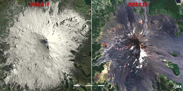 |
Figure 18. Satellite images depicting Llaima before and after the recent eruptions. The left image shows Llaima on 17 September 2006 covered with a white blanket of snow and ice; the right image shows Llaima on 22 February 2008 after numerous eruptions, with ash covering the remnants of the glacier. Courtesy of the Japan Aerospace Exploration Agency-Earth Observation Research Center (JAXA-EORC) Advanced Land-Observing Satellite (ALOS) website. |
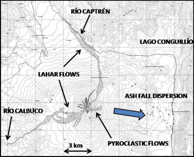 |
Figure 19. Map showing areas of principal effects of the eruption at Llaima on 1 January 2008. Courtesy of OVDAS-SERNAGEOMIN. |
The 1 January 2008 phase was preceded by a slight increase in tremor and a swarm of low frequency earthquakes, but with an absence of volcano-tectonic (VT) or hybrid (HB) events. On 2 January 2008, the activity began to decline. However, a plume of sulfur dioxide (SO2) was tracked by satellite (figure 20).
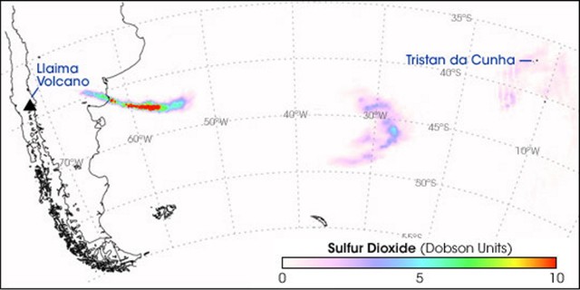 |
Figure 20. A plume of sulfur dioxide (SO2) was released on 2 January 2008. The initially intense plume thinned as it moved E. On 4 January 2008, the plume passed over Tristan da Cunha. This image, acquired by the Ozone Monitoring Instrument (OMI) on NASA's Aura satellite, shows the progress of that plume from 2-4 January 2008. OMI measures the total column amount of SO2 in Dobson Units. (If all the SO2 in a column of atmosphere is compressed into a flat layer at standard temperature (0°C) and pressure (1 atmosphere), a single Dobson Unit of SO2 would measure 0.01 mm in thickness and would contain 0.0285 grams of SO2/m2.) Courtesy, NASA Earth Observatory website. |
An explosion on 7 January 2008 resulted in an ash plume that rose 5 km above the crater and traveled E toward Argentina. This explosion was associated with a low frequency, large magnitude event.
On 9 January, a series of explosions occurred. The seismicity included a swarm of low frequency, high-amplitude events and an abrupt increase in microseismicity that decreased gradually until 14 January and more slowly thereafter. On 18 January, after discrete low frequency tremors, explosions from the crater resulted in a pyroclastic flow on the upper E flank (figure 21).
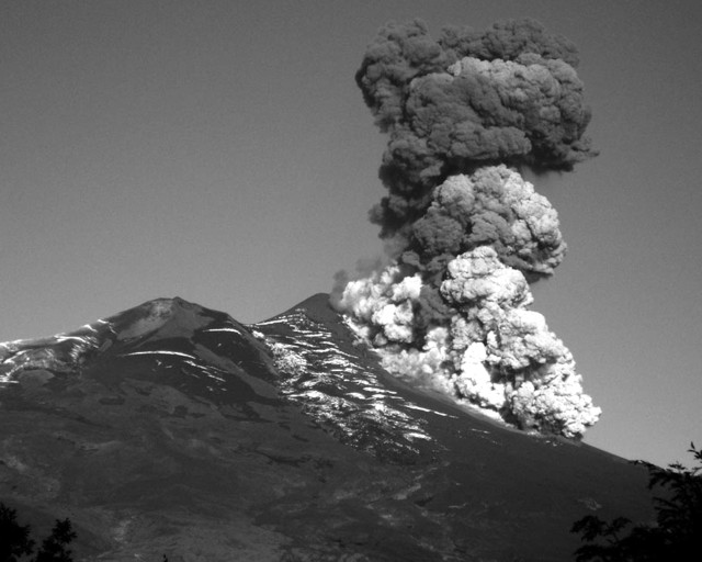 |
Figure 21. Pyroclastic flow on Llaima's E flank on 18 January 2008. Courtesy, OVDAS-SERNAGEOMIN and Gentileza M. Yarur. |
On 21 January seismic activity increased. This was followed on 25 January by continuous Strombolian activity in the main crater. During the night of 26 January, a significant increase in activity occured. Pyroclastic-flow deposits were noted during 28 January on the E flank.
A lava lake that had formed in the main crater began to overflow the W rim on 3 February and a lava flow descended for 2.5 km, making channels in the ice tens of meters deep. The 'a'a lava flow, which was 30-40 m wide and 10 m thick, lasted until 13 February.
Between 8-13 February, explosions in the main crater propelled incandescent material 200-500 m in the air. Explosions occasionally alternated between N and S cones in the main crater. On 9 February, the Calbuco River was about 1 m higher than the normal level, likely due to melt water from the lava and glacier interaction. Strombolian eruptions from the main crater were observed during an overflight on 10 February. A strong explosion ejected bombs onto the E and NE flanks of the volcano on 12 February. Then, on 13 February, incandescence at the summit was noted. Thereafter seismic activity decreased, with only sporadic low frequency signals. The volcano was quiet until 21 February, when a small explosion occurred. Pyroclastic flows were also observed on 21 February descending the E and possibly the W flanks.
During the January-February eruptive phase, various types of plumes were observed, including steam plumes, sulfur dioxide plumes, small ash plumes, and ash-and-gas plumes. The Alert Level remained at Yellow.
March-April 2008. Fumarolic activity from the central pyroclastic cone in Llaima's main crater reactivated on 13 March and intensified during 15-17 March. SO2 plumes rose to an altitude of 3.6 km and drifted E. During 20-21 March, incandescent material propelled from the crater was observed at night.
During 28 March-4 April, fumarolic plumes from Llaima drifted several tens of kilometers, mainly to the SE. Explosions produced ash and gas emissions, and on 4 April, incandescence was reflected in a gas-and-ash plume. An overflight of the main crater on 2 April revealed pyroclastic material and ash and gas emissions, accompanied by small explosions, that originated from three cones.
On 24 April 2008, seismicity from Llaima again increased. Bluish gas (SO2) rose from the main crater, and ash-and-gas plumes associated with explosions rose to an altitude of 4.6 km. No morphological changes to the summit were observed during an overflight on 25 April except for a small increase of the diameter of the SE crater.
Thermal anomalies. Thermal anomalies measured by MODIS in 2008 began with an eruption on 1 January 2008 (BGVN 33:01) and continued almost daily through 13 February (table 3). Following a brief period of no measured anomalies, a new group occurred 30 March through 4 April, after which none were recorded through 1 June 2008. Advanced Spaceborne Thermal Emission and Reflection Radiometer (ASTER) images and reports by ground observers from Projecto Observación Visual Volcán Llaima (POVI) indicated incandescence at the volcano during periods when no anomalies were measured by the MODIS satellites (19-21 March and 24 April 2008), perhaps due to cloud cover. All periods of reported incandescence by ground observers during January 2008 were substantiated by MODIS measured thermal anomalies.
Table 3. MODIS thermal anomalies over Llaima from February through 1 June 2008; data processed by MODVOLC analysis. Daily anomalies were measured from 1-13 February 2008, followed by no anomalies through 29 March. After a period of anomalies from 30 March through 4 April 2008, none were measured through 1 June 2008. Some absences may be due to weather. Courtesy of HIGP Thermal Alerts System.
| Date | Time (UTC) | Pixels | Satellite |
| 01 Feb 2008 | 0305 | 2 | Terra |
| 01 Feb 2008 | 0620 | 2 | Aqua |
| 01 Feb 2008 | 1405 | 1 | Terra |
| 01 Feb 2008 | 1820 | 1 | Aqua |
| 02 Feb 2008 | 0345 | 2 | Terra |
| 02 Feb 2008 | 0525 | 1 | Aqua |
| 02 Feb 2008 | 1450 | 2 | Terra |
| 03 Feb 2008 | 0250 | 4 | Terra |
| 03 Feb 2008 | 0430 | 4 | Terra |
| 03 Feb 2008 | 0605 | 2 | Aqua |
| 03 Feb 2008 | 1355 | 1 | Terra |
| 03 Feb 2008 | 1535 | 2 | Terra |
| 03 Feb 2008 | 1810 | 1 | Aqua |
| 04 Feb 2008 | 0335 | 4 | Terra |
| 04 Feb 2008 | 0510 | 6 | Aqua |
| 04 Feb 2008 | 1850 | 2 | Aqua |
| 05 Feb 2008 | 0415 | 2 | Terra |
| 05 Feb 2008 | 0555 | 4 | Aqua |
| 05 Feb 2008 | 1520 | 2 | Terra |
| 06 Feb 2008 | 0320 | 3 | Terra |
| 06 Feb 2008 | 0500 | 3 | Aqua |
| 06 Feb 2008 | 0640 | 4 | Aqua |
| 06 Feb 2008 | 1425 | 2 | Terra |
| 07 Feb 2008 | 0405 | 4 | Terra |
| 07 Feb 2008 | 0545 | 2 | Aqua |
| 07 Feb 2008 | 1510 | 2 | Terra |
| 08 Feb 2008 | 0625 | 6 | Aqua |
| 08 Feb 2008 | 1415 | 3 | Terra |
| 09 Feb 2008 | 0350 | 3 | Terra |
| 09 Feb 2008 | 0530 | 6 | Aqua |
| 09 Feb 2008 | 1455 | 2 | Terra |
| 09 Feb 2008 | 1910 | 2 | Aqua |
| 10 Feb 2008 | 0255 | 4 | Terra |
| 10 Feb 2008 | 0435 | 4 | Aqua |
| 10 Feb 2008 | 0615 | 5 | Aqua |
| 10 Feb 2008 | 1540 | 4 | Terra |
| 11 Feb 2008 | 0340 | 4 | Terra |
| 11 Feb 2008 | 0520 | 4 | Aqua |
| 11 Feb 2008 | 1445 | 5 | Terra |
| 11 Feb 2008 | 1855 | 1 | Aqua |
| 12 Feb 2008 | 0425 | 4 | Terra |
| 12 Feb 2008 | 0600 | 7 | Aqua |
| 12 Feb 2008 | 1525 | 5 | Terra |
| 12 Feb 2008 | 1940 | 4 | Aqua |
| 13 Feb 2008 | 0330 | 2 | Terra |
| 13 Feb 2008 | 0645 | 2 | Aqua |
| 30 Mar 2008 | 0340 | 1 | Terra |
| 01 Apr 2008 | 0505 | 1 | Aqua |
| 02 Apr 2008 | 0550 | 1 | Aqua |
| 04 Apr 2008 | 0400 | 1 | Terra |
| 04 Apr 2008 | 0535 | 2 | Aqua |
Reference. Naranjo, J.A., Peña, P., and Moreno, H., 2008, Summary of the eruption at Llaima through February 2008: National Service of Geology and Mining (Servico Nacional de Geologia y Mineria - SERNAGEOMIN).
Information Contacts: OVDAS-SERNAGEOMIN (Observatorio Volcanológico de los Andes del Sur-Servico Nacional de Geologia y Mineria) (Southern Andes Volcanological Observatory-National Geology and Mining Service), Avda Sta María 0104, Santiago, Chile (URL: http://www.sernageomin.cl/); NASA Earth Observatory (URL: http://earthobservatory.nasa.gov/); Hawai'i Institute of Geophysics and Planetology (HIGP) Thermal Alerts System, School of Ocean and Earth Science and Technology (SOEST), Univ. of Hawai'i, 2525 Correa Road, Honolulu, HI 96822, USA (URL: http://modis.higp.hawaii.edu/); Buenos Aires Volcanic Ash Advisory Center (VAAC), Servicio Meteorológico Nacional-Fuerza Aérea Argentina, 25 de mayo 658, Buenos Aires, Argentina (URL: http://www.smn.gov.ar/vaac/buenosaires/productos.php); POVI (Projecto Observación Visual Volcán Llaima) (Project of Visual Observation of Llaima Volcano) (URL: http://www.povi.cl/llaima/); Japan Aerospace Exploration Agency-Earth Observation Research Center (JAXA-EORC) (URL: http://www.eorc.jaxa.jp/); ONEMI (Oficina Nacional de Emergencia - Ministerio del Interior) (National Bureau of Emergency - Ministry of Interior), Chile (URL: http://www.onemi.cl/).
Eruption began 1 July 2008; summary of 2007-2008 eruptive cycle
Our previous report on Llaima (BGVN 33:06) described eruptions, tremor, and ash plumes between January-April 2008. This report discusses activity during June-September 2008, including a new eruption beginning 1 July. No reports of activity were received during May 2008.
During 1-20 June 2008, the Southern Andes Volcanological Observatory of the Chile National Service of Geology and Mining (OVDAS-SERNAGEOMIN) reported that sporadic gas-and-ash plumes were observed. More frequent and continuous gas emissions rose from the nested cone in the main crater, and steam plumes rose from the W flank toward the end of this time period.
During 13-16 June, seismicity increased. The National Bureau of Emergency of the Chile Ministry of Interior (ONEMI) reported that, during an overflight on 26 June, bluish gas and ash rose from the top of an active pyroclastic cone and the NE flank no longer was covered with snow.
July 2008 was characterized by several episodic seismic events, followed by periods of relative quiet. On 1 July, a lava flow on the W flank prompted authorities to evacuate about 20-30 people and warn others that additional evacuations might be necessary. The volcano alert level was raised to Yellow (the middle level on a 3-level color system). A lava flow, described as incandescent, descended 800-1000 m along the W flank of the crater, raising concern for lahars in the Calbuca River (figure 22).
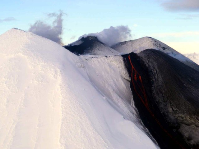 |
Figure 22. From the far SW of the main crater of Llaima a thin stream of lava emanated at a low emission rate on 1 July 2008. At the same time, emanations of continuous volcanic gases and water vapor came from a pyroclastic cone located in the main crater at the top. Courtesy of OVDAS-SERNAGEOMIN. |
During the first week of July, gas-and-ash plumes were emitted from the summit, and the main crater emitted vapor plumes and bluish gas. Fine ashfall was reported in areas nearby, and lahars were generated. On 2 July, an explosion from the summit ejected material to an altitude of 1 km which landed on the SW flank and up to 3.5 km away on the SE flank. OVDAS-SERNAGEOMIN observed incandescence from the 1-km-long lava flow on the W flank. An overflight revealed cooled blocks at the end of the lava flow and a second lava flow (on the SW flank) about 150 m S of the first. The lava flows issued from the base of a pyroclastic cone in the main crater. On 3 July, another overflight revealed that the lava flow on the W flank had advanced and generated a small lahar where lava melted ice on the volcano flanks (figure 23). On 4 July, OVDAS-SERNAGEOMIN characterized the eruptive style as weakly strombolian. A small explosion from the pyroclastic cone in the main crater produced an ash plume that rose 250-400 m and drifted 50 km SE. During 4-5 July, observers reported sporadic explosions and incandescence at the summit. On 6 July seismicity decreased to low levels.
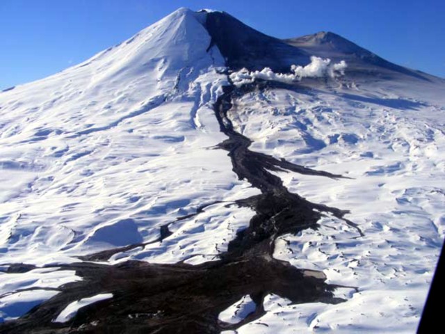 |
Figure 23. A lahar generated from a Llaima lava-flow front that caused ice melting. The lahar expanded into several arms at the front of the wash on the plains of the W flank at an elevation of 1,800 m. Courtesy of OVDAS-SERNAGEOMIN. |
By 7 July the lava emission rate had decreased. At that time, the lava flow on the W flank was about 1.6 km long and the flow on the SW flank was about 2 km long. A new eruptive phase occurred on 10 July (figure 24) when a vigorous Strombolian eruption ejected incandescent pyroclastic material from two vents in the main crater to heights of 500 m above the summit, throwing bombs to the E, NE, and S. Strong activity continued for almost three hours before decreasing. Medium to coarse ash (up to 1.5 mm in diameter) fell in Melipeuco, and lava flows moved toward the W and S flanks. Poor weather prevented observations during the next days.
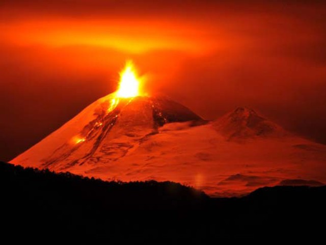 |
Figure 24. The eruptive phase of Llaima of 10 July 2008 as seen from El Manzano (SW). A strong explosion occurred 0555 hr, and three lava flows were observed. Courtesy of Victor Hazeldine. |
On 14 July another episode of increased seismicity accompanied an ash plume that rose to an altitude of 5.6 km. Very intense orange and red incandescence was seen near the summit and at the base of the W flank through breaks in the cloud cover. Later that day, a vigorous strombolian eruption ejected incandescent pyroclastic material from the N crater within the main crater to heights of 500 m above the summit. Seismicity and the intensity of the explosions decreased later that day. On 15 July, diffuse ash emissions rose to an altitude of 3.4 km. Ash and tephra covered areas of the SSE flank.
Seismicity decreased during 16-18 July 2008, but increased again on 19 July. Ash-and-gas plumes rose to an altitude of 3.3 km and drifted SE. The emissions became more intense and frequent. An explosion expelled one ash plume to an altitude of 4.1 km. Ash and tephra fell on the SE flank and in areas near the volcano, and constant explosions ejected incandescent material 500 m above the summit. Steam plumes and lava flows were also observed. Cloud cover prevented observations during 22-23 July.
Another eruptive episode occurred during 26-27 July for a period of 11.5 hours. During that time, Strombolian activity intensified and ejected material 500-800 m above the crater. Rhythmic explosions ejected spatter 1 km above the summit and up to 2 km E. Area residents heard "detonations" from the direction of the volcano. Observers noted gas-and-ash plumes, steam plumes, and a bluish gas emission. One plume rose to an altitude of 10 km. Lava flows emitted at a high rate descended the W and S flanks, producing steam plumes upon contact with ice. This activity prompted SERNAGEOMIN to raise the alert level to Red.
During 28 and 29 July, the volcano was calm, although fumarolic activity and sulfur dioxide plumes were observed. On 31 July, fumarolic activity from the crater was reported in multiple areas around the volcano. Scientists from OVDAS-SERNAGEOMIN observed fumarolic activity from the edges of the nested cones in Llaima's main crater during overflights on 29 July. Sulfur dioxide (SO2) plumes rose from an area in the E crater. Tephra deposits covered parts of the SE flank. Cooled lava flows emitted on 26 and 27 July were noted on the W flank. On 31 July, fumarolic activity from the crater was reported in multiple areas around the volcano. Cloudy conditions prevented visual observations during 1-2 August. On 2 August, as a result of decreased seismic activity, SERNAGEOMIN reduced the volcano alert level to Yellow.
OVDAS-SERNAGEOMIN reported during 8-11 August that fumarolic activity from the snow-free pyroclastic cones in Llaima's main crater was visible during periods of clear weather. Plumes drifted E. A 2-km-long strip on the NE flank was also black in color (snow-free) due to elevated temperatures. On 13 August, gas-and-ash plumes rose to an altitude of 3.3 km and drifted E. Later that day, crater incandescence accompanied the ash emissions.
Steam plumes from the pyroclastic cones in Llaima's main crater were visible during periods of clear weather on 16 August. Evaporation plumes rose from the W flank where lava flows were active in both February and July 2008. On 17 August, sporadic gas-and-ash emissions were observed. Cloud cover prevented observations during 18-20 August. On 21 August, three explosions produced ash plumes that rose to an altitude of 3.6 km and drifted E. Gas and steam was emitted between explosions, and resultant plumes rose to an altitude of 3.4 km and drifted 9 km E. During an overflight, scientists observed steam-and-gas plumes rising from a small crater in the N sector of the main crater. A larger crater, about 100 m in diameter, in the central sector emitted ash. The ash plumes rose to an altitude of 3.4 km and drifted E. A thin layer of ash blanketed the E flank. Ash-and-gas plumes from the main crater drifted W on 22 August. On 23 August, observers reported that incandescent material was ejected less than 1 km above the crater. The next day, an ash plume drifted about 1.5 km SSE. Ash blanketed some areas of the flanks.
Explosions were heard during 25-28 August. On 28 August, seismometer records indicated that gas-and-ash plumes were possibly emitted from the pyroclastic cones in the main crater. Clouds prevented visual observations of Llaima during 29 August-2 September. On 3 September, fumarolic plumes that originated from three points on the pyroclastic cones in the main crater were observed to drift N. An explosion produced an ash plume that also drifted N; ash deposits on the N flank suggested previous emissions. On 4 September gas plumes from the main crater drifted W. Gas-and-steam plumes were emitted during 5-7 September (figure 25).
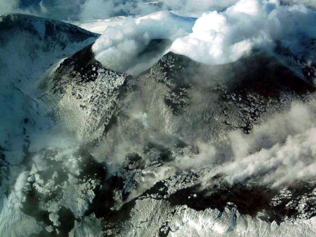 |
Figure 25. Gas emissions, mainly water vapor, rose from the craters at Llaima during 5-7 September 2008. Courtesy of OVDAS- SERNAGEOMIN. |
On 10 September 2008 the volcano alert level for Llaima was lowered to Green due to decreased seismicity and no major emissions. During an overflight on 12 September, OVDAS-SERNAGEOMIN scientists observed diffuse gas-and-steam plumes emitted from the external edges of the nested craters in the main crater (figure 26). During 13-22 September, observers in Melipeuco (about 17 km SSE) reported sporadic gas-and-steam plumes coming from the main crater. During an overflight on 21 September, steam emissions were noted from the NE and W flanks.
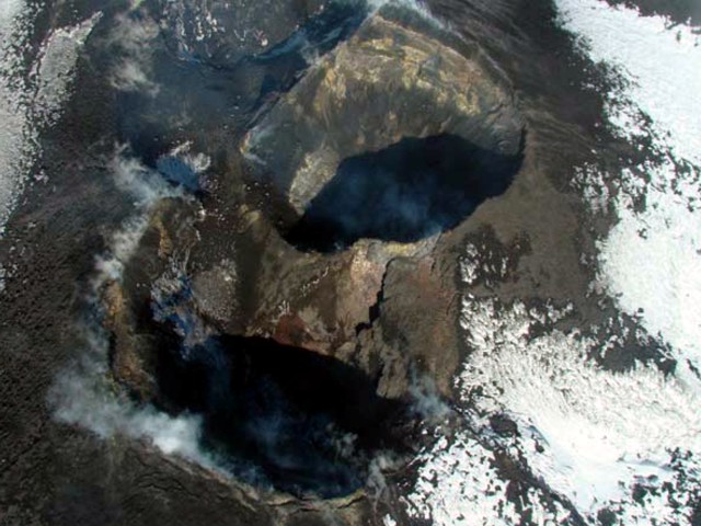 |
Figure 26. An aerial photograph on 12 September 2008 showed the two nested craters within Llaima's main crater. Weak emissions of water vapor and gases emanated from the outer edges of the craters. Courtesy of OVDAS-SERNAGEOMIN. |
Thermal Anomalies. Thermal anomalies at Llaima were measured by satellite-based MODIS/MODVOLC instruments and algorithm (table 4). Anomalies were not observed during the 10 July or 14 July seismic events, perhaps because of poor weather conditions.
Table 4. Thermal anomalies measured at Llaima during July 2008. No anomalies were measured by the MODIS/MODVOLC satellite thermal alert system during June 2008 or from 28 July-1 October 2008. This table is a continuation of the tables from BGVN 33:01 and 33:06. Courtesy of HIGP Thermal Alerts System.
| Date | Time (UTC) | Pixels | Satellite |
| 01 Jul 2008 | 0625 | 1 | Aqua |
| 02 Jul 2008 | 0355 | 3 | Terra |
| 02 Jul 2008 | 0530 | 2 | Aqua |
| 02 Jul 2008 | 1455 | 2 | Terra |
| 03 Jul 2008 | 0435 | 3 | Terra |
| 03 Jul 2008 | 0615 | 3 | Aqua |
| 03 Jul 2008 | 1540 | 2 | Terra |
| 03 Jul 2008 | 1815 | 1 | Aqua |
| 04 Jul 2008 | 0340 | 2 | Terra |
| 19 Jul 2008 | 1815 | 1 | Aqua |
| 27 Jul 2008 | 0345 | 3 | Terra |
Summary of 2007-08 eruptive cycle. In September 2008, OVDAS-SERNAGEOMIN issued a synthesis of the 2007-08 eruptive cycle. The cycle, beginning 26 May 2007, consisted of eight eruptive phases (table 5). Seismic energy was high in phases 5 and 7, but low in phases 6 and 8 (figure 27). Seismic pulses in phase 7 (figure 28) corresponded with lava emissions.
Table 5. Llaima eruptive phases 1-8 and their date ranges as defined by OVDAS-SERNAGEOMIN. The table highly compresses the phases previously described in the Bulletin and presents more details for the phases 7 and 8. Courtesy of OVDAS-SERNAGEOMIN.
| Date Range | Eruptive Phase | Summary of Activity |
| 26 May 2007-31 Dec 2007 | Phase 1 | Characterized by the start of seismic and visual anomalies (BGVN 33:01). |
| 01 Jan 2008-02 Jan 2008 | Phase 2 | Began with a sudden strombolian eruption in the main crater and events that culminated after ~12 hours of intense activity (BGVN 33:01 and 33:06). |
| 02 Jan 2008-21 Jan 2008 | Phase 3 | Consisted of explosions, ash emissions and pyroclastic flows (BGVN 33:01 and 33:06). |
| 21 Jan 2008-02 Feb 2008 | Phase 4 | Included moderate reactivation of the strombolian phase with formation of a small lava lake in the main crater, growth of the internal cone, and formation of several eruptive centers (BGVN 33:01 and 33:06). |
| 02 Feb 2008-13 Feb 2008 | Phase 5 | Characterized by a calm lava emission and some small explosions within the internal pyroclastic cone (BGVN 33:01 and 33:06). |
| 13 Feb 2008-01 Jul 2008 | Phase 6 | Saw noticeable change in the activity of the volcano, characterized by the lack of significant seismic activity and emissions (BGVN 33:06). |
| 01 Jul 2008-27 Jul 2008 | Phase 7 | Included the following five eruptive episodes (figure 28) with brief periods of calm (weak emissions of ash and/or gases): 1) 1-7 July, emissions and small lahars, 2) 10 July, strombolian eruption and lava emission, 3) 14 July, strombolian eruption and lava emission, 4) 19 July, strombolian eruption and lava emission, and 5) 26 July, a vigorous strombolian eruption with a high rate of lava emission. |
| 27 Jul 2008-10 Sep 2008 | Phase 8 | Characterized by sporadic weak ash ejection, pyroclastic cones nested in the main crater continued to give off weak gas emissions. Seismic energy levels as of August 2008 remained low. |
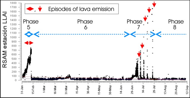 |
Figure 27. Seismic energy in units of RSAM released by Llaima during 31 January-12 September 2008. Downward facing arrows indicate episodes with lava emission; horizontal lined arrows indicate the duration of four eruptive phases (5-8). [Note: RSAM (Real-time Seismic-Amplitude Measurement) sums up the signals from all seismic events during 10-minute intervals to provide a simplified but very useful measure of the overall level of seismic activity for meaningful communication to the public (Ewert and others, 1993)]. Courtesy of OVDAS-SERNAGEOMIN. |
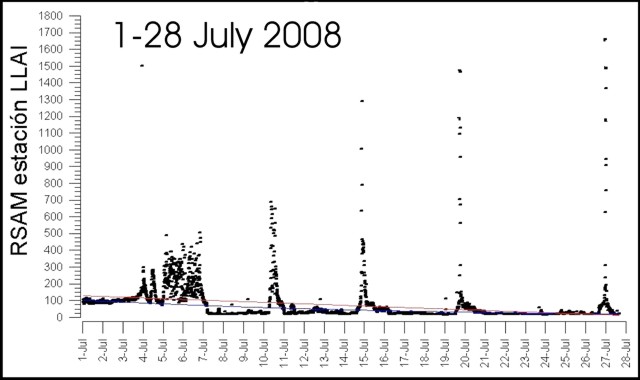 |
Figure 28. Summary of the released seismic energy in units of RSAM during the five eruptive episodes of Phase 7 of Llaima in July 2008. Courtesy of OVDAS-SERNAGEOMIN. |
Reference. Ewert, J.W., Murray, T.L., Lockhart, A.B., and Miller, C.D., 1993, Preventing Volcanic Catastrophe: The U.S. International Volcano Disaster Assistance Program: Earthquakes and Volcanoes, v. 24, no.6.
Information Contacts: OVDAS-SERNAGEOMIN (Observatorio Volcanológico de los Andes del Sur-Servico Nacional de Geologia y Mineria; Southern Andes Volcanological Observatory-National Geology and Mining Service), Avda Sta María No. 0104, Santiago, Chile (URL: http://www.sernageomin.cl/); NASA Earth Observatory (URL: http://earthobservatory.nasa.gov/); Hawai'i Institute of Geophysics and Planetology (HIGP) Thermal Alerts System, School of Ocean and Earth Science and Technology (SOEST), Univ. of Hawai'i, 2525 Correa Road, Honolulu, HI 96822, USA (URL: http://modis.higp.hawaii.edu/); Oficina Nacional de Emergencia (ONEMI), Ministerio del Interior, Chile (URL: http://www.onemi.cl/).
Substantial April 2009 eruption had three lava flows
A new eruptive episode began at Llaima on 1 July 2008 (BGVN 33:08) when a lava flow was seen moving down the W flank and sporadic ash explosions originated from the summit area. Activity continued through most of July, but after an episode of Strombolian activity on 26-27 July only fumarolic emissions were reported by scientists from the Southern Andes Volcanological Observatory (OVDAS) of the Chile National Service of Geology and Mining (SERNAGEOMIN). Additional ash explosions began in the second half of August before the volcano quieted again after 3 September (BGVN 33:08).
During an overflight on 12 September OVDAS scientists observed diffuse gas-and-steam emissions from the external edges of the nested craters in the main crater. Observers in Melipeuco (~ 17 km SSE) reported sporadic gas-and-steam emissions from the main crater the following week of 13-22 September. During another overflight on 21 September, steaming was noted from the NE and W flanks.
OVDAS reported that from 19 to 25 November 2008, observers in the area reported weak and sporadic emissions of water vapor concentrated around the two small craters of the paired pyroclastic cones nested inside the main crater. During this period there had been a slight increase both in the energy and number of long-period earthquakes. Seismic instrumentation was located 20 km from the volcano. A few episodes of short duration tremor (averaging 20 RSAM units) along with weak and occasional steam emissions suggested that the seismicity was of superficial origin.
On 11 December two small debris avalanches descended the W flank through an ice channel. Fumarolic activity gradually increased after mid-December; on 22 December there were two weak ash emissions. Meltwater from heavy snowfall on the preceding day was probably responsible for this phreatomagmatic activity.
On 3 January 2009 the two monitoring cameras captured a total of 37 phreatomagmatic explosions over about 14 hours; the plumes of gases and tephra rose 100 m before becoming disconnected from their source. The emissions came from three distinct points within the intra-crater cone. On two occasions spatters of lava impacted the slope of the intra-crater cone and its base. Rockfalls also descended the SE flank of Pichillaima cone, Llaima's secondary summit.
On 2-3 April 2009, OVDAS reported that seismicity from Llaima increased in frequency and amplitude and evolved into continuous tremor. Steam plumes with small amounts of ash were emitted. Late on 3 April, observers reported incandescence from the main crater. Weak Strombolian explosions were produced in the N cone inside the crater. Five settlements were put on alert, including Vilcun and Curacautin, where late on 4 April evacuations began due to lava and ash eruptions. That day, rhythmic Strombolian explosions occurred in the main crater from two nested pyroclastic cones. Incandescent tephra was ejected ~ 700 m above the crater. The Alert Level was raised to Red, the highest state, and the surrounding Conguillio National Park was closed.
The Oficina Nacional de Emergencia, Ministerio del Interior, (ONEMI) reported that, on 4 April, fine ash fell in Lago Lake in the Conguillío National Park and a lava flow 1 km long traveled W towards the Calbuco River. Access to local parks was restricted and 12 people self-evacuated. Later that day, authorities evacuated 71 additional people in high-risk areas, mainly due to the potential for lahars along the Calbuco River and other waterways swollen with volcanic ash.
OVDAS reported that Strombolian activity continued on 5 April (figure 29). A dark gray ash plume drifted E; heavy ashfall was reported in Lago Verde. A lahar traveled NNE down the Captrén River and lava continued to travel down the W flank. On 6 April continuous explosions were observed from Melipeuco (17 km SSE). Lahars again traveled down the Captrén River. Occasionally, gas-and-ash plumes were seen which drifted E and ash fell in areas to the E. Heavy ashfall and lapilli up to 1.5 cm in diameter fell in the National Park areas between Conguillio Lake 10 km ENE, and the Arcoiris Lake less than 10 km ENE.
|
Figure 29. Photo of Strombolian activity from the intra-crater cones at Llaima on 5 April 2009. Courtesy of Reuters. |
After 6 April activity declined quickly until reaching a low level characterized by small amounts of ash emissions. On 7 April, gas and ash emitted from multiple points formed a plume that rose ~ 1 km above the summit and drifted NE. The flanks were covered with bombs, lapilli, and ash. An overflight on 7 April observed the main crater completely obscured by a large pyroclastic cone with four inactive craters. Two lava flows descended the W flank. The more southerly lava flow was about 4.5 km long and melted part of the glacier, causing a lahar towards the Calbuco River. The more northerly lava flow was similar in length, and branched off into two 1-km-long flows; it also caused a lahar. On the NE flank, a lava flow that originated from the base of the pyroclastic cone caused lahars that descended into the valley between Curacautín (30 km NNW) and the Conguillío National Park.
During 7-10 April, there was intermittent incandescence from a lava flow at the SW base of the pyroclastic cone. Incandescent blocks originating from the lava flow descended W. On 8 April, gasses emitted from multiple points on the pyroclastic cone formed a plume that drifted NE. Preliminary calculations indicated that the height of the pyroclastic cone exceeded the top of the main crater by ~ 70 m, making the new summit elevation 3,240 m. During 9-10 and 13-14 April, gas and steam plumes rose from the pyroclastic cone; on 14 April, fumarolic activity from the pyroclastic cone was again noted. On 16 April, NASA's Earth Observing-1 satellite passed overhead and documented areas of ash-covered snow W of the summit.
On 24 April ash plumes originating from an area ~ 700 m down the E flank rose ~ 500 m and drifted E. Steam emissions that accompanied the ash plumes indicated that the point of activity came from underneath the glacier. The activity lasted about 1.5 hours. During 28 April-11 May, OVDAS reported sporadic incandescence from an area in the SW part of the main crater. Blocks occasionally rolling down the W flank were seen on a web camera.
During 5-11 May, tephra was ejected from an area on the E flank and, during the night, incandescence originated from this area. During the daytime, observers reported that an almost continuous orange brown plume rose ~ 200 m. Sporadic incandescence also came from an area in the SW part of Llaima's main crater, corresponding to a small active outcrop of lava. Steam plumes rose from the same area continued until 18 May. MODVOLC data reflects the dramatic thermal activity between 4 April and 14 April.
On 26 May 2009, after a period of unusually heavy rain, a 500 m-long fissure on Lliama's the upper E flank began to emit dense steam clouds. On the following day, small amounts of ash were observed mixed in with the water vapor, and on 28 May both the amount of vapor and the ash content increased. On 1 June, after further bad weather, the energy of the intermittent emissions along the fissure further increased. A powerful phreatic eruption began at 1120. The eruption ceased by 1200, and during that afternoon only one small subsequent eruption was observed. Since the phreatic fissure eruptions began, seismicity had remained at normal levels but the number and energy of LP (long period) earthquakes had increased.
During an overflight of Llaima on 1 June 2009 observers reported a 2 km2 area with an elevated temperature on the E flank. Several small areas emitted gas, and a small cone was forming ~ 800 m below the crater. The observers also saw an E-trending, ~ 300m-long fissure located 200 m from the main crater's rim. Brown ash and steam plumes were emitted from different areas of the fissure. The irregularly-shaped summit crater had a few weak fumaroles. During 5-8 June, OVDAS reported increased seismic tremor. Incandescence from an area in the SW part of Llaima's main crater continued to correspond to a small active outcrop of lava. On 6 June, incandescence emanated from a small point along the E-flank fissure. Gas and steam was emitted from an area W of the main crater. The camera in Melipueco again showed glow on the NW inner margin of the main crater during 9-16 June, and occasional steam emissions with minor amounts of ash were also seen from the E flank. From 12 June on there was no evidence of lateral or summit eruption, although inclement weather masked views of the mountain.
An OVDAS report dated 3 July 2009 indicated that seismicity remained similar to the previous week, although there was an increase in the number of low amplitude long-period earthquakes, up to 40/hour. However, they detected two to three higher-energy earthquakes per day; along with weak tremor. A continuing increase of the long-period type earthquakes observed during the previous three days was interpreted to indicate the potential for an eruptive event. Only steam was visible in sectors where previously there have been lava flows.
On 14 November 2009, cameras operated by OVDAS showed steam-and-gas plumes rising from the main crater and E flank. These emissions continued until 1 December. Although seismicity generally decreased, a new type of long-period, low-frequency earthquake was detected. An overflight on 4 December revealed fumarolic activity and some SO2 emissions coming mainly from fissures on the N crater wall and outer E and W flanks.
During 20 January-9 February 2010, cameras showed steam-and-gas plumes rising from the main crater. Seismic signals (tremor and volcano-tectonic earthquakes) had characteristics that indicated fluid movement. On 22 January 2010, OVDAS reported that seismicity had decreased during the previous few weeks to background levels.
OVDAS reported that on 4 March 2010 seismicity increased. During an overflight that same day, scientists observed emissions of gas and steam from the main crater. Photographs were compared to those taken on 21 February and showed no significant changes in morphology. The rate of sulfur dioxide emissions had increased, however. Scientists also noted deposits from a large rockfall along with fracturing of the glacier, especially on the upper N and NW flanks. During 5-22 March seismicity generally decreased to levels characteristic prior to the 27 February earthquake; however a significant number of earthquakes that indicated fluid movement in the volcano continued to be registered. Gas-and-steam plumes rose 100 m from their source.
On 15 April 2010 seismicity increased and tremor was detected; however, OVDAS reported that during 1-14 May seismicity decreased to moderate levels. Small white fumaroles that rose from the main crater were seen through web cameras.
Information Contacts: Observatorio Volcanológico de los Andes del Sur (OVDAS), Observatorio Volcanológico de los Andes del Sur-Servico Nacional de Geologia y Mineria; Southern Andes Volcanological Observatory-National Geology and Mining Service (SERNAGEOMIN), Avda Sta María No. 0104, Santiago, Chile; Oficina Nacional de Emergencia - Ministerio del Interior (ONEMI), Ministerio del Interior, Chile (URL: http://www.onemi.cl/); NASA Earth Observatory (URL: http://earthobservatory.nasa.gov/); ; Hawai'i Institute of Geophysics and Planetology (HIGP) Thermal Alerts System, School of Ocean and Earth Science and Technology (SOEST), Univ. of Hawai'i, 2525 Correa Road, Honolulu, HI 96822, USA (URL: http://modis.higp.hawaii.edu/); Reuters (URL: http://www.reuters.com/).
This compilation of synonyms and subsidiary features may not be comprehensive. Features are organized into four major categories: Cones, Craters, Domes, and Thermal Features. Synonyms of features appear indented below the primary name. In some cases additional feature type, elevation, or location details are provided.
Synonyms |
||||
| Llaymas | Yaima | Imperial | Chayll | Chinal | Chanel | Aliante | Anonimo | Yaimas | ||||
Craters |
||||
| Feature Name | Feature Type | Elevation | Latitude | Longitude |
| Chome | Crater | |||
| Coigue | Crater | |||
| Colorado | Crater | |||
| Conguillio Group | Crater | |||
| Japones | Crater | |||
| Mirador | Crater | |||
|
|
||||||||||||||||||||||||||
There is data available for 56 confirmed Holocene eruptive periods.
2008 Jan 1 - 2009 Jun 12 ± 4 days Confirmed Eruption Max VEI: 3
| Episode 1 | Eruption Episode | Summit and upper east flank | ||||||||||||||||||||||||||||||||||||||||||||||||||||||||||||||||||||||||||||||||||||
|---|---|---|---|---|---|---|---|---|---|---|---|---|---|---|---|---|---|---|---|---|---|---|---|---|---|---|---|---|---|---|---|---|---|---|---|---|---|---|---|---|---|---|---|---|---|---|---|---|---|---|---|---|---|---|---|---|---|---|---|---|---|---|---|---|---|---|---|---|---|---|---|---|---|---|---|---|---|---|---|---|---|---|---|---|---|
| 2008 Jan 1 - 2009 Jun 12 ± 4 days | Evidence from Observations: Reported | ||||||||||||||||||||||||||||||||||||||||||||||||||||||||||||||||||||||||||||||||||||
|
List of 15 Events for Episode 1 at Summit and upper east flank
| |||||||||||||||||||||||||||||||||||||||||||||||||||||||||||||||||||||||||||||||||||||
2007 May 26 - 2007 Aug 8 (?) Confirmed Eruption Max VEI: 2
| Episode 1 | Eruption Episode | |||||||||||||||||||||||||
|---|---|---|---|---|---|---|---|---|---|---|---|---|---|---|---|---|---|---|---|---|---|---|---|---|---|
| 2007 May 26 - 2007 Aug 8 (?) | Evidence from Observations: Reported | ||||||||||||||||||||||||
|
List of 3 Events for Episode 1
| |||||||||||||||||||||||||
2003 Apr 9 - 2003 Apr 16 (in or after) Confirmed Eruption Max VEI: 2
| Episode 1 | Eruption Episode | |||||||||||||||||||||||||||||||||||
|---|---|---|---|---|---|---|---|---|---|---|---|---|---|---|---|---|---|---|---|---|---|---|---|---|---|---|---|---|---|---|---|---|---|---|---|
| 2003 Apr 9 - 2003 Apr 16 (in or after) | Evidence from Observations: Reported | ||||||||||||||||||||||||||||||||||
|
List of 5 Events for Episode 1
| |||||||||||||||||||||||||||||||||||
2002 Oct 13 ± 12 days Confirmed Eruption Max VEI: 1
| Episode 1 | Eruption Episode | |||||||||||||||||||||||||
|---|---|---|---|---|---|---|---|---|---|---|---|---|---|---|---|---|---|---|---|---|---|---|---|---|---|
| 2002 Oct 13 ± 12 days - Unknown | Evidence from Observations: Reported | ||||||||||||||||||||||||
|
List of 3 Events for Episode 1
| |||||||||||||||||||||||||
1998 Nov 10 ± 3 days Confirmed Eruption Max VEI: 2
| Episode 1 | Eruption Episode | |||||||||||||||||||||||||
|---|---|---|---|---|---|---|---|---|---|---|---|---|---|---|---|---|---|---|---|---|---|---|---|---|---|
| 1998 Nov 10 ± 3 days - Unknown | Evidence from Observations: Reported | ||||||||||||||||||||||||
|
List of 3 Events for Episode 1
| |||||||||||||||||||||||||
1998 Apr 3 - 1998 Apr 23 (?) Confirmed Eruption Max VEI: 2 (?)
| Episode 1 | Eruption Episode | |||||||||||||||||||||||||||||||||||
|---|---|---|---|---|---|---|---|---|---|---|---|---|---|---|---|---|---|---|---|---|---|---|---|---|---|---|---|---|---|---|---|---|---|---|---|
| 1998 Apr 3 - 1998 Apr 23 (?) | Evidence from Observations: Reported | ||||||||||||||||||||||||||||||||||
|
List of 5 Events for Episode 1
| |||||||||||||||||||||||||||||||||||
1997 Mar 16 (?) ± 15 days - 1997 Oct 16 (?) ± 15 days Confirmed Eruption Max VEI: 1
| Episode 1 | Eruption Episode | |||||||||||||||||||||||||
|---|---|---|---|---|---|---|---|---|---|---|---|---|---|---|---|---|---|---|---|---|---|---|---|---|---|
| 1997 Mar 16 (?) ± 15 days - 1997 Oct 16 (?) ± 15 days | Evidence from Observations: Reported | ||||||||||||||||||||||||
|
List of 3 Events for Episode 1
| |||||||||||||||||||||||||
1995 Oct 13 - 1995 Oct 22 (in or after) Confirmed Eruption Max VEI: 2 (?)
| Episode 1 | Eruption Episode | ||||||||||||||||||||||||||||||||||||||||
|---|---|---|---|---|---|---|---|---|---|---|---|---|---|---|---|---|---|---|---|---|---|---|---|---|---|---|---|---|---|---|---|---|---|---|---|---|---|---|---|---|
| 1995 Oct 13 - 1995 Oct 22 (in or after) | Evidence from Observations: Reported | |||||||||||||||||||||||||||||||||||||||
|
List of 6 Events for Episode 1
| ||||||||||||||||||||||||||||||||||||||||
1994 May 17 - 1994 Aug 30 Confirmed Eruption Max VEI: 2
| Episode 1 | Eruption Episode | SE side summit crater, upper SW flank | |||||||||||||||||||||||||||||||||||||||||||||||||||||||||||
|---|---|---|---|---|---|---|---|---|---|---|---|---|---|---|---|---|---|---|---|---|---|---|---|---|---|---|---|---|---|---|---|---|---|---|---|---|---|---|---|---|---|---|---|---|---|---|---|---|---|---|---|---|---|---|---|---|---|---|---|---|
| 1994 May 17 - 1994 Aug 30 | Evidence from Observations: Reported | |||||||||||||||||||||||||||||||||||||||||||||||||||||||||||
|
List of 10 Events for Episode 1 at SE side summit crater, upper SW flank
| ||||||||||||||||||||||||||||||||||||||||||||||||||||||||||||
1992 Aug 23 - 1992 Sep 2 Confirmed Eruption Max VEI: 1
| Episode 1 | Eruption Episode | |||||||||||||||||||||||||||||||||||
|---|---|---|---|---|---|---|---|---|---|---|---|---|---|---|---|---|---|---|---|---|---|---|---|---|---|---|---|---|---|---|---|---|---|---|---|
| 1992 Aug 23 - 1992 Sep 2 | Evidence from Observations: Reported | ||||||||||||||||||||||||||||||||||
|
List of 5 Events for Episode 1
| |||||||||||||||||||||||||||||||||||
1990 Feb 25 - 1990 Nov 25 Confirmed Eruption Max VEI: 1
| Episode 1 | Eruption Episode | ||||||||||||||||||||||||||||||
|---|---|---|---|---|---|---|---|---|---|---|---|---|---|---|---|---|---|---|---|---|---|---|---|---|---|---|---|---|---|---|
| 1990 Feb 25 - 1990 Nov 25 | Evidence from Observations: Reported | |||||||||||||||||||||||||||||
|
List of 4 Events for Episode 1
| ||||||||||||||||||||||||||||||
1984 Apr 20 - 1984 Nov 26 Confirmed Eruption Max VEI: 2
| Episode 1 | Eruption Episode | ||||||||||||||||||||||||||||||||||||||||
|---|---|---|---|---|---|---|---|---|---|---|---|---|---|---|---|---|---|---|---|---|---|---|---|---|---|---|---|---|---|---|---|---|---|---|---|---|---|---|---|---|
| 1984 Apr 20 - 1984 Nov 26 | Evidence from Observations: Reported | |||||||||||||||||||||||||||||||||||||||
|
List of 6 Events for Episode 1
| ||||||||||||||||||||||||||||||||||||||||
1979 Oct 15 - 1979 Nov 28 Confirmed Eruption Max VEI: 2
| Episode 1 | Eruption Episode | ||||||||||||||||||||||||||||||||||||||||||||||||||
|---|---|---|---|---|---|---|---|---|---|---|---|---|---|---|---|---|---|---|---|---|---|---|---|---|---|---|---|---|---|---|---|---|---|---|---|---|---|---|---|---|---|---|---|---|---|---|---|---|---|---|
| 1979 Oct 15 - 1979 Nov 28 | Evidence from Observations: Reported | |||||||||||||||||||||||||||||||||||||||||||||||||
|
List of 8 Events for Episode 1
| ||||||||||||||||||||||||||||||||||||||||||||||||||
1971 Dec 1 ± 30 days - 1972 Mar 12 Confirmed Eruption Max VEI: 2
| Episode 1 | Eruption Episode | |||||||||||||||||||||||||
|---|---|---|---|---|---|---|---|---|---|---|---|---|---|---|---|---|---|---|---|---|---|---|---|---|---|
| 1971 Dec 1 ± 30 days - 1972 Mar 12 | Evidence from Observations: Reported | ||||||||||||||||||||||||
|
List of 3 Events for Episode 1
| |||||||||||||||||||||||||
1964 Jul 2 ± 182 days Confirmed Eruption Max VEI: 2
| Episode 1 | Eruption Episode | ||||||||||||||||||||||||||||||
|---|---|---|---|---|---|---|---|---|---|---|---|---|---|---|---|---|---|---|---|---|---|---|---|---|---|---|---|---|---|---|
| 1964 Jul 2 ± 182 days - Unknown | Evidence from Observations: Reported | |||||||||||||||||||||||||||||
|
List of 4 Events for Episode 1
| ||||||||||||||||||||||||||||||
[ 1960 Jul 2 ± 182 days ] Uncertain Eruption
| Episode 1 | Eruption Episode | ||||
|---|---|---|---|---|
| 1960 Jul 2 ± 182 days - Unknown | Evidence from Unknown | |||
1955 Oct 22 - 1957 Nov 16 ± 15 days Confirmed Eruption Max VEI: 3
| Episode 1 | Eruption Episode | Summit and SE crater | |||||||||||||||||||||||||||||||||||||||||||||||||
|---|---|---|---|---|---|---|---|---|---|---|---|---|---|---|---|---|---|---|---|---|---|---|---|---|---|---|---|---|---|---|---|---|---|---|---|---|---|---|---|---|---|---|---|---|---|---|---|---|---|---|
| 1955 Oct 22 - 1957 Nov 16 ± 15 days | Evidence from Observations: Reported | |||||||||||||||||||||||||||||||||||||||||||||||||
|
List of 8 Events for Episode 1 at Summit and SE crater
| ||||||||||||||||||||||||||||||||||||||||||||||||||
1949 Sep Confirmed Eruption Max VEI: 2
| Episode 1 | Eruption Episode | ||||||||||||||||||||||||||||||
|---|---|---|---|---|---|---|---|---|---|---|---|---|---|---|---|---|---|---|---|---|---|---|---|---|---|---|---|---|---|---|
| 1949 Sep - Unknown | Evidence from Observations: Reported | |||||||||||||||||||||||||||||
|
List of 4 Events for Episode 1
| ||||||||||||||||||||||||||||||
1946 Jul 23 Confirmed Eruption Max VEI: 2
| Episode 1 | Eruption Episode | ||||||||||||||||||||||||||||||||||||||||
|---|---|---|---|---|---|---|---|---|---|---|---|---|---|---|---|---|---|---|---|---|---|---|---|---|---|---|---|---|---|---|---|---|---|---|---|---|---|---|---|---|
| 1946 Jul 23 - Unknown | Evidence from Observations: Reported | |||||||||||||||||||||||||||||||||||||||
|
List of 6 Events for Episode 1
| ||||||||||||||||||||||||||||||||||||||||
1945 Mar 31 - 1945 Apr 3 Confirmed Eruption Max VEI: 3
| Episode 1 | Eruption Episode | ||||||||||||||||||||||||||||||||||||||||||||||||||
|---|---|---|---|---|---|---|---|---|---|---|---|---|---|---|---|---|---|---|---|---|---|---|---|---|---|---|---|---|---|---|---|---|---|---|---|---|---|---|---|---|---|---|---|---|---|---|---|---|---|---|
| 1945 Mar 31 - 1945 Apr 3 | Evidence from Observations: Reported | |||||||||||||||||||||||||||||||||||||||||||||||||
|
List of 8 Events for Episode 1
| ||||||||||||||||||||||||||||||||||||||||||||||||||
1944 Confirmed Eruption Max VEI: 2
| Episode 1 | Eruption Episode | |||||||||||||||||||||||||||||||||||
|---|---|---|---|---|---|---|---|---|---|---|---|---|---|---|---|---|---|---|---|---|---|---|---|---|---|---|---|---|---|---|---|---|---|---|---|
| 1944 - Unknown | Evidence from Observations: Reported | ||||||||||||||||||||||||||||||||||
|
List of 5 Events for Episode 1
| |||||||||||||||||||||||||||||||||||
1942 Jun 9 - 1942 Nov Confirmed Eruption Max VEI: 2
| Episode 1 | Eruption Episode | ||||||||||||||||||||||||||||||
|---|---|---|---|---|---|---|---|---|---|---|---|---|---|---|---|---|---|---|---|---|---|---|---|---|---|---|---|---|---|---|
| 1942 Jun 9 - 1942 Nov | Evidence from Observations: Reported | |||||||||||||||||||||||||||||
|
List of 4 Events for Episode 1
| ||||||||||||||||||||||||||||||
1941 Jun 23 Confirmed Eruption Max VEI: 2
| Episode 1 | Eruption Episode | |||||||||||||||||||||||||
|---|---|---|---|---|---|---|---|---|---|---|---|---|---|---|---|---|---|---|---|---|---|---|---|---|---|
| 1941 Jun 23 - Unknown | Evidence from Observations: Reported | ||||||||||||||||||||||||
|
List of 3 Events for Episode 1
| |||||||||||||||||||||||||
1938 Dec Confirmed Eruption Max VEI: 1
| Episode 1 | Eruption Episode | |||||||||||||||||||||||||
|---|---|---|---|---|---|---|---|---|---|---|---|---|---|---|---|---|---|---|---|---|---|---|---|---|---|
| 1938 Dec - Unknown | Evidence from Observations: Reported | ||||||||||||||||||||||||
|
List of 3 Events for Episode 1
| |||||||||||||||||||||||||
1937 Feb 9 (?) - 1937 Nov 2 Confirmed Eruption Max VEI: 2
| Episode 1 | Eruption Episode | |||||||||||||||||||||||||||||||||||||||||||||||||||||||
|---|---|---|---|---|---|---|---|---|---|---|---|---|---|---|---|---|---|---|---|---|---|---|---|---|---|---|---|---|---|---|---|---|---|---|---|---|---|---|---|---|---|---|---|---|---|---|---|---|---|---|---|---|---|---|---|
| 1937 Feb 9 (?) - 1937 Nov 2 | Evidence from Observations: Reported | ||||||||||||||||||||||||||||||||||||||||||||||||||||||
|
List of 9 Events for Episode 1
| |||||||||||||||||||||||||||||||||||||||||||||||||||||||
1932 Dec 31 - 1933 Jan 5 Confirmed Eruption Max VEI: 3
| Episode 1 | Eruption Episode | |||||||||||||||||||||||||||||||||||
|---|---|---|---|---|---|---|---|---|---|---|---|---|---|---|---|---|---|---|---|---|---|---|---|---|---|---|---|---|---|---|---|---|---|---|---|
| 1932 Dec 31 - 1933 Jan 5 | Evidence from Observations: Reported | ||||||||||||||||||||||||||||||||||
|
List of 5 Events for Episode 1
| |||||||||||||||||||||||||||||||||||
1932 Mar 2 - 1932 Mar 2 Confirmed Eruption Max VEI: 2 (?)
| Episode 1 | Eruption Episode | ||||||||||||||||||||||||||||||
|---|---|---|---|---|---|---|---|---|---|---|---|---|---|---|---|---|---|---|---|---|---|---|---|---|---|---|---|---|---|---|
| 1932 Mar 2 - 1932 Mar 2 | Evidence from Observations: Reported | |||||||||||||||||||||||||||||
|
List of 4 Events for Episode 1
| ||||||||||||||||||||||||||||||
1930 Jul 6 - 1930 Aug 20 Confirmed Eruption Max VEI: 2
| Episode 1 | Eruption Episode | ||||||||||||||||||||||||||||||
|---|---|---|---|---|---|---|---|---|---|---|---|---|---|---|---|---|---|---|---|---|---|---|---|---|---|---|---|---|---|---|
| 1930 Jul 6 - 1930 Aug 20 | Evidence from Observations: Reported | |||||||||||||||||||||||||||||
|
List of 4 Events for Episode 1
| ||||||||||||||||||||||||||||||
1929 Dec Confirmed Eruption Max VEI: 2
| Episode 1 | Eruption Episode | ||||||||||||||||||||||||||||||
|---|---|---|---|---|---|---|---|---|---|---|---|---|---|---|---|---|---|---|---|---|---|---|---|---|---|---|---|---|---|---|
| 1929 Dec - Unknown | Evidence from Observations: Reported | |||||||||||||||||||||||||||||
|
List of 4 Events for Episode 1
| ||||||||||||||||||||||||||||||
1927 Oct 5 - 1927 Dec 5 Confirmed Eruption Max VEI: 2
| Episode 1 | Eruption Episode | SE crater and summit crater | ||||||||||||||||||||||||||||||||||||||||||||||||||||||
|---|---|---|---|---|---|---|---|---|---|---|---|---|---|---|---|---|---|---|---|---|---|---|---|---|---|---|---|---|---|---|---|---|---|---|---|---|---|---|---|---|---|---|---|---|---|---|---|---|---|---|---|---|---|---|---|
| 1927 Oct 5 - 1927 Dec 5 | Evidence from Observations: Reported | ||||||||||||||||||||||||||||||||||||||||||||||||||||||
|
List of 9 Events for Episode 1 at SE crater and summit crater
| |||||||||||||||||||||||||||||||||||||||||||||||||||||||
1922 Oct 24 Confirmed Eruption Max VEI: 2
| Episode 1 | Eruption Episode | ||||||||||||||||||||||||||||||
|---|---|---|---|---|---|---|---|---|---|---|---|---|---|---|---|---|---|---|---|---|---|---|---|---|---|---|---|---|---|---|
| 1922 Oct 24 - Unknown | Evidence from Observations: Reported | |||||||||||||||||||||||||||||
|
List of 4 Events for Episode 1
| ||||||||||||||||||||||||||||||
1917 Feb 4 Confirmed Eruption Max VEI: 2
| Episode 1 | Eruption Episode | |||||||||||||||||||||||||
|---|---|---|---|---|---|---|---|---|---|---|---|---|---|---|---|---|---|---|---|---|---|---|---|---|---|
| 1917 Feb 4 - Unknown | Evidence from Observations: Reported | ||||||||||||||||||||||||
|
List of 3 Events for Episode 1
| |||||||||||||||||||||||||
1914 Jul 3 Confirmed Eruption Max VEI: 2
| Episode 1 | Eruption Episode | ||||||||||||||||||||||||||||||
|---|---|---|---|---|---|---|---|---|---|---|---|---|---|---|---|---|---|---|---|---|---|---|---|---|---|---|---|---|---|---|
| 1914 Jul 3 - Unknown | Evidence from Observations: Reported | |||||||||||||||||||||||||||||
|
List of 4 Events for Episode 1
| ||||||||||||||||||||||||||||||
1912 Confirmed Eruption Max VEI: 2
| Episode 1 | Eruption Episode | ||||||||||||||||||||||||||||||
|---|---|---|---|---|---|---|---|---|---|---|---|---|---|---|---|---|---|---|---|---|---|---|---|---|---|---|---|---|---|---|
| 1912 - Unknown | Evidence from Observations: Reported | |||||||||||||||||||||||||||||
|
List of 4 Events for Episode 1
| ||||||||||||||||||||||||||||||
1907 - 1908 Mar Confirmed Eruption Max VEI: 2
| Episode 1 | Eruption Episode | ||||||||||||||||||||||||||||||
|---|---|---|---|---|---|---|---|---|---|---|---|---|---|---|---|---|---|---|---|---|---|---|---|---|---|---|---|---|---|---|
| 1907 - 1908 Mar | Evidence from Observations: Reported | |||||||||||||||||||||||||||||
|
List of 4 Events for Episode 1
| ||||||||||||||||||||||||||||||
1903 May 12 - 1903 May 14 Confirmed Eruption Max VEI: 2
| Episode 1 | Eruption Episode | |||||||||||||||||||||||||
|---|---|---|---|---|---|---|---|---|---|---|---|---|---|---|---|---|---|---|---|---|---|---|---|---|---|
| 1903 May 12 - 1903 May 14 | Evidence from Observations: Reported | ||||||||||||||||||||||||
|
List of 3 Events for Episode 1
| |||||||||||||||||||||||||
1895 - 1896 Confirmed Eruption Max VEI: 2
| Episode 1 | Eruption Episode | |||||||||||||||||||||||||||||||||||
|---|---|---|---|---|---|---|---|---|---|---|---|---|---|---|---|---|---|---|---|---|---|---|---|---|---|---|---|---|---|---|---|---|---|---|---|
| 1895 - 1896 | Evidence from Observations: Reported | ||||||||||||||||||||||||||||||||||
|
List of 5 Events for Episode 1
| |||||||||||||||||||||||||||||||||||
1893 Dec - 1894 Dec Confirmed Eruption Max VEI: 2
| Episode 1 | Eruption Episode | |||||||||||||||||||||||||
|---|---|---|---|---|---|---|---|---|---|---|---|---|---|---|---|---|---|---|---|---|---|---|---|---|---|
| 1893 Dec - 1894 Dec | Evidence from Observations: Reported | ||||||||||||||||||||||||
|
List of 3 Events for Episode 1
| |||||||||||||||||||||||||
1892 Confirmed Eruption Max VEI: 2
| Episode 1 | Eruption Episode | |||||||||||||||||||||||||
|---|---|---|---|---|---|---|---|---|---|---|---|---|---|---|---|---|---|---|---|---|---|---|---|---|---|
| 1892 - Unknown | Evidence from Observations: Reported | ||||||||||||||||||||||||
|
List of 3 Events for Episode 1
| |||||||||||||||||||||||||
1889 Apr 20 - 1889 Jul Confirmed Eruption Max VEI: 2
| Episode 1 | Eruption Episode | |||||||||||||||||||||||||
|---|---|---|---|---|---|---|---|---|---|---|---|---|---|---|---|---|---|---|---|---|---|---|---|---|---|
| 1889 Apr 20 - 1889 Jul | Evidence from Observations: Reported | ||||||||||||||||||||||||
|
List of 3 Events for Episode 1
| |||||||||||||||||||||||||
1887 Jan 16 - 1887 Jun 24 Confirmed Eruption Max VEI: 2
| Episode 1 | Eruption Episode | |||||||||||||||||||||||||||||||||||
|---|---|---|---|---|---|---|---|---|---|---|---|---|---|---|---|---|---|---|---|---|---|---|---|---|---|---|---|---|---|---|---|---|---|---|---|
| 1887 Jan 16 - 1887 Jun 24 | Evidence from Observations: Reported | ||||||||||||||||||||||||||||||||||
|
List of 5 Events for Episode 1
| |||||||||||||||||||||||||||||||||||
1883 Confirmed Eruption Max VEI: 2
| Episode 1 | Eruption Episode | |||||||||||||||||||||||||
|---|---|---|---|---|---|---|---|---|---|---|---|---|---|---|---|---|---|---|---|---|---|---|---|---|---|
| 1883 - Unknown | Evidence from Observations: Reported | ||||||||||||||||||||||||
|
List of 3 Events for Episode 1
| |||||||||||||||||||||||||
1877 Jan 16 - 1877 Jun 24 Confirmed Eruption Max VEI: 2
| Episode 1 | Eruption Episode | ||||||||||||||||||||||||||||||
|---|---|---|---|---|---|---|---|---|---|---|---|---|---|---|---|---|---|---|---|---|---|---|---|---|---|---|---|---|---|---|
| 1877 Jan 16 - 1877 Jun 24 | Evidence from Observations: Reported | |||||||||||||||||||||||||||||
|
List of 4 Events for Episode 1
| ||||||||||||||||||||||||||||||
1875 - 1876 Confirmed Eruption Max VEI: 2
| Episode 1 | Eruption Episode | ||||||||||||||||||||||||||||||||||||||||||||||||||
|---|---|---|---|---|---|---|---|---|---|---|---|---|---|---|---|---|---|---|---|---|---|---|---|---|---|---|---|---|---|---|---|---|---|---|---|---|---|---|---|---|---|---|---|---|---|---|---|---|---|---|
| 1875 - 1876 | Evidence from Observations: Reported | |||||||||||||||||||||||||||||||||||||||||||||||||
|
List of 8 Events for Episode 1
| ||||||||||||||||||||||||||||||||||||||||||||||||||
[ 1874 ] Uncertain Eruption
| Episode 1 | Eruption Episode | ||||
|---|---|---|---|---|
| 1874 - Unknown | Evidence from Unknown | |||
1872 Jun 6 Confirmed Eruption Max VEI: 2
| Episode 1 | Eruption Episode | ||||||||||||||||||||||||||||||||||||||||
|---|---|---|---|---|---|---|---|---|---|---|---|---|---|---|---|---|---|---|---|---|---|---|---|---|---|---|---|---|---|---|---|---|---|---|---|---|---|---|---|---|
| 1872 Jun 6 - Unknown | Evidence from Observations: Reported | |||||||||||||||||||||||||||||||||||||||
|
List of 6 Events for Episode 1
| ||||||||||||||||||||||||||||||||||||||||
1869 Apr Confirmed Eruption Max VEI: 2 (?)
| Episode 1 | Eruption Episode | |||||||||||||||
|---|---|---|---|---|---|---|---|---|---|---|---|---|---|---|---|
| 1869 Apr - Unknown | Evidence from Observations: Reported | ||||||||||||||
|
List of 1 Events for Episode 1
| |||||||||||||||
1866 Confirmed Eruption Max VEI: 2
| Episode 1 | Eruption Episode | |||||||||||||||||||||||||
|---|---|---|---|---|---|---|---|---|---|---|---|---|---|---|---|---|---|---|---|---|---|---|---|---|---|
| 1866 - Unknown | Evidence from Observations: Reported | ||||||||||||||||||||||||
|
List of 3 Events for Episode 1
| |||||||||||||||||||||||||
1864 Confirmed Eruption Max VEI: 3
| Episode 1 | Eruption Episode | ||||||||||||||||||||||||||||||
|---|---|---|---|---|---|---|---|---|---|---|---|---|---|---|---|---|---|---|---|---|---|---|---|---|---|---|---|---|---|---|
| 1864 - Unknown | Evidence from Observations: Reported | |||||||||||||||||||||||||||||
|
List of 4 Events for Episode 1
| ||||||||||||||||||||||||||||||
1862 Confirmed Eruption Max VEI: 3
| Episode 1 | Eruption Episode | ||||||||||||||||||||||||||||||
|---|---|---|---|---|---|---|---|---|---|---|---|---|---|---|---|---|---|---|---|---|---|---|---|---|---|---|---|---|---|---|
| 1862 - Unknown | Evidence from Observations: Reported | |||||||||||||||||||||||||||||
|
List of 4 Events for Episode 1
| ||||||||||||||||||||||||||||||
1852 - 1853 Confirmed Eruption Max VEI: 2
| Episode 1 | Eruption Episode | |||||||||||||||||||||||||
|---|---|---|---|---|---|---|---|---|---|---|---|---|---|---|---|---|---|---|---|---|---|---|---|---|---|
| 1852 - 1853 | Evidence from Observations: Reported | ||||||||||||||||||||||||
|
List of 3 Events for Episode 1
| |||||||||||||||||||||||||
1822 Confirmed Eruption Max VEI: 2
| Episode 1 | Eruption Episode | |||||||||||||||||||||||||
|---|---|---|---|---|---|---|---|---|---|---|---|---|---|---|---|---|---|---|---|---|---|---|---|---|---|
| 1822 - Unknown | Evidence from Observations: Reported | ||||||||||||||||||||||||
|
List of 3 Events for Episode 1
| |||||||||||||||||||||||||
1759 Dec Confirmed Eruption Max VEI: 2
| Episode 1 | Eruption Episode | |||||||||||||||||||||||||
|---|---|---|---|---|---|---|---|---|---|---|---|---|---|---|---|---|---|---|---|---|---|---|---|---|---|
| 1759 Dec - Unknown | Evidence from Observations: Reported | ||||||||||||||||||||||||
|
List of 3 Events for Episode 1
| |||||||||||||||||||||||||
1751 Dec 18 - 1752 Confirmed Eruption Max VEI: 2
| Episode 1 | Eruption Episode | ||||||||||||||||||||||||||||||
|---|---|---|---|---|---|---|---|---|---|---|---|---|---|---|---|---|---|---|---|---|---|---|---|---|---|---|---|---|---|---|
| 1751 Dec 18 - 1752 | Evidence from Observations: Reported | |||||||||||||||||||||||||||||
|
List of 4 Events for Episode 1
| ||||||||||||||||||||||||||||||
1640 Feb Confirmed Eruption Max VEI: 4
| Episode 1 | Eruption Episode | |||||||||||||||||||||||||||||||||||||||||||||
|---|---|---|---|---|---|---|---|---|---|---|---|---|---|---|---|---|---|---|---|---|---|---|---|---|---|---|---|---|---|---|---|---|---|---|---|---|---|---|---|---|---|---|---|---|---|
| 1640 Feb - Unknown | Evidence from Observations: Reported | ||||||||||||||||||||||||||||||||||||||||||||
|
List of 7 Events for Episode 1
| |||||||||||||||||||||||||||||||||||||||||||||
5290 BCE ± 180 years Confirmed Eruption
| Episode 1 | Eruption Episode | ||||||||||||||||||||
|---|---|---|---|---|---|---|---|---|---|---|---|---|---|---|---|---|---|---|---|---|
| 5290 BCE ± 180 years - Unknown | Evidence from Isotopic: 14C (uncalibrated) | |||||||||||||||||||
|
List of 2 Events for Episode 1
| ||||||||||||||||||||
6880 BCE ± 75 years Confirmed Eruption Max VEI: 5
| Episode 1 | Eruption Episode | |||||||||||||||||||||||||
|---|---|---|---|---|---|---|---|---|---|---|---|---|---|---|---|---|---|---|---|---|---|---|---|---|---|
| 6880 BCE ± 75 years - Unknown | Evidence from Isotopic: 14C (uncalibrated) | ||||||||||||||||||||||||
|
List of 3 Events for Episode 1
| |||||||||||||||||||||||||
7410 BCE ± 300 years Confirmed Eruption
| Episode 1 | Eruption Episode | |||||||||||||||
|---|---|---|---|---|---|---|---|---|---|---|---|---|---|---|---|
| 7410 BCE ± 300 years - Unknown | Evidence from Isotopic: 14C (uncalibrated) | ||||||||||||||
|
List of 1 Events for Episode 1
| |||||||||||||||
There is data available for 3 deformation periods. Expand each entry for additional details.
| Start Date: 2007 | Stop Date: 2008 | Direction: Uplift | Method: InSAR |
| Magnitude: 8.000 cm | Spatial Extent: 15.00 km | Latitude: -39.000 | Longitude: -72.000 |
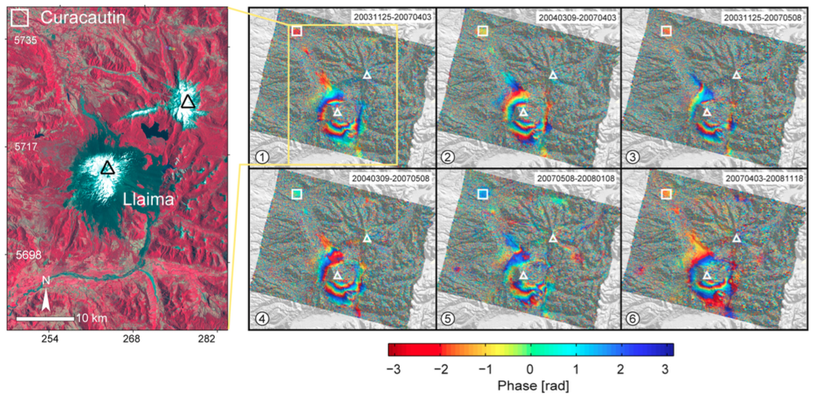 |
(left) Landsat TM image from 1987?01?15 at Llaima volcano in false color where the red, green and blue channels are the bands 4, 3 and 2, respectively. Red color in the image indicates vegetation, white color shows snow and dark grey colors indicate exposed rocky surfaces, here mainly historical lahars and pyroclastic flow deposits. (right) Selected interferograms at Llaima volcano. High coherence is shown only in those areas where no snow or vegetation is seen. Curacautin city (white rectangle) is at approximately 30 km distance from the Llaima summit. White triangles depict the summit craters of the active Llaima and the dormant Sierra Nevada stratovolcanoes. From: Bathke et al. 2011b. |
||
Model Solutions
| Model Solution Type | Min Depth | Max Depth | Min Volume Change | Max Volume Change | Remarks | Citation |
| Point | 4 | 9 | Bathke et al. 2011b |
Reference List: Bathke et al. 2011b.
Full References:
Bathke H, Shirzaei M, Walter T R, 2011. Inflation and deflation at the steep-sided Llaima stratovolcano (Chile) detected by using InSAR. Geophysical Research Letters, 38, L10304. https://doi.org/10.1029/2011GL047168
| Start Date: 2007 | Stop Date: 2008 | Direction: Subsidence | Method: InSAR |
| Magnitude: 11.000 cm | Spatial Extent: Unknown | Latitude: Unknown | Longitude: Unknown |
Remarks: Subsidence is due to a landslide on the eastern flank of Llaima volcano | |||
 |
Multiple interferograms show subsidence along the east flank related to activity in late 2007 and early 2008 (circled region). From: Fournier et al. 2010. |
||
Reference List: Fournier et al. 2010.
Full References:
Fournier, T. J., M. E. Pritchard, and S. N. Riddick, 2010. Duration, magnitude, and frequency of subaerial volcano deformation events: New results from Latin America using InSAR and a global synthesis. Geochemistry Geophysics Geosystems, 11: Q01003. https://doi.org/10.1029/2009GC002558
| Start Date: 2003 | Stop Date: 2007 | Direction: Subsidence | Method: InSAR |
| Magnitude: 10.000 cm | Spatial Extent: 15.00 km | Latitude: -39.000 | Longitude: -72.000 |
|
(left) Landsat TM image from 1987?01?15 at Llaima volcano in false color where the red, green and blue channels are the bands 4, 3 and 2, respectively. Red color in the image indicates vegetation, white color shows snow and dark grey colors indicate exposed rocky surfaces, here mainly historical lahars and pyroclastic flow deposits. (right) Selected interferograms at Llaima volcano. High coherence is shown only in those areas where no snow or vegetation is seen. Curacautin city (white rectangle) is at approximately 30 km distance from the Llaima summit. White triangles depict the summit craters of the active Llaima and the dormant Sierra Nevada stratovolcanoes. From: Bathke et al. 2011b. |
||
Model Solutions
| Model Solution Type | Min Depth | Max Depth | Min Volume Change | Max Volume Change | Remarks | Citation |
| Point | 6 | 12 | Bathke et al. 2011b |
Reference List: Bathke et al. 2011b.
Full References:
Bathke H, Shirzaei M, Walter T R, 2011. Inflation and deflation at the steep-sided Llaima stratovolcano (Chile) detected by using InSAR. Geophysical Research Letters, 38, L10304. https://doi.org/10.1029/2011GL047168
There is data available for 2 emission periods. Expand each entry for additional details.
| Start Date: 2009 Apr 03 | Stop Date: 2009 Apr 03 | Method: Satellite (Aura OMI) |
| SO2 Altitude Min: 4 km | SO2 Altitude Max: 4 km | Total SO2 Mass: 10 kt |
Data Details
| Date Start | Date End | Assumed SO2 Altitude | SO2 Algorithm | SO2 Mass |
| 20090403 | 4.0 | 10.000 |
| Start Date: 2008 Jan 01 | Stop Date: 2008 Jan 01 | Method: Satellite (Aura OMI) |
| SO2 Altitude Min: 13 km | SO2 Altitude Max: 13 km | Total SO2 Mass: 30 kt |
Data Details
| Date Start | Date End | Assumed SO2 Altitude | SO2 Algorithm | SO2 Mass |
| 20080101 | 13.0 | 30.000 |
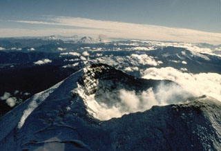 The summit crater of Llaima volcano appears in the foreground of this 1989 view looking north along the chain of Andean volcanoes. An ash plume rises in the middle distance from a flank vent of Lonquimay volcano. To its left is Tolguaca volcano, and Callaqui volcano lies farther to the north to the left of Lonquimay. All these volcanoes except for Tolguaca have erupted in historical time; Llaima is one of Chile's most active volcanoes.
 Llaima, one of Chile's largest and most active volcanoes, has a symmetrical profile when seen from the north. The massive, 3125-m-high, glacier-covered stratovolcano is constructed primarily of accumulated lava flows and has a volume of 400 cu km. Volcán Llaima contains two historically active craters, one at the summit and the other to the SE. More than 40 scoria cones dot the volcano's flanks. Frequent moderate explosive eruptions, a few of which were accompanied by lava flows, have been recorded since the 17th century.
  The light-colored layer at the bottom of the photo is a plinian pumice-fall deposit from Llaima volcano that has been radiocarbon dated at about 8800 year ago. The deposit is 4-m thick at this location, on the Río Trufultruful, 12 km SE of the summit. The dacitic pumice is the most silicic eruptive product known from Llaima and marks the largest known eruption of the volcano during the Holocene. The darker, laminated layers above the pumice deposit are 6-8 m thick pyroclastic-surge deposits from the same eruption.
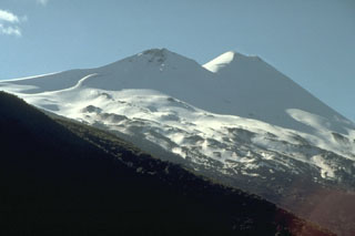 Seen from the SE, Llaima volcano has a twin-peaked profile. Historical eruptions have occurred from craters topping both the 3125-m-high summit cone of Llaima (right) and the 2920-m-high SE cone (left). About 50 eruptions have occurred from Volcan Llaima, one of Chile's most active volcanoes, since its first historical eruption in 1640. Frequent moderate explosive eruptions are often accompanied by lava flows. Mudflows sweeping down the flanks of the glaciated volcano have damaged villages at its foot.
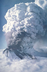 An eruption plume towers above Llaima volcano on May 17, 1994 in this aerial view from the west. Lava fountains are visible along a 550-m-long fissure on the upper SSW flank that fed a subglacial lava flow. Explosive plumes May 17-19 produced ashfall primarily to the ESE. Lahars and flooding associated with the eruption cut roads and destroyed five bridges along the Calbuco River. A dark-gray plume was observed on June 14 or 15, and a new eruptive episode August 25-30 produced ashfall primarily to the SE and north.
 The maps shown below have been scanned from the GVP map archives and include the volcano on this page. Clicking on the small images will load the full 300 dpi map. Very small-scale maps (such as world maps) are not included. The maps database originated over 30 years ago, but was only recently updated and connected to our main database. We welcome users to tell us if they see incorrect information or other problems with the maps; please use the Contact GVP link at the bottom of the page to send us email.
The following 7 samples associated with this volcano can be found in the Smithsonian's NMNH Department of Mineral Sciences collections, and may be availble for research (contact the Rock and Ore Collections Manager). Catalog number links will open a window with more information.
| Catalog Number | Sample Description | Lava Source | Collection Date |
|---|---|---|---|
| NMNH 117275-5 | Lava | -- | -- |
| NMNH 117275-6 | Lava | -- | -- |
| NMNH 117275-7 | Ignimbrite | -- | -- |
| NMNH 117275-8 | Lava | -- | -- |
| NMNH 117982-00 | Laumontite | -- | -- |
| NMNH 118117-1 | plate Tephra | -- | -- |
| NMNH 118117-2 | Airfall Tephra | -- | -- |
| Copernicus Browser | The Copernicus Browser replaced the Sentinel Hub Playground browser in 2023, to provide access to Earth observation archives from the Copernicus Data Space Ecosystem, the main distribution platform for data from the EU Copernicus missions. |
| MIROVA | Middle InfraRed Observation of Volcanic Activity (MIROVA) is a near real time volcanic hot-spot detection system based on the analysis of MODIS (Moderate Resolution Imaging Spectroradiometer) data. In particular, MIROVA uses the Middle InfraRed Radiation (MIR), measured over target volcanoes, in order to detect, locate and measure the heat radiation sourced from volcanic activity. |
| MODVOLC Thermal Alerts | Using infrared satellite Moderate Resolution Imaging Spectroradiometer (MODIS) data, scientists at the Hawai'i Institute of Geophysics and Planetology, University of Hawai'i, developed an automated system called MODVOLC to map thermal hot-spots in near real time. For each MODIS image, the algorithm automatically scans each 1 km pixel within it to check for high-temperature hot-spots. When one is found the date, time, location, and intensity are recorded. MODIS looks at every square km of the Earth every 48 hours, once during the day and once during the night, and the presence of two MODIS sensors in space allows at least four hot-spot observations every two days. Each day updated global maps are compiled to display the locations of all hot spots detected in the previous 24 hours. There is a drop-down list with volcano names which allow users to 'zoom-in' and examine the distribution of hot-spots at a variety of spatial scales. |
|
WOVOdat
Single Volcano View Temporal Evolution of Unrest Side by Side Volcanoes |
WOVOdat is a database of volcanic unrest; instrumentally and visually recorded changes in seismicity, ground deformation, gas emission, and other parameters from their normal baselines. It is sponsored by the World Organization of Volcano Observatories (WOVO) and presently hosted at the Earth Observatory of Singapore.
GVMID Data on Volcano Monitoring Infrastructure The Global Volcano Monitoring Infrastructure Database GVMID, is aimed at documenting and improving capabilities of volcano monitoring from the ground and space. GVMID should provide a snapshot and baseline view of the techniques and instrumentation that are in place at various volcanoes, which can be use by volcano observatories as reference to setup new monitoring system or improving networks at a specific volcano. These data will allow identification of what monitoring gaps exist, which can be then targeted by remote sensing infrastructure and future instrument deployments. |
| Volcanic Hazard Maps | The IAVCEI Commission on Volcanic Hazards and Risk has a Volcanic Hazard Maps database designed to serve as a resource for hazard mappers (or other interested parties) to explore how common issues in hazard map development have been addressed at different volcanoes, in different countries, for different hazards, and for different intended audiences. In addition to the comprehensive, searchable Volcanic Hazard Maps Database, this website contains information about diversity of volcanic hazard maps, illustrated using examples from the database. This site is for educational purposes related to volcanic hazard maps. Hazard maps found on this website should not be used for emergency purposes. For the most recent, official hazard map for a particular volcano, please seek out the proper institutional authorities on the matter. |
| IRIS seismic stations/networks | Incorporated Research Institutions for Seismology (IRIS) Data Services map showing the location of seismic stations from all available networks (permanent or temporary) within a radius of 0.18° (about 20 km at mid-latitudes) from the given location of Llaima. Users can customize a variety of filters and options in the left panel. Note that if there are no stations are known the map will default to show the entire world with a "No data matched request" error notice. |
| UNAVCO GPS/GNSS stations | Geodetic Data Services map from UNAVCO showing the location of GPS/GNSS stations from all available networks (permanent or temporary) within a radius of 20 km from the given location of Llaima. Users can customize the data search based on station or network names, location, and time window. Requires Adobe Flash Player. |
| DECADE Data | The DECADE portal, still in the developmental stage, serves as an example of the proposed interoperability between The Smithsonian Institution's Global Volcanism Program, the Mapping Gas Emissions (MaGa) Database, and the EarthChem Geochemical Portal. The Deep Earth Carbon Degassing (DECADE) initiative seeks to use new and established technologies to determine accurate global fluxes of volcanic CO2 to the atmosphere, but installing CO2 monitoring networks on 20 of the world's 150 most actively degassing volcanoes. The group uses related laboratory-based studies (direct gas sampling and analysis, melt inclusions) to provide new data for direct degassing of deep earth carbon to the atmosphere. |
| Large Eruptions of Llaima | Information about large Quaternary eruptions (VEI >= 4) is cataloged in the Large Magnitude Explosive Volcanic Eruptions (LaMEVE) database of the Volcano Global Risk Identification and Analysis Project (VOGRIPA). |
| EarthChem | EarthChem develops and maintains databases, software, and services that support the preservation, discovery, access and analysis of geochemical data, and facilitate their integration with the broad array of other available earth science parameters. EarthChem is operated by a joint team of disciplinary scientists, data scientists, data managers and information technology developers who are part of the NSF-funded data facility Integrated Earth Data Applications (IEDA). IEDA is a collaborative effort of EarthChem and the Marine Geoscience Data System (MGDS). |

