
Seismicity re-intensifies slightly
The earthquake swarm . . . intensified slightly in January. As of 22 January, 15 local earthquakes had been registered during the month, four of which were felt on 18 January. Records from the seismographs installed in October confirmed that these events originated at depths of 3-5 km directly beneath and slightly W of the crater. The slightly shallower focal depths compared with the earlier events may reflect better depth control. Keith Rowley inspected the crater on 19 January. There were no significant changes. An additional seismograph station was established at Mt. Pleasant, 3 km N of the crater, on 20 January.
Information Contacts: J. Shepherd, K. Rowley, and L. Lynch, UWI.
The Global Volcanism Program has no Weekly Reports available for Liamuiga.
Reports are organized chronologically and indexed below by Month/Year (Publication Volume:Number), and include a one-line summary. Click on the index link or scroll down to read the reports.
Earthquake swarm
An earthquake swarm in the vicinity of Mt. Liamuiga began on 24 October and had declined by early November.
"The volcano is monitored by a single short-period seismograph station 8 km SE of the crater (SKI, figure 1). A second station (NEV) is 35 km to the SE and there are four other stations within 80 km of the volcano. The stations have been operating since 1952/53 and since 1980 have been linked by radio telemetry to the Seismic Research Unit, 700 km to the S. Data transmission is by standard analog techniques but data are recorded digitally using IBM PC-AT microcomputers. Since SKI was installed in 1953 it has recorded occasional microearthquakes with S-P intervals <2 seconds. These earthquakes show impulsive arrivals and clear P and S phases. They may possibly be small tectonic earthquakes but it is more likely that they are A-type volcanic earthquakes associated with Mt. Liamuiga. Normally, one or two are recorded each month.
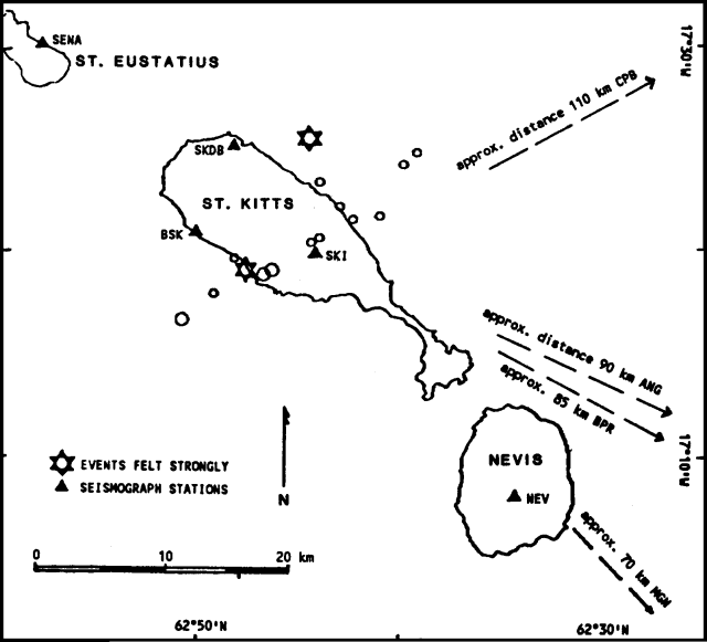 |
Figure 1. Epicenters of the two largest earthquakes (6-pointed stars) and 10 smaller events (open circles) at Liamuiga, 24 October-3 November 1988. Location uncertainties are ~5 km. Seismic stations are shown by solid triangles. Stations off the map are indicated by arrows, labeled with approximate distances from Mt. Liamuiga. Courtesy of UWI. |
"On 24 October, a swarm of these events began and built up rapidly, peaking on 26 October when 186 earthquakes were recorded (figure 2). Many of the earthquakes were felt on St. Kitts and they caused great alarm. John Shepherd carried out an intensity survey on the morning of 27 October. At least five earthquakes were felt by all on St. Kitts. The most severe earthquakes up to that time were at 1201 and 1824 GMT on 26 October, with estimated magnitudes (mb) of 4.3 and 4.5. Both were felt throughout St. Kitts at up to MM VI and caused minor damage to weak masonry. They were also felt on the neighbouring islands of Nevis, Saba, Antigua, and Saint Maarten. Other earthquakes have been reported felt, mainly in the settlements on the flanks of Mt. Liamuiga. A party of tourists was visiting the crater of Mt. Liamuiga at the time of the second large earthquake. They reported that it was difficult to stand and that numerous small landslides were generated on the inner and outer walls of the crater.
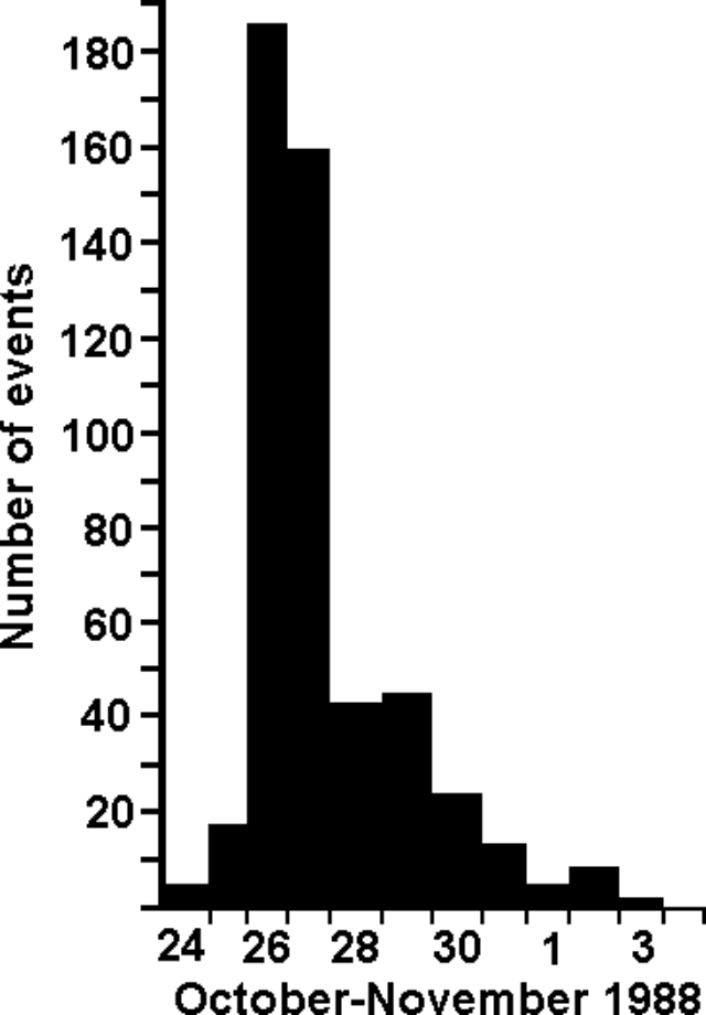 |
Figure 2. Daily numbers of earthquakes near Mt. Liamuiga (S-P intervals <3 seconds) recorded by station SKI beginning 24 October 1988. Courtesy of UWI. |
"Figure 1 shows epicenters of the two biggest earthquakes and 10 others that were sufficiently well recorded for estimates to be made. Focal depths of all events were in the 10-20 km range (mean 15 km). Clearly, the number and distribution of the stations in operation when the earthquakes began were not ideal for the location of the smaller events, so these epicenters are subject to uncertainties of the order of 5 km. To reduce these uncertainties, Lloyd Lynch added three extra stations to the network (BSK, SKDB, and SENA) on 29-30 October. Data from these stations are now being analyzed.
"It is too early to say whether this earthquake swarm has any direct connection with Mt. Liamuiga. It is still possible that they are of tectonic origin. However, the characteristics of the swarm are similar to those of previous volcanic earthquake swarms in other islands of the Lesser Antilles. Many of these swarms have occurred, particularly in the islands of Nevis, Montserrat, Dominica, Guadeloupe, and St. Vincent. Only a small proportion of these swarms have culminated in volcanic eruptions, but on the other hand, almost all eruptions have been preceded by earthquake swarms. This is the first known swarm in St. Kitts and the situation will be carefully monitored."
Information Contacts: J. Shepherd, L. Lynch, and K. Rowley, UWI.
Seismicity remains above background
. . . seismicity remained above background levels in early December, with ~3-4 shallow events recorded weekly by the temporary seismic net installed after the swarm began. Hypocenters were at ~5-10 km depth, almost directly below or slightly W of Mt. Liamuiga, and magnitudes were generally in the 1.5-2 range. The shocks continued to have impulsive P and S wave arrivals typical of both A-type volcanic events and tectonic earthquakes. No tremor has been recorded. Persons familiar with the volcano report that hot springs within the crater remain unchanged.
Information Contacts: J. Shepherd, UWI.
Seismicity re-intensifies slightly
The earthquake swarm . . . intensified slightly in January. As of 22 January, 15 local earthquakes had been registered during the month, four of which were felt on 18 January. Records from the seismographs installed in October confirmed that these events originated at depths of 3-5 km directly beneath and slightly W of the crater. The slightly shallower focal depths compared with the earlier events may reflect better depth control. Keith Rowley inspected the crater on 19 January. There were no significant changes. An additional seismograph station was established at Mt. Pleasant, 3 km N of the crater, on 20 January.
Information Contacts: J. Shepherd, K. Rowley, and L. Lynch, UWI.
|
|
||||||||||||||||||||||||||
There is data available for 3 confirmed eruptive periods.
[ 1843 Feb 8 ] Uncertain Eruption
| Episode 1 | Eruption (Explosive / Effusive) | ||||||||||||||||||||||||
|---|---|---|---|---|---|---|---|---|---|---|---|---|---|---|---|---|---|---|---|---|---|---|---|---|
| 1843 Feb 8 - Unknown | Evidence from Unknown | |||||||||||||||||||||||
|
List of 3 Events for Episode 1
|
||||||||||||||||||||||||
[ 1692 ] Uncertain Eruption
| Episode 1 | Eruption (Explosive / Effusive) | ||||||||||||||||||||||||
|---|---|---|---|---|---|---|---|---|---|---|---|---|---|---|---|---|---|---|---|---|---|---|---|---|
| 1692 - Unknown | Evidence from Unknown | |||||||||||||||||||||||
|
List of 3 Events for Episode 1
|
||||||||||||||||||||||||
0160 ± 200 years Confirmed Eruption (Explosive / Effusive) VEI: 4
| Episode 1 | Eruption (Explosive / Effusive) | Tephra unit F | ||||||||||||||||||||||||||||
|---|---|---|---|---|---|---|---|---|---|---|---|---|---|---|---|---|---|---|---|---|---|---|---|---|---|---|---|---|---|
| 0160 ± 200 years - Unknown | Evidence from Isotopic: 14C (uncalibrated) | ||||||||||||||||||||||||||||
|
List of 4 Events for Episode 1 at Tephra unit F
|
|||||||||||||||||||||||||||||
0060 ± 100 years Confirmed Eruption (Explosive / Effusive)
| Episode 1 | Eruption (Explosive / Effusive) | Tephra unit E | ||||||||||||||||||||||||||||
|---|---|---|---|---|---|---|---|---|---|---|---|---|---|---|---|---|---|---|---|---|---|---|---|---|---|---|---|---|---|
| 0060 ± 100 years - Unknown | Evidence from Isotopic: 14C (uncalibrated) | ||||||||||||||||||||||||||||
|
List of 4 Events for Episode 1 at Tephra unit E
|
|||||||||||||||||||||||||||||
2010 BCE ± 150 years Confirmed Eruption (Explosive / Effusive) VEI: 4
| Episode 1 | Eruption (Explosive / Effusive) | Tephra unit D | |||||||||||||||||||||||||||||||||
|---|---|---|---|---|---|---|---|---|---|---|---|---|---|---|---|---|---|---|---|---|---|---|---|---|---|---|---|---|---|---|---|---|---|---|
| 2010 BCE ± 150 years - Unknown | Evidence from Isotopic: 14C (uncalibrated) | |||||||||||||||||||||||||||||||||
|
List of 5 Events for Episode 1 at Tephra unit D
|
||||||||||||||||||||||||||||||||||
This compilation of synonyms and subsidiary features may not be comprehensive. Features are organized into four major categories: Cones, Craters, Domes, and Thermal Features. Synonyms of features appear indented below the primary name. In some cases additional feature type, elevation, or location details are provided.
Cones |
||||
| Feature Name | Feature Type | Elevation | Latitude | Longitude |
| Middle Range | Stratovolcano | |||
Domes |
||||
| Feature Name | Feature Type | Elevation | Latitude | Longitude |
| Brimstone Hill | Dome | 213 m | 17° 21' 0.00" N | 62° 50' 0.00" W |
| Farm Flat | Dome | 655 m | 17° 22' 0.00" N | 62° 50' 0.00" W |
| Misery Peak, Mount | Dome | 1156 m | 17° 22' 0.00" N | 62° 48' 0.00" W |
| Salt Pond Peninsula | Dome | 17° 15' 0.00" N | 62° 38' 0.00" W | |
| Sandy Point Hill | Dome | 610 m | 17° 22' 0.00" N | 62° 50' 0.00" W |
There are no samples for Liamuiga in the Smithsonian's NMNH Department of Mineral Sciences Rock and Ore collection.
| Copernicus Browser | The Copernicus Browser replaced the Sentinel Hub Playground browser in 2023, to provide access to Earth observation archives from the Copernicus Data Space Ecosystem, the main distribution platform for data from the EU Copernicus missions. |
| MIROVA | Middle InfraRed Observation of Volcanic Activity (MIROVA) is a near real time volcanic hot-spot detection system based on the analysis of MODIS (Moderate Resolution Imaging Spectroradiometer) data. In particular, MIROVA uses the Middle InfraRed Radiation (MIR), measured over target volcanoes, in order to detect, locate and measure the heat radiation sourced from volcanic activity. |
| MODVOLC Thermal Alerts | Using infrared satellite Moderate Resolution Imaging Spectroradiometer (MODIS) data, scientists at the Hawai'i Institute of Geophysics and Planetology, University of Hawai'i, developed an automated system called MODVOLC to map thermal hot-spots in near real time. For each MODIS image, the algorithm automatically scans each 1 km pixel within it to check for high-temperature hot-spots. When one is found the date, time, location, and intensity are recorded. MODIS looks at every square km of the Earth every 48 hours, once during the day and once during the night, and the presence of two MODIS sensors in space allows at least four hot-spot observations every two days. Each day updated global maps are compiled to display the locations of all hot spots detected in the previous 24 hours. There is a drop-down list with volcano names which allow users to 'zoom-in' and examine the distribution of hot-spots at a variety of spatial scales. |
|
WOVOdat
Single Volcano View Temporal Evolution of Unrest Side by Side Volcanoes |
WOVOdat is a database of volcanic unrest; instrumentally and visually recorded changes in seismicity, ground deformation, gas emission, and other parameters from their normal baselines. It is sponsored by the World Organization of Volcano Observatories (WOVO) and presently hosted at the Earth Observatory of Singapore.
GVMID Data on Volcano Monitoring Infrastructure The Global Volcano Monitoring Infrastructure Database GVMID, is aimed at documenting and improving capabilities of volcano monitoring from the ground and space. GVMID should provide a snapshot and baseline view of the techniques and instrumentation that are in place at various volcanoes, which can be use by volcano observatories as reference to setup new monitoring system or improving networks at a specific volcano. These data will allow identification of what monitoring gaps exist, which can be then targeted by remote sensing infrastructure and future instrument deployments. |
| Volcanic Hazard Maps | The IAVCEI Commission on Volcanic Hazards and Risk has a Volcanic Hazard Maps database designed to serve as a resource for hazard mappers (or other interested parties) to explore how common issues in hazard map development have been addressed at different volcanoes, in different countries, for different hazards, and for different intended audiences. In addition to the comprehensive, searchable Volcanic Hazard Maps Database, this website contains information about diversity of volcanic hazard maps, illustrated using examples from the database. This site is for educational purposes related to volcanic hazard maps. Hazard maps found on this website should not be used for emergency purposes. For the most recent, official hazard map for a particular volcano, please seek out the proper institutional authorities on the matter. |
| IRIS seismic stations/networks | Incorporated Research Institutions for Seismology (IRIS) Data Services map showing the location of seismic stations from all available networks (permanent or temporary) within a radius of 0.18° (about 20 km at mid-latitudes) from the given location of Liamuiga. Users can customize a variety of filters and options in the left panel. Note that if there are no stations are known the map will default to show the entire world with a "No data matched request" error notice. |
| UNAVCO GPS/GNSS stations | Geodetic Data Services map from UNAVCO showing the location of GPS/GNSS stations from all available networks (permanent or temporary) within a radius of 20 km from the given location of Liamuiga. Users can customize the data search based on station or network names, location, and time window. Requires Adobe Flash Player. |
| DECADE Data | The DECADE portal, still in the developmental stage, serves as an example of the proposed interoperability between The Smithsonian Institution's Global Volcanism Program, the Mapping Gas Emissions (MaGa) Database, and the EarthChem Geochemical Portal. The Deep Earth Carbon Degassing (DECADE) initiative seeks to use new and established technologies to determine accurate global fluxes of volcanic CO2 to the atmosphere, but installing CO2 monitoring networks on 20 of the world's 150 most actively degassing volcanoes. The group uses related laboratory-based studies (direct gas sampling and analysis, melt inclusions) to provide new data for direct degassing of deep earth carbon to the atmosphere. |
| Large Eruptions of Liamuiga | Information about large Quaternary eruptions (VEI >= 4) is cataloged in the Large Magnitude Explosive Volcanic Eruptions (LaMEVE) database of the Volcano Global Risk Identification and Analysis Project (VOGRIPA). |
| EarthChem | EarthChem develops and maintains databases, software, and services that support the preservation, discovery, access and analysis of geochemical data, and facilitate their integration with the broad array of other available earth science parameters. EarthChem is operated by a joint team of disciplinary scientists, data scientists, data managers and information technology developers who are part of the NSF-funded data facility Integrated Earth Data Applications (IEDA). IEDA is a collaborative effort of EarthChem and the Marine Geoscience Data System (MGDS). |


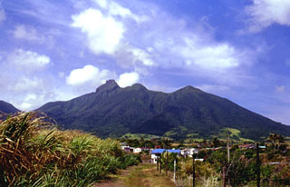 The jagged eastern crater rim of Mount Liamuiga volcano, comprising the NW end of St. Kitts (St. Christopher) Island, conceals a steep-walled, 1-km-wide summit crater. The jagged peak at left center is a lava dome on the eastern crater rim forming the high point of the island. The most recent major eruptions at the volcano less than 2000 years ago produced pyroclastic flows and mudflows whose deposits underlie populated coastal areas. Reports of possible historical eruptions in 1692 and 1843 are considered uncertain.