According to a news report, a swarm of earthquakes occurred beneath Tristan da Cunha during the nights of 28 and 29 July. A scientist monitoring seismic activity from the Preparatory Commission for the Comprehensive Nuclear Test-Ban Treaty Organization, Vienna International Centre indicated that the main swarm lasted ~8 hours and occurred ~30 km below the volcano. After the swarm, there were a few individual earthquakes and then activity tapered off.
Source: Tristan Times
Earthquake swarm on 29-30 July followed by floating pumice
[This event was originally assigned to Tristan da Cunha, but later work located the earthquake swarm on the SE submarine flank of Nightingale Island, about 40 km S.]
The Comprehensive Nuclear Test Ban Treaty Organisation (CTBTO) in Vienna operates a recently installed (July 2002) satellite-linked real-time hydroacoustic station on the island of Tristan da Cunha, with two elements (figure 1). These are designed to record T phases and use three-component short-period seismometers sampled at 100 samples per second. Roderick Stewart, a scientist with the CTBTO, reported that seismic activity, including several felt events, occurred in the vicinity of Tristan da Cunha in July and August 2004. This is the first time that seismicity near this volcano has been instrumentally recorded.
 |
Figure 1. Map of the island of Tristan da Cunha showing the locations of the two CTBTO hydroacoustic stations. Station locations courtesy of R. Stewart, CTBTO. |
An intense swarm of seismic activity was recorded, and felt, on the night of 29-30 July. The activity lasted approximately six hours and peaked around 2100-2200 UTC on 29 July. There were a number of large earthquakes in the swarm; the largest, at approximately 2220 UTC on 29 July, had a body-wave magnitude of 4.2. The epicenter was in the vicinity of the island, but location uncertainties make it impossible to say whether the source was onshore or offshore. Seismic activity continued to be recorded, and occasionally felt, throughout August 2004, but was declining slowly (figure 2). No long-period earthquakes or tremor signals were positively identified although, according to Stewart, the temporal pattern of the swarm appeared to be volcanic. A pseudo-RSAM plot of the data from one of the stations showed that the activity grew gradually to a peak over a period of two or three hours and that the larger events occurred after this peak.
 |
Figure 2. Hourly count of earthquakes at Tristan da Cunha from 27 July to 31 August 2004. Events were counted manually on constant gain plots. The counts of earthquakes during the initial swarm were more than 100 per hour. Courtesy of R. Stewart, CTBTO. |
Stewart described the earthquakes as follows. "All the earthquake signals were impulsive with well-developed P and S phases, typical of volcano-tectonic activity. With only two stations, it is not possible to determine individual hypocentres with any confidence and the locations of the earthquakes can only be inferred from general observations made on the data. First-motion analysis of the P waves was made difficult because the arrivals were very small on the horizontal components. However, it was possible to determine that the P wave was always arriving from the SE at both stations and that the angle of incidence of the arriving P wave was very steep, within 10 degrees of vertical. S-P times were between 4 and 5 seconds at both stations, with H09N1 typically a fraction of a second longer than H09W1. Depending on the velocities assumed, these S-P times indicate that the earthquakes were between 20 and 30 km from the stations. The simplest interpretation of both the above observations is that the earthquakes occurred at depth directly below the volcano. However, an offshore location to the SE cannot be ruled out. What is certain is that these events occurred close to the volcano."
Reports from the island of rocks floating in the water in the days following the seismic activity, along with an initial offshore estimate of the location of the largest earthquake (which had large uncertainties), led to speculation of an underwater eruption. One newspaper account from the Tristan Times on 6 August described "angular and not round" rocks seen by fishermen floating "all around the Island." In a 14 September BBC World Service interview, Island Administrator Mike Hentley stated that fishermen found "huge lumps of [pumice], up to 10 or 12 kg floating on the surface to the south/west of the Island." He further described the pumice as "a very crumbly, light grey stone." Samples of this pumice collected by James Glass (figure 3) are being sent to the Global Volcanism Program.
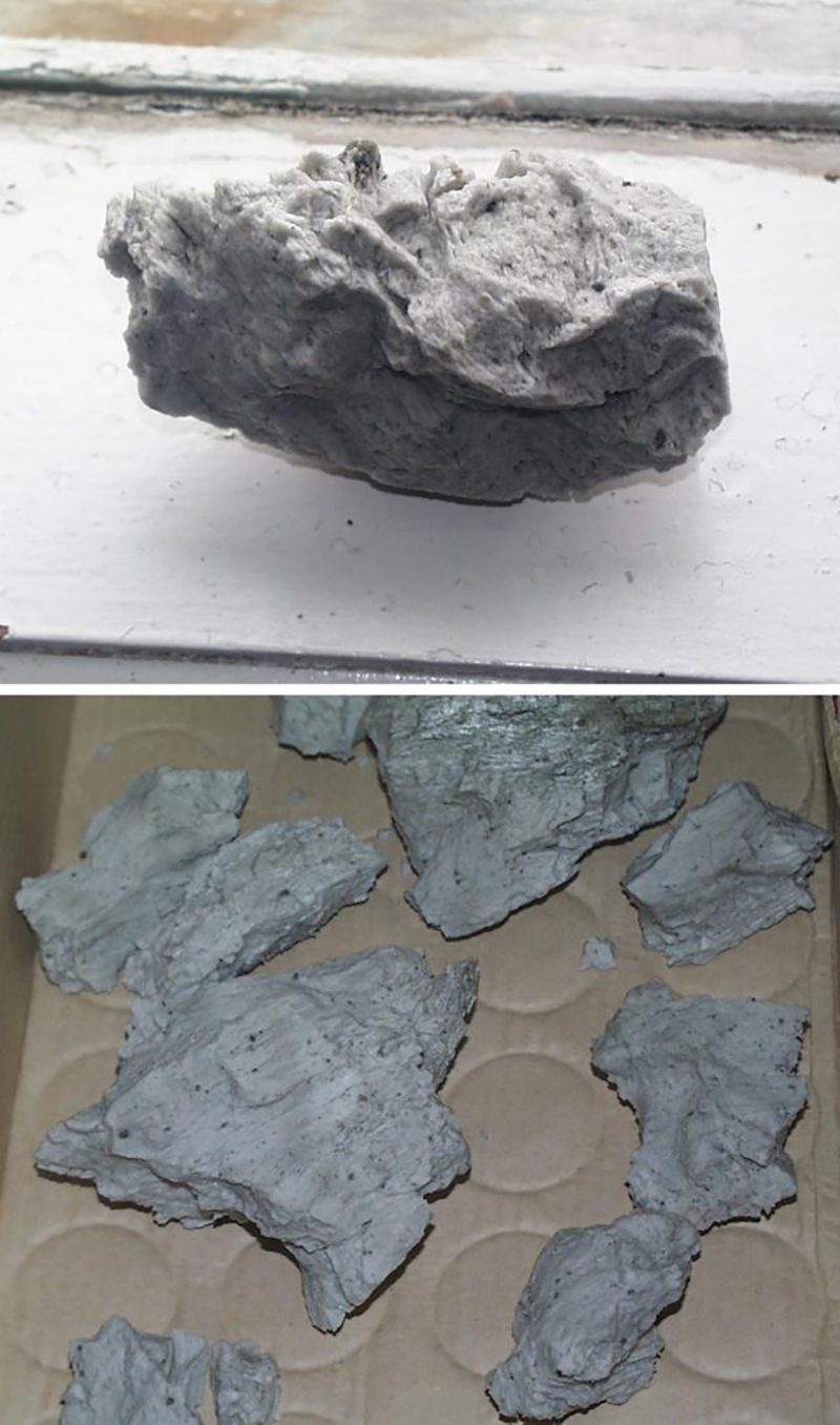 |
Figure 3. Photographs of pumice collected near Tristan da Cunha, August 2004. No scale or size description was provided with the photos, but the top photo of the single sample appears to have been taken on a window ledge and the bottom photo of multiple samples on a bench `seat cushion. Courtesy of James Glass, Tristan Times. |
The Tristan Times also reported on 30 September that volcanologist Victoria Hards from the British Geological Survey (BGS) arrived on the island on 10 September to assess the potential threat of the recent seismic activity. She reportedly determined that the 29-30 July event was caused by rising magma 25 km SE of the island. She also noted that there was no sign of activity at the 1961 eruption site, and no eruption was imminent so there was no threat to the settlement. The BGS planned to monitor the seismic data over the next four months to assess any longer-term implications.
Information Contacts: David Booth, British Geological Survey, Murchison House, Edinburgh EH9 3LA, UK; Roderick Stewart, Preparatory Commission for the Comprehensive Nuclear Test Ban Treaty Organisation (CTBTO), Vienna International Centre, PO Box 1200, A-1400 Vienna, Austria; Juanita Brock and James Glass, Tristan Times (URL: http://www.tristantimes.com); BBC World Service (URL: http://www.bbc.co.uk/worldservice/).
2004: July
According to a news report, a swarm of earthquakes occurred beneath Tristan da Cunha during the nights of 28 and 29 July. A scientist monitoring seismic activity from the Preparatory Commission for the Comprehensive Nuclear Test-Ban Treaty Organization, Vienna International Centre indicated that the main swarm lasted ~8 hours and occurred ~30 km below the volcano. After the swarm, there were a few individual earthquakes and then activity tapered off.
Source: Tristan Times
Reports are organized chronologically and indexed below by Month/Year (Publication Volume:Number), and include a one-line summary. Click on the index link or scroll down to read the reports.
Earthquake swarm on 29-30 July followed by floating pumice
[This event was originally assigned to Tristan da Cunha, but later work located the earthquake swarm on the SE submarine flank of Nightingale Island, about 40 km S.]
The Comprehensive Nuclear Test Ban Treaty Organisation (CTBTO) in Vienna operates a recently installed (July 2002) satellite-linked real-time hydroacoustic station on the island of Tristan da Cunha, with two elements (figure 1). These are designed to record T phases and use three-component short-period seismometers sampled at 100 samples per second. Roderick Stewart, a scientist with the CTBTO, reported that seismic activity, including several felt events, occurred in the vicinity of Tristan da Cunha in July and August 2004. This is the first time that seismicity near this volcano has been instrumentally recorded.
|
Figure 1. Map of the island of Tristan da Cunha showing the locations of the two CTBTO hydroacoustic stations. Station locations courtesy of R. Stewart, CTBTO. |
An intense swarm of seismic activity was recorded, and felt, on the night of 29-30 July. The activity lasted approximately six hours and peaked around 2100-2200 UTC on 29 July. There were a number of large earthquakes in the swarm; the largest, at approximately 2220 UTC on 29 July, had a body-wave magnitude of 4.2. The epicenter was in the vicinity of the island, but location uncertainties make it impossible to say whether the source was onshore or offshore. Seismic activity continued to be recorded, and occasionally felt, throughout August 2004, but was declining slowly (figure 2). No long-period earthquakes or tremor signals were positively identified although, according to Stewart, the temporal pattern of the swarm appeared to be volcanic. A pseudo-RSAM plot of the data from one of the stations showed that the activity grew gradually to a peak over a period of two or three hours and that the larger events occurred after this peak.
|
Figure 2. Hourly count of earthquakes at Tristan da Cunha from 27 July to 31 August 2004. Events were counted manually on constant gain plots. The counts of earthquakes during the initial swarm were more than 100 per hour. Courtesy of R. Stewart, CTBTO. |
Stewart described the earthquakes as follows. "All the earthquake signals were impulsive with well-developed P and S phases, typical of volcano-tectonic activity. With only two stations, it is not possible to determine individual hypocentres with any confidence and the locations of the earthquakes can only be inferred from general observations made on the data. First-motion analysis of the P waves was made difficult because the arrivals were very small on the horizontal components. However, it was possible to determine that the P wave was always arriving from the SE at both stations and that the angle of incidence of the arriving P wave was very steep, within 10 degrees of vertical. S-P times were between 4 and 5 seconds at both stations, with H09N1 typically a fraction of a second longer than H09W1. Depending on the velocities assumed, these S-P times indicate that the earthquakes were between 20 and 30 km from the stations. The simplest interpretation of both the above observations is that the earthquakes occurred at depth directly below the volcano. However, an offshore location to the SE cannot be ruled out. What is certain is that these events occurred close to the volcano."
Reports from the island of rocks floating in the water in the days following the seismic activity, along with an initial offshore estimate of the location of the largest earthquake (which had large uncertainties), led to speculation of an underwater eruption. One newspaper account from the Tristan Times on 6 August described "angular and not round" rocks seen by fishermen floating "all around the Island." In a 14 September BBC World Service interview, Island Administrator Mike Hentley stated that fishermen found "huge lumps of [pumice], up to 10 or 12 kg floating on the surface to the south/west of the Island." He further described the pumice as "a very crumbly, light grey stone." Samples of this pumice collected by James Glass (figure 3) are being sent to the Global Volcanism Program.
|
Figure 3. Photographs of pumice collected near Tristan da Cunha, August 2004. No scale or size description was provided with the photos, but the top photo of the single sample appears to have been taken on a window ledge and the bottom photo of multiple samples on a bench `seat cushion. Courtesy of James Glass, Tristan Times. |
The Tristan Times also reported on 30 September that volcanologist Victoria Hards from the British Geological Survey (BGS) arrived on the island on 10 September to assess the potential threat of the recent seismic activity. She reportedly determined that the 29-30 July event was caused by rising magma 25 km SE of the island. She also noted that there was no sign of activity at the 1961 eruption site, and no eruption was imminent so there was no threat to the settlement. The BGS planned to monitor the seismic data over the next four months to assess any longer-term implications.
Information Contacts: David Booth, British Geological Survey, Murchison House, Edinburgh EH9 3LA, UK; Roderick Stewart, Preparatory Commission for the Comprehensive Nuclear Test Ban Treaty Organisation (CTBTO), Vienna International Centre, PO Box 1200, A-1400 Vienna, Austria; Juanita Brock and James Glass, Tristan Times (URL: http://www.tristantimes.com); BBC World Service (URL: http://www.bbc.co.uk/worldservice/).
The Global Volcanism Program has no synonyms or subfeatures listed for Nightingale Island.
|
|
||||||||||||||||||||||||
There is data available for 1 confirmed Holocene eruptive periods.
2004 Jul 29 - 2004 Jul 30 Confirmed Eruption Max VEI: 0
| Episode 1 | Eruption Episode | Submarine SE flank | ||||||||||||||||||||||||
|---|---|---|---|---|---|---|---|---|---|---|---|---|---|---|---|---|---|---|---|---|---|---|---|---|---|
| 2004 Jul 29 - 2004 Jul 30 | Evidence from Observations: Reported | ||||||||||||||||||||||||
|
List of 3 Events for Episode 1 at Submarine SE flank
| |||||||||||||||||||||||||
There is no Deformation History data available for Nightingale Island.
There is no Emissions History data available for Nightingale Island.
The Global Volcanism Program has no maps available for Nightingale Island.
There are no samples for Nightingale Island in the Smithsonian's NMNH Department of Mineral Sciences Rock and Ore collection.
| Copernicus Browser | The Copernicus Browser replaced the Sentinel Hub Playground browser in 2023, to provide access to Earth observation archives from the Copernicus Data Space Ecosystem, the main distribution platform for data from the EU Copernicus missions. |
| MIROVA | Middle InfraRed Observation of Volcanic Activity (MIROVA) is a near real time volcanic hot-spot detection system based on the analysis of MODIS (Moderate Resolution Imaging Spectroradiometer) data. In particular, MIROVA uses the Middle InfraRed Radiation (MIR), measured over target volcanoes, in order to detect, locate and measure the heat radiation sourced from volcanic activity. |
| MODVOLC Thermal Alerts | Using infrared satellite Moderate Resolution Imaging Spectroradiometer (MODIS) data, scientists at the Hawai'i Institute of Geophysics and Planetology, University of Hawai'i, developed an automated system called MODVOLC to map thermal hot-spots in near real time. For each MODIS image, the algorithm automatically scans each 1 km pixel within it to check for high-temperature hot-spots. When one is found the date, time, location, and intensity are recorded. MODIS looks at every square km of the Earth every 48 hours, once during the day and once during the night, and the presence of two MODIS sensors in space allows at least four hot-spot observations every two days. Each day updated global maps are compiled to display the locations of all hot spots detected in the previous 24 hours. There is a drop-down list with volcano names which allow users to 'zoom-in' and examine the distribution of hot-spots at a variety of spatial scales. |
|
WOVOdat
Single Volcano View Temporal Evolution of Unrest Side by Side Volcanoes |
WOVOdat is a database of volcanic unrest; instrumentally and visually recorded changes in seismicity, ground deformation, gas emission, and other parameters from their normal baselines. It is sponsored by the World Organization of Volcano Observatories (WOVO) and presently hosted at the Earth Observatory of Singapore.
GVMID Data on Volcano Monitoring Infrastructure The Global Volcano Monitoring Infrastructure Database GVMID, is aimed at documenting and improving capabilities of volcano monitoring from the ground and space. GVMID should provide a snapshot and baseline view of the techniques and instrumentation that are in place at various volcanoes, which can be use by volcano observatories as reference to setup new monitoring system or improving networks at a specific volcano. These data will allow identification of what monitoring gaps exist, which can be then targeted by remote sensing infrastructure and future instrument deployments. |
| Volcanic Hazard Maps | The IAVCEI Commission on Volcanic Hazards and Risk has a Volcanic Hazard Maps database designed to serve as a resource for hazard mappers (or other interested parties) to explore how common issues in hazard map development have been addressed at different volcanoes, in different countries, for different hazards, and for different intended audiences. In addition to the comprehensive, searchable Volcanic Hazard Maps Database, this website contains information about diversity of volcanic hazard maps, illustrated using examples from the database. This site is for educational purposes related to volcanic hazard maps. Hazard maps found on this website should not be used for emergency purposes. For the most recent, official hazard map for a particular volcano, please seek out the proper institutional authorities on the matter. |
| IRIS seismic stations/networks | Incorporated Research Institutions for Seismology (IRIS) Data Services map showing the location of seismic stations from all available networks (permanent or temporary) within a radius of 0.18° (about 20 km at mid-latitudes) from the given location of Nightingale Island. Users can customize a variety of filters and options in the left panel. Note that if there are no stations are known the map will default to show the entire world with a "No data matched request" error notice. |
| UNAVCO GPS/GNSS stations | Geodetic Data Services map from UNAVCO showing the location of GPS/GNSS stations from all available networks (permanent or temporary) within a radius of 20 km from the given location of Nightingale Island. Users can customize the data search based on station or network names, location, and time window. Requires Adobe Flash Player. |
| DECADE Data | The DECADE portal, still in the developmental stage, serves as an example of the proposed interoperability between The Smithsonian Institution's Global Volcanism Program, the Mapping Gas Emissions (MaGa) Database, and the EarthChem Geochemical Portal. The Deep Earth Carbon Degassing (DECADE) initiative seeks to use new and established technologies to determine accurate global fluxes of volcanic CO2 to the atmosphere, but installing CO2 monitoring networks on 20 of the world's 150 most actively degassing volcanoes. The group uses related laboratory-based studies (direct gas sampling and analysis, melt inclusions) to provide new data for direct degassing of deep earth carbon to the atmosphere. |
| Large Eruptions of Nightingale Island | Information about large Quaternary eruptions (VEI >= 4) is cataloged in the Large Magnitude Explosive Volcanic Eruptions (LaMEVE) database of the Volcano Global Risk Identification and Analysis Project (VOGRIPA). |
| EarthChem | EarthChem develops and maintains databases, software, and services that support the preservation, discovery, access and analysis of geochemical data, and facilitate their integration with the broad array of other available earth science parameters. EarthChem is operated by a joint team of disciplinary scientists, data scientists, data managers and information technology developers who are part of the NSF-funded data facility Integrated Earth Data Applications (IEDA). IEDA is a collaborative effort of EarthChem and the Marine Geoscience Data System (MGDS). |


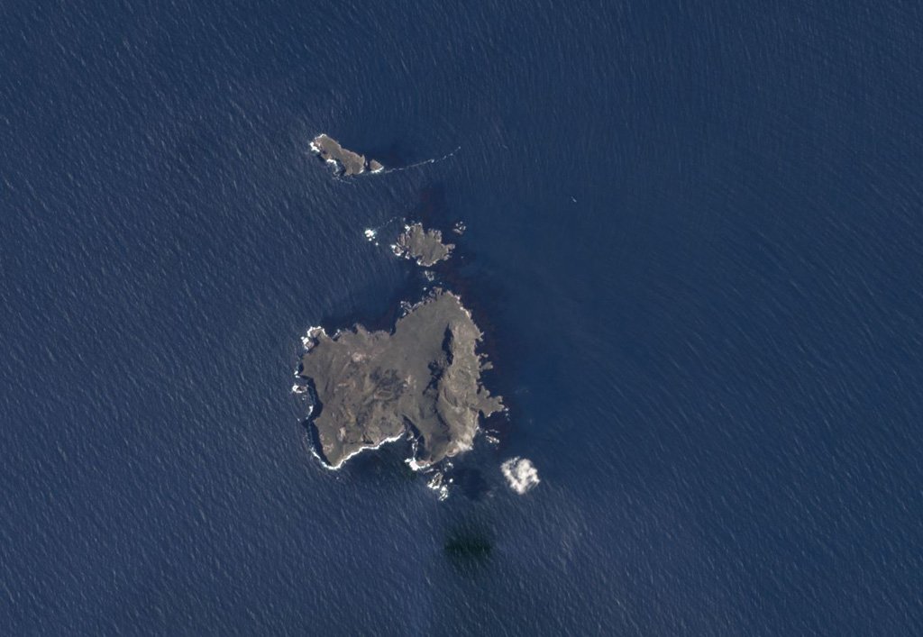
 The roughly 2-km-wide, 3 km2 Nightingale (lower), Middle, and Stoltenhoff (top) islands in the South Atlantic Ocean are shown in this January 2018 Planet Labs satellite image monthly mosaic (N is at the top). The heavily eroded Island is the southernmost of the Tristan da Cunha group, and a submarine eruption occurred in 2004.