Report on Masaya (Nicaragua) — September 1994

Bulletin of the Global Volcanism Network, vol. 19, no. 9 (September 1994)
Managing Editor: Edward Venzke.
Masaya (Nicaragua) Temperatures and SO2 flux from incandescent opening continue rising
Please cite this report as:
Global Volcanism Program, 1994. Report on Masaya (Nicaragua) (Venzke, E., ed.). Bulletin of the Global Volcanism Network, 19:9. Smithsonian Institution. https://doi.org/10.5479/si.GVP.BGVN199409-344100
Masaya
Nicaragua
11.9844°N, 86.1688°W; summit elev. 594 m
All times are local (unless otherwise noted)
A red incandescent area that opened in the inner crater during mid-June 1993 remained active at least through June 1994. An unbroken gas plume has often been observed extending several kilometers from the volcano. Average fumarole temperatures, measured with an infrared pyrometer, began increasing in May 1993 from around 50°C to almost 250°C by July 1993 (figure 9 and 18:07). Fumarole temperatures slowly increased to almost 400°C by May 1994, when they suddenly increased again, reaching almost 600°C by the end of July 1994. Measurement of SO2 emissions at the summit were carried out using colorimetric and chemical techniques. An increase from background to ~5 mg/m3 was detected in June 1993 after the incandescent opening first appeared. SO2 increased to ~15 mg/m3 between July and August, and again increased sharply during September-November 1993 to ~30 mg/m3. Steady increases in the SO2 emission rate since then resulted in measurements of ~35 mg/m3 in May-July 1994.
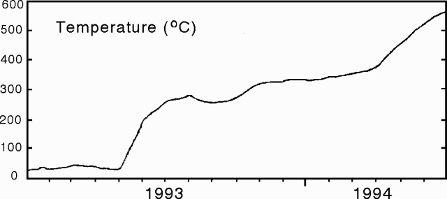 |
Figure 9. Average fumarole temperatures in the summit crater of Masaya, January 1993-July 1994. Courtesy of INETER. |
Geological Summary. Masaya volcano in Nicaragua has erupted frequently since the time of the Spanish Conquistadors, when an active lava lake prompted attempts to extract the volcano's molten "gold" until it was found to be basalt rock upon cooling. It lies within the massive Pleistocene Las Sierras caldera and is itself a broad, 6 x 11 km basaltic caldera with steep-sided walls up to 300 m high. The caldera is filled on its NW end by more than a dozen vents that erupted along a circular, 4-km-diameter fracture system. The Nindirí and Masaya cones, the source of observed eruptions, were constructed at the southern end of the fracture system and contain multiple summit craters, including the currently active Santiago crater. A major basaltic Plinian tephra erupted from Masaya about 6,500 years ago. Recent lava flows cover much of the caldera floor and there is a lake at the far eastern end. A lava flow from the 1670 eruption overtopped the north caldera rim. Periods of long-term vigorous gas emission at roughly quarter-century intervals have caused health hazards and crop damage.
Information Contacts: H. Taleno, L. Urbina, C. Lugo, and O. Canales, INETER.