Report on Telica (Nicaragua) — March 2000

Bulletin of the Global Volcanism Network, vol. 25, no. 3 (March 2000)
Managing Editor: Richard Wunderman.
Telica (Nicaragua) Eruptive activity declines in February, but seismicity remains high
Please cite this report as:
Global Volcanism Program, 2000. Report on Telica (Nicaragua) (Wunderman, R., ed.). Bulletin of the Global Volcanism Network, 25:3. Smithsonian Institution. https://doi.org/10.5479/si.GVP.BGVN200003-344040
Telica
Nicaragua
12.606°N, 86.84°W; summit elev. 1036 m
All times are local (unless otherwise noted)
Seismic and eruptive activity consisting of gas-and-ash explosions continued during January. Observations from the León-Chinandega highway during fieldwork on 13 January showed that constant strong ash-and-gas emissions were continuing (figures 12 and 13). A resident on the S flank informed the scientists that strong rumblings had been heard at dawn on the 12th. The observers remained near the summit for several hours and witnessed moderate explosions every five minutes, with occasional periods of more frequent explosions (3/minute). The bottom of the crater could not be seen through the ash, but it appeared that the explosions did not come from the intercrater that formed in May 1999, but from a new vent in the NNW part of the crater. Evidence of collapses were present along all sides of the crater. In January the number of volcanic earthquakes was 3,950, and the RSAM (real-time seismic amplitude measurement) signal oscillated between the 40 and 120 units.
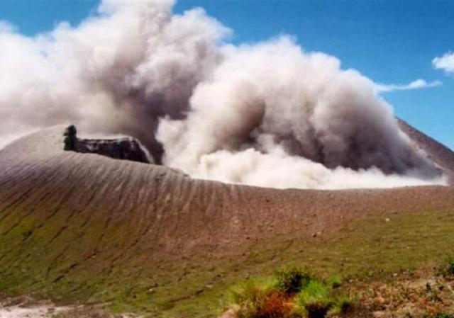 |
Figure 12. Photograph of the active crater during an ash explosion at Telica, 13 January 2000. View is from the south. Courtesy of INETER. |
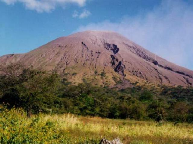 |
Figure 13. Photograph of Telica, 13 January 2000. View is from the north. Courtesy of INETER. |
Low-intensity eruptive activity with ash-and-gas emanations continued through 17 February, after which the activity began to gradually decline. However, seismicity stayed high with 3,670 earthquakes detected in February. The volcano maintained constant tremor during March, but despite the continued high number of registered earthquakes (2,892) there were no gas or ash expulsions.
Geological Summary. Telica, one of Nicaragua's most active volcanoes, has erupted frequently since the beginning of the Spanish era. This volcano group consists of several interlocking cones and vents with a general NW alignment. Sixteenth-century eruptions were reported at symmetrical Santa Clara volcano at the SW end of the group. However, its eroded and breached crater has been covered by forests throughout historical time, and these eruptions may have originated from Telica, whose upper slopes in contrast are unvegetated. The steep-sided cone of Telica is truncated by a 700-m-wide double crater; the southern crater, the source of recent eruptions, is 120 m deep. El Liston, immediately E, has several nested craters. The fumaroles and boiling mudpots of Hervideros de San Jacinto, SE of Telica, form a prominent geothermal area frequented by tourists, and geothermal exploration has occurred nearby.
Information Contacts: Wilfried Strauch and Virginia Tenorio, Dirección General de Geofísica, Instituto Nicaragüense de Estudios Territoriales (INETER), Apartado 1761, Managua, Nicaragua (URL: http://www.ineter.gob.ni/).