Report on Kilauea (United States) — October 2000

Bulletin of the Global Volcanism Network, vol. 25, no. 10 (October 2000)
Managing Editor: Richard Wunderman.
Kilauea (United States) Continued lava production during late-July to mid-November; two hikers dead
Please cite this report as:
Global Volcanism Program, 2000. Report on Kilauea (United States) (Wunderman, R., ed.). Bulletin of the Global Volcanism Network, 25:10. Smithsonian Institution. https://doi.org/10.5479/si.GVP.BGVN200010-332010
Kilauea
United States
19.421°N, 155.287°W; summit elev. 1222 m
All times are local (unless otherwise noted)
The entry of lava into the ocean and the frequent surface flows that occurred from May until mid-July 2000 (BGVN 25:06) continued during late-July to November, the interval discussed in this report. In overview, this interval included several key events. First, during 24-26 August, lava entry along the coast paused. Second, after renewed lava breakout from the tube, the point of lava entry into the sea shifted from the Waha`ula to the Kamokuna area. Third, during 24-25 September, a surge of magma caused a brief period of summit inflation and subsequent deflation. Finally, on 5 November, the bodies of two hikers were found near the sea.
During the end of July lava flowed into the sea mainly at the Waha`ula, Kamokuna, and E coastal entries. Surface flows and inflating pahoehoe flows were abundant, especially on the E edge of the flow field. During 29-31 July a swarm of small (M 2-3), shallow (0-5 km depth) earthquakes occurred just NW of the Hawaiian Volcano Observatory (HVO) in the area of Namakani Paio and the lower Ka`oiki fault system. On 31 July two new vents were observed in the E half of Pu`u `O`o crater, marking the first notable change in the crater in several months. Lava was observed streaming into the sea from atop the narrow bench below the sea cliff in the form of a "fire hose," with the lava stream entering the water ~10 m from the base of the 12- to 15-m-tall cliff (figure 149).
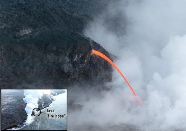 |
Figure 149. Photograph of lava entering the sea in the form of a "fire hose" taken at 0913 on 31 July 2000. The inset shows the location of the lava "fire hose." The view is SE across the coastal plain of the volcano. In the inset he active ocean entries are marked by steam plumes, including Waha'ula the most vigorous entry at the lower left. Courtesy of USGS Hawaiian Volcano Observatory. |
Volcanic activity during most of August was similar to activity in July, i.e. lava flowing into the ocean and several surface flows. Seismicity on the lower SW rift zone, which had begun with a swarm of earthquakes on 19-20 July, increased again during 1-3 August. The swarm consisted of small earthquakes at moderate depths (typically 10-20 km), accompanied by occasional bursts of deep tremor. On 12 August the volcanic tremor near Pu`u `O`o, which had been weak-to-moderate in early August, increased slightly, but returned to weak-to-moderate amplitude the next day. By mid-August the most active coastal entry site was Waha`ula, with little observable activity at the other recently active entry areas.
Pause in activity 24-26 August. A significant change in activity took place on the morning of 21 August when the flow of lava at the Waha'ula entry waned and then stopped. By 24 August all coastal activity, surface flows, and pahoehoe inflation ceased as well. This was the first pause in the delivery of lava to the surface since 11-14 November 1999. During the pause, Kīlauea's summit inflated slightly more than 4 µrad on 26 August as measured by two tiltmeters, one located across Crater Rim Drive from HVO and the other just N of Kīlauea Iki. At Pu`u `O`o cone, a tiltmeter measured an inflation of 3.5 µrad, which started ~5 hours after Kīlauea's summit began to rise. The Pu`u `O`o tiltmeter continued to detect inflation after the rate of summit tilting had drastically declined.
The pause in activity ended sometime on 26 August. Based upon tiltmeter measurements, the pause ended at 2145 that day. By then, tilting associated with inflation at Kīlauea's summit and Pu`u `O`o cone had stopped and may have reversed. Presumably at this time lava broke through to the surface, removing pressure on the plumbing system. In the past an increase in summit tilt has generally accompanied the onset of a pause, but in this case field observations suggested that the pause started about two days before the tilt began to change. Thus, HVO staff concluded that the observational pause lasted about 3 days, while the pause measured by the tiltmeters lasted ~20 hours. After the pause ended (27 August), lava extruded at ~700 m elevation (2,300-ft-elevation). This was the same spot below Pu`u `O`o where lava extruded prior to the pause.
During September lava flowed down Pulama pali and E across the coastal flat. During the afternoon of 23 September, lava reached the ocean for the first time since the August pause. It entered the ocean at the Kamokuna entry, located ~1.5 km WSW of Waha`ula, the previous main area of entry. Initially lava entered the sea sporadically and in very small amounts, but by the morning of 24 September a steady, small steam plume was being produced.
Surge of magma causes brief period of inflation. On the night of 24 September a surge of magma traveled down Kīlauea's E rift zone from the summit reservoir to Pu`u `O`o cone. At 2100 tiltmeters at the summit began to record steep inflation, and about 20 minutes later the tiltmeter on Pu`u `O`o also showed inflation. After 48 minutes the summit abruptly began to deflate and at about 0200 on 25 September the Pu`u `O`o cone started to deflate, which is probably when the surge reached the eruption site.
There were reports of a bright glow over Pu`u `O`o cone in the early morning hours of 25 September. The main source of the glow was from the large collapse pit in the West Gap of the cone where the lava had ponded. About the same time, fresh breakouts probably occurred from the overloaded tube system. Throughout the surge, lava entry at Kamokuna was unaffected and continued to produce a small steam plume. By 0830 lava escaped from a point at the 700 m elevation. Venting occurred in an area ~1km long and a few small breakouts also occurred along the tube at the top and bottom of the fault scarp (pali). By mid-morning, the activity diminished and, at about 1000, the pond inside the West Gap pit drained and did not refill. By 1300 the breakouts from the ~700-m-elevation point had greatly diminished and by 26 September the eruption returned to normal with the Kamokuna ocean entry persisting as an outlet and with additional scattered breakouts of lava on the costal plain (figure 150).
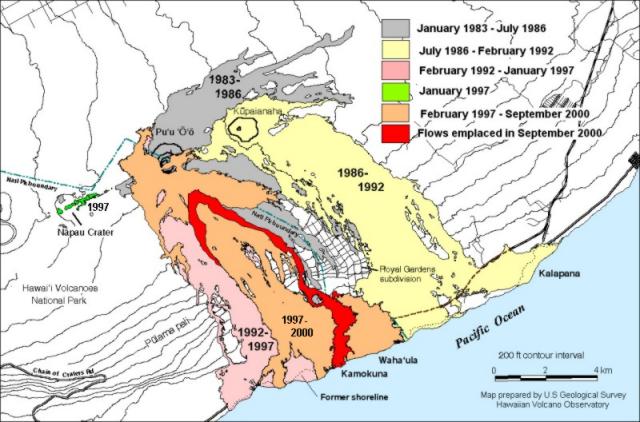 |
Figure 150. Map of Kīlauea showing lava flows (black) active in September 2000 above and on Pulama pali and on the coastal plain, as well as flows erupted earlier from Pu`u `O`o and Kupaianaha. The eastern part of the active flow field (February 1997-September 2000 flows) extended to the Royal Gardens private access road on 11 January 2000 and entered the sea near Waha'ula on 3-14 February. That flow stopped in mid-August. A new flow (black) descended Pulama pali and crossed the coastal plain in September, with lava entering the sea at Kamokuna, an area about 1.5 km WSW of Waha`ula. Courtesy of USGS Hawaiian Volcano Observatory. |
During October there were numerous surface flows and lava continued to enter the sea mainly at the Kamokuna entry. The state of the entry benches changed often, with several collapses accompanied by small littoral explosions. Volcanic tremor gradually increased beginning on 21 October, but returned to a moderate level by 23 October.
Volcanic activity during November was similar to that of the previous months, with lava entering the sea mainly at the Kamokuna entry. No major changes in seismicity occurred at the volcano, but for several hours on the night of 15 November a giant earthquake (M 8.0) in New Ireland, Papua New Guinea caused slow oscillations at Kīlauea's summit amounting to more than 12 µrad (peak-to-peak). Alarms at two tiltmeters were set off by the oscillation's large and comparatively rapid tilts.
At 1408 on 16 November tour pilots reported a large collapse of the bench at Kamokuna. About 30% of the bench disappeared in ~6 seconds as ~1 hectare separated from the rest of the bench along a crack that opened parallel to the shore and then the whole chunk calved off at once. A large explosion followed, with a significant amount of spatter and a big, billowing, mostly white plume that rose an estimated 600-1,800 m into the air. The interior of the bench, exposed by the collapse, was brightly incandescent.
Two deaths on 3 November. At about 1330 on 5 November the bodies of two hikers who died on 3 November were found ~6.4 km W of the end of Chain of Craters road. According to a press release from the National Park Service, the hikers' bodies were located above the sea cliff ~200 m from where lava was entering the ocean. A Park Service press release "ruled out death by [homicidal] violence or trauma" but officials were awaiting autopsy results before concluding the cause of death.
Geological Summary. Kilauea overlaps the E flank of the massive Mauna Loa shield volcano in the island of Hawaii. Eruptions are prominent in Polynesian legends; written documentation since 1820 records frequent summit and flank lava flow eruptions interspersed with periods of long-term lava lake activity at Halemaumau crater in the summit caldera until 1924. The 3 x 5 km caldera was formed in several stages about 1,500 years ago and during the 18th century; eruptions have also originated from the lengthy East and Southwest rift zones, which extend to the ocean in both directions. About 90% of the surface of the basaltic shield volcano is formed of lava flows less than about 1,100 years old; 70% of the surface is younger than 600 years. The long-term eruption from the East rift zone between 1983 and 2018 produced lava flows covering more than 100 km2, destroyed hundreds of houses, and added new coastline.
Information Contacts: Hawaiian Volcano Observatory (HVO), U.S. Geological Survey, PO Box 51, Hawaii National Park, HI 96718, USA (URL: https://volcanoes.usgs.gov/observatories/hvo/).