Report on Anatahan (United States) — July 2005

Bulletin of the Global Volcanism Network, vol. 30, no. 7 (July 2005)
Managing Editor: Edward Venzke.
Anatahan (United States) Continuous activity and extensive ash plumes through July
Please cite this report as:
Global Volcanism Program, 2005. Report on Anatahan (United States) (Venzke, E., ed.). Bulletin of the Global Volcanism Network, 30:7. Smithsonian Institution. https://doi.org/10.5479/si.GVP.BGVN200507-284200
Anatahan
United States
16.35°N, 145.67°E; summit elev. 790 m
All times are local (unless otherwise noted)
Anatahan's third historical eruption began on 5 January 2005 (BGVN 29:12 and 30:02). On 5-6 April 2005, an eruption cloud rose to 15.2 km altitude, the highest yet seen at the volcano (BGVN 30:04). That eruption, estimated to have expelled 50 million cubic meters of ash, caused the temporary closure of Anderson Air Force Base on Guam. An eruption that began on 5 May and produced an extensive ash and steam plume was briefly described in BGVN 30:04, but further details follow. Plumes were frequently visible in satellite imagery; a summary of satellite observations is presented for 16 June-20 July 2005 (table 4).
Table 4. Daily summaries of Anatahan plumes seen in satellite imagery, 16 June-20 July 2005. Satellite abbreviations: DMSP: Defense Meteorological Satellite Program; Feng Yun: "Wind and Cloud"-Peoples Republic of China Earth Observing System meteorological satellite; GOES: Geostationary Operational Environmental Satellites; HIMAWARI: "Sunflower"-Japanese geostationary meteorological satellites; MTSAT: Japanese Meteorological Agency and Japanese Ministry of Transportation satellite; NASA: National Aeronautics and Space Administration; NOAA: National Oceanic and Atmospheric Administration. Courtesy of U.S. Air Force Weather Agency Satellite Applications Branch (Charles Holiday, Jenifer E. Piatt, Mickael A. Archuletta, Brent A. Persinger).
| Date | Times (UTC) and Satellites | Activity Summary |
| 16 Jun 2005 | 0340: NASA Aqua Modis (500 m res.); 0700: GOES-9 Visual | 3-km-high ash/steam moving W-WSW at 19-28 km/hour out to 370 km; 3 km high thin ash/vog out to 1,500 km to W-WNW. |
| 17 Jun 2005 | 0125: NASA Terra Modis (500 m res.); 0448: DMSP F-13 Visual | 3-km-high ash/steam moving W-WSW at 28-37 km/hour out to 185 km; 3 km high thin ash/vog out to 1,500 km to WNW. |
| 18 Jun 2005 | 0030: NASA Terra Modis (1 km res.); 0703: GOES-9 Visual; 1041: DMSP F116 Night Visual | 3-km-high dense ash/steam plume out to 314 km; volcanic haze out to 1,780 km W and 760 km NW. |
| 19 Jun 2005 | 0646: NOAA-12 Visual (0.6 km); 0700: Feng Yun-2 (2.8 km); 0725: GOES-9 Visual; 0819: DMSP F-13 Visual (0.6 km); 0819: DMSP F-13 IR (2.8 km); 1034: DMSP F-16 Night Visual | Brief eruption at 0525Z, ash 15 km high moving E; cloud dissipated by 1400Z after migrating 400 km SE; 3-km-high ash/steam out to 250 km W; 2.4-km-high thin ash/vog out to 1,900 km WNW and 860 km NW. |
| 20 Jun 2005 | 0700: GOES-9 Visual; 1016: DMSP F-13 Night Visual (2.8 km) | 3-km-high eruption cloud moving 28-37 km/hour W; moderately dense ash/steam plume extends 695 km WNW; thin ash/vog out to 1,500 km NW. |
| 21 Jun 2005 | 0100: NASA Terra Modis (250 m res.); 0700: GOES-9 Visual | 3-km-high eruption moving W at 37 km/hour extending 460 km W; 3-km-high ash/vog extending out to 1,570 km W, then shifting N and NE toward Volcano Islands. |
| 22 Jun 2005 | 0305: NASA Aqua Modis (250 m res.); 0700: DMSP F-12 Visual (0.55 km); 0700: GOES-9 Visual | 1.5-km-high eruptions moving W at 28 km/hour; ash/steam extending 280 km until obscured by clouds; thin ash/steam out to 1,940 km W. |
| 23 Jun 2005 | 0030: NASA Terra Modis (500 m res.); 0702: Enhanced GOES 9 Visual; 0826: Enhanced DMSP F-12 Visual | Ash/steam plume out to 740 km; two SW/NE swaths of vog out 1,760 km N, 1,800 km NE, and 1,950 km W. |
| 24 Jun 2005 | 0130: NASA Terra Modis (500 m res.); 0647: DMSP F-12 Visual; 0725: Enhanced GOES-9 Visual | 3.5-km-high dense, continuous ash/steam plume extending over 695 km W; large area of vog extending over 1,760 km W, 1,440 km N, and over 1,430 km E. |
| 25 Jun 2005 | 0215: NASA Terra Modis (500m res.); 0525: NOAA-16 Visual; 0725: Enhanced GOES-9 Visual; 0841: DMSP F-13 Visual | 3.5-km-high ash/steam plume out to 850 km; vog plume 2,000 km W, then 1,700 km N, then 1,940 km E. |
| 27 Jun 2005 | 0025: NASA Terra Modis (500 m res.); 0600: GOES-9 Visual; 0744: NOAA-15 Visual (0.9 km) | 3.7-km-high ash/steam plume 130 km W; 3-km-high thin ash/vog 1,480 km W, then 740 km N. |
| 28 Jun 2005 | 0405: NASA Aqua Modis (500 m res.); 0410: NASA Aqua Modis (2 km res.); 0717: DMSP F-12 Visual (1.8 km) | Moderately thick ash/steam plume 3 km high extends 150 km W moving at 27-37 km/hour; thin ash/vog extends 1,900 km W, then turns N moving over Ryukyu Islands. |
| 29 Jun 2005 | 0450: NASA Aqua Modis; 0700: GOES-9 Visual | 3-km-high moderately thick ash/steam plume reached between 420 and 600 km W moving 37 km/hour; thin ash/vog extends over 1,800 km W, then veers N over Ryukyu Islands. |
| 30 Jun 2005 | 0700: GOES-9 Visual; 0911: DMSP F-13 Visual (1.0 nm); 1425: GOES-9 Split Window IR | 3-km-high ash/steam plume extended 210 km W moving W about 27 km/hour; thin 3-km-high ash/vog extends over 2,400 km W, then veers N, reaching E Taiwan and East China Sea. |
| 01 Jul 2005 | 0135: NASA Terra Modis; 0637: Enhanced DMSP F-12 Visual; 0637: Enhanced HIMAWARI; 0711: Enhanced GOES-9 Visual; 2214: DMSP F-16 Visual | 3-km-high ash/steam plume extending over 740 km W; area of vog extending about 2,300 km NW and over 1,480 km NNE; as vog area moves farther W begins to intermix with smoke from fires in China. |
| 02 Jul 2005 | 0030: NASA Terra Modis; 0345: NASA Aqua Modis; 0638: Enhanced NASA Visual; 1049: Enhanced GOES-9 Split-Window IR | 4.6-km-high dense ash/steam plume extending about 460 km W; area of vog extends farther W to approximately 2,200 km; as the area of vog get closer to China, it becomes intermixed with smoke from the fires in mainland China and begins to move E to a point about 1,800 km N of Anatahan before it is no longer detectable on imagery. |
| 03 Jul 2005 | 0800: Feng Yun-2 Visual; 0823: DMSP F-13 Visual; 1201: GOES-12 Split Window IR | 5.5-km-high fairly dense ash/steam plume extending NW about 190 km; ash erupted earlier today reached initial level of 12.2 km SE of summit; area of ash/vog and haze extending W about 1,000 km. |
| 04 Jul 2005 | 0330: NASA Aqua Modis; 0638: MTSAT Visual; 0716: NOAA-12 Visual; 0800: Feng Yun-2 Visual; 0809: DMSP F-13 Visual | Fairly dense ash/steam plume 4.3-6.1 km high extending W approximately 390 km; area of ash/vog and haze extending to W about 2,200 km out into the Philippine Sea. |
| 05 Jul 2005 | 0110: NASA Terra Modis; 0415: NASA Aqua Modis; 0456: Feng Yun-2 Visual; 0504: NOAA-16 Visual; 0854: DMSP F-14 Visual; 1801: GOES-9 Split Window IR | 7.6-km-high fairly dense ash/steam plume extending W about 570 km; area of ash/vog and haze extending about 2,460 km W and into the Philippine Sea. |
| 06 Jul 2005 | 0320: NASA Aqua Modis; 0706: DMSP F-12 Vis (1.0 nm); 0706: DMSP F-12 Vis (0.3 nm); 0840: DMSP F-14 Vis (0.3 nm) | 4.3-km-high fairly dense ash/steam plume extending W about 1,100 km; 3.0-km-high thin ash/vog area out to about 1,900 km; in 0840Z satellite, eruption plume rises to about 12.2 km. |
| 07 Jul 2005 | 0100: NASA Terra Modis; 0700: GOES-9 Visual | 4.3-km-high ash/steam plume W to 1,060 km; 3-km-high thin ash/vog area W to about 1,940 km, then NNE about 1,200 km. |
| 08 Jul 2005 | 0305: NASA Aqua Modis (500 m res.); 0445: NASA Aqua Modis (2 km res.); 0700: GOES-9 Visual; 0811: DMSP F-14 Visual (0.6 km) | 3.7-km-high ash/steam plume W to 1,160 km; 3-km-high thin ash/vog area W to 2,400 km, with lobes to N. |
| 09 Jul 2005 | 0050: NASA Terra Modis Image; 0350: NASA Aqua Modis; 0638: MTSAT Visual; 0834: DMSP F-13 Visual; 2300: GOES-9 Split-Window | 3-km-high very distinct ash/steam plume extending W about 630 km; large area of vog extending W to over 2,500 km, out to the coast of the Philippines and Taiwan; at 2300 another eruption extending to 9.8 km high and ~70 km S of summit. |
| 10 Jul 2005 | 0130: NASA Terra Modis; 0638: Enhanced MISAT Visual; 0800: Feng Yun-2 Visual; 0825: DMSP F-13 Visual | Very distinct ash/steam plume 5.5-6.1 km high extending ~790 km WSW; large area of vog extending to over 2,600 km W to the coast of Philippines and Taiwan and another area of vog being caught up in the flow ~1,600 km NW of the volcano; between 10 Jul 2005 at 2200Z and 11 Jul 2005 at 1200Z, Kadena AB (RODN) surface reports indicated haze and 6-11 km visibilities. |
| 11 Jul 2005 | 0035: NASA Terra Modis (500 m res.); 0700: GOES-9 Visual; 0810: DMSP F-13 Visual (0.6 km) | Beginning at 0700Z, 7.6-km-high plume measured 46 km NNE, and an ash/steam plume to 6.1 km measured 600 km W; beyond that point, thin ash/VOG, estimated below 4.6 km, extended 1,900 km W and veered N toward the Ryukyu Is; current eruptions (at 1500Z) are to 4.6 km moving W at 19-28 km/hour. |
| 12 Jul 2005 | 0420: NASA Aqua Modis (500 m res.); 0700: GOES-9 Visual; 0757: DMSP F-13 Visual (0.6 km); 2322: DMSP F-15 Visual (0.6 km) | Eruption plumes are to 6.1 km, and light winds moving thick ash/steam out to 90 km W, and thinner ash/steam extended 140 km NE; area of thin ash/vog stretched W to coast of the Philippines, while vog continued to reduce visibilities over the Ryukyu Is.; Kadena AB surface observations indicated haze and 8-10 km visibilities between 0300Z and 1500Z; eruption to 11 km occurred at around 2300Z, and an ash cloud moved at 65-74 km/hour W. |
| 13 Jul 2005 | 0020: NASA Terra Modis (500 m res.); 0056: NOAA-17 Visual (0.9 km); 0700: GOES-9 Visual | At 0020 ash cloud seen about 74 km W; at about 0700 radar estimated another plume to 9.4 km, which remained stationary near the summit; at the same time, ash/steam to 6.1 km extended 185 km; thin ash/vog continued to the Philippines; vog over the Ryukyu Is. |
| 14 Jul 2005 | 0001: DMSP F-13 Visual; 0638: Enhanced MTSAT Visual | Typhoon Haitang, sitting to NNW of Anatahan, caused extensive cloud cover; at ~930 km to W is area of vog that extends to the Philippine coastal region; faint plume extending to the N ~80 km; large area of vog SW of Typhoon Haitang and extending W. |
| 15 Jul 2005 | 0638: Enhanced MTSAT Visual | Extensive cloud cover over Anatahan making detection of any ash/steam very difficult; area of vog located along the E coast of central Philippines area extending E ~960 km. |
| 16 Jul 2005 | 0638: Enhanced MTSAT Visual | Convective activity persistent over the volcano, making ash/steam detection impossible; Super Typhoon Haitang is disrupting any remaining areas of VOG in the W Pacific. |
| 18 Jul 2005 | 2206: DMSP F-16 Visual (0.9 km) | 6.7-km-high ash/steam plume extending 210 km NW. |
| 19 Jul 2005 | 2228: DMSP F-15 Visual (0.6 km) | Due to cloud cover, ash/steam not visible on satellite data since around 0000; current eruptions assumed to be 3-6.7 km high moving N at a maximum speed of 20 km/hour. |
| 20 Jul 2005 | No visible ash in imagery | Due to cloud cover, ash/steam not visible on satellite data since about 0200; eruption plumes are assumed to 3 km high moving NW at 19-28 km/hour; an eruption to 15.5 km was detected by 2215, and ash moved SE at 29-37 km/hour; due to extensive cloud cover over the area, no ash was visible via satellite at any time during the past 12 hours; this is the 12th eruption with ash to 9.1 km and/or above since the beginning of June; as of 1000, ash was no longer visible in radar and eruption plumes were estimated to 9.1 km moving NE at 37-56 km/hour. |
Observations during early May 2005. Activity surged to a moderately high level on 5 May, when an extensive ash-and-steam plume to 4.5 km altitude was visible in all directions. Ash extended 770 km N, 130 km S to northern Saipan, and 110 km W. Vog extended in a broad swath from 3,000 km W, over the Philippine Islands, to 1,000 km N of Anatahan. By 9 May harmonic tremor amplitude had decreased to near background levels, with a corresponding drop in eruptive activity. As of 10 May the Air Force Weather Agency (AFWA) reported ash rising to about 3 km altitude and extending 400 km W, with an area of vog less than half that noted on 5 May.
Anatahan began erupting suddenly from its E crater at about 1700 on 10 May. Within hours of the eruption's onset, a towering column of volcanic ash and gas rose to more than 10 km altitude, and the prevailing wind blew the ash W. An immediate concern was the potential for the tiny abrasive ash fragments to damage aircraft passing nearby and downwind from the volcano. The Washington Volcanic Ash Advisory Center issued an advisory that volcanic ash was present at 11 km altitude moving S at 65 km/hour and at 4.6 km altitude moving W at 20-30 km/hour.
The single seismic station on the island maintained by the Emergency Management Office of the Commonwealth of the Northern Mariana Islands (EMO/CNMI) was not working at the time, but a broadband seismic instrument installed 6.5 km W of Anatahan's crater on 6 May by scientists from Washington University in St. Louis recorded significant earthquake activity in the hours before the eruption began; the instrument was one of many installed to conduct a seismic experiment along the Mariana Trench. A preliminary review of the data shows there was a rapid increase in the number of small-magnitude earthquakes (probably less than M 2) to more than 100 per hour beneath the volcano within a few hours of the eruption onset.
A smaller but nearly continuous eruption column rose from the E crater of Anatahan for several days following 10 May. The resulting eruption clouds were generally below about 6 km altitude. On 11 May AFWA reported thick ash rising to 4.2 km altitude and moving WNW. The ash extended in a triangular shape from the summit 444 km to the WSW through 510 km to the NW. A layer of diffuse ash at 3 km altitude extended beyond the dense ash for another 1,000 km. A broad swath of vog extended over 2,200 km W nearly to the Philippines and over 1,400 km NNW of Anatahan. Although the ash plume diminished over the next few days, it remained significant, rising to 2.4 km altitude and extending 370 km WNW on 13 May. Personnel from EMO/CNMI and the U.S. Geological Survey (USGS) who were repairing and installing equipment on 14 May reported hearing a continuous roaring sound from 2-3 km W of the active vent. They also saw ash and steam rising by pure convection, not explosively, to 3 km altitude.
Observations during later May and June 2005. Following nearly continuous eruption from January through April 2005, on 23-24 May typhoon Chan-hom shifted the prevailing E winds to the S, blowing the eruption column toward Saipan and Guam. Light ashfall resulted in flight cancellations at the Saipan and Guam international airports. Residents of Saipan reported a rotten-egg smell associated with the ashfall. The ongoing explosive activity excavated a deep crater within Anatahan's E crater. Scientists estimated the inner crater was nearly at sea level by about 20 May; before the eruption, the floor of E crater was 68 m above sea level.
The spiny surface of a lava flow was first observed in the inner crater on 4 June. The flow appeared to form a mound-shaped lava dome, but its volume is unknown. New fault scarps and slump features were seen within the E crater, as well as additional faulting W of the E crater. A gradual increase in the number of long-period (LP) earthquakes and tremor began at Anatahan on 5 June. Both LP and tremor events peaked during 2230-0030 on 6 June. During the peak in activity, more than 350 LP events occurred. Tremor amplitudes briefly reached a new high for the current eruptive activity, and an ash column reached ~ 7.9 km altitude. On 6 June, tremor amplitudes returned to low levels. During the rest of the week of 1-7 June, ash plumes reached a maximum altitude of 4.3 km. On 5 June the EMO/CNMI seismic station was repaired and ash samples were collected from the site. Through 12 June, the seismic records showed only continuous ground shaking to varying degrees. The most intense periods of tremor lasted 3 to 10 hours and occurred about every 24-36 hours.
On 12 June, three LP earthquakes were recorded, the largest about M 2. Other earthquakes followed in the late afternoon and early evening of 13 June. During 17-26 June 2005, seismicity was at the highest level since the eruption on 6 April, with real-time seismic amplitude (RSAM) values at ANA2 consistently near 625.
Since 18 May, Anatahan has sent ash and steam continuously to 2.4 km altitude or higher, with seven eruptive pulses to 7.6 km altitude or higher. On 11 June, a 10 minute-long eruptive pulse sent ash and steam to 14 km altitude. On June 19, a 2.6 minute-long eruptive pulse sent a cloud of steam and ash to 15.2 km altitude; the cloud moved E and dissipated after about 7 hours. On 6 July, very high levels of tremor for about 30 minutes accompanied an eruptive pulse to 12.2 km altitude.
On 11 June beginning at 1622 three explosions produced a dense ash cloud that rose to an altitude of ~ 13.7 km. On 12 June, seismicity was at moderately high levels, with periods of strong tremor and frequent small LP earthquakes. Satellite imagery showed an ash cloud at an altitude of ~ 3 km.
Two strong explosions on 14 June removed much of the small new dome in the inner crater. Just before noon on 14 June, earthquakes began to occur at intervals of 1-2 minutes. For the next two days, episodes of intense tremor and earthquakes lasting about 1.5 hours occurred about every 12 hours, accompanying strong ash emissions from the E crater, with eruption columns higher than 2 km altitude. Quiet intervals in which the eruption column contained little ash were accompanied by continuous weak tremor.
On 19 June at 1525 a brief eruption produced a steam-and-ash cloud that reached an altitude of ~ 15.2 km (figure 18). Guam Meteorological Weather Office radar showed that the cloud drifted E. No seismic signal was clearly associated with the eruption. Two days before the eruption, the amplitude of continuous tremor was relatively high. During the days before and after the eruption, ash reached 3-4.6 km and drifted W.
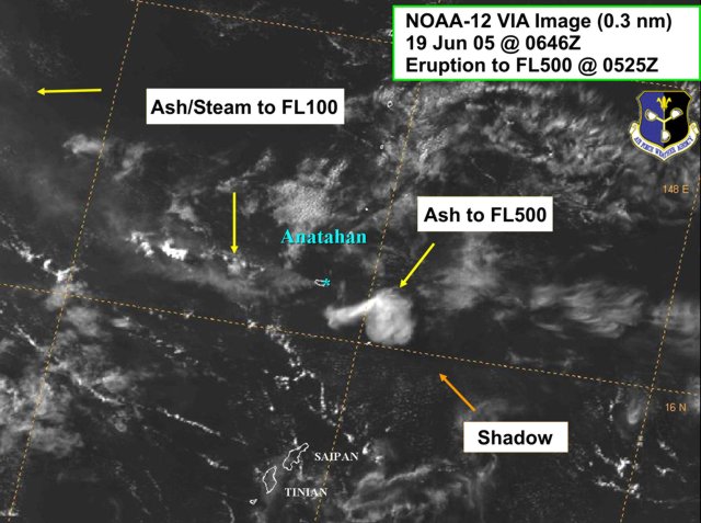 |
Figure 18. NOAA satellite image of the ash plume at FL500 (15.2 km) from the Anahatan eruption of 19 June 2005. This was one of the highest plumes ever recorded from the volcano. Its position SE of Anahatan is unusual; the usual direction of the ash and other emissions is W. Courtesy of US Air Force Weather Agency. |
During 22-27 June AFWA observed, on satellite imagery, a moderately dense cloud of ash and steam that rose to a maximum altitude of ~ 3 km, and drifted W. Additional thin ash and vog were visible to the W and NNW of the island. On 26 June AFWA identified, on satellite imagery, a dense cloud of ash and steam rising to ~ 3.7 km, moving towards the W, and vog to the W, N and NE of the island (figure 19). No particular seismic signal was associated with the eruptions. By 28 June the seismicity level dropped by about 80% from the continuously high levels of the last week.
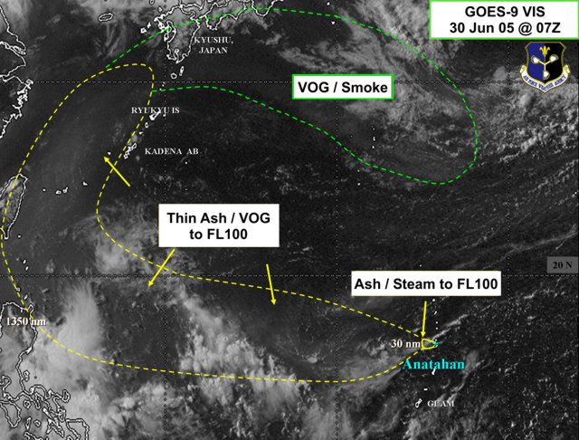 |
Figure 19. GOES-9 image of 30 June 2005 showing the extent of the atmospheric injection of Anahatan ash and gas. The emission reached the island of Kyushu. Courtesy of US Air Force Weather Agency. |
On 3 July at 1646 an eruption produced a SSE-drifting plume to an altitude of ~ 12.2 km, according to Guam Meteorological Office radar. Vog briefly drifted S over the islands of Saipan and Tinian. During 29 June to 5 July, steam-and-ash emissions continued to rise to low altitudes. During 6-11 July, eruptive activity continued, with steam-and-ash plumes rising to a maximum altitude of 6.1 km. On 6 July beginning at 1730 tremor at the volcano increased, and an eruption produced an ash plume to an altitude of ~ 12.2 km. During 8-11 July, a thin layer of vog extended over much of the Philippine Sea (figure 20).
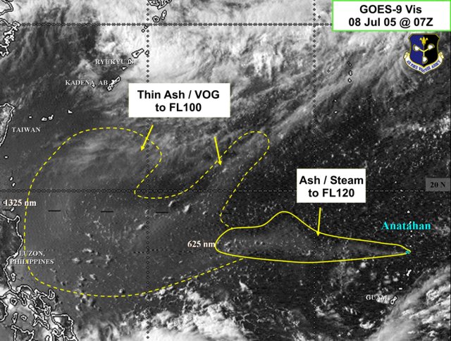 |
Figure 20. GOES-9 image of 8 July 2005 showing the ash plume and vog from Anahatan extending 2,450 km W almost to the Philippines and Taiwan. Courtesy of US Air Force Weather Agency. |
As of 1 August 2005, Anatahan was presumed to be in a state of constant eruption. For the first half of 1 August, volcanic tremor levels as recorded at Anatahan's E seismic station (ANA2) were between 40 and 60 % of the peak levels observed during 17-26 June. At 0800, the National Weather Service at Tiyan, Guam, issued a volcanic ash advisory for Saipan and Tinian. A strong sulfur odor from the emitted volcanic gases was reported by numerous residents, and ash was observed on the tips of aircraft at Saipan International Airport. Traces of ash were also apparent on solar panels powering equipment run by the EMO/CNMI on Saipan. According to the Air Force Weather Agency, continued cloud cover caused by a tropical storm inhibited ash detection on METSAT imagery. As of 1252 on 1 August, the ash plume was presumed to be at an altitude of 4.6 km, moving toward the S at 18-27 km/hour.
Geological Summary. The elongate, 9-km-long island of Anatahan in the central Mariana Islands consists of a large stratovolcano with a 2.3 x 5 km compound summit caldera. The larger western portion of the caldera is 2.3 x 3 km wide, and its western rim forms the island's high point. Ponded lava flows overlain by pyroclastic deposits fill the floor of the western caldera, whose SW side is cut by a fresh-looking smaller crater. The 2-km-wide eastern portion of the caldera contained a steep-walled inner crater whose floor prior to the 2003 eruption was only 68 m above sea level. A submarine cone, named NE Anatahan, rises to within 460 m of the sea surface on the NE flank, and numerous other submarine vents are found on the NE-to-SE flanks. Sparseness of vegetation on the most recent lava flows had indicated that they were of Holocene age, but the first historical eruption did not occur until May 2003, when a large explosive eruption took place forming a new crater inside the eastern caldera.
Information Contacts: Juan Takai Camacho and Ramon Chong, Emergency Management Office of the Commonwealth of the Northern Mariana Islands (EMO/CNMI), PO Box 100007, Saipan, MP 96950, USA (URL: http://www.cnmihsem.gov.mp/); Hawaiian Volcano Observatory (HVO), U.S. Geological Survey, PO Box 51, Hawaii Volcanoes National Park, HI 96718, USA (URL: https://volcanoes.usgs.gov/observatories/hvo/); Charles Holliday and Jenifer E. Piatt, U.S. Air Force Weather Agency (AFWA)/XOGM, Offutt Air Force Base, NE 68113, USA; Randy White and Frank Trusdell, U.S. Geological Survey, 345 Middlefield Road, Menlo Park, CA 94025-3591, USA (URL: https://volcanoes.usgs.gov/nmi/activity/).