Report on Yasur (Vanuatu) — November 2013

Bulletin of the Global Volcanism Network, vol. 38, no. 11 (November 2013)
Managing Editor: Richard Wunderman.
Yasur (Vanuatu) Explosive activity during May, August, and November 2013
Please cite this report as:
Global Volcanism Program, 2013. Report on Yasur (Vanuatu) (Wunderman, R., ed.). Bulletin of the Global Volcanism Network, 38:11. Smithsonian Institution. https://doi.org/10.5479/si.GVP.BGVN201311-257100
Yasur
Vanuatu
19.532°S, 169.447°E; summit elev. 361 m
All times are local (unless otherwise noted)
Our previous report from May 2013 (BGVN 38:05) noted Strombolian activity, including volcanic bombs in July 2012 and ashfall and volcanic bombs in April and May 2013. The Vanuatu Geohazards Observatory (VGO) bulletin from 28 May 2013 noted that Yasur's explosive activity had increased slightly, compared to the recent past. The activity included Strombolian explosions (figure 43) and ash and steam plumes. This report discusses activity from June 2013 through February 2014, along with photographs taken in May 2013. A map of Vanuatu and nearby countries was provided in BGVN 35:06.
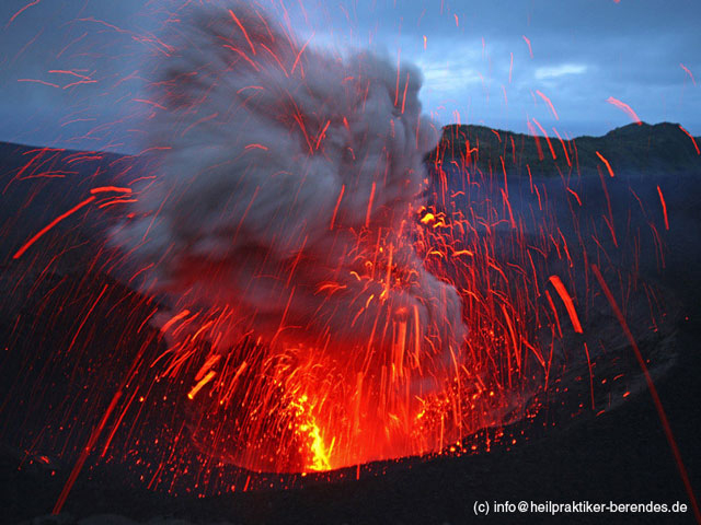 |
Figure 43. Strombolian activity from Yasur recorded during May 2013. Courtesy of Volcano Discovery (Dietmar Berendes). |
Observations and seismic data from early to mid-August 2013 suggested that explosive activity of the volcano had decreased slightly during that time. Explosions were weaker and less frequent. Therefore, on 29 August 2013, the VGO decreased the Alert Level from 2, where it had been since early April 2013, to 1. Level 1 (on a scale of 0-4) indicates "increased activity [but] danger near crater only". From 29 August 2013 until at least February 2014, the Alert Level has remained at 1.
Hazard zones at Yasur are indicated in figure 44. VGO has warned visitors that ejected volcanic bombs could hit the summit area, the tourist walk, and parking area.
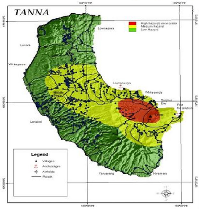 |
Figure 44. This danger map ('Denja Map') of Tanna Island containing Yasur volcano shows Red, Yellow, and Green zones to warn visitors and civilians of ashfall and other hazards. Yasur volcano is near the eastern end of the red, highest-risk zone. Map key and title are in a language with phonetic similarities to English that evolved with contact from traders (a lingua franca) but many other languages also remain in use in Vanuatu. Ash could likely fall well W of Yasur due to trade winds from the ESE. This image is of low to moderate resolution and some symbols are illegible. Courtesy of Vanuatu Geohazards Observatory. |
Observations and seismic data from early to mid-August 2013 suggested that explosive activity of the volcano had decreased slightly during that time. Explosions were weaker and less frequent. Therefore, on 29 August 2013, the VGO decreased the Alert Level from 2, where it had been since early April 2013, to 1. Level 1 (on a scale of 0-4) indicates "increased activity [but] danger near crater only". From 29 August 2013 until at least February 2014, the Alert Level has remained at 1.
According to John Search, who has led tours of the volcano since 1998, activity increased beginning October 2013. A large ash emission caused widespread damage to vegetation on Tanna Island, and ashfall was reported on Erromango Island, 150 km N of Yasur. On the evening of 3 November 2013, Search witnessed large Strombolian explosions. These explosions ejected volcanic bombs, up to 4 m in diameter, 250 m from the vent, putting visitors at risk. According to Search, the explosions were some of the largest at Yasur since 1995.
On 19 November 2013, VGO reported that a new phase of ash emissions began on 3 November. The explosive intensity remained low.
Geological Summary. Yasur has exhibited essentially continuous Strombolian and Vulcanian activity at least since Captain Cook observed ash eruptions in 1774. This style of activity may have continued for the past 800 years. Located at the SE tip of Tanna Island in Vanuatu, this pyroclastic cone has a nearly circular, 400-m-wide summit crater. The active cone is largely contained within the small Yenkahe caldera, and is the youngest of a group of Holocene volcanic centers constructed over the down-dropped NE flank of the Pleistocene Tukosmeru volcano. The Yenkahe horst is located within the Siwi ring fracture, a 4-km-wide open feature associated with eruption of the andesitic Siwi pyroclastic sequence. Active tectonism along the Yenkahe horst accompanying eruptions has raised Port Resolution harbor more than 20 m during the past century.
Information Contacts: Vanuatu Geohazards Observatory, Department of Geology, Mines and Water Resources of Vanuatu (URL: http://www.geohazards.gov.vu); John Seach, Volcanolive.com (URL: Volcanolive.com/Yasur.html); and Volcano Discovery (www.volcanodiscovery.com).