Report on Reventador (Ecuador) — July 2014

Bulletin of the Global Volcanism Network, vol. 39, no. 7 (July 2014)
Managing Editor: GVP Staff.
Reventador (Ecuador) Ongoing ash emissions, lava flows, and pyroclastic flows through July 2014
Please cite this report as:
Global Volcanism Program, 2014. Report on Reventador (Ecuador) (GVP Staff, ed.). Bulletin of the Global Volcanism Network, 39:7. Smithsonian Institution. https://doi.org/10.5479/si.GVP.BGVN201407-352010
Reventador
Ecuador
0.077°S, 77.656°W; summit elev. 3562 m
All times are local (unless otherwise noted)
The last Bulletin report covered activity at Reventador through April 2013 (BGVN 38:06). This report details activity occurring between May 2013 and July 2014, and is primarily based on available reports published by Ecuador's Instituto Geofísico-Escuela Politécnica Nacional (IG) and Washington Volcanic Ash Advisory Center (VAAC) notices. Activity during this interval was characterized by periods of varying seismicity; lava flow production; emissions of ash, water vapor, and gases; pyroclastic flows (PFs); incandescence; and lahars.
This report represents a synthesis of activity at Reventador, emphasizing events that occurred during intervals of higher activity described in various IG publications. Data from IG was not available during all or parts of June-July and October-December 2013, and Jan-March and June 2014 (figure 42). Emission columns of water vapor, ash and gas were often observed, along with some incandescence at night in the crater area (table 7). The tallest plumes during this reporting interval reached between 7.6 and 8.6 km altitude. Pyroclastic flows also sometimes occurred during periods of moderate seismicity.
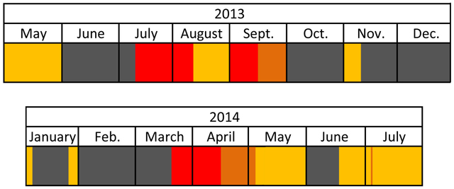 |
Figure 42. Timeline of IG data availability and seismicity levels at Reventador during May 2013-July 2014. Key to colors: high seismicity (red); moderate to high seismicity (burnt orange); moderate seismicity (golden yellow); IG data unavailable (gray). |
Table 7. Summary of Reventador's emissions reaching 4.6 km and greater in altitude (1 km height above the summit) during May 2013 through July 2014. Reports courtesy of IG and Washington VAAC.
| Date | Description of activity |
| 01 May 2013 | VAAC reported seismicity was elevated during the night. Ash plume to 7 km. |
| 08 May 2013 | Incandescence at dawn. Vapor emissions with ash to 4.6 km, drifting NW. |
| 10 May 2013 | Vapor emission with low ash content to 4.6 km. |
| 20 Jun 2013 | The VAAC stated seismic activity was consistent with emissions containing ash or gases, to 4.9 km. |
| 18 Jul 2013 | Ash dispersed in the surroundings of the cone. Emission of gases and ash to ~4.6 km. |
| 10 Aug 2013 | Small emissions of vapor and in some cases, ash; some rose up to 4.6 km. |
| 06 Sep 2013 | Pyroclastic flow (PF) on SE flank. Emissions with ash to 6.6 km |
| 07 Sep 2013 | Low energy emissions of gas and ash to less than 5.6 km. |
| 22 Sep 2013 | Deposit of a PF on S side of cone. Low energy water vapor emissions containing ash to less than 5.6 km. |
| 02 Nov 2013 | Emission was generated by a moderate sized explosion at 0754 local time to ~5.6 km drifting SE. PF generated on W flank of cone. Ashfall reported in San Rafael (8 km ESE). |
| 02 Nov 2013 | At 1037 local time, VAAC reported that a pilot observed volcanic ash to 6.7 km. |
| 31 Dec 2013 | VAAC reported that the ash plume was observed by a pilot to 4.9 km. |
| 25 Mar 2014 | Sustained emission tremor produced the ash and gas emission columns to 5.1 km drifting W and SW. PFs and lava flows also observed. |
| 28 Mar 2014 | Emissions observed during the morning with small amount sof ash to 4.6 km. |
| 02 Apr 2014 | Vapor emission with high content of ash to ~6.6 km drifting SE. |
| 01 May 2014 | Brightness observed in the area of the crater at night. Emissions containing small amounts of ash at 6.6-7.6 km drifting W. |
| 04 May 2014 | Various explosions occurred during the night, one of which ejected a large amount of incandescent material that descended most flanks. Continuous emissions of gas and ash to 7.6-8.6 km drifting NW. |
| 05 May 2014 | Brightness observed at the summit. Mainly white emissions produced, rising up to 7.6 km drifting NW |
| 20 May 2014 | Emissions of vapor to 5.6 km drifting NW. |
| 23 May 2014 | Water vapor and ash emissions to 4.6 km drifting NW. |
| 30 May 2014 | Ash plume was generated by a moderate sized explosion to 6.5 km; reported by a pilot. |
| 20 Jun 2014 | Emission column to 5.6 km drifting NW. |
| 02 Jul 2014 | An explosion during the morning generated a column of vapor and ash to 5.6 km drifting SE. PF also reported. |
| 09 Jul 2014 | Vapor emissions with moderate amounts of ash to 5.6 km observed in the morning. |
| 10 Jul 2014 | Diffuse ash emission observed in the afternoon to 5.1 km drifting NW; hidden by clouds for most of the morning. |
| 11 Jul 2014 | Diffuse ash emission in the morning to 5.1 km drifting NW. |
| 23 Jul 2014 | Emission column to 4.6 km. |
Activity during July-November 2013. Seismicity was high from 10 July to 8 August 2013, consisting of long-period (LP) events (30-130/day), explosions (1-51/day), emission tremor episodes (2-18/day), and harmonic tremor episodes (2-7/day). The elevated seismicity corresponded to lava flows, incandescence, and explosions. On 13 July 2013 a new lava flow on the S flank was detected. Continuous tremor was detected during the afternoon of 15 July and, at 2000 that night, the tremor intensified. Intense Strombolian activity, with explosions of variable magnitudes, associated roars, and 'cannon shots' were reported. Incandescence was also observed on the SW flank on 16 July. Another new lava flow was seen on the E flank on 18 July and, on 19 July lava flows descended the S and E flanks. Numerous rockfalls were recorded between 15 and 25 July; with a high of 65 on 23 July. During the night of 7 August, incandescent material was ejected onto the SW flank and explosions were heard.
A period of high seismic activity also occurred during 4-14 September 2013, again with LPs (40-90/day), explosions (2-50/day), emission tremor episodes (3-19/day), and harmonic tremor episodes (2-36/day). Explosions triggered pyroclastic flows which traveled ~1.5 km down the SE flank on 6 September. Explosive events were frequent between 4 and 7 September, and small pyroclastic flows affecting the top part of the cone were observed on 7 September. A new lava flow that had traveled 1 km down the SE flank was identified in the morning of 8 September. There was a great accumulation of pyroclastic material in the crater and on the upper flanks, which caused continuous avalanches of tephra. Moderate to high seismic activity was recorded during 15-25 September 2013. A strong explosion and pyroclastic flow on the S side of the cone was reported on 22 September.
A moderate explosion at 0754 on 2 November 2013 generated a vapor-and-ash plume that rose to an altitude of 5.6 km and drifted SE.
Activity during March-July 2014. Another period of high seismicity was recorded between 25 March and 13 April 2014. Daily recordings for seismic events during this period ranged from 40-103 for LPs, 10-30 for explosions, 6-195 for episodes of emission tremor, and 2-55 for episodes of harmonic tremor. Elevated activity that began on 25 March 2014 began at 1500 was characterized by a sustained emission tremor, gas emissions containing variable amounts of ash, and ejected material being deposited around the crater. Partial dome collapse caused pyroclastic flows down the E, SE and S flanks, travelling up to 1.5 km from the summit (figures 43 and 44). At least two lava flows were observed descending ~500 m from the crater along the E and SE flanks.
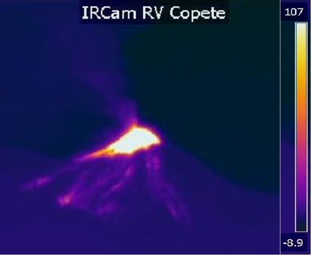 |
Figure 43. Thermal infrared image showing secondary pyroclastic flows at Reventador as thin trails, below a larger bright spot of hot material, which was described as an ash cone. This image was captured at 1820 local time (2320 UTC) on 25 March 2014. The thermal camera that captured this image is located in the Copete Sector of Reventador. Thermal scale on the right side of the figure is in degrees Celsius (°C). Courtesy of Instituto Geofísico-Escuela Politécnica Nacional (IG). |
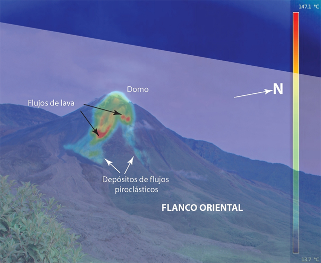 |
Figure 44. The superposition of a thermal image and a photo showing deposits of the secondary PFs and lava flows that developed due to the increased activity on 25 March 2014. The English translations of the Spanish words on the figure are as follows: flanco oriental, E flank; domo, dome; flujos de lava, lava flows; and depósitos de flujos piroclásticos, pyroclastic flow deposits. Courtesy of Instituto Geofísico-Escuela Politécnica Nacional (IG). |
From 27 March to 11 April 2014, numerous lava flows were observed. On 27 March a lava flow on the S flank was observed by video cameras, and hot spots on that flank were captured through thermal images on 29 March. In the early morning of 31 March, after a large roar was reported, incandescent blocks and lava flows traveled 1 km down the S flank. Lahars produced by rainfall were reported during the morning of 2 April 2014. Four lava flows on the S and SE flanks were observed on 3 April and continued to be active through 8 April. Lava flows were also observed on the SW flank on 9 and 11 April.
During the moderate to high seismicty of 14 April-2 May 2014, IG reported that a small PF descended only a few meters below the crater. On 2 May, thermal cameras captured the movement of lava flows on the S and SE flanks. On the night of 4 May 2014, at 2040 local time, an explosion ejected a great quantity of incandescent material which descended most of Reventador's flanks. Infrared cameras detected the descent of incandescent material on the S and E flanks on the night of 17 June. Incandescent material on 19 June moved down the NE flank and an emission plume was generated.
At 0650 local time on 2 July 2014, a large explosion produced a plume which subsequently collapsed and formed a PF (figure 45). The PF moved about 1.5 km down the S flank and the plume contained moderate amounts of ash drifted W. Another explosion released a column of vapor and ash that rose to an altitude of 5.6 km and drifted SE. On 3 July 2014, there were 42 LP events recorded, which was higher than the number of LP events recorded on 1 and 2 July (18 and 27, respectively). During the evening of 26 July 2014, an explosion formed a PF which traveled almost 1 km down the SW flank.
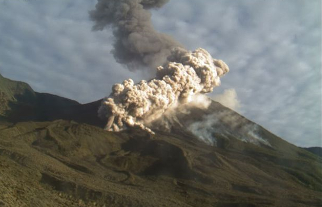 |
Figure 45. Photo of a pyroclastic flow and ash column at Reventador on the morning of 2 July 2014. This image was captured by an IG camera, located on the SE flank. Courtesy of IG. |
Geological Summary. Volcán El Reventador is the most frequently active of a chain of Ecuadorian volcanoes in the Cordillera Real, well east of the principal volcanic axis. The forested, dominantly andesitic stratovolcano has 4-km-wide avalanche scarp open to the E formed by edifice collapse. A young, unvegetated, cone rises from the amphitheater floor to a height comparable to the rim. It has been the source of numerous lava flows as well as explosive eruptions visible from Quito, about 90 km ESE. Frequent lahars in this region of heavy rainfall have left extensive deposits on the scarp slope. The largest recorded eruption took place in 2002, producing a 17-km-high eruption column, pyroclastic flows that traveled up to 8 km, and lava flows from summit and flank vents.
Information Contacts: Instituto Geofísico-Escuela Politécnica Nacional (IG), Casilla 17-01-2759, Quito, Ecuador (URL: http://www.igepn.edu.ec/); Washington Volcanic Ash Advisory Center (VAAC), Satellite Analysis Branch (SAB), NOAA/NESDIS E/SP23, NOAA Science Center Room 401, 5200 Auth Rd, Camp Springs, MD 20746, USA (URL: http://www.ospo.noaa.gov/Products/atmosphere/vaac/).