Report on Unnamed (Tonga) — June 2017
Bulletin of the Global Volcanism Network, vol. 42, no. 6 (June 2017)
Managing Editor: Edward Venzke.
Research and preparation by Robert Andrews.
Unnamed (Tonga) Plumes of discolored water seen in satellite imagery during 23-28 January 2017
Please cite this report as:
Global Volcanism Program, 2017. Report on Unnamed (Tonga) (Venzke, E., ed.). Bulletin of the Global Volcanism Network, 42:6. Smithsonian Institution. https://doi.org/10.5479/si.GVP.BGVN201706-243030
Unnamed
Tonga
20.852°S, 175.55°W; summit elev. -296 m
All times are local (unless otherwise noted)
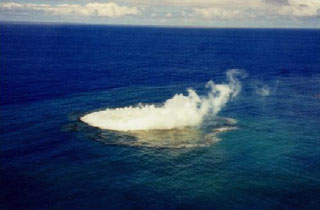
Murray Ford, a coastal geomorphologist from New Zealand's Auckland University, reported in a Radio New Zealand story on 1 February 2017 that satellite imagery showed a large plume of discolored water between Tongatapu and the volcanic Hunga Tonga-Hunga Ha'apai islands. The activity seen by Murray was on a Landsat 8 OLI (Operational Land Imager) satellite image acquired on 27 January 2017 (figure 2). which showed a bright area of discolored water above the summit and a broader area of discolored water immediately NW, likely from previous events. According to volcanologist Brad Scott (GNS Science) there are additional satellite images from 23, 26, 28, and 29 January 2017, indicating that the eruption had been ongoing for over a week. His colleagues in Tonga indicated a possible associated steam plume, but cloud cover made observations uncertain.
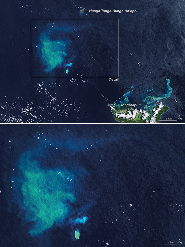 |
Figure 2. Landsat 8 OLI satellite image a submarine plume from an unnamed seamount in Tonga on 27 January 2017, about 33 km NW of Tongatapu island. A small bright area of discolored water is directly over the summit (bottom center), with a small plume immediately N, and a broad area of discolored water to the NW, likely from previous eruptive events. The larger plume to the NW measures 30 km long and 20 km wide. Courtesy of NASA Earth Observatory. |
A report prepared by Taylor (2000) noted that there had been four previous reports of activity from this location: submarine activity in August 1911, a steam plume in July 1923, discolored water in 1970, and an ephemeral island near the end of an eruptive episode during 27 December 1998-14 January 1999 (also see BGVN 24:03). In a blog post about the latest eruption, Brad Scott (GNS Science) also stated that there had been discolored water and felt earthquakes sometime in 2007.
Reference: Taylor, P., 2000, A volcanic hazards assessment following the January 1999 eruption of Submarine Volcano III, Tofua Volcanic Arc, Kingdom of Tonga, Australian Volcanological Investigations (AVI) Occasional Report No. 99/01, 5 August 2000, 7 p.
Geological Summary. An unnamed submarine volcano is located along the Tofus volcanic arc 35 km NW of the Niu Aunofo lighthouse on Tongatapu Island. The first documented eruptions took place in 1911 and 1923; an ephemeral island was formed in 1999. A submarine eruption in January 2017 produced discolored water visible in satellite imagery.
Information Contacts: NASA Earth Observatory, EOS Project Science Office, NASA Goddard Space Flight Center, Goddard, Maryland, USA (URL: http://earthobservatory.nasa.gov/, https://earthobservatory.nasa.gov/images/89565/underwater-eruption-near-tongatapu); Brad Scott, New Zealand GeoNet Project, a collaboration between the Earthquake Commission and GNS Science, Wairakei Research Centre, Private Bag 2000, Taupo 3352, New Zealand (URL: http://www.geonet.org.nz/, http://www.geonet.org.nz/news/1usjOmF4LqaI64qScMocuW); Radio New Zealand (URL: http://www.radionz.co.nz/international/pacific-news/323569/scientist-discovers-underwater-eruption-in-tonga).