Report on Mayotte (France) — March 2020
Bulletin of the Global Volcanism Network, vol. 45, no. 3 (March 2020)
Managing Editor: Edward Venzke.
Edited by Kadie L. Bennis.
Mayotte (France) Seismicity and deformation, with submarine E-flank volcanism starting in July 2018
Please cite this report as:
Global Volcanism Program, 2020. Report on Mayotte (France) (Bennis, K.L., and Venzke, E., eds.). Bulletin of the Global Volcanism Network, 45:3. Smithsonian Institution. https://doi.org/10.5479/si.GVP.BGVN202003-233005
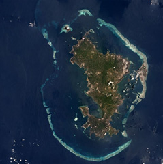
Mayotte
France
12.83°S, 45.17°E; summit elev. 660 m
All times are local (unless otherwise noted)
Mayotte is a volcanic island in the Comoros archipelago between the eastern coast of Africa and the northern tip of Madagascar. A chain of basaltic volcanism began 10-20 million years ago and migrating W, making up four principal volcanic islands, according to the Institut de Physique du Globe de Paris (IPGP) and Cesca et al. (2020). Before May 2010, only two seismic events had been felt by the nearby community within recent decades. New activity since May 2018 consists of dominantly seismic events and lava effusion. The primary source of information for this report through February 2020 comes from semi-monthly reports from the Réseau de Surveillance Volcanologique et Sismologique de Mayotte (REVOSIMA), a cooperative program between the Institut de Physique du Globe de Paris (IPGP), the Bureau de Recherches Géologiques et Minières (BRGM), and the Observatoire Volcanologique du Piton de la Fournaise (OVPF-IPGP); Lemoine et al. (2019), the Centre National de la Recherche Scientifique (CNRS), and the Institut Français de Recherche pour l'Exploitation de la Mer (IFREMER).
Seismicity was the dominant type of activity recorded in association with a new submarine eruption. On 10 May 2018, the first seismic event occurred at 0814, detected by the YTMZ accelerometer from the French RAP Network, according to BRGM and Lemoine et al. (2019). Seismicity continued to increase during 13-15 May 2018, with the strongest recorded event for the Comoros area occurring on 15 May at 1848 and two more events on 20-21 May (figure 1). At the time, no surface effusion were directly observed; however, Global Navigation Satellite System (GNSS) instruments were deployed to monitor any ground motion (Lemoine et al. 2019).
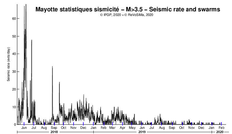 |
Figure 1. A graph showing the number of daily seismic events greater than M 3.5 occurring offshore of Mayotte from 10 May 2018 through 15 February 2020. Seismicity significantly decreased in July 2018, but continued intermittently through February 2020, with relatively higher seismicity recorded in late August and mid-September 2018. Courtesy of IPGP and REVOSIMA. |
Seismicity decreased dramatically after June 2018, with two spikes in August and September (see figure 1). Much of this seismicity occurred offshore 50 km E of Mayotte Island (figure 2). The École Normale Supérieure, the Observatoire Volcanologique du Piton de la Fournaise (OVPF-IPGP), and the REVOSIMA August 2019 bulletin reported that measurements from the GNSS stations and Teria GPS network data indicated eastward surface deformation and subsidence beginning in July 2018. Based on this ground deformation data Lemoine et al. (2019) determined that the eruptive phase began fifty days after the initial seismic events occurred, on 3 July 2018.
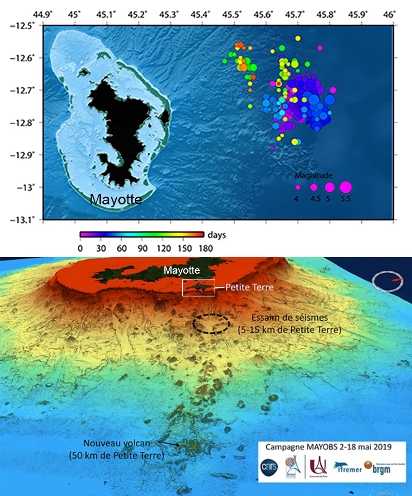 |
Figure 2. Maps of seismic activity offshore near Mayotte during May 2019. Seismic swarms occurred E of Mayotte Island (top) and continued in multiple phases through October 2019. New lava effusions were observed 50 km E of Petite Terre (bottom). Bottom image has been modified with annotations; courtesy of IPGP, BRGM, IFREMER, CNRS, and University of Paris. |
Between 2 and 18 May 2019, an oceanographic campaign (MAYOBS 1) discovered a new submarine eruption site 50 km E from the island of Mayotte (figure 2). The director of IPGP, Marc Chaussidon, stated in an interview with Science Magazine that multibeam sonar waves were used to determine the elevation (800 m) and diameter (5 km) of the new submarine cone (figure 3). In addition, this multibeam sonar image showed fluid plumes within the water column rising from the center and flanks of the structure. According to REVOSIMA, these plumes rose to 1 km above the summit of the cone but did not breach the ocean surface. The seafloor image (figure 3) also indicated that as much as 5 km3 of magma erupted onto the seafloor from this new edifice during May 2019, according to Science Magazine.
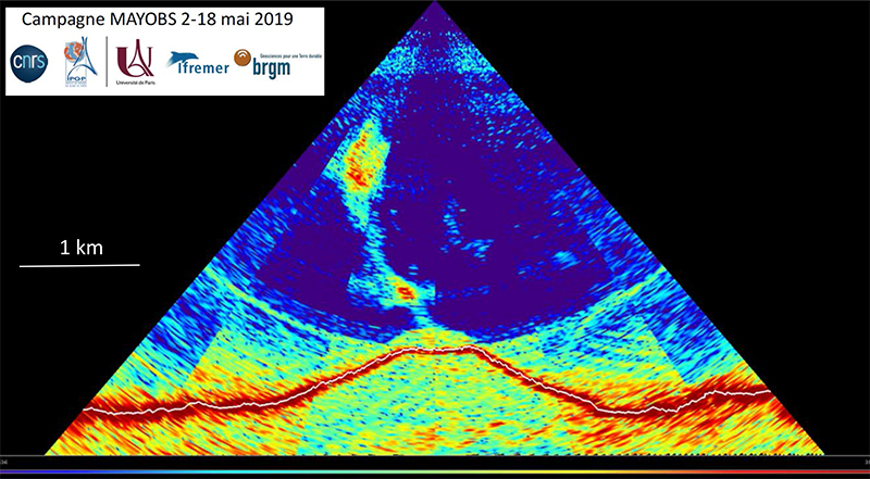 |
Figure 3. Seafloor image of the submarine vent offshore of Mayotte created with multibeam sonar from 2 to 18 May 2019. The red line is the outline of the volcanic cone located at approximately 3.5 km depth. The blue-green color rising from the peak of the red outline represents fluid plumes within the water column. Courtesy of IPGP. |
On 17 May 2019, a second oceanographic campaign (MAYOBS 2) discovered new lava flows located 5 km S of the new eruptive site. BRGM reported that in June a new lava flow had been identified on the W flank of the cone measuring 150 m thick with an estimated volume of 0.3 km3 (figure 4). According to REVOSIMA, the presence of multiple new lava flows would suggest multiple effusion points. Over a period of 11 months (July 2018-June 2019) the rate of lava effusion was at least 150-200 m3/s; between 18 May to 17 June 2019, 0.2 km3 of lava was produced, and from 17 June to 30 July 2019, 0.3 km3 of lava was produced. The MAYOBS 4 (19 July 2019-4 August 2019) and SHOM (20-21 August 2019) missions revealed a new lava flow formed between 31 July and 20 August to the NW of the eruptive site with a volume of 0.08 km3 and covering 3.25 km2.
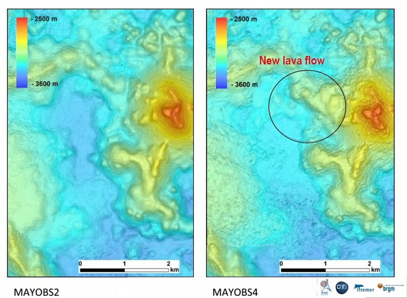 |
Figure 4. Bathymetric map showing the location of the new lava flow on the W flank of the submarine cone offshore to the E of Mayotte Island. The MAYOBS 2 campaign was launched in June 2019 (left) and MAYOBS 4 was launched in late July 2019 (right). Courtesy of BRGM. |
During the MAYOBS 4 campaign in late July 2019, scientists dredged the NE flank of the cone for samples and took photographs of the newly erupted lava (figure 5). Two dives found the presence of pillow lavas. When samples were brought up to the surface, they exploded due to the large amount of gas and rapid decompression.
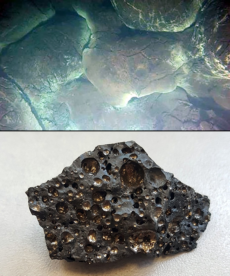 |
Figure 5. Photographs taken using the submersible interactive camera system (SCAMPI) of newly formed pillow lavas (top) and a vesicular sample (bottom) dredged near the new submarine eruptive site at Mayotte in late July 2019. Courtesy of BRGM. |
During April-May 2019 the rate of ground deformation slowed. Deflation was also observed up to 90 km E of Mayotte in late October 2019 and consistently between August 2019 and February 2020. Seismicity continued intermittently through February 2020 offshore E of Mayotte Island, though the number of detected events started to decrease in July 2018 (see figure 1). Though seismicity and deformation continued, the most recent observation of new lava flows occurred during the MAYOBS 4 and SHOM campaigns on 20 August 2019, as reported in REVOSIMA bulletins.
References: Cesca S, Heimann S, Letort J, Razafindrakoto H N T, Dahm T, Cotton F, 2020. Seismic catalogues of the 2018-2019 volcano-seismic crisis offshore Mayotte, Comoro Islands. Nat. Geosci. 13, 87-93. https://doi.org/10.1038/s41561-019-0505-5.
Lemoine A, Bertil D, Roulle A, Briole P, 2019. The volcano-tectonic crisis of 2018 east of Mayotte, Comoros islands. Preprint submitted to EarthArXiv, 28 February 2019. https://doi.org/10.31223/osf.io/d46xj.
Geological Summary. Mayotte, located in the Mozambique Channel between the northern tip of Madagascar and the eastern coast of Africa, consists two main volcanic islands, Grande Terre and Petite Terre, and roughly twenty islets within a barrier-reef lagoon complex (Zinke et al., 2005; Pelleter et al., 2014). Volcanism began roughly 15-10 million years ago (Pelleter et al., 2014; Nougier et al., 1986), and has included basaltic lava flows, nephelinite, tephrite, phonolitic domes, and pyroclastic deposits (Nehlig et al., 2013). Lavas on the NE were active from about 4.7 to 1.4 million years and on the south from about 7.7 to 2.7 million years. Mafic activity resumed on the north from about 2.9 to 1.2 million years and on the south from about 2 to 1.5 million years. Several pumice layers found in cores on the barrier reef-lagoon complex indicate that volcanism likely occurred less than 7,000 years ago (Zinke et al., 2003). More recent activity that began in May 2018 consisted of seismicity and ground deformation occurring offshore E of Mayotte Island (Lemoine et al., 2019). One year later, in May 2019, a new subaqueous edifice and associated lava flows were observed 50 km E of Petite Terre during an oceanographic campaign.
Information Contacts: Réseau de Surveillance Volcanologique et Sismologique de Mayotte (REVOSIMA), a cooperative program of a) Institut de Physique du Globe de Paris (IPGP), b) Bureau de Recherches Géologiques et Minières (BRGM), c) Observatoire Volcanologique du Piton de la Fournaise (OVPF-IPGP); (URL: http://www.ipgp.fr/fr/reseau-de-surveillance-volcanologique-sismologique-de-mayotte); Observatoire Volcanologique du Piton de la Fournaise, Institut de Physique du Globe de Paris, 14 route nationale 3, 27 ème km, 97418 La Plaine des Cafres, La Réunion, France (URL: http://www.ipgp.fr/fr); Bureau de Recherches Géologiques et Minières (BRGM), 3 avenue Claude-Guillemin, BP 36009, 45060 Orléans Cedex 2, France (URL: https://www.brgm.fr/); Institut Français de Recherche pour l'Exploitation de la Mer (IFREMER), 1625 route de Sainte-Anne, CS 10070, 29280 Plouzané, France (URL: https://wwz.ifremer.fr/); Centre National de la Recherche Scientifique (CNRS), 3 rue Michel-Ange, 75016 Paris, France (URL: http://www.cnrs.fr/); École Normale Supérieure, 45 rue d'Ulm, F-75230 Paris Cedex 05, France (URL: https://www.ens.psl.eu/); Université de Paris, 85 boulevard Saint-Germain, 75006 Paris, France (URL: https://u-paris.fr/en/498-2/); Roland Pease, Science Magazine (URL: https://science.sciencemag.org/, article at https://www.sciencemag.org/news/2019/05/ship-spies-largest-underwater-eruption-ever) published 21 May 2019.