Report on Barren Island (India) — March 2021

Bulletin of the Global Volcanism Network, vol. 46, no. 3 (March 2021)
Managing Editor: Edward Venzke.
Edited by A. Elizabeth Crafford.
Barren Island (India) Ash emissions in November and December 2020, then thermal anomalies through February 2021
Please cite this report as:
Global Volcanism Program, 2021. Report on Barren Island (India) (Crafford, A.E., and Venzke, E., eds.). Bulletin of the Global Volcanism Network, 46:3. Smithsonian Institution. https://doi.org/10.5479/si.GVP.BGVN202103-260010
Barren Island
India
12.278°N, 93.858°E; summit elev. 354 m
All times are local (unless otherwise noted)
Barren Island, an uninhabited possession of India in the Andaman Sea, had numerous historical eruptions observed during 1787-1832. No further evidence of activity was found until 1991 when ash plumes, Strombolian explosions, and lava flows that reached the ocean were observed. Intermittent similar eruptions since 2005 have lasted for months to years. Its remoteness makes ground observations rare, but satellite data and reports from the Darwin VAAC (Volcanic Ash Advisory Center) suggest that the most recent eruption which began in September 2018 with lava fountaining, lava flows, and ash emissions has continued with intermittent thermal anomalies at the summit and minor ash emissions since early 2019. This report covers activity from July 2020-February 2021.
The MIROVA thermal anomaly data from April 2020 through February 2021 indicate low levels of thermal activity from April through October 2020. Pulses of activity in early November and late January-early February 2021 correspond to increased thermal activity seen in satellite images during that time (figure 47). Ash emissions were reported by the Darwin VAAC in early November and early December 2020. A strong thermal anomaly was present in satellite imagery on 11 November, and moderate anomalies appeared during February 2021. In addition, during November-February faint thermal anomalies and/or small ash emissions were present in one or more satellite images each month.
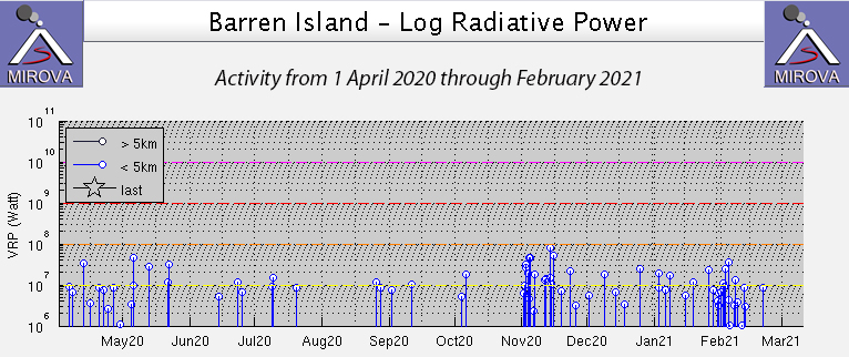 |
Figure 47. The MIROVA thermal anomaly data from April 2020 through February 2021 indicate low levels of thermal activity from April through October 2020. Pulses of activity in early November and late January-early February 2021 corresponded to increased thermal activity seen in satellite images. Courtesy of MIROVA. |
After a small ash plume was observed on 24 June 2020 in Sentinel-2 satellite imagery (BGVN 45:08), the only evidence of further activity was a very weak thermal anomaly present inside the summit crater of the pyroclastic cone on 19 July 2020. Satellite images were mostly cloudy during August-October 2020, although the few clear images each month showed no sign of thermal anomalies or ash emissions. Single MODVOLC thermal alerts were issued for Barren Island on 2 and 4 November 2020. The Darwin VAAC reported continuous ash emissions drifting SW at 1.5 km altitude on 5 November. A very faint thermal anomaly was present inside the summit of the pyroclastic cone the next day. A large thermal anomaly and small ash plume were captured in satellite images on 11 November (figure 48). The bright anomaly at the center of the cone was surrounded by a weaker anomaly suggesting incandescent ejecta on the flanks of the cone. A smaller thermal anomaly and similar ash plume were visible in the 16 November 2020 Sentinel-2 satellite images (figure 49).
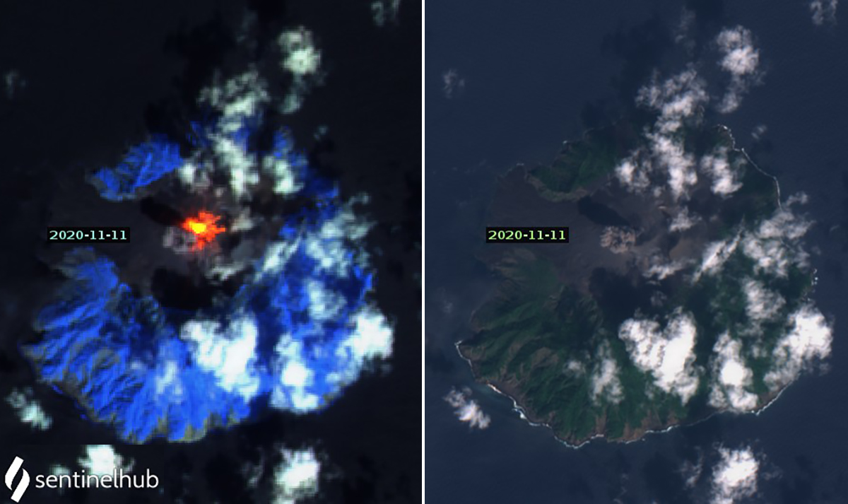 |
Figure 48. A large thermal anomaly and small ash plume at Barren Island were captured in Sentinel-2 satellite images on 11 November 2020. In the left image the bright anomaly at the center of the cone was surrounded by a weaker anomaly suggesting incandescent ejecta on the flanks of the cone. Image uses Atmospheric penetration rendering (bands 12, 11, 8a). The ash emission immediately W of the summit crater is more visible in the Natural color rendering (right, bands 4,3,2). Courtesy of Sentinel Hub Playground. |
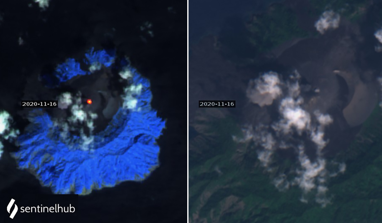 |
Figure 49. A thermal anomaly at the summit and a discrete ash emission slightly W of the summit of Barren Island were captured in Sentinel-2 satellite imagery on 16 November 2020. Left image uses Atmospheric penetration rendering (bands 12, 11, 8a) and right image shows a closeup of the summit and ash plume in Natural color rendering (bands 4, 3, 2). Courtesy of Sentinel Hub Playground. |
The Darwin VAAC issued an ash advisory on 8 December 2020 of an ash plume drifting W at 1.8 km altitude. It was only visible in satellite imagery for about two hours before dissipating. A small thermal anomaly appeared at the summit on 21 December. During January 2021 faint thermal anomalies were visible on 5, 20, and 25 January, and ash plumes could be seen on 15 and 25 January in Sentinel-2 images (figure 50). The strength of the thermal activity increased during February 2021, with satellite evidence recorded on 4, 9, 19, and 24 February; an ash emission was visible on 9 February (figure 51).
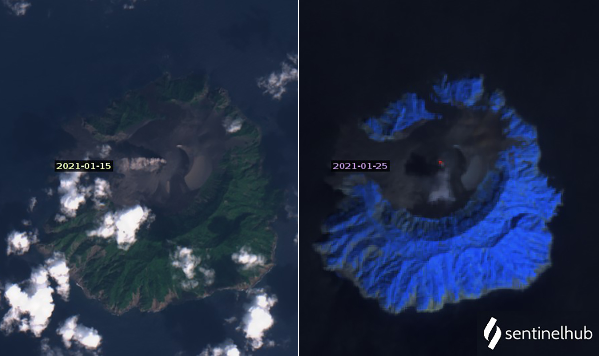 |
Figure 50. Ash plumes and thermal anomalies at Barren Island were present in Sentinel-2 satellite images several times during January 2021. The left image from 15 January shows an ash plume drifting W from the summit using Natural color rendering (bands 4, 3, 2). The right image shows a weak thermal anomaly at the summit on 25 January with an ash plume drifting S using Atmospheric penetration rendering (bands 12, 11, and 8A). Courtesy of Sentinel Hub Playground. |
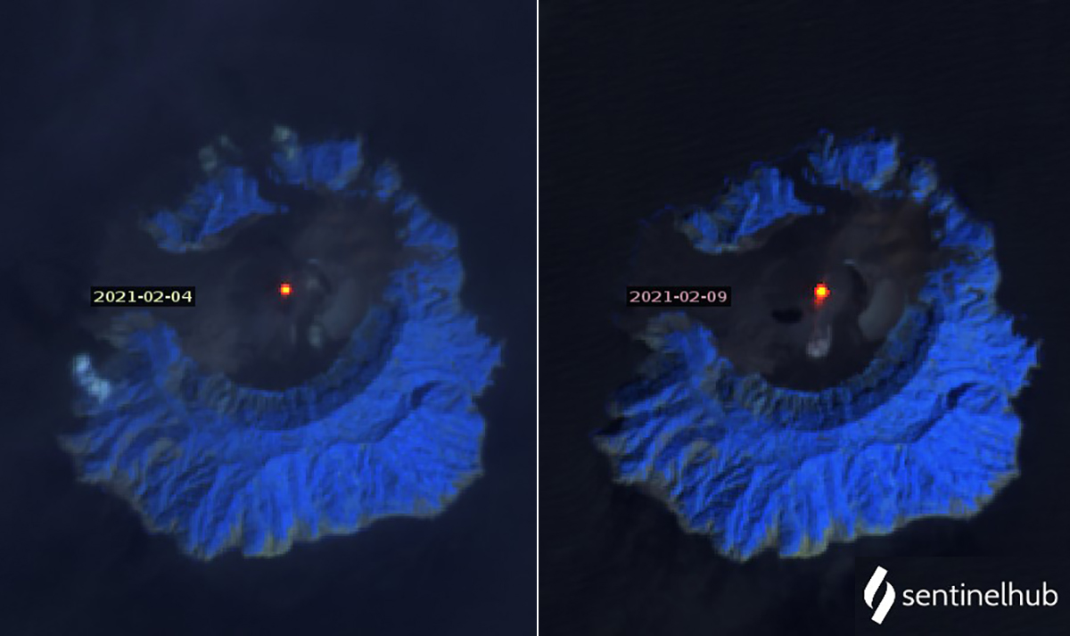 |
Figure 51. Sentinel-2 satellite images showed thermal anomalies at Barren Island several times during February 2020 including on 4 (left) and 9 (right) February. An ash emission drifted S from the summit on 9 February. Images use Atmospheric penetration rendering (bands 12, 11, 8a). Courtesy of Sentinel Hub Playground. |
Geological Summary. Barren Island, a possession of India in the Andaman Sea about 135 km NE of Port Blair in the Andaman Islands, is the only historically active volcano along the N-S volcanic arc extending between Sumatra and Burma (Myanmar). It is the emergent summit of a volcano that rises from a depth of about 2250 m. The small, uninhabited 3-km-wide island contains a roughly 2-km-wide caldera with walls 250-350 m high. The caldera, which is open to the sea on the west, was created during a major explosive eruption in the late Pleistocene that produced pyroclastic-flow and -surge deposits. Historical eruptions have changed the morphology of the pyroclastic cone in the center of the caldera, and lava flows that fill much of the caldera floor have reached the sea along the western coast.
Information Contacts: Sentinel Hub Playground (URL: https://www.sentinel-hub.com/explore/sentinel-playground); Darwin Volcanic Ash Advisory Centre (VAAC), Bureau of Meteorology, Northern Territory Regional Office, PO Box 40050, Casuarina, NT 0811, Australia (URL: http://www.bom.gov.au/info/vaac/); MIROVA (Middle InfraRed Observation of Volcanic Activity), a collaborative project between the Universities of Turin and Florence (Italy) supported by the Centre for Volcanic Risk of the Italian Civil Protection Department (URL: http://www.mirovaweb.it/); Hawai'i Institute of Geophysics and Planetology (HIGP) - MODVOLC Thermal Alerts System, School of Ocean and Earth Science and Technology (SOEST), Univ. of Hawai'i, 2525 Correa Road, Honolulu, HI 96822, USA (URL: http://modis.higp.hawaii.edu/).