Report on Chirinkotan (Russia) — October 2021
Bulletin of the Global Volcanism Network, vol. 46, no. 10 (October 2021)
Managing Editor: Benjamin Andrews.
Edited by Kadie L. Bennis.
Chirinkotan (Russia) Explosions and intermittent ash plumes during August 2021
Please cite this report as:
Global Volcanism Program, 2021. Report on Chirinkotan (Russia) (Bennis, K.L., and Andrews, B., eds.). Bulletin of the Global Volcanism Network, 46:10. Smithsonian Institution. https://doi.org/10.5479/si.GVP.BGVN202110-290260
Chirinkotan
Russia
48.98°N, 153.48°E; summit elev. 724 m
All times are local (unless otherwise noted)
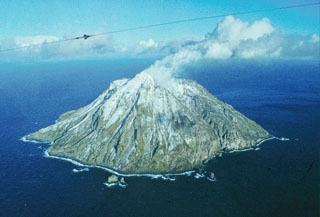
Chirinkotan is a small 3-km-wide remote island located in the Northern Kuril Islands at the southern end of the Sea of Okhotsk, about 320 km SW of the tip of Kamchatka, Russia. Historical eruptions have been recorded since the 18th century and one confirmed eruption in the 19th century reported lava flows. More recently, an eruption that began in late November 2016 consisted of intermittent ash plumes (BGVN 42:06). This report covers brief activity during August-September 2021 characterized by explosions and ash plumes, according to information from daily, weekly, and special reports from the Kamchatka Volcanic Eruptions Response Team (KVERT), the Sakhalin Volcanic Eruption Response Team (SVERT), the Tokyo Volcanic Ash Advisory Center (VAAC), and satellite data.
There were no reports of significant activity during May 2017 through July 2021. Few low-power thermal anomalies were recorded by the MIROVA (Middle InfraRed Observation of Volcanic Activity) system during March through September 2021, with periods of no thermal activity (figure 8). No anomalies were detected December 2020-February 2021, May, and August. Three thermal anomalies were detected during March, two during April, four during June, four during July, and four during the end of September.
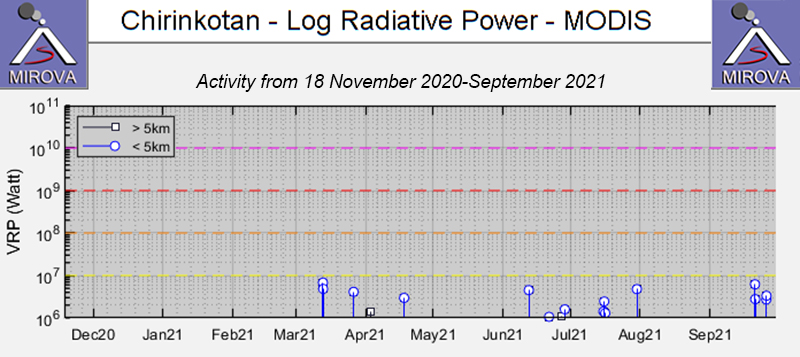 |
Figure 8. MIROVA (Log Radiative Power) thermal data for Chirinkotan during March-September 2021 showing low-power thermal activity. Three thermal anomalies were detected during March, two during April, four during June, four during July, and four during the end of September. No anomalies were detected during December 2020-February 2021, May, and August. Courtesy of MIROVA. |
A new eruptive phase began with an explosion at 1745 on 8 August that produced an ash plume that rose to 2-2.7 km altitude and drifted 86 km WSW and SW. As a result, KVERT raised the Aviation Color Code (ACC) to Orange (the second highest level on a four-color scale). KVERT, SVERT, and 33 ash advisories from the Tokyo VAAC reported continuing ash events through 23 August. Notable events were recorded in the KVERT VONAs (Volcano Observatory Notice for Aviation), including an ash cloud that grew to 13 km by 10 km and rose as high as 3.7 km altitude and drifted 26-30 km SSE and S at 1915 on 9 August. A thermal anomaly was observed on 8-9 August. An explosive event at 0855 on 10 August generated an ash plume that grew to 14 km by 11 km that rose to 2-2.5 km altitude and drifted 70 km W. A thermal anomaly was also visible. Three explosive events were reported on 14 August, one of which occurred at 1315, generating an ash cloud that grew to 17 km by 15 km that rose to 3-3.9 km altitude and drifted 13 km SSE. Another explosion on 15 August at 0945 produced an ash plume that rose to 2.5-3 km altitude and drifted 8 km S. On 16 August at 1010 an explosion and its accompanying ash plume rose to 3.5-5 km altitude and drifted 23 km E. On 18 August an explosion at 1110 produced an ash plume that grew to 20 km by 27 km and rose to 2-3 km altitude and drifted 7 km NE and as far as 100 km SE. Satellite data showed a thermal anomaly on 20 and 23 August. Ash plumes continued to be reported rising to 1.2-4.5 km altitude and drifting as far as 125 km S, E, SE, and SW through 23 August; on 23 August ash from an explosion at 0935 rose to 1.5-2.5 km altitude and extended 8 km SW, and later to a maximum distance of 126 km W. According to the Tokyo VAAC, ash plumes rose to 2.7-4.9 km altitude that drifted S, NE, and SW during 18 and 23 August. SVERT reported that ash plumes were detected at 2.5-3.5 km altitude and drifted S and SW during 23-26 August.
On 10 September KVERT reported that the activity had decreased with no further ash plumes reported, prompting the ACC to lower to Yellow. Moderate gas-and-steam emissions continued to be detected, however, and by 16 September the ACC was lowered again to Green (the lowest on a four-color scale).
Geological Summary. The small, mostly unvegetated 3-km-wide island of Chirinkotan occupies the far end of an E-W volcanic chain that extends nearly 50 km W of the central part of the main Kuril Islands arc. It is the emergent summit of a volcano that rises 3000 m from the floor of the Kuril Basin. A small 1-km-wide caldera about 300-400 m deep is open to the SW. Lava flows from a cone within the breached crater reached the shore of the island. Historical eruptions have been recorded since the 18th century. Lava flows were observed by the English fur trader Captain Snow in the 1880s.
Information Contacts: Kamchatka Volcanic Eruptions Response Team (KVERT), Far Eastern Branch, Russian Academy of Sciences, 9 Piip Blvd., Petropavlovsk-Kamchatsky, 683006, Russia (URL: http://www.kscnet.ru/ivs/kvert/); Sakhalin Volcanic Eruption Response Team (SVERT), Institute of Marine Geology and Geophysics, Far Eastern Branch, Russian Academy of Science, Nauki st., 1B, Yuzhno-Sakhalinsk, Russia, 693022 (URL: http://www.imgg.ru/en/, http://www.imgg.ru/ru/svert/reports); Tokyo Volcanic Ash Advisory Center (VAAC), 1-3-4 Otemachi, Chiyoda-ku, Tokyo 100-8122, Japan (URL: http://ds.data.jma.go.jp/svd/vaac/data/); MIROVA (Middle InfraRed Observation of Volcanic Activity), a collaborative project between the Universities of Turin and Florence (Italy) supported by the Centre for Volcanic Risk of the Italian Civil Protection Department (URL: http://www.mirovaweb.it/).