Report on Snaefellsjokull (Iceland) — 11 November-17 November 2020
Smithsonian Institution / US Geological Survey
Weekly Volcanic Activity Report, 11 November-17 November 2020
Managing Editor: Sally Sennert.
Please cite this report as:
Global Volcanism Program, 2020. Report on Snaefellsjokull (Iceland) (Sennert, S, ed.). Weekly Volcanic Activity Report, 11 November-17 November 2020. Smithsonian Institution and US Geological Survey.
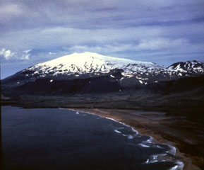
Snaefellsjokull
Iceland
64.8°N, 23.783°W; summit elev. 1446 m
All times are local (unless otherwise noted)
IMO reported that the Alert Level for Snaefellsjokull was raised from Gray (insufficient monitoring) to Green (normal, non-eruptive) on 12 November, reflecting the recent installation of three seismic stations along the peninsula. The new instruments will allow for better coverage and sensitivity for the detection of seismic unrest. The Alert Level scale consists of five colors.
Geological Summary. Ice-clad Snaefellsjökull volcano anchors the western tip of the isolated Snaefellsnes Peninsula in western Iceland. Numerous pyroclastic cones dot the flanks of this stratovolcano, the only large central volcano in this part of Iceland. Lower-flank craters produced basaltic lava flows and upper-flank craters intermediate-to-silicic material. Holocene lava flows extend to the sea over the entire western half of the volcano. Several Holocene silicic eruptions have originated from the summit crater. The latest dated eruption took place about 1750 years ago; several lava flows may be even younger.