Global Volcanism Program | Image GVP-07663

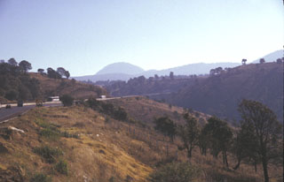
Papayo dome is seen in the center of this photo, a dacite lava dome along the crest of the Sierra Nevada 15 km north of Iztaccíhuatl volcano. The dome, seen here from the west, was the source of a voluminous postglacial lava flow that traveled 9.5 km to the WSW and more than 10 km to ENE. The Mexico City-Puebla highway (left) follows the northern margin of the lava flow, which covers an area of 84 km2.
Photo by Lee Siebert, 1997 (Smithsonian Institution).
![]() This image is made available under the Public Domain Dedication CC0 license, but proper attribution is appreciated.
This image is made available under the Public Domain Dedication CC0 license, but proper attribution is appreciated.
Keywords: lava dome
Papayo