Global Volcanism Program | Image GVP-11709

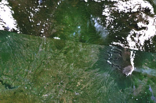
The Malang Plain, in the center of this NASA Landsat composite image (with north to the top) of eastern Java contains a group of nine ash cones, maars, and volcanic plugs. These volcanic centers lie in a broad valley between the Tengger caldera (upper right), Semeru volcano (lower right), and Kawi-Butak volcano, in the clouds at the upper left. Some of these may be partly parasitic to Tengger Caldera, although others have no clear connection to any specific eruption center and are situated on a distinct N-S zone of tectonic weakness.
NASA Landsat 7 image (worldwind.arc.nasa.gov)
![]() This image is made available as a Public Domain Work, but proper attribution is appreciated.
This image is made available as a Public Domain Work, but proper attribution is appreciated.
Malang Plain