Global Volcanism Program | Image GVP-12567

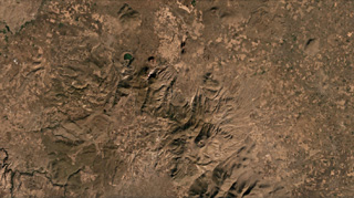
The Göllü Dag volcanic complex in Turkey is shown in this August 2019 Planet Labs satellite image monthly mosaic (N is at the top; this image is approximately 35 km across). The 10-12-km-wide complex formed through the coalescence of at least ten rhyolite domes, with scoria cones, lavas, ignimbrites, and over 25 vents surrounding them. The Aci Gölü maar contains the lake to the upper left, with several scoria cones nearby. The domes are in a rough southeast trend from this maar and have erosion gullies on their flanks.
Satellite image courtesy of Planet Labs Inc., 2020 (https://www.planet.com/).
Copyrighted image used with permission. All Rights Reserved. Contact photographer for any usage requests.
Derinkuyu Volcanic Complex