Recently Published Bulletin Reports
Manam (Papua New Guinea) Few ash plumes during November-December 2022
Krakatau (Indonesia) Strombolian activity and ash plumes during November 2022-April 2023
Stromboli (Italy) Strombolian explosions and lava flows continue during January-April 2023
Nishinoshima (Japan) Small ash plumes and fumarolic activity during November 2022 through April 2023
Karangetang (Indonesia) Lava flows, incandescent avalanches, and ash plumes during January-June 2023
Ahyi (United States) Intermittent hydroacoustic signals and discolored plumes during November 2022-June 2023
Kadovar (Papua New Guinea) An ash plume and weak thermal anomaly during May 2023
San Miguel (El Salvador) Small gas-and-ash explosions during March and May 2023
Semisopochnoi (United States) Occasional explosions, ash deposits, and gas-and-steam plumes during December 2022-May 2023
Ebeko (Russia) Continued explosions, ash plumes, and ashfall during October 2022-May 2023
Home Reef (Tonga) Discolored plumes continued during November 2022-April 2023
Ambae (Vanuatu) New lava flow, ash plumes, and sulfur dioxide plumes during February-May 2023
Manam (Papua New Guinea) — July 2023  Cite this Report
Manam
Papua New Guinea
4.08°S, 145.037°E; summit elev. 1807 m
All times are local (unless otherwise noted)
Few ash plumes during November-December 2022
Manam is a 10-km-wide island that consists of two active summit craters: the Main summit crater and the South summit crater and is located 13 km off the northern coast of mainland Papua New Guinea. Frequent mild-to-moderate eruptions have been recorded since 1616. The current eruption period began during June 2014 and has more recently been characterized by intermittent ash plumes and thermal activity (BGVN 47:11). This report updates activity that occurred from November 2022 through May 2023 based on information from the Darwin Volcanic Ash Advisory Center (VAAC) and various satellite data.
Ash plumes were reported during November and December 2022 by the Darwin VAAC. On 7 November an ash plume rose to 2.1 km altitude and drifted NE based on satellite images and weather models. On 14 November an ash plume rose to 2.1 km altitude and drifted W based on RVO webcam images. On 20 November ash plumes rose to 1.8 km altitude and drifted NW. On 26 December an ash plume rose to 3 km altitude and drifted S and SSE.
Intermittent sulfur dioxide plumes were detected using the TROPOMI instrument on the Sentinel-5P satellite, some of which exceeded at least two Dobson Units (DU) and drifted in different directions (figure 93). Occasional low-to-moderate power thermal anomalies were recorded by the MIROVA (Middle InfraRed Observation of Volcanic Activity) system; less than five anomalies were recorded each month during November 2022 through May 2023 (figure 94). Two thermal hotspots were detected by the MODVOLC thermal alerts system on 10 December 2022. On clear weather days, thermal activity was also captured in infrared satellite imagery in both the Main and South summit craters, accompanied by gas-and-steam emissions (figure 95).
Geologic Background. The 10-km-wide island of Manam, lying 13 km off the northern coast of mainland Papua New Guinea, is one of the country's most active volcanoes. Four large radial valleys extend from the unvegetated summit of the conical basaltic-andesitic stratovolcano to its lower flanks. These valleys channel lava flows and pyroclastic avalanches that have sometimes reached the coast. Five small satellitic centers are located near the island's shoreline on the northern, southern, and western sides. Two summit craters are present; both are active, although most observed eruptions have originated from the southern crater, concentrating eruptive products during much of the past century into the SE valley. Frequent eruptions, typically of mild-to-moderate scale, have been recorded since 1616. Occasional larger eruptions have produced pyroclastic flows and lava flows that reached flat-lying coastal areas and entered the sea, sometimes impacting populated areas.
Information Contacts: Rabaul Volcano Observatory (RVO), Geohazards Management Division, Department of Mineral Policy and Geohazards Management (DMPGM), PO Box 3386, Kokopo, East New Britain Province, Papua New Guinea; Darwin Volcanic Ash Advisory Centre (VAAC), Bureau of Meteorology, Northern Territory Regional Office, PO Box 40050, Casuarina, NT 0811, Australia (URL: http://www.bom.gov.au/info/vaac/); MIROVA (Middle InfraRed Observation of Volcanic Activity), a collaborative project between the Universities of Turin and Florence (Italy) supported by the Centre for Volcanic Risk of the Italian Civil Protection Department (URL: http://www.mirovaweb.it/); Hawai'i Institute of Geophysics and Planetology (HIGP) - MODVOLC Thermal Alerts System, School of Ocean and Earth Science and Technology (SOEST), Univ. of Hawai'i, 2525 Correa Road, Honolulu, HI 96822, USA (URL: http://modis.higp.hawaii.edu/); NASA Global Sulfur Dioxide Monitoring Page, Atmospheric Chemistry and Dynamics Laboratory, NASA Goddard Space Flight Center (NASA/GSFC), 8800 Greenbelt Road, Goddard, Maryland, USA (URL: https://so2.gsfc.nasa.gov/); Copernicus Browser, Copernicus Data Space Ecosystem, European Space Agency (URL: https://dataspace.copernicus.eu/browser/).
Krakatau (Indonesia) — July 2023 Cite this Report
Krakatau
Indonesia
6.1009°S, 105.4233°E; summit elev. 285 m
All times are local (unless otherwise noted)
Strombolian activity and ash plumes during November 2022-April 2023
Krakatau is located in the Sunda Strait between Java and Sumatra, Indonesia. Caldera collapse during the catastrophic 1883 eruption destroyed Danan and Perbuwatan cones and left only a remnant of Rakata. The post-collapse cone of Anak Krakatau (Child of Krakatau) was constructed within the 1883 caldera at a point between the former Danan and Perbuwatan cones; it has been the site of frequent eruptions since 1927. The current eruption period began in May 2021 and has recently consisted of explosions, ash plumes, and thermal activity (BGVN 47:11). This report covers activity during November 2022 through April 2023 based on information provided by the Indonesian Center for Volcanology and Geological Hazard Mitigation, referred to as Pusat Vulkanologi dan Mitigasi Bencana Geologi (PVMBG), MAGMA Indonesia, the Darwin Volcanic Ash Advisory Center (VAAC), and several sources of satellite data.
Activity was relatively low during November and December 2022. Daily white gas-and-steam plumes rose 25-100 m above the summit and drifted in different directions. Gray ash plumes rose 200 m above the summit and drifted NE at 1047 and at 2343 on 11 November. On 14 November at 0933 ash plumes rose 300 m above the summit and drifted E. An ash plume was reported at 0935 on 15 December that rose 100 m above the summit and drifted NE. An eruptive event at 1031 later that day generated an ash plume that rose 700 m above the summit and drifted NE. A gray ash plume at 1910 rose 100 m above the summit and drifted E. Incandescent material was ejected above the vent based on an image taken at 1936.
During January 2023 daily white gas-and-steam plumes rose 25-300 m above the summit and drifted in multiple directions. Gray-to-brown ash plumes were reported at 1638 on 3 January, at 1410 and 1509 on 4 January, and at 0013 on 5 January that rose 100-750 m above the summit and drifted NE and E; the gray-to-black ash plume at 1509 on 4 January rose as high as 3 km above the summit and drifted E. Gray ash plumes were recorded at 1754, 2241, and 2325 on 11 January and at 0046 on 12 January and rose 200-300 m above the summit and drifted NE. Toward the end of January, PVMBG reported that activity had intensified; Strombolian activity was visible in webcam images taken at 0041, 0043, and 0450 on 23 January. Multiple gray ash plumes throughout the day rose 200-500 m above the summit and drifted E and SE (figure 135). Webcam images showed progressively intensifying Strombolian activity at 1919, 1958, and 2113 on 24 January; a gray ash plume at 1957 rose 300 m above the summit and drifted E (figure 135). Eruptive events at 0231 and 2256 on 25 January and at 0003 on 26 January ejected incandescent material from the vent, based on webcam images. Gray ash plumes observed during 26-27 January rose 300-500 m above the summit and drifted NE, E, and SE.
Low levels of activity were reported during February and March. Daily white gas-and-steam plumes rose 25-300 m above the summit and drifted in different directions. The Darwin VAAC reported that continuous ash emissions rose to 1.5-1.8 km altitude and drifted W and NW during 1240-1300 on 10 March, based on satellite images, weather models, and PVMBG webcams. White-and-gray ash plumes rose 500 m and 300 m above the summit and drifted SW at 1446 and 1846 on 18 March, respectively. An eruptive event was recorded at 2143, though it was not visible due to darkness. Multiple ash plumes were reported during 27-29 March that rose as high as 2.5 km above the summit and drifted NE, W, and SW (figure 136). Webcam images captured incandescent ejecta above the vent at 0415 and around the summit area at 2003 on 28 March and at 0047 above the vent on 29 March.
Daily white gas-and-steam plumes rose 25-300 m above the summit and drifted in multiple directions during April and May. White-and-gray and black plumes rose 50-300 m above the summit on 2 and 9 April. On 11 May at 1241 a gray ash plume rose 1-3 km above the summit and drifted SW. On 12 May at 0920 a gray ash plume rose 2.5 km above the summit and drifted SW and at 2320 an ash plume rose 1.5 km above the summit and drifted SW. An accompanying webcam image showed incandescent ejecta. On 13 May at 0710 a gray ash plume rose 2 km above the summit and drifted SW (figure 137).
The MIROVA (Middle InfraRed Observation of Volcanic Activity) graph of MODIS thermal anomaly data showed intermittent low-to-moderate power thermal anomalies during November 2022 through April 2023 (figure 138). Some of this thermal activity was also visible in infrared satellite imagery at the crater, accompanied by gas-and-steam and ash plumes that drifted in different directions (figure 139).
Geologic Background. The renowned Krakatau (frequently mis-named as Krakatoa) volcano lies in the Sunda Strait between Java and Sumatra. Collapse of an older edifice, perhaps in 416 or 535 CE, formed a 7-km-wide caldera. Remnants of that volcano are preserved in Verlaten and Lang Islands; subsequently the Rakata, Danan, and Perbuwatan cones were formed, coalescing to create the pre-1883 Krakatau Island. Caldera collapse during the catastrophic 1883 eruption destroyed Danan and Perbuwatan, and left only a remnant of Rakata. This eruption caused more than 36,000 fatalities, most as a result of tsunamis that swept the adjacent coastlines of Sumatra and Java. Pyroclastic surges traveled 40 km across the Sunda Strait and reached the Sumatra coast. After a quiescence of less than a half century, the post-collapse cone of Anak Krakatau (Child of Krakatau) was constructed within the 1883 caldera at a point between the former Danan and Perbuwatan cones. Anak Krakatau has been the site of frequent eruptions since 1927.
Information Contacts: Pusat Vulkanologi dan Mitigasi Bencana Geologi (PVMBG, also known as Indonesian Center for Volcanology and Geological Hazard Mitigation, CVGHM), Jalan Diponegoro 57, Bandung 40122, Indonesia (URL: http://www.vsi.esdm.go.id/); MAGMA Indonesia, Kementerian Energi dan Sumber Daya Mineral (URL: https://magma.esdm.go.id/v1); Darwin Volcanic Ash Advisory Centre (VAAC), Bureau of Meteorology, Northern Territory Regional Office, PO Box 40050, Casuarina, NT 0811, Australia (URL: http://www.bom.gov.au/info/vaac/); MIROVA (Middle InfraRed Observation of Volcanic Activity), a collaborative project between the Universities of Turin and Florence (Italy) supported by the Centre for Volcanic Risk of the Italian Civil Protection Department (URL: http://www.mirovaweb.it/); Copernicus Browser, Copernicus Data Space Ecosystem, European Space Agency (URL: https://dataspace.copernicus.eu/browser/).
Stromboli
Italy
38.789°N, 15.213°E; summit elev. 924 m
All times are local (unless otherwise noted)
Strombolian explosions and lava flows continue during January-April 2023
Stromboli, located in Italy, has exhibited nearly constant lava fountains for the past 2,000 years; recorded eruptions date back to 350 BCE. Eruptive activity occurs at the summit from multiple vents, which include a north crater area (N area) and a central-southern crater (CS area) on a terrace known as the ‘terrazza craterica’ at the head of the Sciara del Fuoco, a large scarp that runs from the summit down the NW side of the volcano-island. Activity typically consists of Strombolian explosions, incandescent ejecta, lava flows, and pyroclastic flows. Thermal and visual monitoring cameras are located on the nearby Pizzo Sopra La Fossa, above the terrazza craterica, and at multiple flank locations. The current eruption period has been ongoing since 1934 and recent activity has consisted of frequent Strombolian explosions and lava flows (BGVN 48:02). This report updates activity during January through April 2023 primarily characterized by Strombolian explosions and lava flows based on reports from Italy's Istituto Nazionale di Geofisica e Vulcanologia (INGV) and various satellite data.
Frequent explosive activity continued throughout the reporting period, generally in the low-to-medium range, based on the number of hourly explosions in the summit crater (figure 253, table 16). Intermittent thermal activity was recorded by the MIROVA (Middle InfraRed Observation of Volcanic Activity) analysis of MODIS satellite data (figure 254). According to data collected by the MODVOLC thermal algorithm, a total of 9 thermal alerts were detected: one on 2 January 2023, one on 1 February, five on 24 March, and two on 26 March. The stronger pulses of thermal activity likely reflected lava flow events. Infrared satellite imagery captured relatively strong thermal hotspots at the two active summit craters on clear weather days, showing an especially strong event on 8 March (figure 255).
Table 16. Summary of type, frequency, and intensity of explosive activity at Stromboli by month during January-April 2023; information from webcam observations. Courtesy of INGV weekly reports.
| Month |
Explosive Activity |
| Jan 2023 |
Typical Strombolian activity with spattering and lava overflows in the N crater area. Explosions were reported from 4 vents in the N area and 1-2 vents in the CS area. The average hourly frequency of explosions was low-to-medium (1-12 events/hour). The intensity of the explosions varied from low (less than 80 m high) to medium (less than 150 m high) in the N crater area and up to high (greater than 150 m high) in the CS crater area. |
| Feb 2023 |
Typical Strombolian activity with spattering in the N crater area. Explosions were reported from 2-3 vents in the N area and 1-4 vents in the CS area. The average hourly frequency of explosions was low-to-medium (1-14 events/hour). The intensity of the explosions varied from low (less than 80 m high) to medium (less than 150 m high) in the N crater area and up to high (greater than 150 m high) in the CS crater area. |
| Mar 2023 |
Typical Strombolian activity with spattering and lava overflows in the N crater area. Explosions were reported from 2-3 vents in the N area and 2-4 vents in the CS area. The average hourly frequency of explosions was low-to-medium (1-18 events/hour). The intensity of the explosions varied from low (less than 80 m high) to medium (less than 150 m high) in the N crater area and up to high (greater than 150 m high) in the CS crater area. |
| Apr 2023 |
Typical Strombolian activity. Explosions were reported from 2 vents in the N area and 2-3 vents in the CS area. The average hourly frequency of explosions was low-to-high (1-16 events/hour). The intensity of the explosions varied from low (less than 80 m high) to medium (less than 150 m high) in both the N and CS crater areas. |
Activity during January-February 2023. Strombolian explosions were reported in the N crater area, as well as lava effusion. Explosive activity in the N crater area ejected coarse material (bombs and lapilli). Intense spattering was observed in both the N1 and N2 craters. In the CS crater area, explosions generally ejected fine material (ash), sometimes to heights greater than 250 m. The intensity of the explosions was characterized as low-to-medium in the N crater and medium-to-high in the CS crater. After intense spattering activity from the N crater area, a lava overflow began at 2136 on 2 January that flowed part way down the Sciara del Fuoco, possibly moving down the drainage that formed in October, out of view from webcams. The flow remained active for a couple of hours before stopping and beginning to cool. A second lava flow was reported at 0224 on 4 January that similarly remained active for a few hours before stopping and cooling. Intense spattering was observed on 11 and 13 January from the N1 crater. After intense spattering activity at the N2 crater at 1052 on 17 January another lava flow started to flow into the upper part of the Sciara del Fuoco (figure 256), dividing into two: one that traveled in the direction of the drainage formed in October, and the other one moving parallel to the point of emission. By the afternoon, the rate of the flow began to decrease, and at 1900 it started to cool. A lava flow was reported at 1519 on 24 January following intense spattering in the N2 area, which began to flow into the upper part of the Sciara del Fuoco. By the morning of 25 January, the lava flow had begun to cool. During 27 January the frequency of eruption in the CS crater area increased to 6-7 events/hour compared to the typical 1-7 events/hour; the following two days showed a decrease in frequency to less than 1 event/hour. Starting at 1007 on 30 January a high-energy explosive sequence was produced by vents in the CS crater area. The sequence began with an initial energetic pulse that lasted 45 seconds, ejecting predominantly coarse products 300 m above the crater that fell in an ESE direction. Subsequent and less intense explosions ejected material 100 m above the crater. The total duration of this event lasted approximately two minutes. During 31 January through 6, 13, and 24 February spattering activity was particularly intense for short periods in the N2 crater.
An explosive sequence was reported on 16 February that was characterized by a major explosion in the CS crater area (figure 257). The sequence began at 1817 near the S2 crater that ejected material radially. A few seconds later, lava fountains were observed in the central part of the crater. Three explosions of medium intensity (material was ejected less than 150 m high) were recorded at the S2 crater. The first part of this sequence lasted approximately one minute, according to INGV, and material rose 300 m above the crater and then was deposited along the Sciara del Fuoco. The second phase began at 1818 at the S1 crater; it lasted seven seconds and material was ejected 150 m above the crater. Another event 20 seconds later lasted 12 seconds, also ejecting material 150 m above the crater. The sequence ended with at least three explosions of mostly fine material from the S1 crater. The total duration of this sequence was about two minutes.
Short, intense spattering activity was noted above the N1 crater on 27 and 28 February. A lava overflow was first reported at 0657 from the N2 crater on 27 February that flowed into the October 2022 drainage. By 1900 the flow had stopped. A second lava overflow also in the N crater area occurred at 2149, which overlapped the first flow and then stopped by 0150 on 28 February. Material detached from both the lava overflows rolled down the Sciara del Fuoco, some of which was visible in webcam images.
Activity during March-April 2023. Strombolian activity continued with spattering activity and lava overflows in the N crater area during March. Explosive activity at the N crater area varied from low (less than 80 m high) to medium (less than 150 m high) and ejected coarse material, such as bombs and lapilli. Spattering was observed above the N1 crater, while explosive activity at the CS crater area varied from medium to high (greater than 150 m high) and ejected coarse material. Intense spattering activity was observed for short periods on 6 March above the N1 crater. At approximately 0610 a lava overflow was reported around the N2 crater on 8 March, which then flowed into the October 2022 drainage. By 1700 the flow started to cool. A second overflow began at 1712 on 9 March and overlapped the previous flow. It had stopped by 2100. Material from both flows was deposited along the Sciara del Fuoco, though much of the activity was not visible in webcam images. On 11 March a lava overflow was observed at 0215 that overlapped the two previous flows in the October 2022 drainage. By late afternoon on 12 March, it had stopped.
During a field excursion on 16 March, scientists noted that a vent in the central crater area was degassing. Another vent showed occasional Strombolian activity that emitted ash and lapilli. During 1200-1430 low-to-medium intense activity was reported; the N1 crater emitted ash emissions and the N2 crater emitted both ash and coarse material. Some explosions also occurred in the CS crater area that ejected coarse material. The C crater in the CS crater area occasionally showed gas jetting and low intensity explosions on 17 and 22 March; no activity was observed at the S1 crater. Intense, longer periods of spattering were reported in the N1 crater on 19, 24, and 25 March. Around 2242 on 23 March a lava overflow began from the N1 crater that, after about an hour, began moving down the October 2022 drainage and flow along the Sciara del Fuoco (figure 258). Between 0200 and 0400 on 26 March the flow rate increased, which generated avalanches of material from collapses at the advancing flow front. By early afternoon, the flow began to cool. On 25 March at 1548 an explosive sequence began from one of the vents at S2 in the CS crater area (figure 258). Fine ash mixed with coarse material was ejected 300 m above the crater rim and drifted SSE. Some modest explosions around Vent C were detected at 1549 on 25 March, which included an explosion at 1551 that ejected coarse material. The entire explosive sequence lasted approximately three minutes.
During April explosions persisted in both the N and CS crater areas. Fine material was ejected less than 80 m above the N crater rim until 6 April, followed by ejection of coarser material. Fine material was also ejected less than 80 m above the CS crater rim. The C and S2 crater did not show significant eruptive activity. On 7 April an explosive sequence was detected in the CS crater area at 1203 (figure 259). The first explosion lasted approximately 18 seconds and ejected material 400 m above the crater rim, depositing pyroclastic material in the upper part of the Sciara del Fuoco. At 1204 a second, less intense explosion lasted approximately four seconds and deposited pyroclastic products outside the crater area and near Pizzo Sopra La Fossa. A third explosion at 1205 was mainly composed of ash that rose about 150 m above the crater and lasted roughly 20 seconds. A fourth explosion occurred at 1205 about 28 seconds after the third explosion and ejected a mixture of coarse and fine material about 200 m above the crater; the explosion lasted roughly seven seconds. Overall, the entire explosive sequence lasted about two minutes and 20 seconds. After the explosive sequence on 7 April, explosions in both the N and CS crater areas ejected material as high as 150 m above the crater.
On 21 April research scientists from INGV made field observations in the summit area of Stromboli, and some lapilli samples were collected. In the N crater area near the N1 crater, a small cone was observed with at least two active vents, one of which was characterized by Strombolian explosions. The other vent produced explosions that ejected ash and chunks of cooled lava. At the N2 crater at least one vent was active and frequently emitted ash. In the CS crater area, a small cone contained 2-3 degassing vents and a smaller, possible fissure area also showed signs of degassing close to the Pizzo Sopra La Fossa. In the S part of the crater, three vents were active: a small hornito was characterized by modest and rare explosions, a vent that intermittently produced weak Strombolian explosions, and a vent at the end of the terrace that produced frequent ash emissions. Near the S1 crater there was a hornito that generally emitted weak gas-and-steam emissions, sometimes associated with “gas rings”. On 22 April another field inspection was carried out that reported two large sliding surfaces on the Sciara del Fuoco that showed where blocks frequently descended toward the sea. A thermal anomaly was detected at 0150 on 29 April.
Geologic Background. Spectacular incandescent nighttime explosions at Stromboli have long attracted visitors to the "Lighthouse of the Mediterranean" in the NE Aeolian Islands. This volcano has lent its name to the frequent mild explosive activity that has characterized its eruptions throughout much of historical time. The small island is the emergent summit of a volcano that grew in two main eruptive cycles, the last of which formed the western portion of the island. The Neostromboli eruptive period took place between about 13,000 and 5,000 years ago. The active summit vents are located at the head of the Sciara del Fuoco, a prominent scarp that formed about 5,000 years ago due to a series of slope failures which extends to below sea level. The modern volcano has been constructed within this scarp, which funnels pyroclastic ejecta and lava flows to the NW. Essentially continuous mild Strombolian explosions, sometimes accompanied by lava flows, have been recorded for more than a millennium.
Information Contacts: Istituto Nazionale di Geofisica e Vulcanologia (INGV), Sezione di Catania, Piazza Roma 2, 95123 Catania, Italy, (URL: http://www.ct.ingv.it/en/); MIROVA (Middle InfraRed Observation of Volcanic Activity), a collaborative project between the Universities of Turin and Florence (Italy) supported by the Centre for Volcanic Risk of the Italian Civil Protection Department (URL: http://www.mirovaweb.it/); Hawai'i Institute of Geophysics and Planetology (HIGP) - MODVOLC Thermal Alerts System, School of Ocean and Earth Science and Technology (SOEST), Univ. of Hawai'i, 2525 Correa Road, Honolulu, HI 96822, USA (URL: http://modis.higp.hawaii.edu/); Copernicus Browser, Copernicus Data Space Ecosystem, European Space Agency (URL: https://dataspace.copernicus.eu/browser/).
Nishinoshima (Japan) — July 2023 Cite this Report
Nishinoshima
Japan
27.247°N, 140.874°E; summit elev. 100 m
All times are local (unless otherwise noted)
Small ash plumes and fumarolic activity during November 2022 through April 2023
Nishinoshima is a small island located about 1,000 km S of Tokyo in the Ogasawara Arc in Japan. The island is the summit of a massive submarine volcano that has prominent peaks to the S, W, and NE. Eruptions date back to 1973; the most recent eruption period began in October 2022 and was characterized by ash plumes and fumarolic activity (BGVN 47:12). This report describes ash plumes and fumarolic activity during November 2022 through April 2023 based on monthly reports from the Japan Meteorological Agency (JMA) monthly reports and satellite data.
The most recent eruptive activity prior to the reporting internal occurred on 12 October 2022, when an ash plume rose 3.5 km above the crater rim. An aerial observation conducted by the Japan Coast Guard (JCG) on 25 November reported that white fumaroles rose approximately 200 m above the central crater of a pyroclastic cone (figure 119), and multiple plumes were observed on the ESE flank of the cone. Discolored water ranging from reddish-brown to brown and yellowish-green were visible around the perimeter of the island (figure 119). No significant activity was reported in December.
During an overflight conducted by JCG on 25 January 2023 intermittent activity and small, blackish-gray plumes rose 900 m above the central part of the crater were observed (figure 120). The fumarolic zone of the E flank and base of the cone had expanded and emissions had intensified. Dark brown discolored water was visible around the perimeter of the island.
No significant activity was reported during February through March. Ash plumes at 1050 and 1420 on 11 April rose 1.9 km above the crater rim and drifted NW and N. These were the first ash plumes observed since 12 October 2022. On 14 April JCG carried out an overflight and reported that no further eruptive activity was visible, although white gas-and-steam plumes were visible from the central crater and rose 900 m high (figure 121). Brownish and yellow-green discolored water surrounded the island.
Intermittent low-to-moderate power thermal anomalies were recorded in the MIROVA graph (Middle InfraRed Observation of Volcanic Activity) during November 2022 through April 2023 (figure 123). A cluster of six to eight anomalies were detected during November while a smaller number were detected during the following months: two to three during December, one during mid-January 2023, one during February, five during March, and two during April. Thermal activity was also reflected in infrared satellite data at the summit crater, accompanied by occasional gas-and-steam plumes (figure 124).
Geologic Background. The small island of Nishinoshima was enlarged when several new islands coalesced during an eruption in 1973-74. Multiple eruptions that began in 2013 completely covered the previous exposed surface and continued to enlarge the island. The island is the summit of a massive submarine volcano that has prominent peaks to the S, W, and NE. The summit of the southern cone rises to within 214 m of the ocean surface 9 km SSE.
Information Contacts: Japan Meteorological Agency (JMA), 1-3-4 Otemachi, Chiyoda-ku, Tokyo 100-8122, Japan (URL: http://www.jma.go.jp/jma/indexe.html); MIROVA (Middle InfraRed Observation of Volcanic Activity), a collaborative project between the Universities of Turin and Florence (Italy) supported by the Centre for Volcanic Risk of the Italian Civil Protection Department (URL: http://www.mirovaweb.it/); Copernicus Browser, Copernicus Data Space Ecosystem, European Space Agency (URL: https://dataspace.copernicus.eu/browser/).
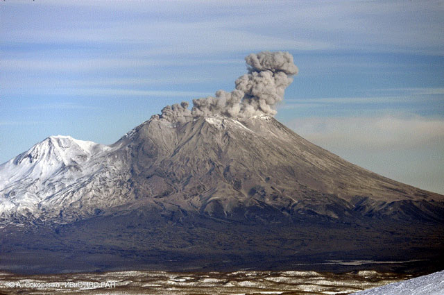
Karangetang (Indonesia) — July 2023 Cite this Report
Karangetang
Indonesia
2.781°N, 125.407°E; summit elev. 1797 m
All times are local (unless otherwise noted)
Lava flows, incandescent avalanches, and ash plumes during January-June 2023
Karangetang (also known as Api Siau), at the northern end of the island of Siau, Indonesia, contains five summit craters along a N-S line. More than 40 eruptions have been recorded since 1675; recent eruptions have included frequent explosive activity, sometimes accompanied by pyroclastic flows and lahars. Lava dome growth has occurred in the summit craters and collapses of lava flow fronts have produced pyroclastic flows. The two active summit craters are Kawah Dua (the N crater) and Kawah Utama (the S crater, also referred to as the “Main Crater”). The most recent eruption began in late November 2018 and has more recently consisted of weak thermal activity and gas-and-steam emissions (BGVN 48:01). This report updates activity characterized by lava flows, incandescent avalanches, and ash plumes during January through June 2023 using reports from Pusat Vulkanologi dan Mitigasi Bencana Geologi (PVMBG, also known as CVGHM, or the Center of Volcanology and Geological Hazard Mitigation), MAGMA Indonesia, the Darwin VAAC (Volcano Ash Advisory Center), and satellite data.
Activity during January was relatively low and mainly consisted of white gas-and-steam emissions that rose 25-150 m above Main Crater (S crater) and drifted in different directions. Incandescence was visible from the lava dome in Kawah Dua (the N crater). Weather conditions often prevented clear views of the summit. On 18 January the number of seismic signals that indicated avalanches of material began to increase. In addition, there were a total of 71 earthquakes detected during the month.
Activity continued to increase during the first week of February. Material from Main Crater traveled as far as 800 m down the Batuawang (S) and Batang (W) drainages and as far as 1 km W down the Beha (W) drainage on 4 February. On 6 February 43 earthquake events were recorded, and on 7 February, 62 events were recorded. White gas-and-steam emissions rose 25-250 m above both summit craters throughout the month. PVMBG reported an eruption began during the evening of 8 February around 1700. Photos showed incandescent material at Main Crater. Incandescent material had also descended the flank in at least two unconfirmed directions as far as 2 km from Main Crater, accompanied by ash plumes (figure 60). As a result, PVMBG increased the Volcano Alert Level (VAL) to 3 (the second highest level on a 1-4 scale).
Occasional nighttime webcam images showed three main incandescent lava flows of differing lengths traveling down the S, SW, and W flanks (figure 61). Incandescent rocks were visible on the upper flanks, possibly from ejected or collapsed material from the crater, and incandescence was the most intense at the summit. Based on analyses of satellite imagery and weather models, the Darwin VAAC reported that daily ash plumes during 16-20 February rose to 2.1-3 km altitude and drifted NNE, E, and SE. BNPB reported on 16 February that as many as 77 people were evacuated and relocated to the East Siau Museum. A webcam image taken at 2156 on 17 February possibly showed incandescent material descending the SE flank. Ash plumes rose to 2.1 km altitude and drifted SE during 22-23 February, according to the Darwin VAAC.
Incandescent avalanches of material and summit incandescence at Main Crater continued during March. White gas-and-steam emissions during March generally rose 25-150 m above the summit crater; on 31 March gas-and-steam emissions rose 200-400 m high. An ash plume rose to 2.4 km altitude and drifted S at 1710 on 9 March and a large thermal anomaly was visible in images taken at 0550 and 0930 on 10 March. Incandescent material was visible at the summit and on the flanks based on webcam images taken at 0007 and 2345 on 16 March, at 1828 on 17 March, at 1940 on 18 March, at 2311 on 19 March, and at 2351 on 20 March. Incandescence was most intense on 18 and 20 March and webcam images showed possible Strombolian explosions (figure 62). An ash plume rose to 2.4 km altitude and drifted SW on 18 March, accompanied by a thermal anomaly.
Summit crater incandescence at Main Crater and on the flanks persisted during April. Incandescent material at the S crater and on the flanks was reported at 0016 on 1 April. The lava flows had stopped by 1 April according to PVMBG, although incandescence was still visible up to 10 m high. Seismic signals indicating effusion decreased and by 6 April they were no longer detected. Incandescence was visible from both summit craters. On 26 April the VAL was lowered to 2 (the second lowest level on a 1-4 scale). White gas-and-steam emissions rose 25-200 m above the summit crater.
During May white gas-and-steam emissions generally rose 50-250 m above the summit, though it was often cloudy, which prevented clear views; on 21 May gas-and-steam emissions rose 50-400 m high. Nighttime N summit crater incandescence rose 10-25 m above the lava dome, and less intense incandescence was noted above Main Crater, which reached about 10 m above the dome. Sounds of falling rocks at Main Crater were heard on 15 May and the seismic network recorded 32 rockfall events in the crater on 17 May. Avalanches traveled as far as 1.5 km down the SW and S flanks, accompanied by rumbling sounds on 18 May. Incandescent material descending the flanks was captured in a webcam image at 2025 on 19 May (figure 63) and on 29 May; summit crater incandescence was observed in webcam images at 2332 on 26 May and at 2304 on 29 May. On 19 May the VAL was again raised to 3.
Occasional Main Crater incandescence was reported during June, as well as incandescent material on the flanks. White gas-and-steam emissions rose 10-200 m above the summit crater. Ash plumes rose to 2.1 km altitude and drifted SE and E during 2-4 June, according to the Darwin VAAC. Material on the flanks of Main Crater were observed at 2225 on 7 June, at 2051 on 9 June, at 0007 on 17 June, and at 0440 on 18 June. Webcam images taken on 21, 25, and 27 June showed incandescence at Main Crater and from material on the flanks.
MIROVA (Middle InfraRed Observation of Volcanic Activity) analysis of MODIS satellite data showed strong thermal activity during mid-February through March and mid-May through June, which represented incandescent avalanches and lava flows (figure 64). During April through mid-May the power of the anomalies decreased but frequent anomalies were still detected. Brief gaps in activity occurred during late March through early April and during mid-June. Infrared satellite images showed strong lava flows mainly affecting the SW and S flanks, accompanied by gas-and-steam emissions (figure 65). According to data recorded by the MODVOLC thermal algorithm, there were a total of 79 thermal hotspots detected: 28 during February, 24 during March, one during April, five during May, and 21 during June.
Geologic Background. Karangetang (Api Siau) volcano lies at the northern end of the island of Siau, about 125 km NNE of the NE-most point of Sulawesi. The stratovolcano contains five summit craters along a N-S line. It is one of Indonesia's most active volcanoes, with more than 40 eruptions recorded since 1675 and many additional small eruptions that were not documented (Neumann van Padang, 1951). Twentieth-century eruptions have included frequent explosive activity sometimes accompanied by pyroclastic flows and lahars. Lava dome growth has occurred in the summit craters; collapse of lava flow fronts have produced pyroclastic flows.
Information Contacts: Pusat Vulkanologi dan Mitigasi Bencana Geologi (PVMBG, also known as Indonesian Center for Volcanology and Geological Hazard Mitigation, CVGHM), Jalan Diponegoro 57, Bandung 40122, Indonesia (URL: http://www.vsi.esdm.go.id/); MAGMA Indonesia, Kementerian Energi dan Sumber Daya Mineral (URL: https://magma.esdm.go.id/v1); Badan Nasional Penanggulangan Bencana (BNPB), National Disaster Management Agency, Graha BNPB - Jl. Scout Kav.38, East Jakarta 13120, Indonesia (URL: http://www.bnpb.go.id/); Darwin Volcanic Ash Advisory Centre (VAAC), Bureau of Meteorology, Northern Territory Regional Office, PO Box 40050, Casuarina, NT 0811, Australia (URL: http://www.bom.gov.au/info/vaac/); MIROVA (Middle InfraRed Observation of Volcanic Activity), a collaborative project between the Universities of Turin and Florence (Italy) supported by the Centre for Volcanic Risk of the Italian Civil Protection Department (URL: http://www.mirovaweb.it/); Hawai'i Institute of Geophysics and Planetology (HIGP) - MODVOLC Thermal Alerts System, School of Ocean and Earth Science and Technology (SOEST), Univ. of Hawai'i, 2525 Correa Road, Honolulu, HI 96822, USA (URL: http://modis.higp.hawaii.edu/); Copernicus Browser, Copernicus Data Space Ecosystem, European Space Agency (URL: https://dataspace.copernicus.eu/browser/); IDN Times, Jl. Jend. Gatot Subroto Kav. 27 3rd Floor Kuningan, Jakarta, Indonesia 12950, Status of Karangetang Volcano in Sitaro Islands Increases (URL: https://sulsel.idntimes.com/news/indonesia/savi/status-gunung-api-karangetang-di-kepulauan-sitaro-meningkat?page=all).
Ahyi (United States) — July 2023 Cite this Report
Ahyi
United States
20.42°N, 145.03°E; summit elev. -75 m
All times are local (unless otherwise noted)
Intermittent hydroacoustic signals and discolored plumes during November 2022-June 2023
Ahyi seamount is a large, conical submarine volcano that rises to within 75 m of the ocean surface about 18 km SE of the island of Farallon de Pajaros in the Northern Marianas. The remote location of the seamount has made eruptions difficult to document, but seismic stations installed in the region confirmed an eruption in the vicinity in 2001. No new activity was detected until April-May 2014 when an eruption was detected by NOAA (National Oceanic and Atmospheric Administration) divers, hydroacoustic sensors, and seismic stations (BGVN 42:04). New activity was first detected on 15 November by hydroacoustic sensors that were consistent with submarine volcanic activity. This report covers activity during November 2022 through June 2023 based on daily and weekly reports from the US Geological Survey.
Starting in mid-October, hydroacoustic sensors at Wake Island (2.2 km E) recorded signals consistent with submarine volcanic activity, according to a report from the USGS issued on 15 November 2022. A combined analysis of the hydroacoustic signals and seismic stations located at Guam and Chichijima Island, Japan, suggested that the source of this activity was at or near the Ahyi seamount. After a re-analysis of a satellite image of the area that was captured on 6 November, USGS confirmed that there was no evidence of discoloration at the ocean surface. Few hydroacoustic and seismic signals continued through November, including on 18 November, which USGS suggested signified a decline or pause in unrest. A VONA (Volcano Observatory Notice for Aviation) reported that a discolored water plume was persistently visible in satellite data starting on 18 November (figure 6). Though clouds often obscured clear views of the volcano, another discolored water plume was captured in a satellite image on 26 November. The Aviation Color Code (ACC) was raised to Yellow (the second lowest level on a four-color scale) and the Volcano Alert Level (VAL) was raised to Advisory (the second lowest level on a four-level scale) on 29 November.
During December, occasional detections were recorded on the Wake Island hydrophone sensors and discolored water over the seamount remained visible. During 2-7, 10-12, and 16-31 December possible explosion signals were detected. A small area of discolored water was observed in high-resolution Sentinel-2 satellite images during 1-6 December (figure 7). High-resolution satellite images recorded discolored water plumes on 13 December that originated from the summit region; no observations indicated that activity breached the ocean surface. A possible underwater plume was visible in satellite images on 18 December, and during 19-20 December a definite but diffuse underwater plume located SSE from the main vent was reported. An underwater plume was visible in a satellite image taken on 26 December (figure 7).
Hydrophone sensors continued to detect signals consistent with possible explosions during 1-8 January 2023. USGS reported that the number of detections decreased during 4-5 January. The hydrophone sensors experienced a data outage that started at 0118 on 8 January and continued through 10 January, though according to USGS, possible explosions were recorded prior to the data outage and likely continued during the outage. A discolored water plume originating from the summit region was detected in a partly cloudy satellite image on 8 January. On 11-12 and 15-17 January possible explosion signals were recorded again. One small signal was detected during 22-23 January and several signals were recorded on 25 and 31 January. During 27-31 January a plume of discolored water was observed above the seamount in satellite imagery (figure 8).
Low levels of activity continued during February and March, based on data from pressure sensors on Wake Island. During 1 and 4-6 February activity was reported, and a submarine plume was observed on 4 February (figure 8). Possible explosion signals were detected during 7-8, 10, 13-14, and 24 February. During 1-2 and 3-5 March a plume of discolored water was observed in satellite imagery (figure 8). Almost continuous hydroacoustic signals were detected in remote pressure sensor data on Wake Island 2,270 km E from the volcano during 7-13 March. During 12-13 March water discoloration around the seamount was observed in satellite imagery, despite cloudy weather. By 14 March discolored water extended about 35 km, but no direction was noted. USGS reported that the continuous hydroacoustic signals detected during 13-14 March stopped abruptly on 14 March and no new detections were observed. Three 30 second hydroacoustic detections were reported during 17-19 March, but no activity was visible due to cloudy weather. A data outage was reported during 21-22 March, making pressure sensor data unavailable; a discolored water plume was, however, visible in satellite data. A possible underwater explosion signal was detected by pressure sensors at Wake Island on 26, 29, and 31 March, though the cause and origin of these events were unclear.
Similar low activity continued during April, May, and June. Several signals were detected during 1-3 April in pressure sensors at Wake Island. USGS suggested that these may be related to underwater explosions or earthquakes at the volcano, but no underwater plumes were visible in clear satellite images. The pressure sensors had data outages during 12-13 April and no data were recorded; no underwater plumes were visible in satellite images, although cloudy weather obscured most clear views. Eruptive activity was reported starting at 2210 on 21 May. On 22 May a discolored water plume that extended 4 km was visible in satellite images, though no direction was recorded. During 23-24 May some signals were detected by the underwater pressure sensors. Possible hydroacoustic signals were detected during 2-3 and 6-8 June. Multiple hydroacoustic signals were detected during 9-11 and 16-17 June, although no activity was visible in satellite images. One hydroacoustic signal was detected during 23-24 June, but there was some uncertainty about its association with volcanic activity. A single possible hydroacoustic signal was detected during 30 June to 1 July.
Geologic Background. Ahyi seamount is a large conical submarine volcano that rises to within 75 m of the ocean surface ~18 km SE of the island of Farallon de Pajaros in the northern Marianas. Water discoloration has been observed there, and in 1979 the crew of a fishing boat felt shocks over the summit area, followed by upwelling of sulfur-bearing water. On 24-25 April 2001 an explosive eruption was detected seismically by a station on Rangiroa Atoll, Tuamotu Archipelago. The event was well constrained (+/- 15 km) at a location near the southern base of Ahyi. An eruption in April-May 2014 was detected by NOAA divers, hydroacoustic sensors, and seismic stations.
Information Contacts: US Geological Survey, Volcano Hazards Program (USGS-VHP), 12201 Sunrise Valley Drive, Reston, VA, USA, https://volcanoes.usgs.gov/index.html; Copernicus Browser, Copernicus Data Space Ecosystem, European Space Agency (URL: https://dataspace.copernicus.eu/browser/).
Kadovar (Papua New Guinea) — June 2023 Cite this Report
Kadovar
Papua New Guinea
3.608°S, 144.588°E; summit elev. 365 m
All times are local (unless otherwise noted)
An ash plume and weak thermal anomaly during May 2023
Kadovar is a 2-km-wide island that is the emergent summit of a Bismarck Sea stratovolcano. It lies off the coast of New Guinea, about 25 km N of the mouth of the Sepik River. Prior to an eruption that began in 2018, a lava dome formed the high point of the volcano, filling an arcuate landslide scarp open to the S. Submarine debris-avalanche deposits occur to the S of the island. The current eruption began in January 2018 and has comprised lava effusion from vents at the summit and at the E coast; more recent activity has consisted of ash plumes, weak thermal activity, and gas-and-steam plumes (BGVN 48:02). This report covers activity during February through May 2023 using information from the Darwin Volcanic Ash Advisory Center (VAAC) and satellite data.
Activity during the reporting period was relatively low and mainly consisted of white gas-and-steam plumes that were visible in natural color satellite images on clear weather days (figure 67). According to a Darwin VAAC report, at 2040 on 6 May an ash plume rose to 4.6 km altitude and drifted W; by 2300 the plume had dissipated. MODIS satellite instruments using the MODVOLC thermal algorithm detected a single thermal hotspot on the SE side of the island on 7 May. Weak thermal activity was also detected in a satellite image on the E side of the island on 14 May, accompanied by a white gas-and-steam plume that drifted SE (figure 68).
Geologic Background. The 2-km-wide island of Kadovar is the emergent summit of a Bismarck Sea stratovolcano of Holocene age. It is part of the Schouten Islands, and lies off the coast of New Guinea, about 25 km N of the mouth of the Sepik River. Prior to an eruption that began in 2018, a lava dome formed the high point of the andesitic volcano, filling an arcuate landslide scarp open to the south; submarine debris-avalanche deposits occur in that direction. Thick lava flows with columnar jointing forms low cliffs along the coast. The youthful island lacks fringing or offshore reefs. A period of heightened thermal phenomena took place in 1976. An eruption began in January 2018 that included lava effusion from vents at the summit and at the E coast.
Information Contacts: Darwin Volcanic Ash Advisory Centre (VAAC), Bureau of Meteorology, Northern Territory Regional Office, PO Box 40050, Casuarina, NT 0811, Australia (URL: http://www.bom.gov.au/info/vaac/); Hawai'i Institute of Geophysics and Planetology (HIGP) - MODVOLC Thermal Alerts System, School of Ocean and Earth Science and Technology (SOEST), Univ. of Hawai'i, 2525 Correa Road, Honolulu, HI 96822, USA (URL: http://modis.higp.hawaii.edu/); Copernicus Browser, Copernicus Data Space Ecosystem, European Space Agency (URL: https://dataspace.copernicus.eu/browser/).
San Miguel (El Salvador) — June 2023 Cite this Report
San Miguel
El Salvador
13.434°N, 88.269°W; summit elev. 2130 m
All times are local (unless otherwise noted)
Small gas-and-ash explosions during March and May 2023
San Miguel in El Salvador is a broad, deep crater complex that has been frequently modified by eruptions recorded since the early 16th century and consists of the summit known locally as Chaparrastique. Flank eruptions have produced lava flows that extended to the N, NE, and SE during the 17-19th centuries. The most recent activity has consisted of minor ash eruptions from the summit crater. The current eruption period began in November 2022 and has been characterized by frequent phreatic explosions, gas-and-ash emissions, and sulfur dioxide plumes (BGVN 47:12). This report describes small gas-and-ash explosions during December 2022 through May 2023 based on special reports from the Ministero de Medio Ambiente y Recursos Naturales (MARN).
Activity has been relatively low since the last recorded explosions on 29 November 2022. Seismicity recorded by the San Miguel Volcano Station (VSM) located on the N flank at 1.7 km elevation had decreased by 7 December. Sulfur dioxide gas measurements taken with DOAS (Differential Optical Absorption Spectroscopy) mobile equipment were below typical previously recorded values: 300 tons per day (t/d). During December, small explosions were recorded by the seismic network and manifested as gas-and-steam emissions.
Gas-and-ash explosions in the crater occurred during January 2023, which were recorded by the seismic network. Sulfur dioxide values remained low, between 300-400 t/d through 10 March. At 0817 on 14 January a gas-and-ash emission was visible in webcam images, rising just above the crater rim. Some mornings during February, small gas-and-steam plumes were visible in the crater. On 7 March at 2252 MARN noted an increase in degassing from the central crater; gas emissions were constantly observed through the early morning hours on 8 March. During the early morning of 8 March through the afternoon on 9 March, 12 emissions were registered, some accompanied by ash. The last gas-and-ash emission was recorded at 1210 on 9 March; very fine ashfall was reported in El Tránsito (10 km S), La Morita (6 km W), and La Piedrita (3 km W). The smell of sulfur was reported in Piedra Azul (5 km SW). On 16 March MARN reported that gas-and-steam emissions decreased.
Low degassing and very low seismicity were reported during April; no explosions have been detected between 9 March and 27 May. The sulfur dioxide emissions remained between 350-400 t/d; during 13-20 April sulfur dioxide values fluctuated between 30-300 t/d. Activity remained low through most of May; on 23 May seismicity increased. An explosion was detected at 1647 on 27 May generated a gas-and-ash plume that rose 700 m high (figure 32); a decrease in seismicity and gas emissions followed. The DOAS station installed on the W flank recorded sulfur dioxide values that reached 400 t/d on 27 May; subsequent measurements showed a decrease to 268 t/d on 28 May and 100 t/d on 29 May.
Geologic Background. The symmetrical cone of San Miguel, one of the most active volcanoes in El Salvador, rises from near sea level to form one of the country's most prominent landmarks. A broad, deep, crater complex that has been frequently modified by eruptions recorded since the early 16th century caps the truncated unvegetated summit, also known locally as Chaparrastique. Flanks eruptions of the basaltic-andesitic volcano have produced many lava flows, including several during the 17th-19th centuries that extended to the N, NE, and SE. The SE-flank flows are the largest and form broad, sparsely vegetated lava fields crossed by highways and a railroad skirting the base of the volcano. Flank vent locations have migrated higher on the edifice during historical time, and the most recent activity has consisted of minor ash eruptions from the summit crater.
Information Contacts: Ministero de Medio Ambiente y Recursos Naturales (MARN), Km. 5½ Carretera a Nueva San Salvador, Avenida las Mercedes, San Salvador, El Salvador (URL: http://www.snet.gob.sv/ver/vulcanologia).
Semisopochnoi (United States) — June 2023 Cite this Report
Semisopochnoi
United States
51.93°N, 179.58°E; summit elev. 1221 m
All times are local (unless otherwise noted)
Occasional explosions, ash deposits, and gas-and-steam plumes during December 2022-May 2023
Semisopochnoi is located in the western Aleutians, is 20-km-wide at sea level, and contains an 8-km-wide caldera. The three-peaked Mount Young (formerly Cerberus) was constructed within the caldera during the Holocene. Each of these peaks contains a summit crater; the lava flows on the N flank appear younger than those on the S side. The current eruption period began in early February 2021 and has more recently consisted of intermittent explosions and ash emissions (BGVN 47:12). This report updates activity during December 2022 through May 2023 using daily, weekly, and special reports from the Alaska Volcano Observatory (AVO). AVO monitors the volcano using local seismic and infrasound sensors, satellite data, web cameras, and remote infrasound and lightning networks.
Activity during most of December 2022 was relatively quiet; according to AVO no eruptive or explosive activity was observed since 7 November 2022. Intermittent tremor and occasional small earthquakes were observed in geophysical data. Continuous gas-and-steam emissions were observed from the N crater of Mount Young in webcam images on clear weather days (figure 25). On 24 December, there was a slight increase in earthquake activity and several small possible explosion signals were detected in infrasound data. Eruptive activity resumed on 27 December at the N crater of Mount Young; AVO issued a Volcano Activity Notice (VAN) that reported minor ash deposits on the flanks of Mount Young that extended as far as 1 km from the vent, according to webcam images taken during 27-28 December (figure 26). No ash plumes were observed in webcam or satellite imagery, but a persistent gas-and-steam plume that might have contained some ash rose to 1.5 km altitude. As a result, AVO raised the Aviation Color Code (ACC) to Orange (the second highest level on a four-color scale) and the Volcano Alert Level (VAL) to Watch (the second highest level on a four-level scale). Possible explosions were detected during 21 December 2022 through 1 January 2023 and seismic tremor was recorded during 30-31 December.
During January 2023 eruptive activity continued at the active N crater of Mount Young. Minor ash deposits were observed on the flanks, extending about 2 km SSW, based on webcam images from 1 and 3 January. A possible explosion occurred during 1-2 January based on elevated seismicity recorded on local seismometers and an infrasound signal recorded minutes later by an array at Adak. Though no ash plumes were observed in webcam or satellite imagery, a persistent gas-and-steam plume rose to 1.5 km altitude that might have carried minor traces of ash. Ash deposits were accompanied by periods of elevated seismicity and infrasound signals from the local geophysical network, which AVO reported were likely due to weak explosive activity. Low-level explosive activity was also detected during 2-3 January, with minor gas-and-steam emissions and a new ash deposit that was visible in webcam images. Low-level explosive activity was detected in geophysical data during 4-5 January, with elevated seismicity and infrasound signals observed on local stations. Volcanic tremor was detected during 7-9 January and very weak explosive activity was detected in seismic and infrasound data on 9 January. Weak seismic and infrasound signals were recorded on 17 January, which indicated minor explosive activity, but no ash emissions were observed in clear webcam images; a gas-and-steam plume continued to rise to 1.5 km altitude. During 29-30 January, ash deposits near the summit were observed on fresh snow, according to webcam images.
The active N cone at Mount Young continued to produce a gas-and-steam plume during February, but no ash emissions or explosive events were detected. Seismicity remained elevated with faint tremor during early February. Gas-and-steam emissions from the N crater were observed in clear webcam images on 11-13 and 16 February; no explosive activity was detected in seismic, infrasound, or satellite data. Seismicity has also decreased, with no significant seismic tremor observed since 25 January. Therefore, the ACC was lowered to Yellow (the second lowest level on a four-color scale) and the VAL was lowered to Advisory (the second lowest level on a four-color scale) on 22 February.
Gas-and-steam emissions persisted during March from the N cone of Mount Young, based on clear webcam images. A few brief episodes of weak tremor were detected in seismic data, although seismicity decreased over the month. A gas-and-steam plume detected in satellite data extended 150 km on 18 March. Low-level ash emissions from the N cone at Mount Young were observed in several webcam images during 18-19 March, in addition to small explosions and volcanic tremor. The ACC was raised to Orange and the VAL increased to Watch on 19 March. A small explosion was detected in seismic and infrasound data on 21 March.
Low-level unrest continued during April, although cloudy weather often obscured views of the summit; periods of seismic tremor and local earthquakes were recorded. During 3-4 April a gas-and-steam plume was visible traveling more than 200 km overnight; no ash was evident in the plume, according to AVO. A gas-and-steam plume was observed during 4-6 April that extended 400 km but did not seem to contain ash. Small explosions were detected in seismic and infrasound data on 5 April. Occasional clear webcam images showed continuing gas-and-steam emissions rose from Mount Young, but no ash deposits were observed on the snow. On 19 April small explosions and tremor were detected in seismic and infrasound data. A period of seismic tremor was detected during 22-25 April, with possible weak explosions on 25 April. Ash deposits were visible near the crater rim, but it was unclear if these deposits were recent or due to older deposits.
Occasional small earthquakes were recorded during May, but there were no signs of explosive activity seen in geophysical data. Gas-and-steam emissions continued from the N crater of Mount Young, based on webcam images, and seismicity remained slightly elevated. A new, light ash deposit was visible during the morning of 5 May on fresh snow on the NW flank of Mount Young. During 10 May periods of volcanic tremor were observed. The ACC was lowered to Yellow and the VAL to Advisory on 17 May due to no additional evidence of activity.
Geologic Background. Semisopochnoi, the largest subaerial volcano of the western Aleutians, is 20 km wide at sea level and contains an 8-km-wide caldera. It formed as a result of collapse of a low-angle, dominantly basaltic volcano following the eruption of a large volume of dacitic pumice. The high point of the island is Anvil Peak, a double-peaked late-Pleistocene cone that forms much of the island's northern part. The three-peaked Mount Cerberus (renamed Mount Young in 2023) was constructed within the caldera during the Holocene. Each of the peaks contains a summit crater; lava flows on the N flank appear younger than those on the south side. Other post-caldera volcanoes include the symmetrical Sugarloaf Peak SSE of the caldera and Lakeshore Cone, a small cinder cone at the edge of Fenner Lake in the NE part of the caldera. Most documented eruptions have originated from Young, although Coats (1950) considered that both Sugarloaf and Lakeshore Cone could have been recently active.
Information Contacts: Alaska Volcano Observatory (AVO), a cooperative program of a) U.S. Geological Survey, 4200 University Drive, Anchorage, AK 99508-4667 USA (URL: https://avo.alaska.edu/), b) Geophysical Institute, University of Alaska, PO Box 757320, Fairbanks, AK 99775-7320, USA, and c) Alaska Division of Geological & Geophysical Surveys, 794 University Ave., Suite 200, Fairbanks, AK 99709, USA (URL: http://dggs.alaska.gov/).
Ebeko
Russia
50.686°N, 156.014°E; summit elev. 1103 m
All times are local (unless otherwise noted)
Continued explosions, ash plumes, and ashfall during October 2022-May 2023
Ebeko, located on the N end of Paramushir Island in the Kuril Islands, consists of three summit craters along a SSW-NNE line at the northern end of a complex of five volcanic cones. Eruptions date back to the late 18th century and have been characterized as small-to-moderate explosions from the summit crater, accompanied by intense fumarolic activity. The current eruption period began in June 2022 and has recently consisted of frequent explosions, ash plumes, and thermal activity (BGVN 47:10). This report covers similar activity during October 2022 through May 2023, based on information from the Kamchatka Volcanic Eruptions Response Team (KVERT) and satellite data.
Activity during October consisted of explosive activity, ash plumes, and occasional thermal anomalies. Visual data by volcanologists from Severo-Kurilsk showed explosions producing ash clouds up to 2.1-3 km altitude which drifted E, N, NE, and SE during 1-8, 10, 16, and 18 October. KVERT issued several Volcano Observatory Notices for Aviation (VONA) on 7, 13-15, and 27 October 2022, stating that explosions generated ash plumes that rose to 2.3-4 km altitude and drifted 5 km E, NE, and SE. Ashfall was reported in Severo-Kurilsk (Paramushir Island, about 7 km E) on 7 and 13 October. Satellite data showed a thermal anomaly over the volcano on 15-16 October. Visual data showed ash plumes rising to 2.5-3.6 km altitude on 22, 25-29, and 31 October and moving NE due to constant explosions.
Similar activity continued during November, with explosions, ash plumes, and ashfall occurring. KVERT issued VONAs on 1-2, 4, 6-7, 9, 13, and 16 November that reported explosions and resulting ash plumes that rose to 1.7-3.6 km altitude and drifted 3-5 km SE, ESE, E, and NE. On 1 November ash plumes extended as far as 110 km SE. On 5, 8, 12, and 24-25 November explosions and ash plumes rose to 2-3.1 km altitude and drifted N and E. Ashfall was observed in Severo-Kurilsk on 7 and 16 November. A thermal anomaly was visible during 1-4, 16, and 20 November. Explosions during 26 November rose as high as 2.7 km altitude and drifted NE (figure 45).
Explosions and ash plumes continued to occur in December. During 1-2 and 4 December volcanologists from Severo-Kurilsk observed explosions that sent ash to 1.9-2.5 km altitude and drifted NE and SE (figure 46). VONAs were issued on 5, 9, and 16 December reporting that explosions generated ash plumes rising to 1.9 km, 2.6 km, and 2.4 km altitude and drifted 5 km SE, E, and NE, respectively. A thermal anomaly was visible in satellite imagery on 16 December. On 18 and 27-28 December explosions produced ash plumes that rose to 2.5 km altitude and drifted NE and SE. On 31 December an ash plume rose to 2 km altitude and drifted NE.
Explosions continued during January 2023, based on visual observations by volcanologists from Severo-Kurilsk. During 1-7 January explosions generated ash plumes that rose to 4 km altitude and drifted NE, E, W, and SE. According to VONAs issued by KVERT on 2, 4, 10, and 23 January, explosions produced ash plumes that rose to 2-4 km altitude and drifted 5 km N, NE, E, and ENE; the ash plume that rose to 4 km altitude occurred on 10 January (figure 47). Satellite data showed a thermal anomaly during 3-4, 10, 13, 16, 21, 22, and 31 January. KVERT reported that an ash cloud on 4 January moved 12 km NE. On 6 and 9-11 January explosions sent ash plumes to 4.5 km altitude and drifted W and ESE. On 13 January an ash plume rose to 3 km altitude and drifted SE. During 20-24 January ash plumes from explosions rose to 3.7 km altitude and drifted SE, N, and NE. On 21 January the ash plume drifted as far as 40 km NE. During 28-29 and 31 January and 1 February ash plumes rose to 4 km altitude and drifted NE.
During February, explosions, ash plumes, and ashfall were reported. During 1, 4-5 and 7-8 February explosions generated ash plumes that rose to 4.5 km altitude and drifted E and NE; ashfall was observed on 5 and 8 February. On 6 February an explosion produced an ash plume that rose to 3 km altitude and drifted 7 km E, causing ashfall in Severo-Kurilsk. A thermal anomaly was visible in satellite data on 8, 9, 13, and 21 February. Explosions on 9 and 12-13 February produced ash plumes that rose to 4 km altitude and drifted E and NE; the ash cloud on 12 February extended as far as 45 km E. On 22 February explosions sent ash to 3 km altitude that drifted E. During 24 and 26-27 February ash plumes rose to 4 km altitude and drifted E. On 28 February an explosion sent ash to 2.5-3 km altitude and drifted 5 km E; ashfall was observed in Severo-Kurilsk.
Activity continued during March; visual observations showed that explosions generated ash plumes that rose to 3.6 km altitude on 3, 5-7, and 9-12 March and drifted E, NE, and NW. Thermal anomalies were visible on 10, 13, and 29-30 March in satellite imagery. On 18, 21-23, 26, and 29-30 March explosions produced ash plumes that rose to 2.8 km altitude and drifted NE and E; the ash plumes during 22-23 March extended up to 76 km E. A VONA issued on 21 March reported an explosion that produced an ash plume that rose to 2.8 km altitude and drifted 5 km E. Another VONA issued on 23 March reported that satellite data showed an ash plume rising to 3 km altitude and drifted 14 km E.
Explosions during April continued to generate ash plumes. On 1 and 4 April an ash plume rose to 2.8-3.5 km altitude and drifted SE and NE. A thermal anomaly was visible in satellite imagery during 1-6 April. Satellite data showed ash plumes and clouds rising to 2-3 km altitude and drifting up to 12 km SW and E on 3 and 6 April (figure 48). KVERT issued VONAs on 3, 5, 14, 16 April describing explosions that produced ash plumes rising to 3 km, 3.5 km, 3.5 km, and 3 km altitude and drifting 5 km S, 5 km NE and SE, 72 km NNE, and 5 km NE, respectively. According to satellite data, the resulting ash cloud from the explosion on 14 April was 25 x 7 km in size and drifted 72-104 km NNE during 14-15 April. According to visual data by volcanologists from Severo-Kurilsk explosions sent ash up to 3.5 km altitude that drifted NE and E during 15-16, 22, 25-26, and 29 April.
The explosive eruption continued during May. Explosions during 3-4, 6-7, and 9-10 May generated ash plumes that rose to 4 km altitude and drifted SW and E. Satellite data showed a thermal anomaly on 3, 9, 13-14, and 24 May. During 12-16, 23-25, and 27-28 May ash plumes rose to 3.5 km altitude and drifted in different directions due to explosions. Two VONA notices were issued on 16 and 25 May, describing explosions that generated ash plumes rising to 3 km and 3.5 km altitude, respectively and extending 5 km E. The ash cloud on 25 May drifted 75 km SE.
Thermal activity in the summit crater, occasionally accompanied by ash plumes and ash deposits on the SE and E flanks due to frequent explosions, were visible in infrared and true color satellite images (figure 49).
Geologic Background. The flat-topped summit of the central cone of Ebeko volcano, one of the most active in the Kuril Islands, occupies the northern end of Paramushir Island. Three summit craters located along a SSW-NNE line form Ebeko volcano proper, at the northern end of a complex of five volcanic cones. Blocky lava flows extend west from Ebeko and SE from the neighboring Nezametnyi cone. The eastern part of the southern crater contains strong solfataras and a large boiling spring. The central crater is filled by a lake about 20 m deep whose shores are lined with steaming solfataras; the northern crater lies across a narrow, low barrier from the central crater and contains a small, cold crescentic lake. Historical activity, recorded since the late-18th century, has been restricted to small-to-moderate explosive eruptions from the summit craters. Intense fumarolic activity occurs in the summit craters, on the outer flanks of the cone, and in lateral explosion craters.
Information Contacts: Kamchatka Volcanic Eruptions Response Team (KVERT), Far Eastern Branch, Russian Academy of Sciences, 9 Piip Blvd., Petropavlovsk-Kamchatsky, 683006, Russia (URL: http://www.kscnet.ru/ivs/kvert/); MIROVA (Middle InfraRed Observation of Volcanic Activity), a collaborative project between the Universities of Turin and Florence (Italy) supported by the Centre for Volcanic Risk of the Italian Civil Protection Department (URL: http://www.mirovaweb.it/); Copernicus Browser, Copernicus Data Space Ecosystem, European Space Agency (URL: https://dataspace.copernicus.eu/browser/).
Home Reef
Tonga
18.992°S, 174.775°W; summit elev. -10 m
All times are local (unless otherwise noted)
Discolored plumes continued during November 2022-April 2023
Home Reef is a submarine volcano located in the central Tonga islands between Lateiki (Metis Shoal) and Late Island. The first recorded eruption occurred in the mid-19th century, when an ephemeral island formed. An eruption in 1984 produced a 12-km-high eruption plume, a large volume of floating pumice, and an ephemeral island 500 x 1,500 m wide, with cliffs 30-50 m high that enclosed a water-filled crater. Another island-forming eruption in 2006 produced widespread pumice rafts that drifted as far as Australia; by 2008 the island had eroded below sea level. The previous eruption occurred during October 2022 and was characterized by a new island-forming eruption, lava effusion, ash plumes, discolored water, and gas-and-steam plumes (BGVN 47:11). This report covers discolored water plumes during November 2022 through April 2023 using satellite data.
Discolored plumes continued during the reporting period and were observed in true color satellite images on clear weather days. Satellite images show light green-yellow discolored water extending W on 8 and 28 November 2022 (figure 31), and SW on 18 November. Light green-yellow plumes extended W on 3 December, S on 13 December, SW on 18 December, and W and S on 23 December (figure 31). On 12 January 2023 discolored green-yellow plumes extended to the NE, E, SE, and N. The plume moved SE on 17 January and NW on 22 January. Faint discolored water in February was visible moving NE on 1 February. A discolored plume extended NW on 8 and 28 March and NW on 13 March (figure 31). During April, clear weather showed green-blue discolored plumes moving S on 2 April, W on 7 April, and NE and S on 12 April. A strong green-yellow discolored plume extended E and NE on 22 April for several kilometers (figure 31).
Geologic Background. Home Reef, a submarine volcano midway between Metis Shoal and Late Island in the central Tonga islands, was first reported active in the mid-19th century, when an ephemeral island formed. An eruption in 1984 produced a 12-km-high eruption plume, large amounts of floating pumice, and an ephemeral 500 x 1,500 m island, with cliffs 30-50 m high that enclosed a water-filled crater. In 2006 an island-forming eruption produced widespread dacitic pumice rafts that drifted as far as Australia. Another island was built during a September-October 2022 eruption.
Information Contacts: Copernicus Browser, Copernicus Data Space Ecosystem, European Space Agency (URL: https://dataspace.copernicus.eu/browser/).
Ambae
Vanuatu
15.389°S, 167.835°E; summit elev. 1496 m
All times are local (unless otherwise noted)
New lava flow, ash plumes, and sulfur dioxide plumes during February-May 2023
Ambae, also known as Aoba, is a large basaltic shield volcano in Vanuatu. A broad pyroclastic cone containing three crater lakes (Manaro Ngoru, Voui, and Manaro Lakua) is located at the summit within the youngest of at least two nested calderas. Periodic phreatic and pyroclastic explosions have been reported since the 16th century. A large eruption more than 400 years ago resulted in a volcanic cone within the summit crater that is now filled by Lake Voui; the similarly sized Lake Manaro fills the western third of the caldera. The previous eruption ended in August 2022 that was characterized by gas-and-steam and ash emissions and explosions of wet tephra (BGVN 47:10). This report covers a new eruption during February through May 2023 that consisted of a new lava flow, ash plumes, and sulfur dioxide emissions, using information from the Vanuatu Meteorology and Geo-Hazards Department (VMGD) and satellite data.
During the reporting period, the Alert Level remained at a 2 (on a scale of 0-5), which has been in place since December 2021. Activity during October 2022 through March 2023 remained relatively low and mostly consisted of gas-and-steam emissions in Lake Voui. VMGD reported that at 1300 on 15 November a satellite image captured a strong amount of sulfur dioxide rising above the volcano (figure 99), and that seismicity slightly increased. The southern and northern part of the island reported a strong sulfur dioxide smell and heard explosions. On 20 February 2023 a gas-and-ash plume rose 1.3 km above the summit and drifted SSW, according to a webcam image (figure 100). Gas-and-steam and possibly ash emissions continued on 23 February and volcanic earthquakes were recorded by the seismic network.
During April, volcanic earthquakes and gas-and-steam and ash emissions were reported from the cone in Lake Voui. VMGD reported that activity increased during 5-7 April; high gas-and-steam and ash plumes were visible, accompanied by nighttime incandescence. According to a Wellington VAAC report, a low-level ash plume rose as high as 2.5 km above the summit and drifted W and SW on 5 April, based on satellite imagery. Reports in Saratamata stated that a dark ash plume drifted to the WSW, but no loud explosion was heard. Webcam images from 2100 showed incandescence above the crater and reflected in the clouds. According to an aerial survey, field observations, and satellite data, water was no longer present in the lake. A lava flow was reported effusing from the vent and traveling N into the dry Lake Voui, which lasted three days. The next morning at 0745 on 6 April a gas-and-steam and ash plume rose 5.4 km above the summit and drifted ESE, based on information from VMGD (figure 101). The Wellington VAAC also reported that light ashfall was observed on the island. Intermittent gas-and-steam and ash emissions were visible on 7 April, some of which rose to an estimated 3 km above the summit and drifted E. Webcam images during 0107-0730 on 7 April showed continuing ash emissions. A gas-and-steam and ash plume rose 695 m above the summit crater at 0730 on 19 April and drifted ESE, based on a webcam image (figure 102).
According to visual and infrared satellite data, water was visible in Lake Voui as late as 24 March 2023 (figure 103). The vent in the caldera showed a gas-and-steam plume drifted SE. On 3 April thermal activity was first detected, accompanied by a gas-and-ash plume that drifted W (figure 103). The lava flow moved N within the dry lake and was shown cooling by 8 April. By 23 April much of the water in the lake had returned. Occasional sulfur dioxide plumes were detected by the TROPOMI instrument on the Sentinel-5P satellite that exceeded 2 Dobson Units (DU) and drifted in different directions (figure 104).
Geologic Background. The island of Ambae, also known as Aoba, is a massive 2,500 km3 basaltic shield that is the most voluminous volcano of the New Hebrides archipelago. A pronounced NE-SW-trending rift zone with numerous scoria cones gives the 16 x 38 km island an elongated form. A broad pyroclastic cone containing three crater lakes (Manaro Ngoru, Voui, and Manaro Lakua) is located at the summit within the youngest of at least two nested calderas, the largest of which is 6 km in diameter. That large central edifice is also called Manaro Voui or Lombenben volcano. Post-caldera explosive eruptions formed the summit craters about 360 years ago. A tuff cone was constructed within Lake Voui (or Vui) about 60 years later. The latest known flank eruption, about 300 years ago, destroyed the population of the Nduindui area near the western coast.
Information Contacts: Geo-Hazards Division, Vanuatu Meteorology and Geo-Hazards Department (VMGD), Ministry of Climate Change Adaptation, Meteorology, Geo-Hazards, Energy, Environment and Disaster Management, Private Mail Bag 9054, Lini Highway, Port Vila, Vanuatu (URL: http://www.vmgd.gov.vu/, https://www.facebook.com/VanuatuGeohazardsObservatory/); Wellington Volcanic Ash Advisory Centre (VAAC), Meteorological Service of New Zealand Ltd (MetService), PO Box 722, Wellington, New Zealand (URL: http://www.metservice.com/vaac/, http://www.ssd.noaa.gov/VAAC/OTH/NZ/messages.html); MIROVA (Middle InfraRed Observation of Volcanic Activity), a collaborative project between the Universities of Turin and Florence (Italy) supported by the Centre for Volcanic Risk of the Italian Civil Protection Department (URL: http://www.mirovaweb.it/); Global Sulfur Dioxide Monitoring Page, Atmospheric Chemistry and Dynamics Laboratory, NASA Goddard Space Flight Center (NASA/GSFC), 8800 Greenbelt Road, Goddard, Maryland, USA (URL: https://so2.gsfc.nasa.gov/); Copernicus Browser, Copernicus Data Space Ecosystem, European Space Agency (URL: https://dataspace.copernicus.eu/browser/).
Search Bulletin Archive by Publication Date
Select a month and year from the drop-downs and click "Show Issue" to have that issue displayed in this tab.
The default month and year is the latest issue available.
Bulletin of the Global Volcanism Network - Volume 39, Number 09 (September 2014)
Managing Editor: Richard Wunderman
Ambang (Indonesia)
1966 to August 2014; sporadic eruptions and seismicity
Hekla (Iceland)
Elevated seismicity during March-April 2013
Kilauea (United States)
1 January-26 June 2014: Waning stages of the Kahauale'a 2 lava flow
South Sarigan Seamount (United States)
Studies reveal former summit removed and replaced by large crater due to the enigmatic May 2010 eruption
Zhupanovsky (Russia)
Moderate explosions with ash plumes beginning October 2013
Ambang (Indonesia) — September 2014 Cite this Report
Ambang
Indonesia
0.75°N, 124.42°E; summit elev. 1795 m
All times are local (unless otherwise noted)
1966 to August 2014; sporadic eruptions and seismicity
This Bulletin report, our first one on Ambang (figure 1), covers activity from 1966 to August 2014. Activity was sporadic, with decades of neither eruptions nor significant seismicity. Data for this report was gathered primarily from the Pusat Vulkanologi dan Mitigasi Bencana Geologi (PVMBG; here referenced as CVGHM which stands for Center for Volcanology and Geological Hazard Mitigation) and the Darwin Volcanic Ash Advisory Centre (VAAC).
1966 to 2013. In 1966, earthquakes were felt as far away as Purworejo (figure 1). These were followed closely by the release of sulfurous gases through two new vents near Kali Putih E and on the N slopes of Ambang's crater.
On 22 December 2005, Ambang erupted phreatically, forming a fumarolic field that was still in existence during 2014.
According to CVGHM (2014), resulting pyroclastic flows from potential magmatic eruptions were most likely at that time to affect villages to the SE, including settlements such as Bongkudai, Goaan, Purworejo, and Modayong.
Ambang's seismic activity for this reporting interval was generally mild and the hazard status mostly remained low (Level I). In 2010, seismicity substantially increased with a maximum of 33 earthquakes (during unstated interval) and the Alert Level was raised to II (on a scale of I-IV).
In June 2013, there were two active fumaroles on the SW side of Ambang, based on an expedition by John Seach that was reported on VolcanoLive. The westernmost fumarole emitted a thin white plume to ~100 m above the vent and the easternmost fumarole occasionally emitted short white vapor (figure 2). Furthermore, the team noted that the summit was "heavily forested" and there was "a strong smell of sulfur."
Activity during 2014. From June to August 2014, Ambang had a short-lived substantial increase in volcanic seismicity and a more constant tectonic seismicity (table 1). On 3 July 2014, CVGHM raised the alert level from Normal (I) to Alert (II), and the region within 1.5 km of the crater was cordoned off. Thin, gas emissions were observed rising throughout June, July, and August from the crater to a height of 10-25 m. By 8 August, the volcanic seismicity decreased and CVGHM lowered the alert level from II to I. The Aviation Color Code also changed from Yellow to Green, based on a Darwin VAAC report. However, residents were still cautioned not to approach the crater.
Table 1. Number of earthquakes between June and August 2014 as recorded by analog and digital CVGHM seismographs at Ambang. (Exact location of seismographs unspecified.) Volcanic (Volc.) earthquakes are categorized based on their depths as shallow or deep; and the tectonic (tect.) earthquakes, based on their distances from Ambang as local or distant. Note that CVGHM did not quantify "shallow," "deep," "local," and "distant." The time intervals are of irregular length. Data courtesy of CVGHM.
| Date |
Shallow (volc) |
Deep (volc.) |
Local (tect.) |
Distant (tect.) |
| 01 Jun-08 Jun 2014 |
8 |
7 |
1 |
31 |
| 09 Jun-16 Jun 2014 |
7 |
2 |
1 |
34 |
| 17 Jun-24 Jun 2014 |
8 |
9 |
1 |
35 |
| 25 Jun-02 Jul 2014 |
9 |
6 |
0 |
29 |
| 03 Jul 2014 |
33 |
29 |
0 |
0 |
| 01 Jul-10 Jul 2014 |
58 |
45 |
2 |
41 |
| 11 Jul-19 Jul 2014 |
92 |
30 |
1 |
38 |
| 20 Jul-28 Jul 2014 |
123 |
39 |
1 |
38 |
| 29 Jul-06 Aug 2014 |
28 |
9 |
0 |
43 |
CVGHM background. The Ambang stratovolcano consists of a row of relatively-young cones from the Quaternary period, which extend N and S. It lies in an area cut by normal faults. Ambang's generally has had repose intervals of 39 to 127 years between eruptions.
CVGHM also noted that previous eruptions were often dominated by lava flows, pyroclastic flows, and ashfall.
As seen on figure 3, the regions affected by eruptions at Ambang have been qualified by Hadisantono and others (2007) into hazard zones I (yellow), II (light pink), and III (darker pink). Each of these areas is defined by both a radial area with circles, as well as specific irregularly shaped zones corresponding to topography or local conditions. The key is in both Indonesian and English (legible on the pdf version).
According to CVGHM (2014), the population densities for hazard zones I and II have increased dramatically in the past decades. They noted 17,240 people in hazard zone II alone as of 2014.
Geochemistry tables for Ambang appear in CVGHM (2014) and in Jaffe and others (2004).
References. Hadisantono, R.D.; Haerani, N.; Martono, A.; Pujowarsito; Purwoto; 2007; Peta Kawasan Rawan Bencana Gunungapi Ambang Provinsi Sulawesi Utari; Pusat Vulkanologi Dan Mitigase Bencana Geologi Departemen Energi Dan Sumber Daya Mineral, Featured in CVGHM (2014) (URL: http://www.vsi.esdm.go.id/index.php/gunungapi/data-dasar-gunungapi/481-g-ambang?start=6) [accessed in March 2015]
Jaffe, L. A.; Hilton, D. R.; Fischer, T. P.; Hartono, U; 2004; Tracing magma sources in an arc-arc collision zone: Helium and carbon isotope and relative abundance systematics of the Sangihe Arc, Indonesia. (URL: http://onlinelibrary.wiley.com/doi/10.1029/2003GC000660/abstract)
CVGHM [Pusat Vulkanologi dan Mitigasi Bencana Geologi]; (28 May) 2014; 6.2 G. Ambang Sulawesi Utari; [Published as pdf in Indonesian, with occasional English and containing the Hadisantono and others (2007) hazard map], 10 pages (URL: http://www.vsi.esdm.go.id/index.php/gunungapi/data-dasar-gunungapi/481-g-ambang) [accessed in March 2015]
VolcanoLive; 2014; Ambang Volcano – John Seach (URL: http://www.volcanolive.com/ambang.html) [accessed March 2015]
Geologic Background. The compound Ambang volcano is the westernmost of the active volcanoes on the northern arm of Sulawesi. The stratovolcano rises 750 m above lake Danau. Several craters up to 400 m in diameter and five solfatara fields are located at the summit.
Information Contacts: Center for Volcanology and Geological Hazard Mitigation (CVGHM, Pusat Vulkanologi dan Mitigasi Bencana Geologi), Badan Geologi, Kementerian Energi dan Sumber Daya Mineral (ESDM), Yogyakarta 55166, Indonesia (URL: http://www.vsi.esdm.go.id/); Darwin Volcanic Ash Advisory Centre (VAAC) (URL: http://www.bom.gov.au/info/vaac/).
Hekla (Iceland) — September 2014 Cite this Report
Hekla
Iceland
63.983°N, 19.666°W; summit elev. 1490 m
All times are local (unless otherwise noted)
Elevated seismicity during March-April 2013
Introduction. This Bulletin report covers the unusual seismic activity recorded at Hekla from early March through April 2013. The last Bulletin report (BGVN 25:06) on Hekla clarified errors concerning NASA's airborne plume experiments on 29 February 2000, which occurred during Hekla's last eruption.
Several references have been included to provide more information on Hekla's most recent eruptions in 1991 and 2000. Below are also two maps showing Hekla's location and lava flows created during some of Hekla's eruptions (figures 2 and 3).
March 2013. On 10 March 2013, the Icelandic Meteorological Office (IMO) began detecting micro-earthquakes at Hekla. The IMO detected at least 7 high-frequency earthquakes whose magnitudes ranged from 0.4-1. The earthquakes were recorded over a small area approximately 4.5 km to the NE of Hekla's summit with a source 11-12 km below the surface. The earthquakes were judged as the result of brittle fracture rather than a consequence of magma moving. It is important to note a clustering of earthquakes such as these is uncommon during non-eruption periods at Hekla.
The IMO informed the National Commissioner of the Icelandic Police (NCIP) of the occurrence of these earthquakes. This type of activity had not been seen since Hekla's last eruption. With this information the NCIP and the Police Commissioner at Hvolsvöllur declared an 'uncertainty phase', which is the lowest of three warning level regarding natural hazards. The IMO also changed the Aviation Colour Code from Green to Yellow. The Aviation Colour Code is a 5-level color code scale that informs the aviation community of a volcano's status. The 5 levels in order of increasing volcanic activity are Grey, Green, Yellow, Orange and Red. According the IMO website, the Yellow color code signifies that a "volcano is experiencing signs of elevated unrest above known background levels or, after a change from [a] higher alert level…"
On 28 March, no seismic activity was detected at Hekla for ~4 days. No obvious signs of an imminent eruption were reported. Nevertheless, the 'uncertainty phase' warning level was kept in effect and the Aviation Colour Code remained Yellow. For the last few days of March 2013, no new activity was reported.
April 2013. For the first three days of April, Hekla remained quiet, but the 'uncertainty phase' warning level remained in effect. On 4 April, the IMO changed the Aviation Colour Code from Yellow to Green. No changes in gas or heat were observed at Hekla's summit and no crustal movement was detected. Due to the low activity, the 'uncertainty phase' warning level was removed.
Hekla continued to be quiet until 26 April, when an M 1.1 earthquake occurred in the same area as the earthquakes in March. No other activity was reported at Hekla for the rest of April.
References. Aviation Colour Code map, Icelandic Meteorological Office, date accessed 17 March 2015, (URL: http://en.vedur.is/weather/aviation/volcanic-hazards/ )
Gudmundsson, A., Oskarsson, N., Grönvold, K., Saemundsson, K., Sigurdsson, O., Stefansson, R., Gislason, S., Einarsson, P., Brandsdottir, B., Larsen, G., Johannesson, H., and Thordarson, T., 1992, The 1991 eruption of Hekla, Iceland, Bulletin of Volcanology, v54, pp 238-246, date accessed 16 March 2015 (URL: http://link.springer.com/article/10.1007/BF00278391 )
Hekla volcano 2013-daily reports, Trip to Iceland, 27 March 2013, date accessed March 17, 2015, (URL: http://www.trip-to-iceland.com/culture/hekla-volcano-2013-daily-reports/ )
Höskuldsson, Á., Óskarsson N., Pedersen, R., Grönvold, K., Vogfjörð, K., and Ólafsdóttir, R., 2007, The Millennium Eruption of Hekla in February 2000. Bulletin of Volcanology, v70 (2), pp 169-82, DOI 10.1007/s00445-007-0128-3, data accessed 16 March 2015 (URL: http://link.springer.com/article/10.1007/s00445-007-0128-3# )
Seismic activity in Mount Hekla, Icelandic National Broadcasting Service (RUV), 26 March 2013, date accessed 17 March 2015, (URL: http://www.ruv.is/frett/seismic-activity-in-mount-hekla)
Soosalu, H. and Einarsson P., 2001, Earthquake Activity Related to the 1991 Eruption of the Hekla Volcano, Iceland, Bulletin of Volcanology, v63(8), pp 536-544, DOI 10.1007/s00445-001-0177-y, date accessed 16 March 2015 (URL: http://link.springer.com/article/10.1007/s00445-001-0177-y# )
Soosalu, H., Einarsson, P., and Jakobsdóttir, S., 2003, Volcanic tremor related to the 1991 eruption of the Hekla volcano, Iceland, Bulletin of Volcanology, v65, pp 562-577, DOI 10.1007/s00445-003-0285-y, date accessed 16 Mar 2015 (URL: http://link.springer.com/article/10.1007/s00445-003-0285-y#page-1)
Soosalu, H., Einarsson P., and Þorbjarnardóttir, B. S., 2005, Seismic Activity related to the 2000 Eruption of the Hekla Volcano, Iceland, Bulletin of Volcanology, v68(1), pp21-36, DOI 10.1007/s00445-005-0417-7, date accessed 16 March 2015 (URL: http://link.springer.com/article/10.1007/s00445-005-0417-7)
Geologic Background. One of Iceland's most prominent and active volcanoes, Hekla lies near the southern end of the eastern rift zone. Hekla occupies a rift-transform junction, and has produced basaltic andesites, in contrast to the tholeiitic basalts typical of Icelandic rift zone volcanoes. Vatnafjöll, a 40-km-long, 9-km-wide group of basaltic fissures and crater rows immediately SE of Hekla forms a part of the Hekla-Vatnafjöll volcanic system. A 5.5-km-long fissure, Heklugjá, cuts across the 1491-m-high Hekla volcano and is often active along its full length during major eruptions. Repeated eruptions along this rift, which is oblique to most rifting structures in the eastern volcanic zone, are responsible for Hekla's elongated ENE-WSW profile. Frequent large silicic explosive eruptions during historical time have deposited tephra throughout Iceland, providing valuable time markers used to date eruptions from other Icelandic volcanoes. Hekla tephras are generally rich in fluorine and are consequently very hazardous to grazing animals. Extensive lava flows from historical eruptions, which date back to 1104 CE, cover much of the volcano's flanks.
Information Contacts: Icelandic Meteorological Office, Bustadavegur 7-9, 108 Reykjavík, Iceland (URL: http://en.vedur.is/); National Commissioner of the Icelandic Police (NCIP), Civil Protection and Emergency Management Department, Skúlagata 21, 101 Reykjavík, Iceland (URL: http://www.almannavarnir.is/displayer.asp?cat_id=133); and Sigrún Hreinsdóttir, GNS Science, PO Box 30368 1 Fairway Drive, Lower Hutt, 5010 New Zealand (URL: http://www.gns.cri.nz/).
Kilauea (United States) — September 2014 Cite this Report
Kilauea
United States
19.421°N, 155.287°W; summit elev. 1222 m
All times are local (unless otherwise noted)
1 January-26 June 2014: Waning stages of the Kahauale'a 2 lava flow
This report, taken largely from Hawaiian Volcano Observatory (HVO) reporting in their Daily Updates, weekly (Volcano Watch) articles, and online photo galleries, covers 1 January to 26 June 2014. Links to the HVO website appear in the Information Contacts section. The daily and weekly publications both feature online retrieval of older publications. This several page report condenses at least 400-1,000 pages of HVO reporting dedicated to this ~6 month reporting interval. Three observations stood out within this period.
1. Lava emissions persisted. On 3 January 2014 the current eruption surpassed 31 years in length; it had emitted just over 4 km3 of lava, had covered 128 km2 of land, and had destroyed 214 structures.
2. The lava flow of note during this interval was the Kahauale'a 2 flow, which had started in May 2013 (BGVN 39:05). That flow had, during April-June 2014, advanced erratically and HVO Daily Updates declared it inactive ("cutoff and dead") at or near the end of June. (A day after this reporting interval ended, a new flow later emerged adjacent to the Kahauale'a 2 flow. The new flow that emerged on 27 June 2014 became informally named by that date. That flow will be discussed in our next Bulletin report.)
3. The Kahauale'a 2 flow did not advance in the usual southerly direction nor did lava emerge from tubes at the sea, thus there was an absence of lava entering the ocean. Instead the flows during this reporting interval advanced to NE.
Many of the typical observations associated with the three-decade-long eruption persisted. Those typical events included the following:
• Advancing lavas developed new areas of flowing molten material ('breakouts'), which sometimes occurred at the margins of flows and advanced to enter vegetated areas where they started fires.
• The circulating lava lake that has resided at the summit area in Overlook crater since 2008 rose and fell during this reporting interval with several cases of the lake's surface reaching above the inner ledge at ~31-m depth below the Halema'uma'u crater floor. High stand for the lava occurred on 29 April 2014 at 30 m depth; the low stand, on 21 and 22 January 2014 at 69-70 m depth.
• Overlook crater also emitted products such as ash, spatter, and Pele's hair (glass strands or fibers).
• Emissions of gas and particulate at Overlook crater and at Pu'u 'O'o vent remained sufficiently elevated to pose downwind health considerations on many days. At closer range, in areas within 1 km downwind of vent areas, there could be potentially lethal concentrations of sulfur dioxide (SO2) gas.
• Observers noted glow in a variety of settings, including at cones, vents, flows, breakouts, and from lava thrown into the air. For one illustrative example of many sources of glow on the crater floor at Pu'u 'O'o, on 21 May 2014 glow was observed from the N, S, SE, and NE spatter cones there.
• Deformation-inflation events (sudden reversals in tilt lasting on the order of days) have dominated the tilt measurements since 2008. This pattern continued at both Halema'uma'u and Pu'u 'O'o.
Background. A colored sketch map emphasizing Kīlauea's main features appears on figure 161 in BGVN (29:02). The vents in this reporting interval were Halema'uma'u and Pu'u 'O'o, with the former containing a lava lake and the latter the only significant source of lava flows. As noted by HVO, the (first) Kahauale'a flow started from the NE spatter cone and lava pond at the NE edge of the Pu'u 'O'o crater floor in mid-January 2013; it ceased advancing and become inactive by middle to late April 2013, having advanced 4.9 km NE. A new flow (informally called Kahauale'a 2) began venting at Pu'u 'O'o in early May 2013 (BGVN 39:05).
Although NE-advancing lavas have been uncommon during the current 31-year-long eruption, a Volcano Watch report issued on 24 April 2014 noted that lava also flowed NE from Pu'u 'O'o episodically in 1983–1986 and for four months in 2007.
Overlook crater lies within Halema`uma`u crater, itself within the larger (roughly 4- by 2-km diameter) Kīlauea caldera (often also termed the summit caldera). Both of the volcano's rift zones intersect in the summit region (figure 161). The E rift zone extends over 100 km E and the W (or SW) rift zone at least 30 km WSW (figure 161).
The focus of most of the venting of lava at the surface has in recent years been from the E rift zone, most recently Pu'u 'O'o.
In the past, ocean entries (lava flowing into the sea) often resulted from lava that traveled from Pu'u 'O'o. In some cases the lava traveled extensive distances via lava tubes (see "lava tube" on simplified cutaway view at right on figure 161). Lava entering the sea ceased in August to September 2013 (BGVN 39:05) and as previously mentioned, ocean entries were absent during this reporting interval.
1 January to 26 June 2014. Both Halema'uma'u and Pu'u 'O'o were the subject of daily reports discussing the sometimes elevated levels of gases and particulates emerging from those craters and negatively affecting air quality (figure 229, top). Access close to the Halema'uma'u vent is potentially hazardous, resulting in closure of road, trail, and similar public access (figure 229, bottom).
On their website, the Hawai'i Department of Health furnished general comments on air quality from Kīlauea's eruption. "An 'N95 type' disposable dust/particulate mask plus eye protection (goggles/safety glasses) will provide protection from ash and reduce exposures to particulates, but will not provide protection from SO2 or other gases. Many people may find it difficult to breathe while wearing a dust/particulate mask and should not use one. The safest way to eliminate exposure to significant levels of volcanic particulates, vog, or gases such as SO2 is to leave the area. The [Department of Health] maintains stationary ambient air quality monitors that measure SO2 and fine particulate levels in Hilo, Kona, Mountain View, Ocean View, Pahala, and Puna E (SO2 and [H2S,] hydrogen sulfide) on the Island of Hawai'i." (Hawai'i Department of Health, 2013).
Kroll and others (2015) discuss the atmospheric evolution of volcanic smog ("vog") from Kīlauea's summit area with measurements of oxidation, dilution, and neutralization within the volcanic plume based on sampling nearby and directly downwind 31 km SW of Halema'uma'u crater. Sampling dates did not appear in their abstract. The abstract noted that "The particles within the plume were extremely acidic, with pH values (controlled largely by ambient relative humidity) as low as −0.8 and strong acidity (controlled largely by absolute sulfate levels) up to 2200 nmol/m3."
SO2 flux data were extracted from HVO Daily Updates for the interval 24 December through 24 June 2014. Overall, SO2 fluxes at Halema'uma'u yielded values in the range 1750-7400 metric tons (tonnes) per day (t/d). Overall, fluxes for Pu'u 'O'o and associated E rift zone sources of degassing yielded values in the range 150-450 t/d. This is consistent with HVO statements in May Daily Updates that these fluxes "typically ranged between 150 and 450 t/d since July 2012."
HVO emphasized the following caveat. "Starting in 2014, [HVO began reporting] the emission rate estimated by a new, more accurate method. The numbers increase by a factor of 2-4 but the actual emission rate has not changed." The 19 December 2013 issue of Volcano Watch briefly described the methodology to that point in time (2013) as changing from a vehicle-based upward looking observation platform to a fixed-array technique. Further details await more detailed discussion by the authors for further context on the data collected after the article in order to elucidate the 24 December 2013 to 24 June 2014 dataset.
Volcano Watch regularly contains a subsection on Kīlauea's recent behavior. The Kīlauea section in the 2 January 2014 issue of Volcano Watch made these statements: "Unless there is a significant change at Pu'u 'O'o, the Kahauale?a [2] flow poses no imminent threat to infrastructure, but will likely continue advancing toward the [NE], burning forest as it does. It could eventually reach communities far downslope, but fortunately, the East rift zone eruptive output remains weak. At its current pace, the Kahauale?a [2] flow would take more than a year to reach populated areas."
The Kahauale?a 2 lava flow had reached 8.3 km NE of Pu'u 'O'o on 9 April 2014. Some metrics on the advance appear in a table below. As alluded to above, even early in the year 2014 the pace of advance was considered slow. In discussing the slow pace, the 6 June Daily Update said that the flow front had not advanced more than 1.8 km since the first time it stalled in early November 2013.
HVO's website contained maps depicting flow position and breakouts. HVO noted that most of the active flow field lay within closed-access areas thus restricting the public's direct viewing at close range to aerial approaches. Under clear weather conditions at night, distant glow from the active flows could be seen from favorable vantage points.
Figure 230 shows the Kahauale'a 2 flow's position at three points during 2014: (top) 24 January, (middle) 18 April, and (bottom) 6 June. These cases are each discussed further after the figure.
For the 24 January flow geometry the active area of breakouts (depicted in red on figure 230) were chiefly at the distal end. The Daily Update for the 24th reported the approximate linear distance for the total flow length from the vent at Pu'u 'O'o to the flow extreme at 7.5 km. That distance had been measured from a satellite image taken on 17 January.
For the 18 April flow geometry, the map lacks breakouts. As with the other two maps we see an inferred lava tube (in yellow) for that point in time. The flow front had remained fixed during the interval 9-28 April at a distance of 8.3 km from the vent. A measurement on 5 May showed farther advance, however and later breakouts also took place.
For the 6 June flow geometry, the active areas with breakouts appear as red stars. In this case three of the breakouts were inside the flow boundaries and one (the farthest from the vent) at the flow's N margin at 6.5 km linear distance from the vent. HVO reported the total flow length for 6 June at 8.8 km (based on a 14 May satellite measurement). No later refinements were posted and presumably this distance reflected the final state of advance for the Kahauale'a 2 flow.
The forward advance and to less extent the lateral spreading of the flows are summarized in table 11 as extracted from HVO daily and weekly reporting (and in some cases from the much shorter summaries in SI/USGS Weekly Volcanic Activity Reports). In addition to employing satellite images to discern the location of the flow front and breakouts, flow geometries were also measured with other approaches including spotters in aircraft, geologists in the field, and the gauging of flow behavior based on distant views or web camera images of smoke and fires. As noted above, the Kahauale'a 2 flow began at a complex of spatter cones actively venting lava at Pu'u 'O'o. The cones are described by their locations on the Pu'u 'O'o crater floor. A small lava lake (or lava pond) was generally present on the NE spatter cone during the reporting interval.
Table 11. Selected major and occasional minor events seen at Kīlauea during 26 December 2013 to 26 June 2014. Time intervals in this table are variable. Abbreviations used: Pu`u`O`o = P*; Halema`uma`u = H*; Kahauale'a 2 = K2. The column labeled L is the straight-line length of the Kahauale'a 2 flow (in kilometers) from source vent at Pu`u`O`o to the distal end. For example, in the second row "7.5 (17th)" reflects a length of 7.5 km from a measurement on 17 January. (Some measurements of L also appear in Comments.) Breakouts were often mentioned in HVO source data. We only included cases where both the distances from the vent were over a few kilometers and the distances were clearly specified. Some of this data came from compilations provided in the SI/USGS Weekly Volcanic Activity Reports. All the data were initially made public in HVO's weekly and daily reports.
| Date range |
L |
Comments |
| 24 Dec-14 Jan 2014 |
6.3 |
The NE spatter cone fed the K2 lava flow, which contained breakouts. During 1-2 January the SE spatter cone erupted 5 short lava flows. The Volcano Alert Level and Aviation Color Code both remained stable during reporting interval (at Watch and Orange, respectively). |
| 15 Jan-21 Jan 2014 |
7.5 (17th) |
At the summit a deflation-inflation (DI) event began the 17th; during 21st-22nd the lava-lake at Outlook crater dropped more than 20 m to ~70 m below H* crater floor (the low stand for the 1st half of 2014). On 19th HVO noted the N side of the NE spatter cone at P*collapsed, possibly due to lowered lava lake corresponding to the DI event. The collapse exposed a lava pond. |
| 22 Jan-28 Jan 2014 |
7.8 (24th) |
K2 was fed by the NE spatter cone. On the 23rd, minor lava oozed out of SE spatter cone. During 23-26 Jan lava rose in W-most spatter cone and flowed down its N flank. |
| 29 Jan-04 Feb 2014 |
7.8 (27th) |
Scattered breakouts from K2 flow 4.8 and 6.7 km NE of P*. On 31st, brief lava overflow at two spatter cones at P*. A satellite image from 2nd shows breakouts 4.8 to 6.7 km NE of P*. Outlook crater lava-lake depth below H* floor during 29th-4th, 43-60 m. |
| 05 Feb-04 Mar 2014 |
7.8 (2nd) |
On 12th, breakouts extended 7.2 km P*, mostly advancing over previously erupted lava flows. |
| 05 Mar-11 Mar 2014 |
7.9 (7th) |
Outlook crater lava-lake depth below H* floor during 5th-11th, 40-49 m. |
| 12 Mar-18 Mar 2014 |
8 (11th) |
On the 12th, lava from the S cone traveled to the S. Once on the 14th and twice on the 17th lava from the pond rose and spilled over the rim. Breakouts from the K2's main lobe. |
| 19 Mar-25 Mar 2014 |
8.2 (21st) |
The P* NE spatter cone still hosted a lava pond, which on the 18-19th spilled over the rim occasionally. |
| 26 Mar-01 Apr 2014 |
-- |
NE spatter cone at P* both hosted lava pond and fed the K2 lava flow. Satellite imagery for 27th defined breakouts at 5.5 and 8 km NE of P*. |
| 02 Apr-08 Apr 2014 |
8.2 (7th) |
The K2 lava flow continued to advance. Breakouts from the main stalled lobe burned adjoining forest. Outlook crater lava-lake depth below H* floor during 2nd-8th, 23-47 m. |
| 09 Apr-15 Apr 2014 |
8.3 (9th) |
At P*Crater, the lava pond continued in the NE spatter cone (during most of the reporting period). |
| 16 Apr-22 Apr 2014 |
-- |
The K2 lava flow continued to advance, with breakouts from the main stalled lobe, and burned adjoining forest |
| 22 Apr-29 Apr 2014 |
8.3 (28th) |
On the 28-29th, the lava lake surface in Overlook crater reached ~30 m below the crater floor, the highest measured since Feb 2013. Just before midnight on the 22nd, the N spatter cone produced a vigorous lava flow that traveled E, in minutes crossing P*'s floor and descending through the tube feeding the K2 flow. |
| 30 Apr-06 May 2014 |
8.6 (5th) |
The S spatter cone periodically erupted lava flows that traveled N and SE beyond the crater rim. During 5-6 May the N cone ejected spatter and a small lava flow. Outlook crater lava-lake depth below H* floor during 30th-6th, 31-35 m. |
| 07 May-13 May 2014 |
-- |
HVO reported "...the flow front has not advanced more than 1.6 km (1 mi) since the first time it stalled in early November 2013." On the 13th, HVO noted that "There was no lava activity on the Pu`u `O`o [P*] crater floor or on the flanks of the cone--the decrease in activity is probably a direct response to the ongoing deflation of the cone." The most recent sulfur-dioxide emission-rate measurement on the E rift zone was 200 tons per day on the 12th. |
| 14 May-20 May 2014 |
8.8 (14th) |
K2 again advanced. P*'s NE spatter cone still hosted a lava pond. A satellite image from the 14th showed scattered breakouts on the flow field. |
| 21 May-27 May 2014 |
-- |
Volcano Watch article on 12 June noted that with respect to P*, the flow front stalled at 8.8 km and breakouts from the main flow occurred as far away as 8.4 km. Summit tilt meters recorded continued weak inflationary tilt and the lava-lake surface was in the range of 51-53 m below H*'s floor. K2 lava flow remained active but advanced slowly. Tremor was elevated, as were summit earthquakes (35 were strong enough to be located in a 24 hour interval ending on the 21st; 10 struck the S flanks; and several, along the E rift zone). Measurements across Kīlauea caldera indicated continued extension. The extension rate since 2010 has averaged 10 cm/yr. |
| 28 May-01 Jun 2014 |
-- |
P*'s lava pond at the NE spatter cone briefly overflowed its rim each morning. On 30 May HVO mapped three small breakouts on several lobes 1.8-6.2 km from P*. |
| 02 Jun-17 Jun 2014 |
-- |
HVO commented that the slow-moving K2 flow appeared to be weakening over the past few months. On the 6th, HVO mapped 4 small breakouts in the flow's interior extending out to 6.5 km NE of P* (see map, figure 230, bottom). On the 16th the SO2 flux was 300 tons per day from all E rift zone sources. Outlook crater lava-lake depth below H* floor during 2nd-17th, 33-47 m. |
| 11 Jun-26 Jun 2014 |
-- |
On the 17th HVO mapped 5 small breakouts as far as 7 km NE from P*; a satellite image for the 20th a satellite revealed multiple breakouts in the flow's interior extending to 7.1 km NE of P*. On the 19th lava started pouring out of the NE spatter cone and flowing N along the K2 lava flow for about 12 hours. The new lava erupting coincided with tilt at P* that included -0.7 microradians of abrupt deflation. Overall, the K2 lava flow moved slowly and showed signs of continued weakening. On the 21st the lava-lake surface in Overlook crater dropped, but by the 22nd it came back up to about 34-35 m below the floor of H*. On the 23rd, the lava pond was covered with a crust. On 24th, rockfalls triggered a small explosion; spatter fell on the closed tourist overlook at H*. |
As previously noted, in table 11 the column L reflects the flow's linear distance between the vent area at Pu'u 'O'o on the E rift zone and the E-advancing Kahauale'a 2 flow front. When this distance (L) remained constant for days or longer the flow was described as 'stalled' although in many cases portions of the flow farther back may have continued to grow and spread laterally as evidenced by areas of freshly exposed lava (breakouts such as those listed in the table). These HVO distance data are preliminary.
DI events were the subject of an article in the 29 March 2012 issue of Volcano Watch, from which the following freely borrows. The term DI event stands for deflation-inflation of the edifice. DI events have been dominating deformation of the volcano since 2008. According to HVO Daily Updates, they remained common in both 2013 and this reporting interval. A sudden deflation often lasts for 1–3 days, followed by an equally sudden inflation that returns the tilt to pre-event levels. This gives the tilt events a V- or U-shaped appearance in tilt records. The article said, "The total amount of subsidence during deflation and subsequent uplift during inflation is usually only about an inch (2.5 cm) and appears to be caused by pressure changes about 1 km beneath the east margin of Halema'uma'u Crater."
Put simplistically, during DI inflation, magma pressure increases and lava feeds the active lava flow, allowing it to advance. During DI deflation, the magma pressure decreases, reducing the supply of lava, causing the flow to stall. When the cycle repeats, DI inflation returns. This returns more lava to the flow. The incoming lava typically breaks out well behind the stalled flow front.
DI tilt is recorded at both Halema`uma`u and at Pu'u 'O'o. According to the Volcano Watch article, tilt at the E rift zone's eruption site has the same overall form as that at the summit but lags behind by a few hours. HVO interprets this as a response pressure change moving from the summit to Pu'u 'O'o. DI events are often associated with changes in eruptive activity. During the deflation phase, lava effusion at Pu'u 'O'o tends to decrease and the summit lava lake surface in Outlook crater drops, while the inflation phase is accompanied by a rise in the lava lake and sometimes a surge in lava from Pu'u 'O'o. Exceptions to these generalizations are frequent, however.
According to HVO's weekly reports, deflation-inflation cycles (DI events) did not occur from mid-December 2013 through the week of 16 January 2014. Late on 17 January, a large DI event occurred and from 22-23 January a DI inflation event was also observed. Over the next two weeks, a total of four DI events were reported. Starting in mid-February through early March, cycles of DI events were observed. On 10 April, the deflation phase of a large DI event occurred and inflation then began on 14 April. Abrupt summit deflation was noted on 10 May and was followed by a gradual deflation. During the last week of May, summit inflation began and in early June, deflation was noted.
Most of the seismic data presented in Daily Updates were the preliminary location and magnitude of located events. According to a Volcano Watch article issued on 27 February 2014, the location and magnitude of an earthquake may change after more careful review. According to the article, after an earthquake is recorded by the seismic network the data are processed within seconds. An initial preliminary earthquake location and magnitude becomes available about 3 minutes later.
On the basis of the preliminary values in Daily Updates, located events during 2014 were generally lower than 40-50 events per day. On the most seismically active single days, instruments recorded slightly over 100 events, and on the least active, just a few per day. Tremor was often described as weak and steady. Areas with epicenters typically included the summit caldera, East and SW rift zones, and the S flank area.
References. Hawai'i State Department of Health, (May) 2013, Frequently Asked Questions and Answers on Vog and Volcanic Emissions from Kīlauea (6 pp., URL: Health.hawaii.gov/cab/files/2013/05/Kīlauea_vog_qa_1.pdf ) Accessed 24 March 2015.
Kroll, J. H., Cross, E. S., Hunter, J. F., Pai, S., Wallace, L., Croteau, P. L., ... and Frankel, S. L., 2015, Atmospheric evolution of volcanic smog ("vog") from Kīlauea: Real-time measurements of oxidation, dilution, and neutralization within a volcanic plume. Environmental science & technology (ASAP), American Chemical Society Publications (published 3 March 2015) DOI: 10.1021/es506119x
Geologic Background. Kilauea overlaps the E flank of the massive Mauna Loa shield volcano in the island of Hawaii. Eruptions are prominent in Polynesian legends; written documentation since 1820 records frequent summit and flank lava flow eruptions interspersed with periods of long-term lava lake activity at Halemaumau crater in the summit caldera until 1924. The 3 x 5 km caldera was formed in several stages about 1,500 years ago and during the 18th century; eruptions have also originated from the lengthy East and Southwest rift zones, which extend to the ocean in both directions. About 90% of the surface of the basaltic shield volcano is formed of lava flows less than about 1,100 years old; 70% of the surface is younger than 600 years. The long-term eruption from the East rift zone between 1983 and 2018 produced lava flows covering more than 100 km2, destroyed hundreds of houses, and added new coastline.
Information Contacts: Hawaiian Volcano Observatory (HVO), U.S. Geological Survey, PO Box 51, Hawai`i National Park, HI 96718, USA (URL: https://volcanoes.usgs.gov/observatories/hvo/, Daily Updates, https://volcanoes.usgs.gov/observatories/hvo/activity/Kilaueastatus.php, and (weekly) Volcano Watch, https://volcanoes.usgs.gov/observatories/hvo/volcanowatch/); Recent maps, https://volcanoes.usgs.gov/observatories/hvo/maps); and SI/USGS Weekly Volcanic Activity Reports (URL: http://www.volcano.si.edu).
South Sarigan Seamount (United States) — September 2014 Cite this Report
South Sarigan Seamount
United States
16.58°N, 145.78°E; summit elev. -184 m
All times are local (unless otherwise noted)
Studies reveal former summit removed and replaced by large crater due to the enigmatic May 2010 eruption
The last Bulletin report (BGVN 35:05) on South Sarigan Seamount was mistakenly catalogued under reports for Sarigan Island. In that report, a description of the 28-29 May 2010 eruption was discussed. Recently, Bulletin editors discovered that significant research has been completed concerning the South Sarigan Seamount's 2010 eruption. In this Bulletin report, we will discuss some of that research.
This new research concluded that the South Sarigan Seamount is "part of a volcanic centre comprised of multiple cone edifices…" (Green and others, 2013). The northerly cone of this volcanic center is believed to be the source of the 2010 eruption, which was observed visually when an eruption plume, was seen rising from the ocean (Embley and others, 2013). The plume rose ~12 km through the atmosphere and was tracked by satellite. The Washington Volcanic Ash Advisory Center (VAAC) put out a report to inform the aviation community of the plume (Embley and others, 2013).
The 2010 eruption has been defined seismo-acoustically, and studied with multibeam and in situ sampling. It lasted ~3 days beginning on 27 May 2010. This eruption dramatically altered the northerly cone's morphology, whose summit depth was initially ~184 m below sea level (Embley and others, 2013; Searcy, 2013). According to Embley and others (2013) the eruption led the formation of a breached crater, 350 m in diameter, and a substantial deposit on the W flank (figure 2). After the eruption, the crater floor dropped ~200 m beneath the pre-eruption summit (Embley and others, 2013).
Much of the research on the South Sarigan Seamount was completed as the result of research vessels (RVs) cruises, and submarine remotely operated vehicles (ROVs) observing and documenting the eruptive deposits and morphologic changes at the vent. Multibeam data was also collected. The findings have been chronicled in several papers, some of which are discussed here (Tamura and others, 2013; Embley and others, 2013; and Green and others, 2013).
Green and others (2013), Searcy (2013) and Snellen and others (2011) used various combinations of hydroacoustic, infrasound, and seismic signals to study the pace and phases of the eruption from a geophysical perspective. Green and others (2013) found that the eruption occurred in three stages, separated by three-hour periods of quiescence. In brief, these stages included "(1) A 46 h period during which broadband impulsive hydroacoustic signals were generated . . . [a total of] 7602 identified events . . .(2) a 5-hour period of 10 Hz hydroacoustic tremor, interspersed with large-amplitude, broadband signals…(3) An hour-long period of transient broadband events [that] culminated in two large-amplitude hydroacoustic events and one broadband infrasound signal."
According to Green and others (2013), the first phase began at ~0241 UTC on 27 May 2010 when clustered hydroacoustic signals were detected by two hydroacoustic stations located on Wake Island and Queen Charlotte Islands. During this time, discolored water was also observed 8-11 km S of Sarigan Island. The second phase was detected at ~0330 UTC on 29 May with a near continuous tremor that lasted ~5 hours. The third phase, according to Green and others (2013) began at ~1137 UTC and at ~1209 UTC a distinctive tremor signal was detected. In addition to the seismic activity that occurred during the third phase, the ~12 km eruption plume was also generated.
Tamura and others (2013) noted a multibeam survey by R/V Melville conducted in early February 2013 over the unsurveyed main peak of South Sarigan Seamount volcanic center and over some of the previously surveyed peaks, enabling a comparison with the available older surveys. The older surveys consist of a 2002 survey by RV Ewing [EW0202] and a 2003 survey by RV Thompson [TN153] of the north peak where the 2010 eruption was believed to have taken place. Their comparisons show that downslope and W of the breach in the crater, a zone of positive depth changes of over 50 m occurs to ~2000 m depth on the volcano's flank. This is interpreted to be the deposit of material from the 2010 eruption together with part of the western flank that failed during the eruption. The volume of the downslope deposit is approximately twice as large as the amount of material lost from the summit. ROV dives on the volcano during 14-22 June 2013 showed that the northern wall of the crater appears to be "dominantly well-jointed andesite, with some interlayered basalt. No hydrothermal venting was observed in the crater, except weak shimmering water at the top of the crater wall."
Embley and others (2013) employed an ROV to retrieve downslope samples, including pumice believed to have been associated with the 2010 eruption. The pumice collected was found to be andesitic in composition. Lava blocks, believed to be from older lava flows, were also sampled. Both the andesitic pumice and lava blocks contained similar weight percentages of SiO2 and MgO, while the pumice had a slightly higher weight percentage of K2O. Embley and others (2013) concluded that due to the abundance of andesite found in samples from the crater and the W flank deposit, both the older and the 2010 eruption of the South Sarigan Seamount were dominantly andesite in composition.
According to Embley and others (2013): "The South Sarigan event is one of the first instances of an explosive, relatively deep, submarine eruption that breached the surface ocean and for which we have quantitative data for the size and extent of the cratering event and deposits to match with seismic and hydroacoustic monitoring information. Submarine craters the size of the one formed during the eruption of South Sarigan are relatively common on seamounts along intra-oceanic arcs... This event, and a deeper and much larger event at Havre Seamount in the Kermadec arc in 2012... underscores how little is known of the eruption history of most submarine arc volcanoes."
References: Embley, R.W., Y. Tamura, S.G. Merle, T. Sato, O. Ishizuka, W.W. Chadwick Jr., D.A. Wiens, P. Shore, and R.J. Stern. 2014. Eruption of South Sarigan Seamount, Northern Mariana Islands: Insights into hazards from submarine volcanic eruptions. Oceanography 27(2):24–31, http://dx.doi.org/10.5670/oceanog.2014.37.
Green, D. N., Evers, L. G., Fee, D., Matoza, R. S., Snellen, M., Smets, P., & Simons, D., 2013, Hydroacoustic, infrasonic and seismic monitoring of the submarine eruptive activity and sub-aerial plume generation at South Sarigan, May 2010. Journal of Volcanology and Geothermal Research, 257, 31-43.
Searcy, C. 2013. Seismicity associated with the May 2010 eruption of South Sarigan Seamount, northern Mariana Islands. Seismological Research Letters 84(6):1,055–1,061, http://dx.doi.org/10.1785/0220120168
Snellen, M., Evers, L., and Simons, D. G. (2011). "Modeling the long-range acoustic propagation for the May 2010 Sarigan volcano eruption," in Underwater Acoustics Measurements, edited by J. S. Papadakis (Kluwer, Kos, Greece), pp. 1361–1368
Tamura, Y.; Embley, R. W.; Nichols, A. R.; Ishizuka, O.; Merle, S. G.; Chadwick, B.; Stern, R. J.; Sato, T.; Wiens, D. A.; Shore, P., 2013, ROV Hyper-Dolphin Survey at the May 2010 Eruption Site on South Sarigan Seamount, Mariana Arc, Eos, Transactions of the American Geophysical Union [Paper presented at the 2013 Fall AGU Meeting], San Francisco, California, Abstract V31G-02
Geologic Background. South Sarigan seamount, rising to within about 184 m of the ocean surface 12 km S of Sarigan Island, was the site of a short explosive submarine eruption in May 2010 that produced a plume of ash and steam to 12 km altitude. Sidescan sonar imagery taken in 2003 shows an irregular summit with multiple peaks, including a possibly young cone at about 350 m depth, and flank morphology suggests it is a frequently active volcano.
Information Contacts: Pacific Marine Environmental Laboratory, Ocean Environment Research Division, EOI Program, Hatfield Marine Science Center, 2115 S.E. OSU Dr., Newport, OR 97365.
Zhupanovsky (Russia) — September 2014 Cite this Report
Zhupanovsky
Russia
53.589°N, 159.15°E; summit elev. 2899 m
All times are local (unless otherwise noted)
Moderate explosions with ash plumes beginning October 2013
On 23 or 24 October 2013 Zhupanovsky erupted for the first time since the 1950's. The report presents the eruptive activity of Zhupanovsky from 23 October 2013 through the end of December 2014. Data were summarized from reports of the Kamchatka Volcanic Eruption Response Team (KVERT), the Tokyo Volcanic Ash Advisory Center (VAAC), and various satellite remote sensors. In addition, observations of activity were recorded by KVERT scientists, park rangers, and aviation personnel, [there is no in-situ scientific monitoring instrumentation]. Zhupanovsky lies in a volcanic region on the Kamchatka peninsula (figure 2), ~70 km N of Petropavlovsk-Kamchatsky, a city of ~200,000 inhabitants. Eruptions started on 23 October 2013 and paused during November 2013 through May 2014. [Activity] resumed in June 2014 and [continued] through the rest of 2014.
October 2013 eruption. On 23 October 2013, KVERT reported that a weak thermal anomaly occurred over Zhupanovsky. The next day, a phreatic eruption began at about 0300 and generated an ash plume that rose to an altitude of 5 km. The ash plume, visible in satellite images, drifted 120 km SE and S. Ash deposits ~1 mm thick covered the Nalychevo Valley bordering the S of the massif. The Aviation Color Code was raised to Orange.
On 26 October 2013, Institute of Volcanology and Seismology (IVS FEB RAS) scientists inspected the summit and found ~10 cm deep ash covered the crater area (figure 3). On 26 October, KVERT stated pilots and ground crew at Elizovo airport observed a gas-and-steam plume that may have contained ash. The plume rose to 1.5 km and drifted E. The airport, 22 km NNW from Petropavlovsk-Kamchatsky, serves commercial airlines and Russian air force planes. On 27 October KVERT noted that strong fumarolic activity and gas emissions continued, but that the phreatic explosions likely had ceased. The Aviation Color Code was lowered to Yellow, and then lowered again to Green on 29 October.
On 5 November 2013, EO-1 satellite's Advanced Land Imager (ALI) captured an ash plume emitted from Zhupanovsky (figure 4). Ash from the 26 October eruption was deposited in the crater area. Earth Observatory analysts interpreted the plume as containing erupted ash, which traveled SE. The plume in figure 4 appears low in density; however, reliable ash detection often requires analysis of spectral data.
For about seven months (from 7 November 2013 to 5 June 2014), there were no KVERT weekly reports or Tokyo Volcanic Ash Advisory Center (VAAC) reports implying that Zhupanovsky had reverted to a non-eruptive state.
Eruption in 2014. On 6 June 2014, an eruption began that consisted of a series of explosions with numerous ash plumes. Throughout the rest of the year (and into 2015) Zhupanovsky remained eruptive. Of acute relevance to plume assessment towards aircraft safety, at least two plumes reached estimated altitudes near 10 km, many ash plumes extended over 100 km, and the longest one documented, near the end of November, rose to 6 km altitude and extended 422 km E to SE (table 1).
Table 1. Summary of ash plumes and other activity at Zhupanovsky registered during June-December 2014. Steaming and gas plumes were common but are often omitted here. ACC means Aviation Color Code. Cloud cover prevented observations during many days. The data were taken from KVERT reports and Tokyo VAAC notices.
| Dates (2014) |
Ash plume (altitude) |
Ash plume drift |
Other information. |
| 6 Jun |
6 km |
-- |
ACC raised to Yellow. |
| 9 Jun |
3-4 km |
60 km E |
-- |
| 9 and 11 Jun |
-- |
100 km E |
Gas-and-steam plumes. |
| 14-20 Jun |
3-8.5 km |
70 km SE, NW, NE |
Thermal anomalies. ACC raised to Orange. |
| 20-26 Jun |
-- |
55 km NW |
-- |
| 2, 5, 9, 10 Jul |
6 km |
450 km E, SE |
Gas-and-steam activity on 2 and 4 July, Ash plumes to 6 km on 9 July. An ash plume drift to 450 km SE on10 July. |
| 15-21 Jul |
3.3-6.5 km |
370 km N, 70 km NE |
Thermal anomalies. Gas-and-steam plumes. During 16-18 several ash plumes were detected by satellite. |
| 25 Jul-1 Aug |
4-8.5 km |
W, 150 km N |
On 27 July ash plume detected by satellite |
| 6 Aug |
-- |
260 km ENE |
-- |
| 8-13 Aug |
3-4.9 km |
E, SE, NE, ESE up to 100 km |
Ash explosions twice/hr on 8 Aug. Ash plumes on 11-13 Aug. |
| 15-21 Aug |
3-4.5 km |
51 km S, 110 km SSE |
Thermal anomaly. |
| 22-28 Aug |
3.5-4.3 km |
80 km SW |
Thermal anomaly. |
| 29 Aug-9 Sep |
2.7-11.6 km |
NW, 85 km various |
Thermal anomalies. Ash fall on nearby areas. |
| 10-16 Sep |
2.4-4 km |
50-113 km S, E, 220 km SE |
Thermal anomalies. |
| 19-26 Sep |
3.5-4 km |
80 km SW, NE |
Thermal anomaly. |
| 26 Sep-3 Oct |
4-4.5 km |
205 km E |
-- |
| 3-10 Oct |
-- |
-- |
Thermal anomalies |
| 10-17 Oct |
9 km |
411 km NE |
Thermal anomaly. Activity much decreased. Overflight on 17 Oct revealed only gas-and-steam activity. ACC lowered to Yellow. |
| 8 Nov |
10 km |
26 km SSW |
Strong explosion. ACC raised to Orange. |
| 9-10 Nov |
3-4 km |
190-270 km SE |
-- |
| 14-21 Nov |
-- |
-- |
Volcano either quiet or obscured by clouds. |
| 23-27 Nov |
7-8 km |
350 km E, SE |
Strong explosions on 23 and 25 Nov. Thermal anomaly. |
| 28 Nov-1 Dec |
6 km |
422 km E, SE |
Thermal anomaly. |
| 5-12 Dec |
-- |
-- |
Volcano either quiet or obscured by clouds. Thermal anomaly. |
| 12-19 Dec |
-- |
70 km SE |
Intense steam-and-gas emissions on 17 Dec. |
| 19-26 Dec |
-- |
-- |
Intense steam-and-gas emissions on 24 Dec. |
| 27-31 Dec |
6-9 km |
75 km ENE |
-- |
The Tokyo VAAC monitors volcanoes the Kamchatkan peninsula, detecting and tracking ash plumes through satellite imagery. During 2014, Tokyo VAAC released 176 Zhupanovsky Volcanic Ash Advisories (VAAs), often several per day (up to 5 on some days). During 2014, VAAs discussing Zhupanovsky came out during a total of 54 days (table 2).
Table 2. A compilation of the Tokyo VAACs archive of Volcanic Ash Advisories (VAAs) relating to Zhupanovsky ash plumes during 2014.
| Date (Mo/Dy) |
Time (UTC) |
Altitude (km) |
Direction |
Movement (km/hour) |
| 06 Jun 2014 |
2218Z |
6 |
E |
80 |
| 09 Jun 2014 |
0330Z |
4 |
E |
39 |
| 09 Jun 2014 |
0330Z |
3 |
SE |
19 |
| 12 Jun 2014 |
0901Z |
2 |
SE |
46 |
| 13 Jun 2014 |
0531Z |
2 |
SE |
11 |
| 18 Jun 2014 |
1842Z |
3 |
NW |
28 |
| 19 Jun 2014 |
1843Z |
9 |
NE |
6 |
| 10 Jul 2014 |
0012Z |
6 |
E |
48 |
| 16 Jul 2014 |
0239Z |
7 |
N |
19 |
| 17 Jul 2014 |
1205Z |
3 |
NE |
19 |
| 18 Jul 2014 |
0552Z |
4 |
NE |
N/A |
| 21 Jul 2014 |
0245Z |
4 |
NE |
-- |
| 27 Jul 2014 |
0600Z |
9 |
N |
28 |
| 30 Jul 2014 |
0517Z |
5 |
W |
30 |
| 11 Aug 2014 |
2125Z |
1 |
SE |
30 |
| 12 Aug 2014 |
2201Z |
3 |
NE |
-- |
| 13 Aug 2014 |
0000Z |
5 |
E |
19 |
| 19 Aug 2014 |
2012Z |
5 |
S |
46 |
| 20 Aug 2014 |
0003Z |
5 |
S |
56 |
| 28 Aug 2014 |
2356Z |
8 |
SW |
46 |
| 29 Aug 2014 |
1251Z |
5 |
S |
37 |
| 30 Aug 2014 |
0514Z |
5 |
S |
28 |
| 01 Sep 2014 |
0554Z |
4 |
N |
28 |
| 02 Sep 2014 |
0355Z |
5 |
SW |
19 |
| 03 Sep 2014 |
0555Z |
5 |
S |
28 |
| 04 Sep 2014 |
0346Z |
3 |
SE |
-- |
| 07 Sep 2014 |
0155Z |
12 |
SW |
56 |
| 08 Sep 2014 |
0600Z |
8 |
SW |
37 |
| 09 Sep 2014 |
2138Z |
3 |
SE |
37 |
| 10 Sep 2014 |
0000Z |
3 |
S |
37 |
| 11 Sep 2014 |
1200Z |
3 |
S |
46 |
| 12 Sep 2014 |
0605Z |
3 |
SE |
37 |
| 13 Sep 2014 |
2355Z |
4 |
E |
37 |
| 16 Sep 2014 |
0345Z |
4 |
SSW |
44 |
| 17 Sep 2014 |
1211Z |
3 |
W |
28 |
| 23 Sep 2014 |
2250Z |
1 |
SW |
11 |
| 24 Sep 2014 |
0010Z |
4 |
SW |
19 |
| 28 Sep 2014 |
0551Z |
5 |
E |
46 |
| 11 Oct 2014 |
2143Z |
8 |
NE |
46 |
| 12 Oct 2014 |
0101Z |
9 |
NE |
56 |
| 07 Nov 2014 |
2355Z |
12 |
NE |
48 |
| 08 Nov 2014 |
1200Z |
7 |
SE |
56 |
| 09 Nov 2014 |
0600Z |
4 |
SE |
74 |
| 10 Nov 2014 |
1800Z |
3 |
SE |
111 |
| 22 Nov 2014 |
2356Z |
8 |
E |
56 |
| 25 Nov 2014 |
1800Z |
8 |
SE |
28 |
| 26 Nov 2014 |
2219Z |
4 |
SE |
39 |
| 27 Nov 2014 |
1155Z |
4 |
SE |
37 |
| 28 Nov 2014 |
0247Z |
6 |
E |
46 |
| 29 Nov 2014 |
1451Z |
4 |
E |
37 |
| 30 Nov 2014 |
1155Z |
4 |
E |
37 |
| 15 Dec 2014 |
2242Z |
4 |
ENE |
19 |
| 28 Dec 2014 |
2348Z |
9 |
ENE |
9 |
| 29 Dec 2014 |
0555Z |
9 |
NE |
19 |
Some 2014 images. A Zhupanovsky eruption was captured by the Operational Land Imager (OLI) on Landsat 8 (figure 5). Several OLI images were acquired on 12 September 2014) and put together into the mosaic seen here. In addition to the eruption of Zhupanovsky on the image, four other Kamchatkan volcanoes were emitting plumes, and a forest fire was also burning (figure 5). This time interval is accounted for in table 1 with several small to moderate ash plumes and thermal anomalies during 10-16 September 2014. Table 2 tabulates a VAA issued on 12 September 2014 that documented an ash plume to ~3 km.
Figure 6 represents the next example of an image for Zhupanovsky, a photo of an erupting ash plume amid clear conditions on 28 November 2014. The photo's author was Russian volcanologist A. Sokorenko. The photo's caption noted explosive activity of Zhupanovsky on 28 November and calling attention to the ash coverage on the volcano's slopes
General Reference. Girina, OA, Manevich, AG, Melnikov, DV, Demyanchuk, YV, and Petrova, E., 2014, Explosive Eruptions of Kamchatkan Volcanoes in 2013 and Danger to Aviation. In EGU General Assembly Conference Abstracts, Vienna, Austria [May 2014], Vol. 16, p. 1468
Geologic Background. The Zhupanovsky volcanic massif consists of four overlapping stratovolcanoes along a WNW-trending ridge. The elongated complex was constructed within a Pliocene-early Pleistocene caldera whose rim is exposed only on the eastern side. Three of the stratovolcanoes were built during the Pleistocene. An early Holocene stage of frequent moderate and weak eruptions from 7,000 to 5,000 years before present (BP) was followed by a period of infrequent larger eruptions that produced pyroclastic flows. The last major eruption took place about 800-900 BP. Recorded eruptions have consisted of relatively minor explosions from Priemysh, the third cone from the E about 2.5 km from the summit peak.
Information Contacts: Kamchatka Volcanic Eruption Response Team (KVERT) (URL: http://www.kscnet.ru/ivs/kvert/index_eng.php); Tokyo Volcanic Ash Advisory Center (VAAC) (URL: http://ds.data.jma.go.jp/svd/vaac/data/ ; Institute of Volcanology and Seismology Russian Academy of Sciences, Far Eastern Branch (IVS FEB RAS), 9 Piip Blvd., Petropavlovsk-Kamchatsky 683006, Russia (URL: http://www.kscnet.ru/ivs/eng/); S. Samoilenko (IVS FEB RAS), and Jesse Allen and Robert Simmon, NASA Earth Observatory (URL: http://earthobservatory.nasa.gov/).