Report on Yasur (Vanuatu) — June 2019

Bulletin of the Global Volcanism Network, vol. 44, no. 6 (June 2019)
Managing Editor: Edward Venzke.
Edited by A. Elizabeth Crafford.
Yasur (Vanuatu) Strong thermal activity with incandescent ejecta continues, February-May 2019
Please cite this report as:
Global Volcanism Program, 2019. Report on Yasur (Vanuatu) (Crafford, A.E., and Venzke, E., eds.). Bulletin of the Global Volcanism Network, 44:6. Smithsonian Institution. https://doi.org/10.5479/si.GVP.BGVN201906-257100
Yasur
Vanuatu
19.532°S, 169.447°E; summit elev. 361 m
All times are local (unless otherwise noted)
Yasur volcano on Tanna Island has been characterized by Strombolian activity with large incandescent bombs, frequent explosions, lava fountaining, and ash emissions for much of its known eruptive history. Melanesians from nearby islands are believed to have settled Tanna in about 400 BCE; it is now part of the nation of Vanuatu, independent since 1980. The Kwamera language (or Tannese) spoken on the SE coast of the island is thought to be the source of the name of the island. No known oral history describes volcanic activity; the first written English-language documentation of activity dates to 5 August 1774, when Captain James Cook saw "a great fire" on Tanna Island. Cook realized that it "was a Volcano which threw up vast quantities of fire and smoak and made a rumbling noise which was heard at a good distance" (The Captain Cook Society) (figure 51).
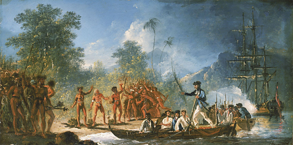 |
Figure 51. Incandescence, steam, and dark ash from Yasur fill the sky in this sketch representing Captain James Cook's landing in the 'Resolution' at Tanna Island on 5 August 1774. The form of the volcano is behind the ship, the incandescence is in the upper right next to the ship's masts. "Landing at Tanna" by William Hodges, 1775-1776, National Maritime Museum, Greenwich, London. The Maritime Museum noted that this is one of a group of panel paintings produced by Hodges of encounters with islanders during the voyage, in which the European perception of each society at the time is portrayed. Image taken from Wikimedia Commons. |
Based on numerous accounts from ships logs and other sources, volcanic activity has been continuous since that time. During periods of higher activity, multiple vents within the summit crater send ejecta 100 m or more above the crater rim, with large bombs occasionally landing hundreds of meters away. Continued activity during February-May 2019 is covered in this report with information provided by the Geo-Hazards Division, Vanuatu Meteorology and Geo-Hazards Department (VMGD) which monitors the volcano and satellite data; photographs from tourists also provide valuable information about this remote location.
VMGD has maintained Alert Level 2 at Yasur since October 2016, indicating that it is in a major state of unrest. There is a permanent exclusion zone within 395 m of the eruptive vents where access is prohibited due to multiple hazards, primarily from large incandescent bombs up to 4 m in diameter which have been ejected from the vents onto the crater rim in the past, resulting in fatalities (BGVN 20:08).
Satellite and ground based information all support high levels of thermal activity during February -May 2019. MODVOLC thermal alerts were issued 11 times in February, 27 times in March, and 20 times each in April and May. The MIROVA graph also indicated the ongoing consistently high levels of thermal energy throughout the period (figure 52). Plumes of SO2 emissions are common from Vanuatu's volcanoes; newer higher resolution data available beginning in 2019 reveal a persistent stream of SO2 from Yasur on a near-daily basis (figure 53).
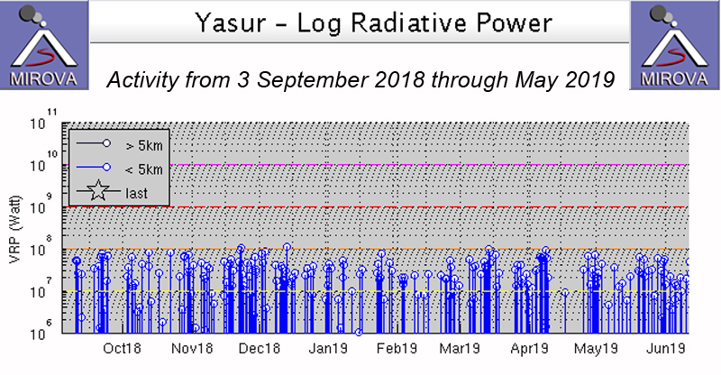 |
Figure 52. The MIROVA graph of thermal energy at Yasur from 3 September 2018 through May 2019 indicates the ongoing activity at the volcano. Courtesy of MIROVA. |
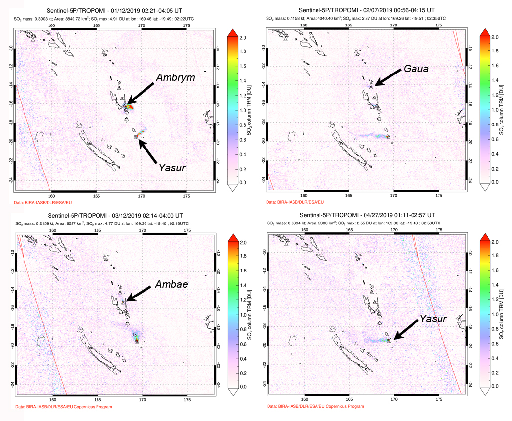 |
Figure 53. The SO2 plumes from Yasur were persistent during January-May 2019 when they were visible many days of each week throughout the period. Top left: On 12 January plumes were visible drifting E from both Ambrym (top) and Yasur (bottom). Top right: Plumes drifted W from three Vanuatu volcanoes on 7 February, Gaua (top), Ambrym (middle) and Yasur (bottom). Bottom left: On 12 March N drifting plumes could be seen from Ambae (top) and Yasur (bottom). On 27 April, only Yasur had an SO2 plume drifting W. Courtesy of Goddard Space Flight Center. |
Satellite imagery confirmed that the heat sources from Yasur were vents within the summit crater of the pyroclastic cone. Both northern and southern vent areas were active. On 7 March 2019 the N vent area had a strong thermal signal. Ten days later, on 17 March, similar intensity thermal anomalies were present in both the N and S vent areas (figure 54). On 6 April the S vent area had a stronger signal, and gas emissions from both vents were drifting N (figure 55). Satellite imagery from 21 May 2019 indicated a strong thermal signal inside the crater in the area of the vents, and included a weaker signal clearly visible on the inside E crater rim. Strong Strombolian activity or spatter sending large incandescent bombs as far as the crater rim are a likely explanation for the signal (figure 56), underscoring the hazardous nature of approaching the crater rim.
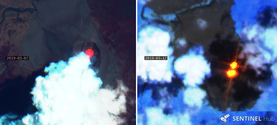 |
Figure 54. Strong thermal anomalies from the crater of Yasur's pyroclastic cone seen in satellite images confirmed the ongoing high level of activity. Left: 7 March 2019, a strong thermal anomaly from the N vent area, shown with "Geology" rendering (bands 12, 4, 2). Right: 17 March 2019, thermal anomalies at both the N and S vent areas, shown with "Atmospheric Penetration" rendering (bands 12, 11, 8A). The crater is about 500 m in diameter. Sentinel-2 satellite imagery courtesy of Sentinel Hub Playground. |
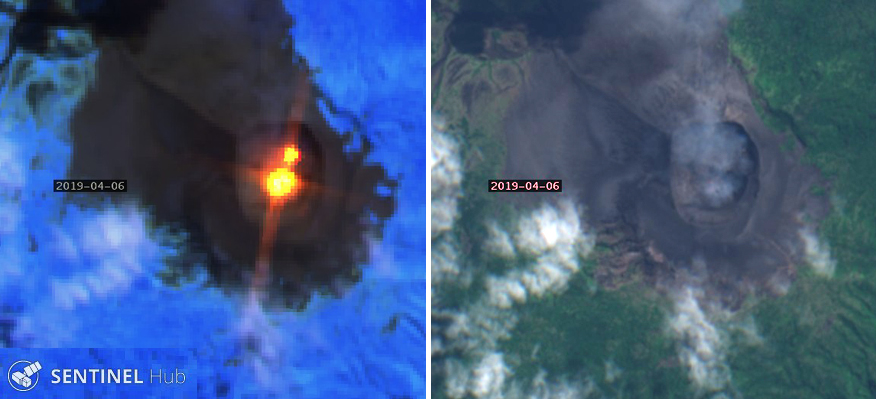 |
Figure 55. Strong thermal anomalies (left) and gas emissions (right) at Yasur were captured with different bands in the same Sentinel-2 satellite image on 6 April 2019. Left: The thermal anomaly in the S vent area was stronger than in the N vent area, "Atmospheric Penetration" rendering (bands 12, 11, 8A). Right: Gas plumes drifted N from both vent areas, "Natural color" rendering (bands 4, 3, 2). The crater is about 500 m in diameter. Sentinel-2 satellite imagery courtesy of Sentinel Hub Playground. |
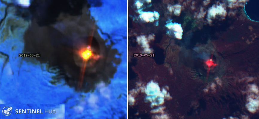 |
Figure 56. Thermal activity from the crater of Yasur on 21 May 2019 produced a strong thermal signal from the center of the crater and a weaker signal on the inside E crater rim, likely the result of hazardous incandescent bombs and ejecta, frequent products of the activity at Yasur. Left: "Atmospheric Penetration" rendering (bands 12, 11, 8A). Right: "Geology" rendering (bands 12, 4, 2). The crater is about 0.5 km in diameter. Sentinel-2 satellite imagery courtesy of Sentinel Hub Playground. |
Tourists visit Yasur on a regular basis. A former lake on the N side of Yasur has left ripples in the sand deposits over older volcanic rocks on the N side of the volcano (figure 57) since it drained in 2000 (BGVN 28:01). Visitors are allowed to approach the S rim of the crater where incandescence from both the N and S vents is usually visible (figure 58). Incandescent spatter from the convecting lava in the vents is highly dangerous and unpredictable and often covers the inner slopes of the rim as well as sending bombs outside the crater (figure 59).
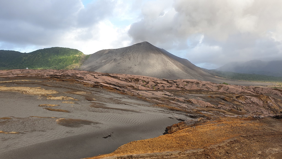 |
Figure 57. The pyroclastic cone of Yasur viewed from the north on 6 May 2019. Ripples in volcaniclastic sand in the foreground are remnants of a lake that was present on the N side of the volcano until a natural dam breached in 2000. Copyrighted photo by Nick Page, used with permission. |
 |
Figure 58. Two glowing vents were visible from the south rim of Yasur on 6 May 2019. The S vent area is in the foreground, the N vent area is in the upper left. Copyrighted by Nick Page, used with permission. |
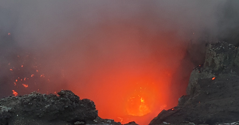 |
Figure 59. Incandescent spatter at Yasur on 6 May 2019 sent fragments of lava against the inside crater wall and onto the rim. The convecting lava in the vent can be seen in the lower foreground. Copyrighted photo by Nick Page, used with permission. |
Geological Summary. Yasur has exhibited essentially continuous Strombolian and Vulcanian activity at least since Captain Cook observed ash eruptions in 1774. This style of activity may have continued for the past 800 years. Located at the SE tip of Tanna Island in Vanuatu, this pyroclastic cone has a nearly circular, 400-m-wide summit crater. The active cone is largely contained within the small Yenkahe caldera, and is the youngest of a group of Holocene volcanic centers constructed over the down-dropped NE flank of the Pleistocene Tukosmeru volcano. The Yenkahe horst is located within the Siwi ring fracture, a 4-km-wide open feature associated with eruption of the andesitic Siwi pyroclastic sequence. Active tectonism along the Yenkahe horst accompanying eruptions has raised Port Resolution harbor more than 20 m during the past century.
Information Contacts: Geo-Hazards Division, Vanuatu Meteorology and Geo-Hazards Department (VMGD), Ministry of Climate Change Adaptation, Meteorology, Geo-Hazards, Energy, Environment and Disaster Management, Private Mail Bag 9054, Lini Highway, Port Vila, Vanuatu (URL: http://www.vmgd.gov.vu/, https://www.facebook.com/VanuatuGeohazardsObservatory/); Hawai'i Institute of Geophysics and Planetology (HIGP) MODVOLC Thermal Alerts System, School of Ocean and Earth Science and Technology (SOEST), Univ. of Hawai'i, 2525 Correa Road, Honolulu, HI 96822, USA (URL: http://modis.higp.hawaii.edu/); MIROVA (Middle InfraRed Observation of Volcanic Activity), a collaborative project between the Universities of Turin and Florence (Italy) supported by the Centre for Volcanic Risk of the Italian Civil Protection Department (URL: http://www.mirovaweb.it/); Sentinel Hub Playground (URL: https://www.sentinel-hub.com/explore/sentinel-playground); Global Sulfur Dioxide Monitoring Page, Atmospheric Chemistry and Dynamics Laboratory, NASA Goddard Space Flight Center (NASA/GSFC), 8800 Greenbelt Road, Goddard, Maryland, USA (URL: https://so2.gsfc.nasa.gov/); The Captain Cook Society (URL: https://www.captaincooksociety.com/home/detail/225-years-ago-july-september-1774); Royal Museums Greenwich (URL: https://collections.rmg.co.uk/collections/objects/13383.html); Wikimedia Commons, (URL: https://commons.wikimedia.org/wiki/File:The_Landing_at_Tana_one_of_the_New_Hebrides,_by_William_Hodges.jpg); Nick Page, Australia,Flickr: (URL: https://www.flickr.com/photos/152585166@N08/).