Report on Kilauea (United States) — May 1991

Bulletin of the Global Volcanism Network, vol. 16, no. 5 (May 1991)
Managing Editor: Lindsay McClelland.
Kilauea (United States) E rift lava continues to flow through tubes into the ocean
Please cite this report as:
Global Volcanism Program, 1991. Report on Kilauea (United States) (McClelland, L., ed.). Bulletin of the Global Volcanism Network, 16:5. Smithsonian Institution. https://doi.org/10.5479/si.GVP.BGVN199105-332010
Kilauea
United States
19.421°N, 155.287°W; summit elev. 1222 m
All times are local (unless otherwise noted)
Lava . . . continued to flow into the sea at two sites on the W side of the flow field (figure 79). More than 95% of the lava advanced through the Wahaula tube system, which divided a few hundred meters from the coast and fed the W and E entry points in the Poupou area. The W Poupou entry has been persistently explosive, continuing to throw tephra onto a large littoral cone on the old sea cliff. Growth of the littoral cone halted in May as erosional mechanisms (weather and cliff collapse) kept pace with explosive activity at the lava/sea interface. Below the old sea cliff, the W entry had built a small bench that extended <10-15 m into the ocean and was easily broken up by high surf. The E branch of the tube continued to feed the E Poupou entry points, which in previous months had built a sizeable 2-level bench below the old sea cliff. Throughout May, there were at least two major entry points off this bench. In early May, fluid lava flows broke out onto the E bench from its junction with the old sea cliff, covering the W side of the bench and entering the ocean. Successive overflows and inflation (perhaps caused by lava underplating) continued to build the lower bench, and by the end of the month it was within 1-2 m of the upper bench.
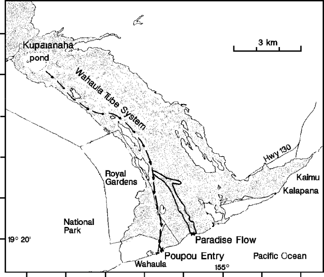 |
Figure 79. Lava produced by Kīlauea's Kupaianaha vent, 1983-91. Arrows indicate flow in tubes and crosses at the coast mark sites where lava was entering the ocean in May 1991. Surface flows are shown above the tube's E and W branches. Courtesy of HVO. |
Small lava flows broke out during May from the Wahaula tube between ~180 m (600 ft) elevation and the flat area near the coast. Two large flows were active. One (Waiaka) moved downslope atop the Wahaula tube in April, turning E off the tube near the coast and entering the ocean 17 April-2 May. This flow's activity declined during the first 2 weeks in May, and the flow was stagnant by the 16th. In mid-May, a new (Paradise) flow broke away from the Wahaula tube between 150 and 180 m elevation (500-600 ft) and established a new tube to the E. By the end of May, this flow was entering the ocean at the same site as the Waiaka flow.
A lava pond remained in the bottom of Pu`u `O`o crater through May. Kupaianaha's lava pond remained completely crusted over. Fume from the pond area diminished significantly, and the primary area of degassing shifted from the Kupaianaha shield area to a skylight in the tube system near 620 m (2,050 ft) elevation. In early May, all of the skylights along the Wahaula tube overflowed, closing some of those at lower elevations. The upper skylights remained open, and observations of times required for logs thrown into the upper skylight to reach the lower skylight yielded lava velocities of 1.4 m/s.
Geological Summary. Kilauea overlaps the E flank of the massive Mauna Loa shield volcano in the island of Hawaii. Eruptions are prominent in Polynesian legends; written documentation since 1820 records frequent summit and flank lava flow eruptions interspersed with periods of long-term lava lake activity at Halemaumau crater in the summit caldera until 1924. The 3 x 5 km caldera was formed in several stages about 1,500 years ago and during the 18th century; eruptions have also originated from the lengthy East and Southwest rift zones, which extend to the ocean in both directions. About 90% of the surface of the basaltic shield volcano is formed of lava flows less than about 1,100 years old; 70% of the surface is younger than 600 years. The long-term eruption from the East rift zone between 1983 and 2018 produced lava flows covering more than 100 km2, destroyed hundreds of houses, and added new coastline.
Information Contacts: T. Moulds, HVO.