Report on Lewotobi (Indonesia) — July 1991
Bulletin of the Global Volcanism Network, vol. 16, no. 7 (July 1991)
Managing Editor: Lindsay McClelland.
Lewotobi (Indonesia) Strombolian activity
Please cite this report as:
Global Volcanism Program, 1991. Report on Lewotobi (Indonesia) (McClelland, L., ed.). Bulletin of the Global Volcanism Network, 16:7. Smithsonian Institution. https://doi.org/10.5479/si.GVP.BGVN199107-264180
Lewotobi
Indonesia
8.542°S, 122.775°E; summit elev. 1703 m
All times are local (unless otherwise noted)
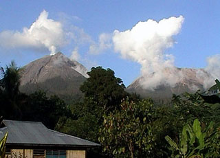
Press releases reported increased activity, with small eruptions occurring around 19 July. One eruption reportedly ejected incandescent material 100 m high, dropping hot ash (smelling of sulfur) onto nearby areas and causing residents to flee. At 1645 on 29 July, a 300-m-high ash cloud extending ~35 km W was reported by pilots on Qantas flight A61. By the week of 14-19 August the volcano was no longer exploding, and gas emissions, 50-100 m high, appeared to be decreasing.
Geological Summary. The Lewotobi edifice in eastern Flores Island is composed of the two adjacent Lewotobi Laki-laki and Lewotobi Perempuan stratovolcanoes (the "husband and wife"). Their summits are less than 2 km apart along a NW-SE line. The conical Laki-laki to the NW has been frequently active during the 19th and 20th centuries, while the taller and broader Perempuan has had observed eruptions in 1921 and 1935. Small lava domes have grown during the 20th century in both of the summit craters, which are open to the north. A prominent cone, Iliwokar, occurs on the E flank of Perampuan.
Information Contacts: W. Modjo, VSI; ICAO; UPI.