Report on Kirishimayama (Japan) — November 1991

Bulletin of the Global Volcanism Network, vol. 16, no. 11 (November 1991)
Managing Editor: Lindsay McClelland.
Kirishimayama (Japan) Increased seismicity; gas emission
Please cite this report as:
Global Volcanism Program, 1991. Report on Kirishimayama (Japan) (McClelland, L., ed.). Bulletin of the Global Volcanism Network, 16:11. Smithsonian Institution. https://doi.org/10.5479/si.GVP.BGVN199111-282090
Kirishimayama
Japan
31.934°N, 130.862°E; summit elev. 1700 m
All times are local (unless otherwise noted)
A swarm of microearthquakes began at around 2300 on 13 November beneath Shinmoe-dake cone. The number of earthquakes increased sharply the next day, and seismicity remained elevated until the morning of 26 November, with the exception of two brief quiet periods on 19-20 and 23-24 November (figure 2). Seismicity reached the highest level since the start of monitoring in 1965 (figure 3), while episodic and continuous volcanic tremor were recorded for the first time. Five volcanic tremor episodes were recorded 13-23 November, ranging from 0.2 to 2.5 µm in amplitude and 1-7 minutes in duration. Continuous weak volcanic tremor (0.1 µm amplitude) began at 0305 on 26 November.
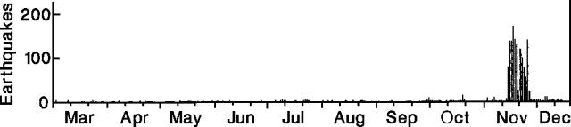 |
Figure 2. Daily number of earthquakes at Kirishima, 1 March-15 December 1991. Courtesy of JMA. |
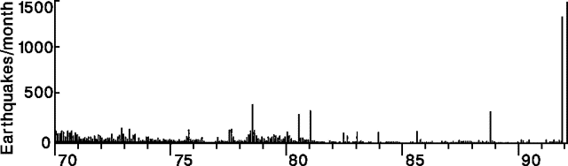 |
Figure 3. Monthly number of earthquakes at Kirishima, January 1970-November 1991. Courtesy of JMA. |
Steam emission was first reported by tourists on 24 November, and confirmed during an overflight the following day. The plume rose 200-500 m from fumaroles on the E inner wall of the main crater; previous steam emission, last observed in 1990, had usually reached only a few meters high. Tremor and steam emissions continued as of 16 December.
Geological Summary. Kirishimayama is a large group of more than 20 Quaternary volcanoes located north of Kagoshima Bay. The late-Pleistocene to Holocene dominantly andesitic group consists of stratovolcanoes, pyroclastic cones, maars, and underlying shield volcanoes located over an area of 20 x 30 km. The larger stratovolcanoes are scattered throughout the field, with the centrally located Karakunidake being the highest. Onamiike and Miike, the two largest maars, are located SW of Karakunidake and at its far eastern end, respectively. Holocene eruptions have been concentrated along an E-W line of vents from Miike to Ohachi, and at Shinmoedake to the NE. Frequent small-to-moderate explosive eruptions have been recorded since the 8th century.
Information Contacts: JMA.